Browse Listings
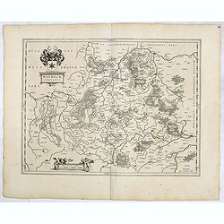
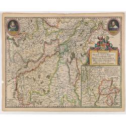
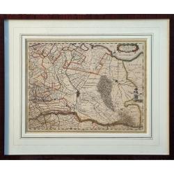
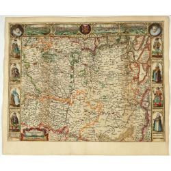
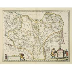
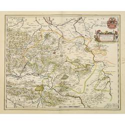
Waldeck Comitatus.
FIRST EDITION, FIRST ISSUE OF THIS MAP. From the 1634 edition of Blaeu's Atlas Novus, the first edition of this work.Important early map of Waldeck. Attractive coat of ar...
Date: Amsterdam, 1634
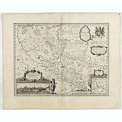
Osnabrugensis Episcopatus.
Originally engraved for Jodocus Hondius II, at his death in August 1629 this map was, among 39 other copper plates, purchased by Willem Blaeu who deleted Hondius' name an...
Date: Amsterdam, 1634
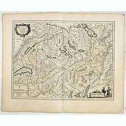
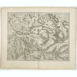
Helvetia cum finitimis regionibus confoederatis.
Detailed and finely engraved map of Switzerland with a pair of fine cartouches.From early on Willem Jansz. Blaeu aimed of publishing an atlas to compete with the Hondius-...
Date: Amsterdam, 1634
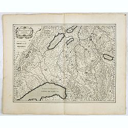
Das Wiflispurgergow.
Detailed map of South-western Switzerland after Gerhard Mercator's map of the same. With ornamental title cartouche and German text on the verso.It shows Geneva, Lake Gen...
Date: Amsterdam, 1634
Argow cum parte merid. Zurichgow.
Nice map of Canton Aargau and parts of the Cantons Schwyz, Zürich and Glarus. Includes the cities of Bern and Luzern.Based on the cartography of Gerard Mercator and very...
- $100 / ≈ €87
Date: Amsterdam, 1634
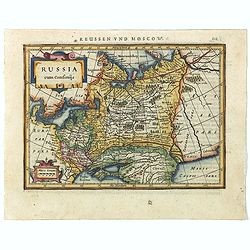
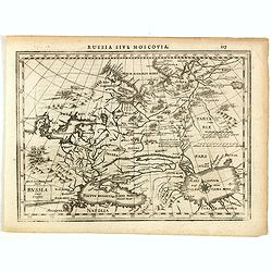
Russia cum Confinijs.
Charming small map of European Russia. Nicely detailed including engraved forests and mountains and embellished with two strapwork cartouches. Latin text on verso.
- $220 / ≈ €191
Date: Amsterdam, 1634
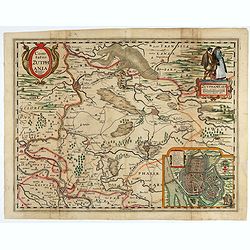
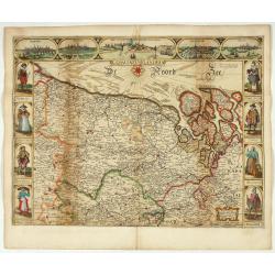
Comitatus Zutphania.
With an inset a plan of the town of Zutphen. Originally published by Petrus Kaerius in 1617. Published by Visscher in his "Belgium sive Germania Inferior continens p...
Date: Amsterdam, 1634
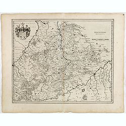
Wirtenberg Ducatus.
FIRST EDITION, FIRST ISSUE OF THIS MAP. From the 1634 edition of Blaeu's Atlas Novus, the first edition of this work. PROOF STATE with blank upper right corner, only incl...
Date: Amsterdam, 1634
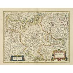
De Hertochdommen Gulick Cleve Berghe en de Graefschappen...
It is one of Blaeu's early maps: It was only published between 1630 and 1635 in three editions of the "Appendix" and one of the "Theatrum". In the lef...
Date: Amsterdam, 1635

Mappa Aestivarum Insularum alias Barmudas.
Blaeu based his work on John Speed's remarkably accurate map of 1626-1627. It shows the island divided into tribes and lots, and below the map itself appear the names of ...
Date: Amsterdam, 1635
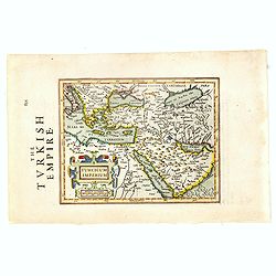
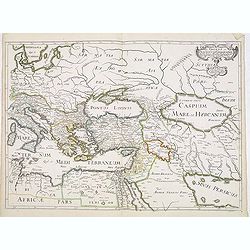
Turcicum Imperium.
Early map of Turkey, the Arabian peninsula and eastern part of the Mediterranean.From the English edition of Mercator's Atlas Minor. This edition 1635. English text on ve...
Date: Amsterdam, 1635
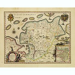
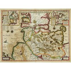
Typus Frisiae Orientalis.
Finely engraved map of east Frisia in Germany with the Watten islands. With inset map of the area south of Emden. Prepared by Ubbo Emmius (1547-1625). A very decorative t...
Date: Amsterdam, 1635
![Zurichgow et Basiliensis Provincia [ Zurich].](/uploads/cache/60807-250x250.jpg)
Zurichgow et Basiliensis Provincia [ Zurich].
Finely engraved map including the towns of Basel, Lucerne, Zurich, etc.
- $400 / ≈ €347
Date: Amsterdam, 1635
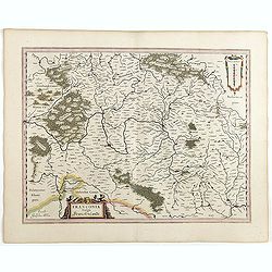
Franconia vulgo Franckenlandt.
Fine copy centered on Bamberg, Nuremberg, Würzburg, and Nuremberg. French text on verso. Würzburg is the main city in Franconian wine country. Grapevines cover the stee...
Date: Amsterdam, 1635

Constantinopolitanae urbis effigies ad vivum expressa, quam Turcae Stampoldam vocant. A° MDCXXXV.
Large, decorative view of the city of Constantinople, with legend across the bottom. It is beautifully engraved with quaint scenes of everyday life, including hunters wit...
Date: Frankfurt, 1635

Asia secunda pars in forma Pegasi.
UNRECORDED PLATE or STATE. Asia depicted as the flying horse Pegasus. Below the depiction 3 lines of engraved Latin text. Double page copper engraved map from Heinrich B�...
Date: Brunswick, ca. 1635
Ultraiectum Dominium.
A highly detailed map of Utrecht and its surroundings in the Netherlands.Additional shipping costs apply. The item is located in Schiedam (The Netherlands) and can be s...
Date: Amsterdam, ca 1635

Nouvelle et exacte Carte du Duche de Brabant. . .
A very rare example of a map of the Duchy of Brabant. Title cartouche in the lower left-hand corner. A very rare issue of this map of Brabant. Cornelis Danckerts II. copi...
Date: Amsterdam, 1635
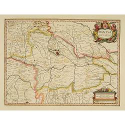
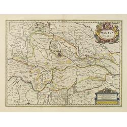
Mantua ducatus.
Important map of northern Italy centered on the dramatic fortress of Mantua.
- $300 / ≈ €260
Date: Amsterdam, 1635
Ducatus Holsatiae nova tabula.
Finely engraved map centered on the area north of Hamburg and Lubeck with two insets. This is a second state of a map initially made by Jodocus Hondius.
- $250 / ≈ €217
Date: Amsterdam, 1635
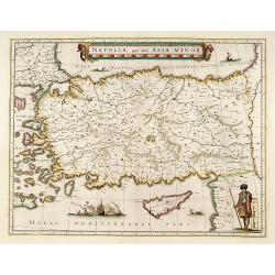
Natolia, quae olim Asia minor.
A finely designed map of Turkey and Cyprus from the great Blaeu family of Amsterdam. The decoration consist of a colored title cartouche, sea monsters, a naval engagement...
Date: Amsterdam, 1635
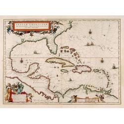
Insulae Americanae in Oceano Septentrionali cum Terris adiacentibus.
General map of the West Indies extending from Virginia to the mouth of the Orinoco, and destined to be copied in various shapes by many other publishers. Title cartouche ...
- $1000 / ≈ €868
Date: Amsterdam, 1635
![[Lot of 14 maps of Germany] Nova Totius Germaniae Descriptio.](/uploads/cache/19045-(3)-250x250.jpg)
[Lot of 14 maps of Germany] Nova Totius Germaniae Descriptio.
Willem Blaeu, founder of the famous publishing firm. Originally publishing pilot-guides, he issued his first atlas, 'Atlantis Appendix', in 1630, followed by his "...
- $500 / ≈ €434
Date: 1635
Corte ende waerachtige beschrijvinghe van het Fort de Schencken-Schans. . .
Map of the Schencken-Schans fortress printed with text. Text in Dutch and French.
Date: Antwerp, 1635
Asiae Nova Descriptio.
Final State of Pieter Van Den Keere's Rare Map of Asia--The first map of Asia to include decorative panels.The map has an interesting south positioning of the Caspian Sea...
Date: Amsterdam, 1636
Russia cum confinijs.
A rare map of Russia in a first edition. In the second state the coastline of Scandinavia is completed, the title changed and the name of the engraver Dirck Cornelissen S...
- $250 / ≈ €217
Date: Amsterdam, Cloppenburgh, 1630-1636
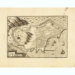
St Tropez.
Published by Nicolas Tassin in "Les Plans et Profilz de toutes principalles Villes et lieux considerable de France." The first edition of this work was publish...
- $100 / ≈ €87
Date: Paris, Sébastien Cramoisy, 1636
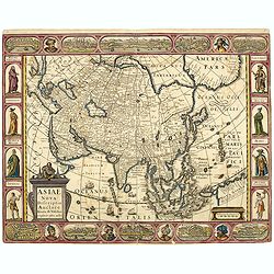
Asiae Nova Descriptio.
Final State of Pieter Van Den Keere's Rare Map of Asia -- The first map of Asia to include decorative panels. Published by N.J.Visscher and engraved by Abraham Goos, embe...
Date: Amsterdam, 1636

Amstelodamum, Celebre Emporium Forma Plana.
Second state of this rare and decorative plan of Amsterdam with Visscher's imprint. With a panoramic view seen from the IJ and further insets of Council House, The Exchan...
Date: Amsterdam, c. 1636
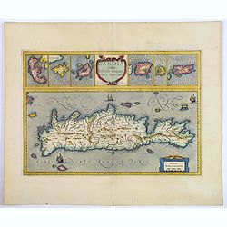
Candia cum Insulis aliquot circa Graeciam.
An attractive (if rather inaccurate) map of Crete, with insets of the islands of Corfu, Zante, Milos, Nicsia, Santorini, and Scarpanto.
Date: Amsterdam, ca 1636
Germaniae nova et accurata delineatio.. 1631.
Striking example of Hondius' map of the German Empire, extending from the Low Countries in the Northwest to the Baltic, Poland and Russia in the Northeast and Italy and t...
- $400 / ≈ €347
Date: Amsterdam, 1636

Loudunois. Laudunum / Mirebalais.
Two maps on one sheet. Centered on Loudun and Mirebeau. Showing lower left cartouche putti playing with grapes.German text on verso.
Date: Amsterdam, after 1636

Belgium, sive Inferior Germania post omnes…
Third state (only 3 recorded copies) of this scarce map of the 17 Provinces, published by Peter Verbiest in Antwerp. West at top. The maps by Pieter van den Keere in 1607...
Date: Antwerp, 1636

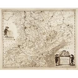
Ducatus Limburg.
A very rare issue of this map of Limburg. Cornelis Danckerts II copied the folio map of H.Hondius.The publisher's address was placed in the lower right-hand corner. The c...
Date: Amsterdam, 1636
Ducatus Limburg.
A very rare issue of this map of Limburg. Cornelis Danckerts II. copied the folio map of H.Hondius.The publisher's address was placed in the lower right-hand corner. The ...
Date: Amsterdam, 1636
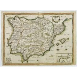
Carte generale d'Hespagne.
Rare map of Spain and Portugal from "Theatre des Gaules". In lower right corner a little inset of Cadiz.Very rare in original color.
- $600 / ≈ €521
Date: Paris, 1637
Romani Imperii Oriens est Descriptio Geographica. . .
A fine map of the Near East. The map was first published by Tavernier and later by Mariette. This edition is dated 1637 with the address of Pierre Mariette at rue S. Jacq...
Date: Paris, after 1637
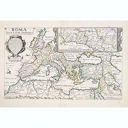
Roma dentium Domina.
Rare map of Europe during the Roman Empire. In upper right corner inset map of the area around Rome "Imperium Romanum Nasces (305x250mm.) Prepared by P.Briet and pub...
- $1500 / ≈ €1302
Date: Paris, 1637
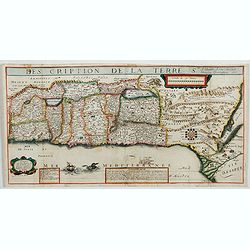
Description de la Terre Ste a laquelle A esté adjouté Diverses Observations 1637.
Very rare map of the Holy Land published by Jean Boisseau and engraved by H. Picart in Paris. "A Paris Chez Iean Boisseau en lisle du Palais sur le quay qui regarde ...
- $2500 / ≈ €2169
Date: Paris, 1637
Brabantia Ducatus.
Second state of this scarce Carte-a-Figures map of Brabant, published by Peter Verbiest in Antwerp, decorated with three-sided panels. This is the variant without a botto...
Date: Antwerp, 1637
Comitatus Flandria.
Second state of this scarce Carte-a-Figures of Flanders, published by Peter Verbiest in Antwerp decorated with 3 side panels without bottom border (variant of the second ...
Date: Antwerp, 1637

Comitatus Zutphania.
A very detailed map of this area, including Arnhem, Nijmegen, Zutphen, Groenlo, etc. First imprint, from a Latin edition of the scarce Atlas Appendix.
Date: Amsterdam, 1637
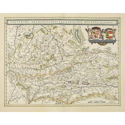
Saltzburg Archiepiscopatus, et Carinthia Ducatus
Handsome map of the archbishopric of Salzburg and the Duchy of Carinthia.Title in banner form with two coats of arms and three cherubs decorating the map.As Willem Blaeu ...
Date: Amsterdam, 1638
Taurica Chersonesus, Nostra aetate Przecopsca, et Gazara dicitur.
Part of Russia with in the north Smolensk and Moscow and in the south the Black Sea.As Willem Blaeu died in 1638 most of his maps are actually published by his son Joan. ...
Date: Amsterdam, 1638
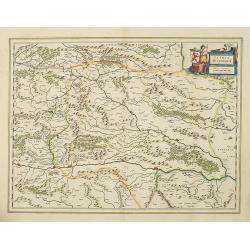
Stiria Steyermarck.
Covering the eastern part of Austria, Styria and Carinthia, centered on the town of Graz.As Willem Blaeu died in 1638 most of his maps are actually published by his son J...
Date: Amsterdam, 1638
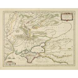
Walachia, Servia, Bulgaria, Romania.
Striking map of the region centered on the Lower Danube, Bulgaria, Romania, Serbia and Macedonia. Includes decorative cartouche, coat of arms, etc. Latin text on verso.Th...
Date: Amsterdam, 1638
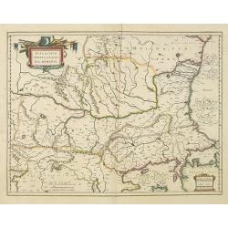
Karstia, Camiola, Histria et Windorum Marchia.
Including the Gulf of Trieste, Venice and the northern part of former Yugoslavia. Prepared by Gerard Mercator.As Willem Blaeu died in 1638 most of his maps are actually p...
Date: Amsterdam, 1638

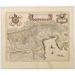
Dominio Veneto nell' Italia.
With the Gulf of Venice. Including the towns of Cremona, Brescia, Venice, etc.As Willem Blaeu died in 1638 most of his maps are actually published by his son Joan. This m...
Date: Amsterdam, 1638
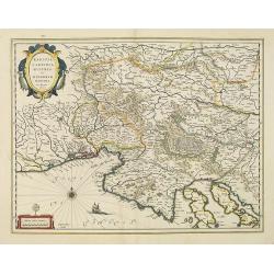
Mantua ducatus.
Centered at the town of Mantua.As Willem Blaeu died in 1638 most of his maps are actually published by his son Joan. This map carries his (engraved) signature and was act...
Date: Amsterdam, 1638
Mediolanum Ducatus.
Very fine map centered on Milan Including Lake Como, Lake Garda, Lake Majore, Parma, etc.As Willem Blaeu died in 1638 most of his maps are actually published by his son J...
Date: Amsterdam, 1638
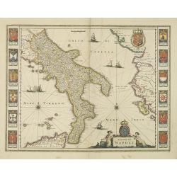
Regno di Napoli.
To the left and right 12 coats of arms of different regions.As Willem Blaeu died in 1638 most of his maps are actually published by his son Joan. This map was actually pu...
Date: Amsterdam, 1638
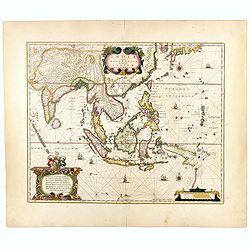
India quae Orientalis dicitur, et Insulae Adiacentes.
Map of South East Asia, noteworthy for being one of the first maps to include, albeit incompletely, the discoveries made by the Dutch vessel Duyfken in 1605-1606 in the G...
- $1750 / ≈ €1519
Date: Amsterdam, 1638
Tartaria sive Magni Chami imperium.
Detailed and decorative map of Tartary and Northern part of China. Northern tip of Korea included. The Chinese Great Wall is depicted, with Central Asia, extending from M...
- $500 / ≈ €434
Date: Amsterdam, 1638
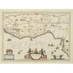
Guinea.
An attractive map covered with intersecting rhumb lines and decorated with monkeys, lions, elephants and native figures. With a dedication to Dr. Nicolas Tulp.As Willem B...
- $750 / ≈ €651
Date: Amsterdam, 1638
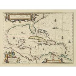
Insulae Americanae in Oceano Septentrionali cum Terris adiacentibus.
General map of the West Indies extending from Virginia to the mouth of the Orinoco, and destined to be copied in various shapes by many other publishers.Title cartouche t...
- $1800 / ≈ €1562
Date: Amsterdam, 1638
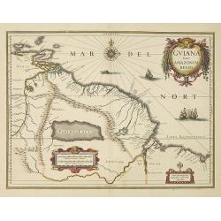
Guiana sive Amazonum Regio.
Willem Blaeu’s decorative map of the Guianas, Lake Parima (Parime Lacus), and the route to El Dorado was initially issued in 1630 (with some variants were published wel...
- $400 / ≈ €347
Date: Amsterdam, 1638
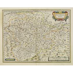
Westphalia Ducatus.
Elegantly engraved map of Westphalia including Hamm and Lippstadt. The mountainous topography is graphically depicted and several small coats of arms dot the map. Strapwo...
Date: Amsterdam, 1638
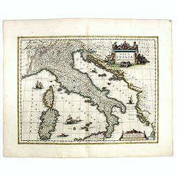
Nova Italiae delineatio.
Originally engraved for Jodocus Hondius II, at his death in August 1629 this map was, among other copper plates,purchased by Willem Blaeu who trimmed the figured borders,...
Date: Amsterdam, 1638
![[Title page] Nouveau Theatre Du Mond ou Nouvel Atlas . . .](/uploads/cache/43280-250x250.jpg)
[Title page] Nouveau Theatre Du Mond ou Nouvel Atlas . . .
The title page from Joahannes Janssonius / Hondius's Atlas Novus. Marvelous 18 coat of arms, armillary sphere, celestial and terrestrial globes and beautifully engraved f...
Date: Amsterdam, 1638
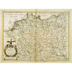
Carte Generalle de la Germanie.
A rare map of the whole Germany. Very decorative title cartouche on the lower left-hand corner.With the mention A Paris chez Nicolas Berey Enlumineur de la Reine, Demeura...
- $1000 / ≈ €868
Date: Paris, 1638

Polonia regnum et Silesia ducatus.
Very decorative map of Poland embellished with two cartouches and two coats of arms surmounted by cherubs and female figures. Showing the region from the Oder east to Pod...
Date: Amsterdam, 1638
Histoire de la Navigation.
A fine example of Linschoten's classic illustrated travelogue to the East and West Indies, termed by Lach “the most important of the firsthand accounts published indepe...
Date: Amsterdam, Evert Cloppenburgh, 1638
Dominio Veneto nell' Italia.
Blaeu's map of the Dominion of Venice. This influential map is adorned by a cartouche of the city of Venice, a winged Lion, a title cartouche of putti and an entwined rib...
Date: Amsterdam, 1635-1638
![[Title page] Atlantis Novi Pars Secunda, exhibens Germaniam inferiorem, Galliam, Helvetiam, atque Hispaniam.](/uploads/cache/43277-250x250.jpg)
[Title page] Atlantis Novi Pars Secunda, exhibens Germaniam inferiorem, Galliam, Helvetiam, atque Hispaniam.
Highly decorative, and finely engraved architectural façade with figures topped with an armillary sphere.. The title is printed on a paste-on slip. Some elements highlig...
Date: Amsterdam, 1638
Bravnswyck et Meydburg. . .
As Willem Blaeu died in 1638 most of his maps are actually published by his son Joan. This maps carries his (engraved) signature and was actually published in volume II o...
Date: Amsterdam, 1638
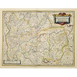
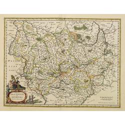
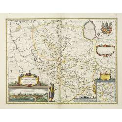
Monasteriensis Episcopatus.
A very detailed map of Germany centered on Munster and Linge. Also showing Wessel to the top of the map and Oldenburg to the right. North to the right. The map is adorned...
Date: Amsterdam, 1638
Osnabrugensis episcopatus.
A beautiful map of Munster centered on the city of Osnabruck. Prepared by Joannes Michael Gigas (1580-1650+), a doctor, mathematician and geographer. Showing an inset wit...
Date: Amsterdam, 1638
Mansfeldia Comitatus. . .
Centered on Mansfield and prepared by Telemann Stella (1527-1589) a German cartographer who made maps of Germany and the Holy Land.As Willem Blaeu died in 1638 most of hi...
Date: Amsterdam, 1638
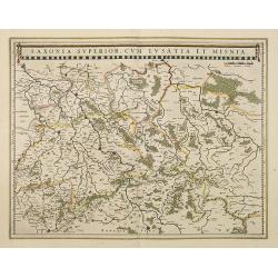
Saxonia Superior, cum Lusatia et Misnia.
Finely engraved and detailed map of Saxony including Halle, Leipzig, Meissen, and Dresden. Filled with forests and tiny villages. It presents Prague close to the centre o...
Date: Amsterdam, 1638
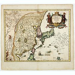
China Veteribus Sinarum Regio nunc Incolis Tame dicta.
Fine map of China, based on the first of Blaeu's maps of China. In the west by the Great Wall is shown, among Taiwan is named Pakan al I. Formosa, although Tayoan is name...
- $950 / ≈ €824
Date: Frankfurt am Main, 1638
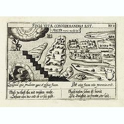
Malta maris medit.inf.
The representation of the town of Valletta on MaltaMeisner added in its center point a metaphorical representation of a medical doctor speaking out a baroque sentence of ...
- $400 / ≈ €347
Date: Frankfurt, 1638
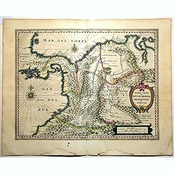
Terra Firma et Novum Regnum Granatense et Popayan.
A handsome map of modern-day Panama and Colombia. The cartouches and decoration are colored in an artistic way. Very fine and rare with this type of coloring.From "l...
Date: Amsterdam, 1635-1638
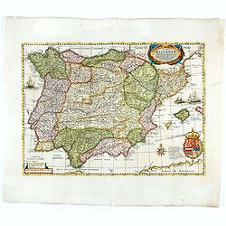
Typus Hispaniae ab Hesselo Gerardo delineata. . .
Decorative map of the kingdom of Spain and Portugal by Joan. Janssonius after the cartographic source by Hessel Gerard. Embellished by sailing ship, compass roses, and co...
Date: Amsterdam, 1638
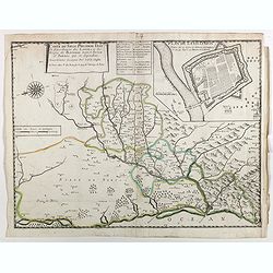
Carte du siège présidial Dax et seneschaucee des Lannes et des sieges de Bayonne sainct sever et Tartas qui en dependent Nouvellement dessignee Par le Sr de Classun.
Very rare map including Bayonne and Dax in the south west of France. With inset plan of "Plan de la ville Dax.". Engraved by Henri le Roy. With the address &quo...
Date: Paris, 1638
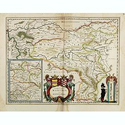
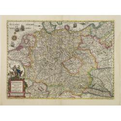
Comitatus Marchia et Ravensberg.
With an inset of Ravensberg comitatus. Decorative title cartouche with coats of arms. Scale cartouche with a surveyor.As Willem Blaeu died in 1638 most of his maps are ac...
- $80 / ≈ €69
Date: Amsterdam, 1638
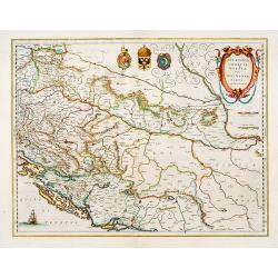
Sclavonia, Croatia cum Dalmatiae Parte.
Excellent map with coat-of-arms focusing specifically on the embattled nations of the former Yugoslavia.
Date: Amsterdam, 1638
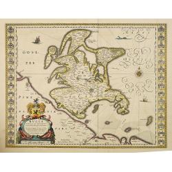
Rugia Insula ac ducatus. . .
Willem Blaeu's highly decorative map of the island of Rugen in the Baltic Sea from a map by Eihard Lubin. Embellished with a title-cartouches, and 30 coats-of-arms in the...
- $300 / ≈ €260
Date: Amsterdam, 1638

Carte du Siège Présidial Dax... Nouvellement Deseignee Par le...
Very rare map including Bayonne and Dax in the southwest of France. With inset plan of "Plan de la ville Dax.". With the address "Chez F. Dela Pointe sur l...
Date: Paris, 1638
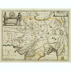
Magni Mogolis Imperium.
An attractive map of northern part of India, Tibet, Iran to Burma. The travel route from Kabul to Surat is the most prominent feature of the map. Richly decorated with st...
- $500 / ≈ €434
Date: Amsterdam, after 1638
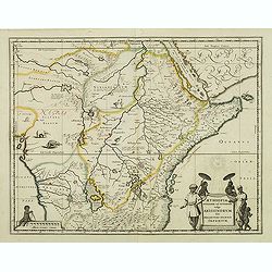
Aethiopia Superior vel Interior vulgo Abissinorum.
An attractive map of Eastern Africa and the fictitious kingdom of Prester John. The map shows a major section of central and eastern Africa including Mozambique north to ...
- $450 / ≈ €390
Date: Amsterdam, 1638