Browse Listings
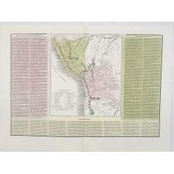
Le due Repubbliche . . . la Confederazione Peruviana . . . Bolivia . . .
A rare and detailed double-page map of Peru and Bolivia. Map is surrounded by an explanatory historical text about the countries in pink, yellow and green background colo...
- $100 / ≈ €85
Date: Venice, 1840
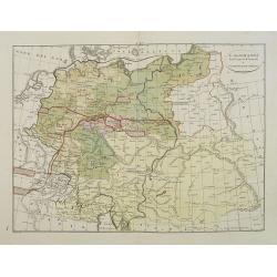
L'Alemagna . . .
A rare double-page map of Germany and Poland. Prepared by Las Casas and engraved by G.V.Pasquali for l'Atlante Storico, Letterario, Biografico, Archeologico. . . with at...
- $50 / ≈ €42
Date: Venice, 1840
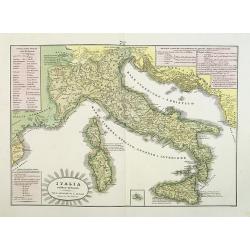
L'Italia antica-romana.
A rare and detailed double-page map of ancient Italy. According to the title cartouche, prepared by A de La Sage for l'Atlante Storico, Letterario, Biografico, Archeologi...
Date: Venice, 1840
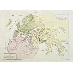
Il mondo cocsciuto dagli antichi e le laggiori antiche monarchie Persiana, Macedone, Romana . . .
A rare double-page map of the so-called Empire of Alexander the Great (also known as the Macedonian Empire or the Hellenistic Empire ) refers to that great empire , which...
Date: Venice, 1840
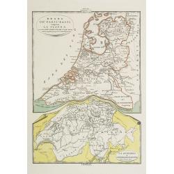
Regno de' Paesi-Bassi compresa la Olanda . . . / La Svizzera . . .
Two rare and detailed maps of The Netherland (210 x 230mm. ) and Switzerland (140 x 230mm.) According to the title cartouche, prepared by J.A.Buchon and A de La Sage for ...
Date: Venice, 1840
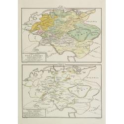
I dieci circoli Della Germania . . . / Permute e Secolarizzazioni Nella Germania . . .
Two rare maps of Germany: Top map: 160 x 235mm. Bottom map: 160 x 235mm.Prepared by Las Casas for l'Atlante Storico, Letterario, Biografico, Archeologico. . . with attri...
- $30 / ≈ €25
Date: Venice, 1840
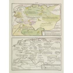
La Germania, suoi ducati e dependenze . . . /Origine e derivazione de principali stati . . .
Two rare maps of ancient Germany: Top map: 160 x 235mm. Bottom map: 160 x 235mm.Prepared by Las Casas for l'Atlante Storico, Letterario, Biografico, Archeologico. . . wi...
- $25 / ≈ €21
Date: Venice, 1840
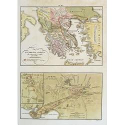
La Grecia Antica . . . / Atene e sue vicinanze . . .
Two rare maps, one of Greece map 175 x 240mm. and the other of Athens 140 x 240mm. with an inset map of Sparta.From l'Atlante Storico, Letterario, Biografico, Archeologic...
Date: Venice, 1840
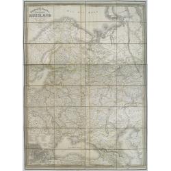
General karte vom europaischen Russland.
Rare second edition of a lithographed wall map of the European part of the Russian empire, at a scale of about 1:3,200,000. With the title in a elaborately decorated lett...
Date: Weimar, Geographisches Institut, 1840

Le Vaza ou Perroquet noir/ Le Mascarin.
Decorative lithography from a later edition of ,Histoire naturelle, by Georges-Louis Leclerc, comte de BUFFON, this great naturalist (1707-88) spent the greater part of h...
- $80 / ≈ €68
Date: Paris, 1840
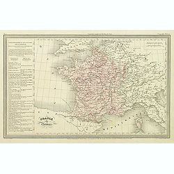
France par Provinces.
Finely engraved map prepared by A.H.Dufour and engraved by Giraldon-Bovinet. Published by Jules Renouard in his uncommon atlas "Le globe Atlas classique Universel de...
- $30 / ≈ €25
Date: Paris, Jules Renouard, ca.1840
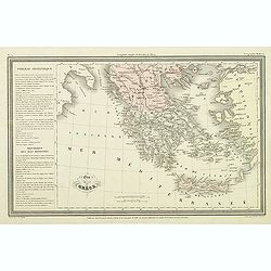
Etat de la Grèce.
Finely engraved map of Greece prepared by A.H.Dufour and engraved by Giraldon-Bovinet. Published by Jules Renouard in his uncommon atlas "Le globe Atlas classique Un...
- $50 / ≈ €42
Date: Paris, Jules Renouard, ca.1840
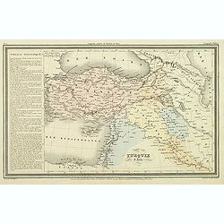
Turquie d'Asie.
Finely engraved map of Turkey, Cyprus, Palestine, Kurdistan and Iraq, prepared by A.H.Dufour and engraved by Giraldon-Bovinet. Published by Jules Renouard in his uncommon...
- $50 / ≈ €42
Date: Paris, Jules Renouard, ca.1840
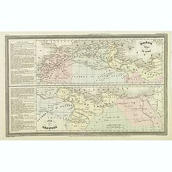
Marok Alger et Tunis. / Etat de Tripoli.
Two maps on one sheet. Finely engraved map of North Africa and Libya, prepared by A.H.Dufour and engraved by Giraldon-Bovinet. Published by Jules Renouard in his uncommon...
- $40 / ≈ €34
Date: Paris, Jules Renouard, ca.1840
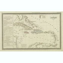
Antilles.
Finely engraved map of the Caribbean, with a color key to Spanish, English, French, Danish, Dutch and Swedish possessions, prepared by A.H.Dufour and engraved by Giraldon...
Date: Paris, Jules Renouard, ca.1840
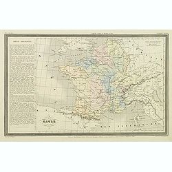
Gaule.
Finely engraved map prepared by A.H.Dufour and engraved by Giraldon-Bovinet. Published by Jules Renouard in his uncommon atlas "Le globe Atlas classique Universel de...
- $20 / ≈ €17
Date: Paris, Jules Renouard, ca.1840
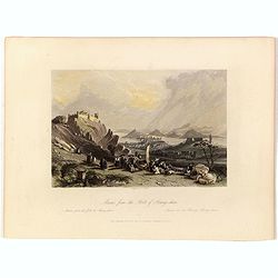
Macao from the Forts of Heang-shan.
A finely delineated view of the city of Macao as seen from one of its fortification areas. The foreground contains a group of religious worshipers. Engraved by S. Fisher....
- $150 / ≈ €127
Date: London, ca. 1840
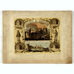
(Title page) Souvenir de Heidelberg.
Cover for a souvenir album with chromolithographed design and entitled: Souvenir de Heidelberg prepared by Louis Charles François. He emigrated with his family in May 17...
- $50 / ≈ €42
Date: Graimberg, Heidelberg, ca. 1840

Wallis's Guide for Strangers Through London.
Engraved plan with original hand-coloring, with title and alphabetical list of the principal streets below. Published by Edward Wellis 42 Skinner Street.With "An alp...
Date: London, E.Wallis, ca. 1840
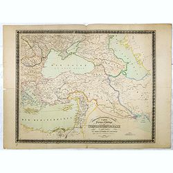
Carte physique et politique de la Turquie d'Europe et d'Asie contenant la Syrie, une partie de l'Egypte . . .
A detailed map including Turkey, Greece, Black Sea, Holy Land, Georgie, Iran, Iraq, Armenia.
Date: Brussels, 1840

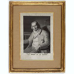
Joseph Acerbi.
Contemporary stipple engraved portrait of Giuseppe Acerbi (1773 – 1846) . Acerbi was an Italian explorer and naturalist, born in Castel Goffredo. In 1798 Acerbi travell...
- $175 / ≈ €149
Date: ca. 1840
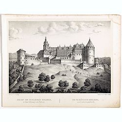
Ansicht der Heidelberger Schlosses. . .
Early lithograph published by Louis Charles François de Graimberg-Belleau. Lithographed by C.F Müller.French artist. Son of Gilles-François Belleau Graimberg. Louis Ch...
Date: Graimberg, Heidelberg, ca. 1840
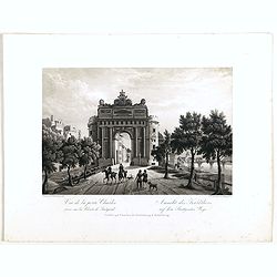
Vue de la porte Charles. . . Ansicht ded Karlthors . . .
Early aquatint after Louis Charles François de Graimberg-Belleau. Engraved by J.J Tanner.French artist. Son of Gilles-François Belleau Graimberg. Louis Charles Françoi...
Date: Graimberg, Heidelberg, ca. 1840
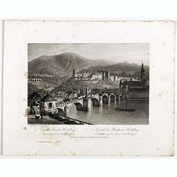
Vue du pont de Heidelberg. Ansicht der Brücke in Heidelberg.
Early aquatint after Louis Charles François de Graimberg-Belleau. Engraved by J.J Tanner.French artist. Son of Gilles-François Belleau Graimberg. Louis Charles Françoi...
Date: Graimberg, Heidelberg, ca. 1840
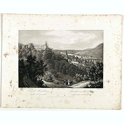
Vue de Heidelberg . . . Ansicht von Heidelberg . . .
Early aquatint after Louis Charles François de Graimberg-Belleau. Lithographed by J.J Tanner.French artist. Son of Gilles-François Belleau Graimberg. Louis Charles Fran...
Date: Graimberg, Heidelberg, ca. 1840
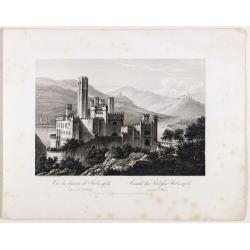
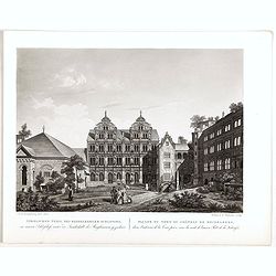
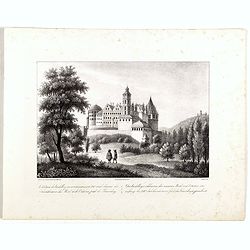
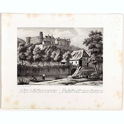
Vue du château de Stolzenfels . . . Ansicht des Schlofses Stolzenfels . . .
Early aquatint after Louis Charles François de Graimberg-Belleau. Lithographed by J.J Tanner.French artist. Son of Gilles-François Belleau Graimberg. Louis Charles Fran...
Date: Graimberg, Heidelberg, ca. 1840
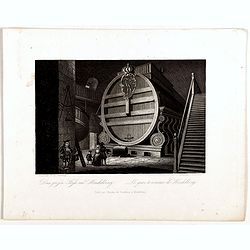
Das grofse Fafs au Heidelberg . Le gros tonneau de Heidelberg.
Engraving after Louis Charles François de Graimberg-Belleau. Engraved by J.J Tanner.French artist. Son of Gilles-François Belleau Graimberg. Louis Charles François emi...
Date: Graimberg, Heidelberg, ca. 1840
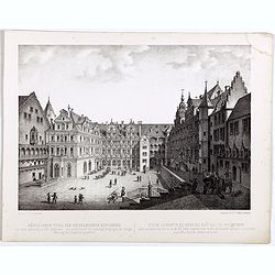
Nördlicher Theil des Heidelberg schlosses. Vue de la partie du nord du château de Heidelberg.
Early lithographs after Louis Charles François de Graimberg-Belleau. Lithographed by C.F Müller.French artist. Son of Gilles-François Belleau Graimberg. Louis Charles ...
Date: Graimberg, Heidelberg, ca. 1840
Nördlicher Theil des Heidelberger schlosses. . . Façade nord du château de Heidelberg . . .
Early aquatint after Louis Charles François de Graimberg-Belleau. Engraved by Hibon and F. Salathé.French artist. Son of Gilles-François Belleau Graimberg. Louis Charl...
Date: Graimberg, Heidelberg, ca. 1840
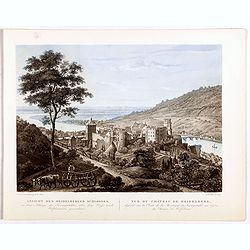
Vue du château et de la ville de Heidelberg . . . Ansicht des schlosses und der stadt Heidelberger . . .
Engraving after Louis Charles François de Graimberg-Belleau. Lithographed by Ch. Haldennvang.French artist. Son of Gilles-François Belleau Graimberg. Louis Charles Fran...
Date: Graimberg, Heidelberg, ca. 1840

Vue de la ville et du château de Heidelberg . . . Ansicht der stadt und des schlosses Heidelberger . . .
Engraving after Louis Charles François de Graimberg-Belleau. Engraved by Ch. Haldennvang.French artist. Son of Gilles-François Belleau Graimberg. Louis Charles Françoi...
Date: Graimberg, Heidelberg, ca. 1840

Vue du château de Heidelberg . . . Ansicht des Heidelberger schlosses . . .
Engraving after Louis Charles François de Graimberg-Belleau. Engraved by Charles Haldenwang.French artist. Son of Gilles-François Belleau Graimberg. Louis Charles Fran�...
Date: Graimberg, Heidelberg, ca. 1840
Ruines des batimens d' Adolphe et de Robert J au châteaude Heidelberg . . . Die ruinen des Adolfs und Rupruhtsbaues J auf dem Heidelberg . . .
Early lithography after Louis Charles François de Graimberg-Belleau. Lithographed by L. Faure.French artist. Son of Gilles-François Belleau Graimberg. Louis Charles Fra...
Date: Graimberg, Heidelberg, ca. 1840
Le châteaude Heidelberg au commencemment de XVIIe siecle. . . Das Heidelberg schlosse von den acusseren . . .
Early lithography after Merian. Lithographed by L. Faure.French artist. Son of Gilles-François Belleau Graimberg. Louis Charles François emigrated with his family in Ma...
Date: Graimberg, Heidelberg, ca. 1840
Le châteaude Heidelberg et ses environs . . . Das Heidelberg schlosse mit seinen umgebungen . . .
Early lithographs after Louis Charles François de Graimberg-Belleau. Lithographed by L. Faure.French artist. Son of Gilles-François Belleau Graimberg. Louis Charles Fra...
Date: Graimberg, Heidelberg, ca. 1840
Ansicht des Heidelberger schlosses . . . Vue du château de Heidelberg . . .
Early lithographs after Louis Charles François de Graimberg-Belleau. Lithographed by Salathé.French artist. Son of Gilles-François Belleau Graimberg. Louis Charles Fra...
Date: Graimberg, Heidelberg, ca. 1840
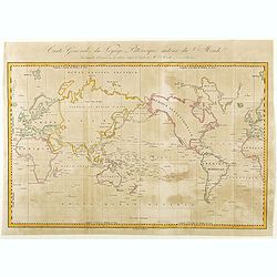
Carte Générale de Voyage Pittoresque Autour du Monde.
A map of the world centered on the Pacific Ocean. Engraved by Ambroise Tardieu.Jules Sébastien César Dumont d'Urville (1790 – 1842) was a French explorer, naval offic...
- $125 / ≈ €106
Date: Paris, ca. 1840
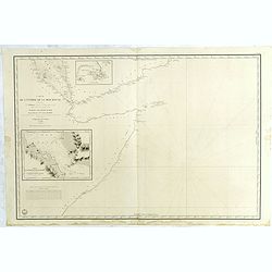
Carte de L'Entrée de la Mer Rouge. Dressée par M.Daussy. . .
Very large and detailed chart depicting the entrance of the Red Sea, including the coastline of Yemen with inset "Carte du détroit de Bab!el-Mandeb. . ." and &...
- $750 / ≈ €637
Date: Paris, ca. 1840
(Portrait of Joseph-Marie Jacquard).
A rare woven silk portrait of Joseph-Marie Jacquard after Bonnefonds, completed on the Jacquard punched-card loom. Woven by Carquillat in the silk factory of Didier Petit...
Date: France, ca. 1840
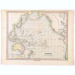
Oceana or Pacific Ocean.
A lovely detailed map of the Pacific, centered on Hawaii, from an early edition of Tanner's New Universal Atlas. From Russian America (AK) to Patagonia, and from New Zeal...
- $100 / ≈ €85
Date: Philadelphia, ca 1840
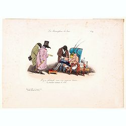
Les Metamorphoses du Jour. No.39
A humorous lithograph from the famous French caricaturist J-J. Grandeville. He drew scenes in which individuals with the bodies of men and faces of animals are made to pl...
Date: Paris, ca 1840
![Actualites. [News]](/uploads/cache/46547-250x250.jpg)
Actualites. [News]
A lithographic cartoon showing two tradesmen conversing. One says to the other: "Eh! Well jocker you're not working anymore!" "I have colic!" says the...
Date: Paris, ca 1840
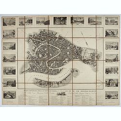
Pianta Topografica della R.a Città di Venezia con XIX de suoi principali prospetti.
A detailed town plan of Venice with an extensive key underneath and nineteen views of the important buildings among which: Piazza di S. Marco, Canal Grande, Tempio della ...
Date: Milan: Santo Vallardi, c.1840

Mœurs conjugales. Le trépas du caniche. Oh mon Dieu . . . (Plate 28)
Translation in English of title text: The Demise of the Poodle. - Oh my God, my God, is it possible?.... My poor Zozore, my joy, my consolation, I shall never see him aga...
Date: Paris, 30 september 1840
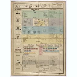
Histoire Sainte, 1840, Cours encyclopédiques - 28e Année - Méthode de Mr Colart . . .
Fine genealogic sheet for educational purpose, about Jewish history. From Adam to Cyrus. In top a map of "Palestine ou Terre Promise en 12 Tribes" 135 x 70mm.
- $350 / ≈ €297
Date: Paris, 1840
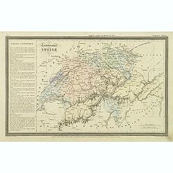
Confédération Suisse.
Finely engraved map of Switzerland prepared by A.H.Dufour and engraved by Giraldon-Bovinet. Published by Jules Renouard in his uncommon atlas "Le globe Atlas classiq...
Date: Paris, Jules Renouard, ca.1840
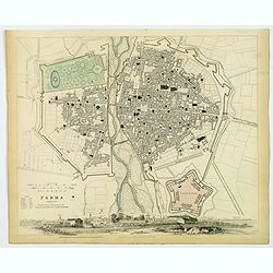
Parma..
A detailed plan of the Italian city of Parma, published by the Society for the Diffusion of Useful Knowledge. The city is divided into two parts by the Parma River. It de...
Date: London, 1840
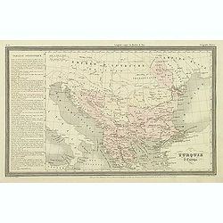
Turquie d'Europe.
Finely engraved map of Greece, Bulgaria, Romania, Albania and the east coast of the Black Sea, prepared by A.H.Dufour and engraved by Giraldon-Bovinet. Published by Jules...
Date: Paris, Jules Renouard, ca.1840
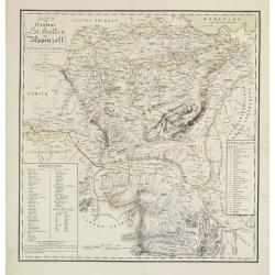
Karte der Kantone St.Gallen und Appenzell.
Scarce. A splendid map of the Swiss Alps, the area south west of the Boden See and west of the River Rhine, centered on Appenzell, St. Gallen.Prepared by Bernet and drawn...
Date: Zürich/ St.Gallen/ Bern, 1840
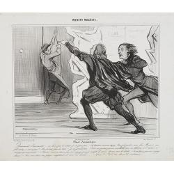
Farce dramatique. Doucement ! Doucement . . . Ne levez pas le rideau, je ne jous pas. . . - (Le Directeur accourant effrayé). Vous plaisantez, mon cher Macaire, vous plaisantez, n'est-ce pas ?. . . (Plate 8 from Robert Macaire.)
Second state. Translation in English of text title: Dramatic farce. - Gently! Gently!? Do not raise the curtain, I am not playing -(the frightened Director rushing toward...
Date: Paris, 1840 - 1841
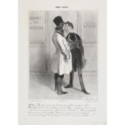
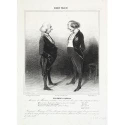
Robert Macaire. - Hé bien! mon cher directeur, ton affaire marche-t-elle? . . .
Plate from his famous series "Robert Macaire." This print has no plate number.Caption in English: (Robert): Well, well! My dear director… how's business? - (B...
Date: Paris, 1840-1841

Arabia. Sive Regio inter Mare Medium, Arabicum Sinum, . . .
Very detailed map of the Arabian Peninsular, covering the Caspian Sea in the upper right corner and Syria to the Indian Ocean, Somalia and parts of Persia, Syria and Kurd...
Date: London, 1841

Arabia.
Steel engraved map of the Arabian Peninsular. It shows Arabia and Parts of Persia, Syria and Kurdistan. The regional boundaries are colored and relief shown by hachures. ...
Date: London, 1841
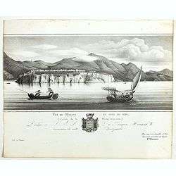
Vue de Monaco du côté du midi . . .
Extremely rare lithographed view of Monaco, lithographed by Jean Baptiste François Bosio, born June 17, 1764 in Monaco, and died July 6, 1827 in Paris, he was a French p...
- $1000 / ≈ €850
Date: Paris, 1841
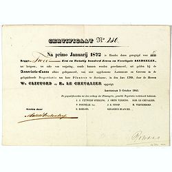
Certificaat N° 230
Text reads "Na primo januarij 1872 is houder dezes geregtigd voor 2/2147 tot hetgeen, ter zake van verjariing, zoude kunnen worden gereclmeerd, uiy gelden bij de Ass...
Date: Amsterdam, 1841
Robert Macaire. Règlement de comptes. Monsieur de Macaire . . . (Plate 5).
Translation in English of text title: SETTLEMENT OF ACCOUNTS. – Monsieur de Macaire, allow me to note that I find your accounts amazing. For a spy, who was charged to k...
Date: Paris, 1840-1841
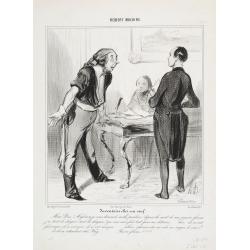
Robert Macaire. Inventaire chez un veuf. Mon Dieu! Messieurs . . . (Plate 9).
Translation in English of text title: Inventory at a widower's. My God, gentlemen, I must really apologize! Since the death of my poor wife I was so much in pain, so much...
Date: Paris, 1840-1841

Robert Macaire. Excellent Placement. Comment Ernest . . . (Plate 14).
Translation in English of text title: An excellent investment. - What do you mean, Earnest, you have 100'000 Francs and you don't want to give them to me, you must have l...
Date: Paris, 1840-1841
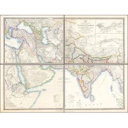
Map of the Countries lying between Turkey & Birmah, Comprising Asia Minor, Persia, India, Egypt & Arabia, and including the Black, Caspian & Red Seas 1841
This striking 4-sheet map, dating to the first half of the 19th century, covers a vast region stretching from Cyprus to Bhutan on the upper sheets and from Egypt to Thai...
Date: London, 1841
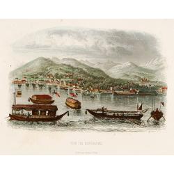
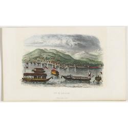
Vue de Nangasaki
View over the town from the water, identifying clearly Deshima with the V.O.C. trading post. Japanese sloops in the fore ground. Engraved by Alp.Boilly.
- $180 / ≈ €153
Date: Paris 1842
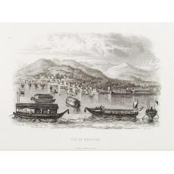
Vue de Nangasaki.
Steel engraved of Nagasaki from the water, identifying clearly Deshima, the V.O.C. trading post and the Dutch flag. Japanese and Chinese sloops in the fore ground. Engra...
- $125 / ≈ €106
Date: Paris, 1842
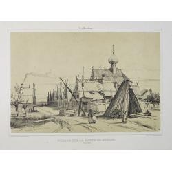
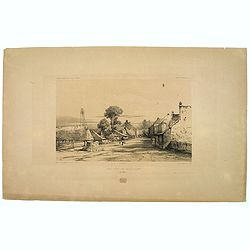
Village sur la route de Moscou. (9 Août 1839).
A view of a village on the way to Saint Petersburg on August 9 1839. Plate taken from the first illustrated account of Russian architecture. This publication was the proj...
Date: Paris, 1842
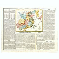
Geographical and Statistical Map of China. China and the Tributary Kingdom of Corea. For the Elucidation of Lavoisne's Genealogical, Historical, Chronological, & Geographical Atlas, by C. Gros, 1820. No. 64. Revised 1828.
Fine map of China and Korea, with a sub-title in top "Geographical and historical map of China.". The map is apparently a revised edition for 1828.The atlas was...
- $450 / ≈ €382
Date: London, 1842
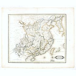
China.
This detailed map of China includes text giving measurements of "The Great Chinese Wall".The map was published in "Lizars' Edinburgh Geographical General A...
- $250 / ≈ €212
Date: Edinburg, 1842
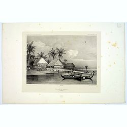
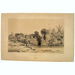
Village de Warrou.
Lithograph of the small settlement of Waru on the island of Seram in Indonesia. Plate 127, taken from the "Voyage au Pole Sud et dans L'Oceanie…." Departing i...
- $50 / ≈ €42
Date: Paris, 1842
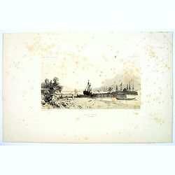
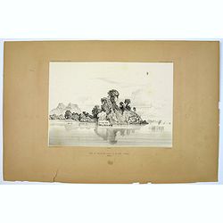
Rade d'Amboine.
A peaceful lithograph of ships and boats at anchor in Ambon Island, located in the archipelago of the Moluccas in Indonesia. Plate 108 taken from the 'Voyage au Pole et d...
- $35 / ≈ €30
Date: Paris, 1842
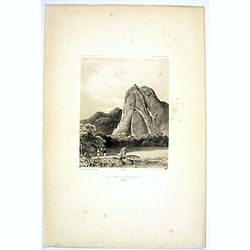
Montagne de la Manchiri.
Lithograph of the Montagne de la Manchiri in Papua New Guinea. It shows Breton, the artist on Dumont D'urville's voyage setting up a camera obscura in the foreground. Pla...
Date: Paris, 1842
Pecheurs de Tripang a la Baie Raffles.
Fine lithograph of Javanese fishermen in the Bay of Raffles. Located at the eastern end of the Cobourg Peninsula, Raffles Bay was the site of the second abortive attempt ...
Date: Paris, 1842
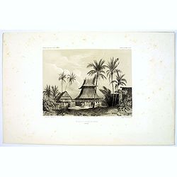
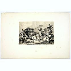
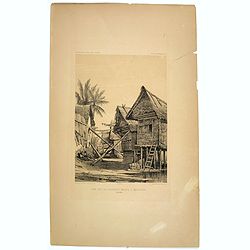
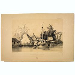
Mosquee du Village de Warou.
A lithograph of the mosque in the village of Waro, on the Indonesian island of Seram. Plate 128 taken from the 'Voyage au Pole et dans L'Oceanie…' Departing in late 183...
- $100 / ≈ €85
Date: Paris, 1842
Vue de Nangasaki
View over the town from the water, identifying clearly Deshima with Japanese sloops in the fore ground. Engraved by Alp.Boilly.
- $120 / ≈ €102
Date: Paris, 1842
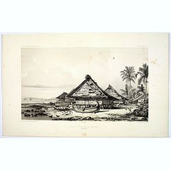
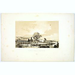
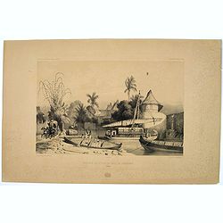
Rade et Village de Warrou.
An impressive lithograph of the dwellings to be found in the village of Waru, on the Indonesian island of Seram. Plate 126 taken from the 'Voyage au Pole et dans L'Oceani...
- $100 / ≈ €85
Date: Paris, 1842
Site sur la Cote de Sumatra.
A lovely lithograph of a small settlement somewhere along the coast of Sumatra. Plate 154 taken from the 'Voyage au Pole et dans L'Oceanie…' Departing in late 1837 in t...
- $100 / ≈ €85
Date: Paris, 1842
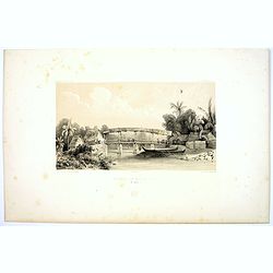
Riviere de Batou-Mera.
A lithograph of a simple bridge crossing the Batou-Mera river on the island of Ambone in the Moluccas, part of the Indonesian archipelago. Plate 110 taken from the 'Voyag...
- $100 / ≈ €85
Date: Paris, 1842
Une rue de Macassar.
A pretty lithograph of a street scene in the village of Makassar, on the southern edge of the Indonesian island of Sulawesi, formerly the Celebes Island. Plate 130 taken ...
- $30 / ≈ €25
Date: Paris, 1842
Une rue du Quartier Malais a Macassar.
An attractive lithograph of the Malay living quarters in the southern village of Makassar in Sulawesi, formerly the Celebes island in Indonesia. Plate 131 taken from the ...
- $30 / ≈ €25
Date: Paris, 1842
Case de Pecheurs dans la riviere Sambas.
A fishing hut seen along the Sambas River in Borneo. Plate 137 taken from the 'Voyage au Pole et dans L'Oceanie…' Departing in late 1837 in the Astrolabe and Zélée, D...
- $30 / ≈ €25
Date: Paris, 1842
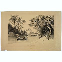
Canal de Samarang.
A tranquil lithograph showing a wealthy man being gently rowed up the canal in Semerang, on the Indonesian island of Java Plate 148 taken from the 'Voyage au Pole et dans...
- $50 / ≈ €42
Date: Paris, 1842
Site sur les bords du canal de Samarang.
A lithograph showing a Canalside scene of activity in the northeastern Javanese city of Semarang. Plate 149 taken from the 'Voyage au Pole et dans L'Oceanie…' Departing...
- $50 / ≈ €42
Date: Paris, 1842
Quartier Malais a Samarang.
A fine lithograph depicting the Malay quarter in the north eastern Javanese city of Semarang in Indonesia. Plate 150 taken from the 'Voyage au Pole et dans L'Oceanie…' ...
- $75 / ≈ €64
Date: Paris, 1842
Entrée de la Riviere de Paiou.
A lithograph showing the entrance to the river Paiou on Vanikoro Island, a part of the Santa Cruz Group and the Solomon Islands in the Pacific. Plate 97 taken from the 'V...
- $50 / ≈ €42
Date: Paris, 1842