Browse Listings

Paris fashion plate. (1213)
From Mode de Paris. Petit Courrier des Dames.. Underneath the print are the names of the shops where the clothing's, perfumes, porcelains, flowers, etc., depicted in the ...
Date: Paris 1835
![Sincapour. [Singapore]](/uploads/cache/23696-250x250.jpg)
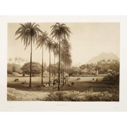
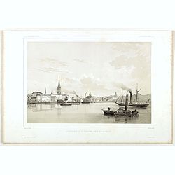
Sincapour. [Singapore]
Early view of Singapore after Pâris, engraved in aquatint by Sigismond Himely (1801-1872). The view is drawn looking up the Singapore River from South Boat Quay. It sho...
Date: Paris, Finot, 1835
Banjowangui.
Early view of Banjowangui on the island of Java. Engraved in aquatint technique by Sigismond Himely (1801-1872) after Lauvergne. Published as plate 61 in Voyage autour du...
- $150 / ≈ €127
Date: Paris, Finot, 1835
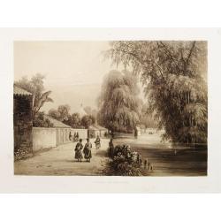
Rivière de Sourabaya.
Early view of Surabaya on the island of Java after Paris and engraved in aquatint technique by Sigismond Himely (1801-1872). Published as plate 61 in Voyage autour du mon...
- $300 / ≈ €255
Date: Paris, Finot, 1835
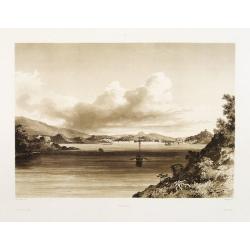
Macao.
Early view of Macao after Barthelemy Lauvergne (1805-1875) and engraved in aquatint technique by Sigismond Himely (1801-1872). Published as plate 28 in Voyage autour du m...
- $600 / ≈ €510
Date: Paris, Finot, 1835

Manuscript atlas.
Charming manuscript atlas with 6 maps, pen and ink and water color, showing France, Europe, Africa, Palestine, North America and South America.The atlas is done by a youn...
Date: France, 1835
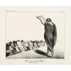
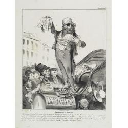
Athéniens prenez garde à Philippe ! (Démosthènes aux Athéniens). (Plate 454 in La Caricature)
A comedian dressed in a toga is warning the audience to beware of King Louis-Philip. The allusion is to Demosthenes (384-322 B.C.) warning the Athenians of the upcoming d...
Date: Paris, January 8, 1835

Siberia & Central Asia.
This map covers the eastern section of Russia as well as China, Japan, Korea, India and Tibet. The map is of interest for the use of Sea of Corea, the sea between Korea a...
Date: Boston, 1835
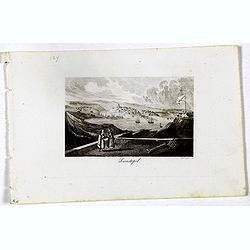
Alger Vue générale prise du port.
Decorative lithography taken from "Voyage pittoresque dans la régence d'Alger" printed in 1835 by Charles Motte. Prepared by WYLD William Wyld (1806-1889) and ...
- $40 / ≈ €34
Date: Paris, 1835
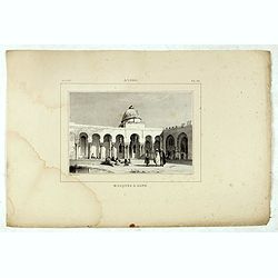
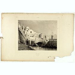
Alger, Mosquée à Bone.
Decorative lithography taken from "Voyage pittoresque dans la régence d'Alger" printed in 1835 by Charles Motte. Prepared by WYLD William Wyld (1806-1889) and ...
- $50 / ≈ €42
Date: Paris, 1835
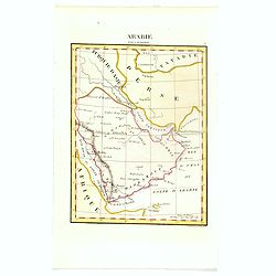
Arabie par A.M. Perrot.
Uncommon map of Arabia, prepared by A.M. Perrot and engraved by P Tardieu.More about Mapping of Arabia [+]
- $100 / ≈ €85
Date: Paris, 1835
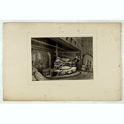
Alger, moulin arabe.
Decorative lithography taken from "Voyage pittoresque dans la régence d'Alger" printed in 1835 by Charles Motte. Prepared by WYLD William Wyld (1806-1889) and ...
- $50 / ≈ €42
Date: Paris, 1835
Alger, Baib-El-Oued.
Decorative lithography taken from "Voyage pittoresque dans la régence d'Alger" printed in 1835 by Charles Motte. Prepared by WYLD William Wyld (1806-1889) and ...
- $50 / ≈ €42
Date: Paris, 1835
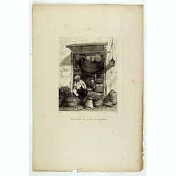
Alger, Marchand de la rue de Chartres.
Decorative lithography taken from "Voyage pittoresque dans la régence d'Alger" printed in 1835 by Charles Motte. Prepared by WYLD William Wyld (1806-1889) and ...
- $50 / ≈ €42
Date: Paris, 1835
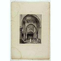
Alger, Mosquée rue de la percherie.
Decorative lithography taken from "Voyage pittoresque dans la régence d'Alger" printed in 1835 by Charles Motte. Prepared by WYLD William Wyld (1806-1889) and ...
- $50 / ≈ €42
Date: Paris, 1835
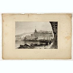
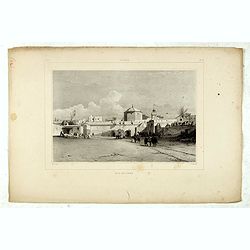
Alger.
Decorative lithography taken from "Voyage pittoresque dans la régence d'Alger" printed in 1835 by Charles Motte. Prepared by WYLD William Wyld (1806-1889) and...
- $50 / ≈ €42
Date: Paris, 1835
Alger, rue Bab-Azoun.
Decorative lithography taken from "Voyage pittoresque dans la régence d'Alger" printed in 1835 by Charles Motte. Prepared by WYLD William Wyld (1806-1889) and ...
- $50 / ≈ €42
Date: Paris, 1835
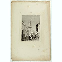
Sewastopol. (Sebastopol)
View of Sebastopol. Engraved by Leopold Zechmayer who was active in Vienna.
- $20 / ≈ €17
Date: Vienna, ca. 1835
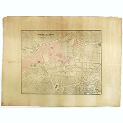
Quartier de Tivoli Nouveaux pereements de Rues.
Plan of the center of Paris showing Tivoli district with Madalene and Clichy. Lithography and pen and ink. Drawn in are the planned workshop of Serrurerie Théophile Mign...
Date: Paris, ca.1835
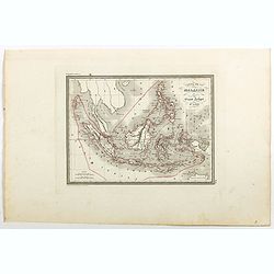
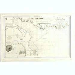
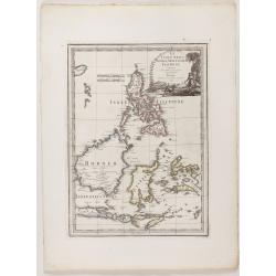
Carte de la Malaisie ou Grand archipel d'Asie.
Nice map of Indonesia, Philippines, Malacca with Singapore and tip of Northern Australia. Engraved by Thierry. Countries and regions in delicate out line color. Includes ...
Date: Paris, 1835
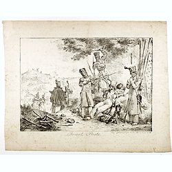
Avant poste.
Early lithography after François Grenier (1793–1867) and printed at lithographic printing shop of Charles Etienne Pierre Motte (1785-1836), active at rue des Marais, P...
Date: Paris, ca. 1835

Paris fashion plate. (1223)
From Mode de Paris. Petit Courrier des Dames.. Underneath the print are the names of the shops where the clothing's, perfumes, porcelains, flowers, etc., depicted in the ...
Date: Paris 1836
![[Title page] Atlas Départemental. . .](/uploads/cache/47742-250x250.jpg)
[Title page] Atlas Départemental. . .
Title page of La France et ses Colonies: Atlas Departemental, publié par Michel Fils ainé publishe by Andrieux & Barreswil in 1836. Drawn up by A. Lorrain, engraved...
- $150 / ≈ €127
Date: Paris, 1836
![Aou, Tōkei. Kokugun Zenzu [Atlas of Provinces and Counties of Japan]. (volume 1 only)](/uploads/cache/63619-250x250.jpg)
Aou, Tōkei. Kokugun Zenzu [Atlas of Provinces and Counties of Japan]. (volume 1 only)
First edition. Very attractive early Japanese Atlas of detailed maps of Japanese regions compiled by six Japanese civilians in the eighth year (1837) of the Tenpō era (...
Date: [Nagoya]: Tōheidō, Tenpō 8 = 1837

A-Na-Cam-E-Gish-Ca. A Chippeway Chief.
Half-length portrait of Anacamegishca, bare-chested, wearing a blanket and a peace medal. A-Na-Cam-E-Gish-Ca (1785-1862) - was a Chippewa (Ojibwe) Native American chief. ...
Date: Philadelphia, 1837

Ca-Ta-He-Cas-Sa-Black Hoof. Principal Chief of the Shawanoes.
Half-length portrait of Catahecassa wearing a dark colored jacked, grey vest, white shirt, and grey head scarf. A wonderful hand colored lithograph of Ca-Ta-He-Cas-Sa-Bl...
Date: Philadelphia, 1837

Major Ridge. A Cherokee Chief.
Head and shoulders portrait of Major Ridge,(1771-1839) wearing a blue jacket, gold or yellow vest, white shirt, and black cravat. A Cherokee Chief, who as a Cherokee lead...
Date: Philadelphia, 1837
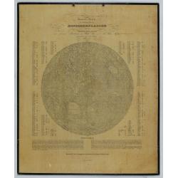
General-Karte der sichtbaren Seite der Mond-oberflaeche zugleich als Übersichts-Blatt zur grössern Mondkarte von Wilh. Beer und Joh: Heinr. Mädler.
An early representation of the viewable surface of the moon by Johann Heinrich Mädler (1794-1874) and Wilhelm Beer (1797-1850).Ignoring the occasional pre-telescopic ap...
Date: Berlin, 1837
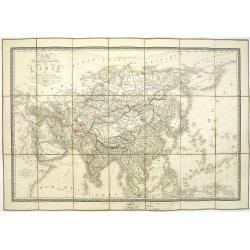
Carte physique et politique de l'Asie. Publiée pour la première fois en 1822 par J. GOUJON. Revue et augmentée par l'éditeur d'après de nouveaux matériaux.
This is a detailed map of Asie. It provides very good details of towns in modern-day Uzbekistan. The region is labeled as "Usbecs." The important cities on the...
Date: Paris, J. Goujon et J. Andriveau, 1837
![[Manuscript] Mappe - Monde - Novembre 1838.](/uploads/cache/23277-250x250.jpg)
[Manuscript] Mappe - Monde - Novembre 1838.
Fine manuscript double hemisphere world map. With an over sized Australia and no place names on the continents. With the signature of the author Suhardbetween the hemisph...
Date: Paris, 1838

Robert-Macaire renait de ses cendres. Par ma foi! La compagnie . . . (Published in Caricaturana, plate 21)
Second state. Translation in English of text title: Robert Macaire rising from his ashes. By heavens! The company is unlucky! . . . Yesterday I insured my super-glue plan...
Date: Paris, 1838
Messieurs et Dames! Les mines d'argent . . . (Plate 7 from Caricaturana)
Translation in English of text title: Ladies and gentlemen! Silver mines, gold mines, diamond mines are only thin gruel and stale rolls in comparison with coal . . . But ...
Date: Paris, 1838
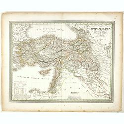
Das Osmanische asien oder die Asiatische Türkey. . .
Decorative map showing 'Asia Minor' with its neighboring countries. Prepared by Karl Ferdinand Weiland The eastern part of the Mediterranean Sea with Cyprus is as well sh...
- $200 / ≈ €170
Date: Weimar, 1836-1838
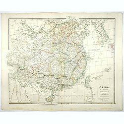
China.
Map of China, Taiwan and Korea. This map by the nephew of Aaron Arrowsmith first appeared in 1832 and was reissued several times. The present issue appeared in Arrowsmith...
Date: London, 1838
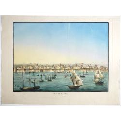
Vue de Cadix.
Very rare view of Cadiz and its seafront drawn and engraved by Renouard, published in Paris by Fatout et Avice, Quai Malaquais, 9. Beautifully hand colored at the time of...
- $2750 / ≈ €2337
Date: Paris, Fatout et Avice, Quai Malaquais 9 , c.1838
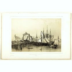
Pont de Knippelsbroe a Copenhague.
View of Knippelsbroe's bridge in Copenhagen. From "Voyage en Scandinavie, en Laponie, etc" - Atlas Pirtoresque (complément). Designed by A.Mayer.
Date: Paris, ca 1834-1838
Stockholm, 2e vue en panorama, prise sur le Velar.
Lithography on tinted grounds. View of Stockholm. From "Voyage en Scandinavie, en Laponie, etc" - Atlas Pirtoresque (complément). Designed by A.Mayer and litho...
Date: Paris, ca 1834-1838
Carta esférica del Rio de la Plata : desde su embocadura hasta Buenos Aires.
Large nautical chart illustrating the estuary formed by the combination of the Uruguay River and the Paraná River. It forms part of the border between Argentina and Ur...
Date: Madrid, 1812-1838

Carte du pays de Montenegro dressée d'après les opérations géodétiques . . .
Rare map of Montenegro prepared by Mr. le Comte Fedor de Karacsay (1787-1859) and engraved by Pietro Allodi. The title is in Russian, Arabic and French.In lower left corn...
Date: Vienna, ca. 1838
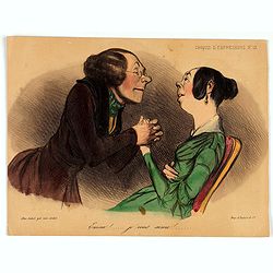
Croquis d'expression. Emma! ... je vous aime!... (Plate 13)
Emma!... I love you!... By Aubert gal. Vero-dodat. Printed by Imp. d'Aubert & Cie.CROQUIS D'EXPRESSIONS (Sketches of expressions) is a series of 55 lithographs by Da...
- $150 / ≈ €127
Date: Paris, 21 october 1838
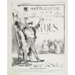
Société du Clystère. Robert Macaire philantrope. Vois-tu Bertrand . . . Caricaturana (Plate 2)
Translation in English of text title: Robert Macaire, philanthropist. You see, Bertrand... We are moralists in actions (play on words: actions means stocks). .... In acti...
Date: Paris, 1838
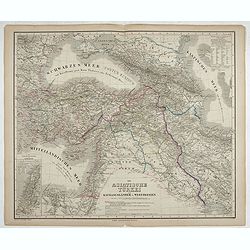
Die Asiatische Türkei. Die Kaukasusländer und West Persien.
Detailed map of Ottoman Asia or the Asian Turkey. Below the title a colored key to Turkish, Iran, Kurd, Caucasus and Russian possessions.Map prepared by H. Kiepert.
- $75 / ≈ €64
Date: Weimar, 1836-1838

Croquis d'expression. La maman - Est il gentil à manger son sucre d'orge . . . (Plate 31)
The mother: - Isn't he cute licking his barley sugar candy… one would think a young man of twenty years… He absolutely must become a lawyer!.Lithography published by ...
Date: Paris, 21 10 1838

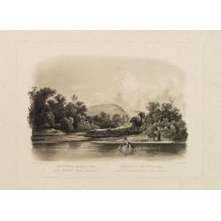
Forest scene on the Tobihanna Alleghany Mountains.
Original aquatint engraving for Travels in the Interior of North America between 1832-34 . Engraved by L.Weber. The finest work on American Indian life and the American F...
Date: London/Paris/Coblenz, 1839
Waschinga Sahba's Grab.. (Wakonda Creek.)
Original aquatint engraving for Travels in the Interior of North America between 1832-34 . Engraved by Ch. Vogel. The finest work on American Indian life and the American...
Date: London/ Paris/ Coblenz, 1839

1) Le Kakatoës à Huppe Jaune. 2) Le Lori Tricolor. Le Perroquet Vert.
Noteworthy bird print from 1839 Furne edition of the Histoire naturelle, générale et particulière by Georges-Louis Leclerc, Comte de Buffon.Engraved by Fournier after ...
Date: Paris, 1838 - 1839

1) Le Maïpouri. 2) Le Couroucou à Ventre Rouge. ID - à Ventre Jaune.
Noteworthy bird print from 1839 Furne edition of the Histoire naturelle, générale et particulière by Georges-Louis Leclerc, Comte de Buffon.Engraved by Fournier after ...
- $120 / ≈ €102
Date: Paris, 1838 - 1839

La Ara Rouge. Le Ara Bleu.
Noteworthy bird print from 1839 Furne edition of the Histoire naturelle, générale et particulière by Georges-Louis Leclerc, Comte de Buffon.Engraved by Pardinel after ...
- $150 / ≈ €127
Date: Paris, 1838 - 1839

Tailleur vous me demandez de l'argent, mais je n'en fais pas et je fais des portraits..... prenez ça c'est Mme votre épouse que j'ai faite de souvenir. (Plate 6 from Le Charivari, Scènes grotesques.)
Translation in English of title text: "Tailor, you ask for money, but I am a painter and I don't make money. Here, take this portrait of your wife. I drew it from me...
Date: Paris, November 29, 1839

Soyez donc poli. i.. impertinent!! (Leçon de Civilité puérile et honnète). (Plate 1 from the Charivari, Scènes grotesques)
Translation in English of title text: Be polite, you uneducated flail…(Lesson in juvenile civility and honest courtesy)..The old gentleman is slapping the young boy who...
Date: Paris, June 19, 1839
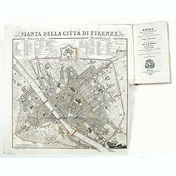
Guide de Florence et de ses environs Redige´ sur un plan entierement nouveau par l'Abbé A. Bulgarini et Traduit en français par A. Le Rendu. Deuxième édition.
Second edition. With 1 engr. folding plan (Pianta della Citta di Firenze. I. Balatri inc. e scris.) and 12 copper plates with views in Florence. The folding plan has meas...
- $550 / ≈ €467
Date: Florence, Gaspard Ricci, 1839
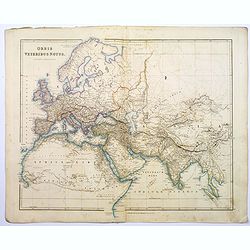
Orbis Veteribus Notus.
This is a detailed steel-engraved map of the ancient world, stretching from Europe eastwards to the Black Sea and beyond, southwards through northern Africa, Arabia, Indi...
Date: London, 1839
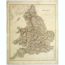
England.
A large and detailed steel engraved map of England, with each county divided by a different color. Many place names and physical features shown - it shows how densely pop...
Date: London, 1839
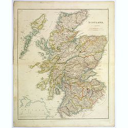
Scotland.
An attractive steel engraved map of Scotland, with each county divided by a different color. Many place names and physical features shown.The Arrowsmith family members we...
Date: London, 1839
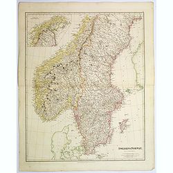
Sweden & Norway.
An attractive steel engraved map of Sweden & Norway. An inset map which is the continuation from Tornea to North Cape. Many place names and physical features shown.Th...
Date: London, 1839
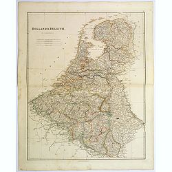
Holland & Belgium.
An attractive steel engraved map of Holland and Belgium. Map flanked by France and Prussia. Duchy of Luxembourg included. Many place names and physical features shown. 4 ...
Date: London, 1839
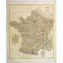
France.
A lovely, large steel engraved map of France, with an inset sketch of France divided into provinces, plus small inset map of the French Mediterranean island of Corsica . ...
Date: London, 1839
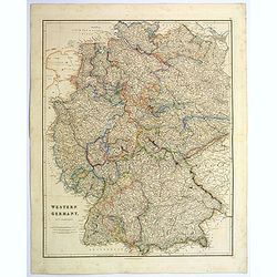
Western Germany.
A lovely, large steel engraved map of Western Germany. Some of the states engraved are: Holstein, Hannover, Mecklenburg, Saxony, Bavaria, Württemberg and Nassau. An extr...
Date: London, 1839
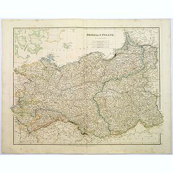
Prussia & Poland.
A glorious, large steel engraved map of Prussia and Poland. Some of the states covered are: Saxony, Pomerania, Posen, Brandenburg, Western & Eastern Prussia and the K...
Date: London, 1839
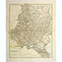
Russia & Poland.
A glorious, large steel engraved map of Russia and Poland. Covering Poland and Finland in the west, as far south as to the very edges of Persia, the Black sea, and to the...
Date: London, 1839
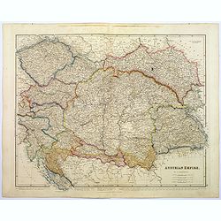
Austrian Empire.
A, large steel engraved map of the mighty Austrian Empire, covering Austria, Dalmatia, Styria, Slavonia, Hungary, Transylvania, Moravia and Bohemia. An enormous amount of...
Date: London, 1839
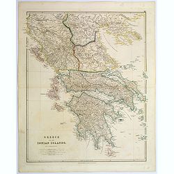
Greece and the Ionian Islands.
A large steel engraved map concentrating on Greece and the Ionian islands. Featured are Albania, Corfu, Macedonia, Central Greece and Morea., along with many small island...
Date: London, 1839
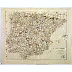
Spain & Portugal.
A large steel engraved map of European neighbours of Spain and Portugal. Including Balearic Islands, with a further inset map of Minorca. Numerous place names and physica...
Date: London, 1839
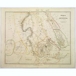
Nubia & Abyssinia.
A lovely looking steel engraved map of the portion of Africa that lies to the west of the Red sea. Mostly great deserts and the territories of nomadic African tribes are ...
Date: London, 1839
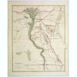
Egypt.
Quite a striking, large steel engraved map of Egypt. Following the course of the River Nile from Lower Egypt southwards to Upper Egypt, then crossing the border with Nubi...
Date: London, 1839
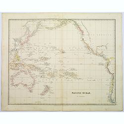
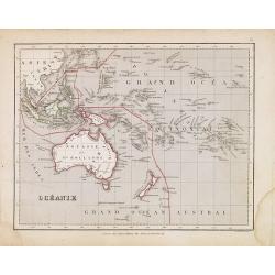
Pacific Ocean.
A wonderfully laid out map of the region, displaying the many island groups that make up this fascinating part of the world. The region is separated into parts, the South...
Date: London, 1839

Upper Canada &c.
A beautiful, large scale map of Upper Canada, and portions of the American states of New York, Ohio, and Pennsylvania. The province of 'Upper' Canada was created by the B...
Date: London, 1839
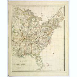
United States.
A lovely large map of the Untied States, as it was at the time of publication. Each state shown in a different outline color. Nothing is shown west of Louisiana, Arkansas...
Date: London, 1839
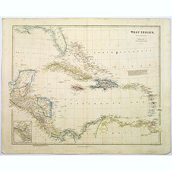
West Indies.
A fine, detailed steel engraved map comprising Florida, Bahamas, Cuba, Haiti, Jamaica, the Windward, and the Leeward Islands, the northern Columbian coastline, Panama, Gu...
Date: London, 1839
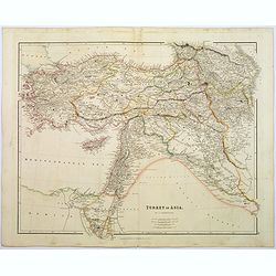
Turkey in Asia.
A lovely looking steel engraved map of Turkey in Asia. Map extent is Asia Minor, Syria, Holy Land, across to the Caucasian peoples that inhabit the lands between the Blac...
Date: London, 1839

La parte orientale dell' antico.. messico con la Florida..
A splendid two-sheet map of Mexico, including California, Arizona, New Mexico, part of Texas, Baja California and Mexico (west part) and of the Southeast Part of the US, ...
Date: Rome, Calcography, 1797-before 1839
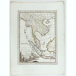
La Penisola delle Indie di la' dal Gange con parte delle Isole della Sonda delineate sulle ultima osservazioni.
Cassini’s splendid early map of Indochina, from Bangladesh in the west to central Borneo in the east, and southern China in the north, to Bali in the south. Good detail...
Date: Rome, Calcography, 1797-before 1839
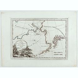
Le Coste Nord Ovest Dell'America e Nord Est dell'Asia Delineate sulle ultime Osservazioni del Cap. Cook
Cassini’s splendid early map of Cook's exploration of the Bering Strait, made on his Third and final voyage. The title is within a decorative title cartouche depicting ...
Date: Rome, Calcography, 1798-before 1839
Le Insole della Sonda
Cassini’s splendid early map of Philippines, and Indonesia..Taken from the ""Nuovo Atlante Geografico Universale delineato sulle ultime osservazioni", pu...
Date: Rome, Calcography, 1797-before 1839
Carte de la Partie Nord-Ouest de' l'Ile de Java. . . Pl. 33. N° 1086.
Sea chart depicting the north west part of the Island of Java, up to Batavia (present-day Jakarta). Also an inset chart of part of the Java coast line.Prepared by Clémen...
Date: Paris, 1839

Histoire et Statistique de la France ancienne et moderne, depuis le temps des Gaulois jusqu'à nos jours. Extrait des ouvrages chronologiques et statistiques de M. Arnault-Robert.
Very large time table of France with a wealth of historical information during the regimes of the Kings from Theodomir (418-420) until Louis XVI, until the Revolution and...
- $50 / ≈ €42
Date: Paris, c. 1839
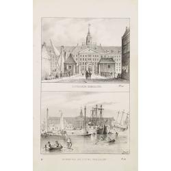
Oostindische Zeemagazijn. & De Werf van Het Oostind. Zeemagazijn.
Two decorative lithographies on one sheet, illustrating the V.O.C. East Indian Arsenal and the naval shipyard.
Date: Amsterdam, ca. 1840
!['S Lands Magazijn en Werf. [&] Het Oostindischehuis.](/uploads/cache/22713-250x250.jpg)
'S Lands Magazijn en Werf. [&] Het Oostindischehuis.
Two decorative lithographies on one sheet. View of the 'T Landts Magazyn , or 'Scheepvaartsmuseum' (Maritime Museum) on top. On the bottom the East Indian House , the hea...
Date: The Hague, 1840
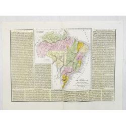
Impero Brasiliano . . .
A rare and detailed double-page map of Brazil. Map is surrounded by an explanatory historical text about the countries in a yellow background color.According to the title...
- $100 / ≈ €85
Date: Venice, 1840