Browse Listings
![.Taprobana Ins. Tabula XII Asiae. [Sri Lanka.]](/uploads/cache/27928-250x250.jpg)
.Taprobana Ins. Tabula XII Asiae. [Sri Lanka.]
Ptolemy's mythical island of Taprobana originally became associated with Sri Lanka although it was sometimes confused with Sumatra. Taprobana, as it was called on most ea...
Date: Lyons, M. Servetus, 1535

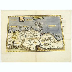
.Tabu nova partis Aphri.
This is Laurent Fries' 1535 edition of the earliest acquirable modern mapping of Africa north of the Equator.Based on Waldseemüller's map. The maps show Northern Africa ...
Date: Lyons, M. Servetus, 1535
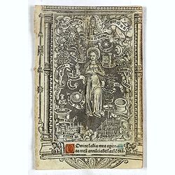
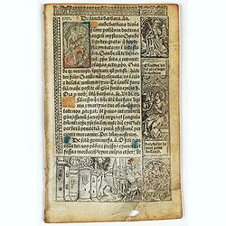
Leaf on vellum from a printed Book of Hours with miniature of the Virgin of the Litanies.
The full-page panel depicts The Virgin of the Litanies (120 x 77mm.) with 2 printed lines of text. The verso has 21 lines of printed text, surrounded by renaissance borde...
Date: Paris, Germain Hardouyn, c.1520-1540
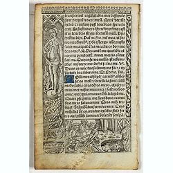
Leaf on vellum from a printed Book of Hours.
24 lines of printed text, surrounded by Renaissance borders decorated with flowers, vases, skeletons and religious scenes.From the press of the leading Parisian publisher...
Date: Paris, Germain Hardouyn, c.1520-1540
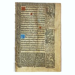
Leaf on vellum from a printed Book of Hours.
24 lines of printed text, surrounded by renaissance borders decorated with flowers, vases and religious scenes.From the press of the leading Parisian publisher and illumi...
Date: Paris, Germain Hardouyn, c.1520-1540
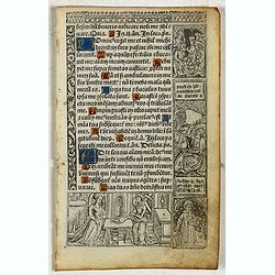
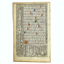
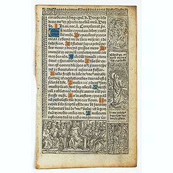
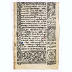
Leaf on vellum from a printed Book of Hours.
21 lines of printed text, surrounded by Renaissance borders decorated with flowers and little miniatures with figures on both sides.From the press of the leading Parisian...
Date: Paris, Germain Hardouyn, c. 1520-1540
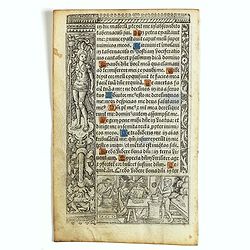
Leaf on vellum from a printed Book of Hours.
21 lines of printed text, surrounded by Renaissance borders decorated with flowers and little miniatures with figures on both sides.From the press of the leading Parisian...
- $125 / ≈ €106
Date: Paris, Germain Hardouyn, c. 1520-1540
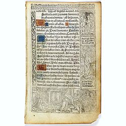
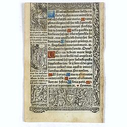
Leaf on vellum from a printed Book of Hours.
21 lines of printed text, surrounded by renaissance borders decorated with flowers, vases and religious scenes.From the press of the leading Parisian publisher and illumi...
- $125 / ≈ €106
Date: Paris, Germain Hardouyn, c.1520-1540
Leaf on vellum from a printed Book of Hours.
21 lines of printed text, surrounded by renaissance borders decorated with flowers, vases and religious scenes.From the press of the leading Parisian publisher and illumi...
- $125 / ≈ €106
Date: Paris, Germain Hardouyn, c.1520-1540
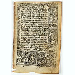
Leaf on vellum from a printed Book of Hours In Latin and French.
24 lines of printed text, surrounded by renaissance borders decorated with flowers, vases and figures. Gothic type, text in Latin, numerous one and two-line initials in g...
- $75 / ≈ €64
Date: Paris, Germain Hardouyn, c. 1520-1540
Leaf on vellum from a printed Book of Hours In Latin and French.
24 lines of printed text, surrounded by renaissance borders decorated with flowers, vases and figures. Gothic type, text in Latin, numerous one and two-line initials in g...
Date: Paris, Germain Hardouyn, c. 1520-1540
Leaf on vellum from a printed Book of Hours.
24 lines of printed text, surrounded by renaissance borders decorated with flowers, vases and religious scenes.From the press of the leading Parisian publisher and illumi...
- $125 / ≈ €106
Date: Paris, Germain Hardouyn, c.1520-1540
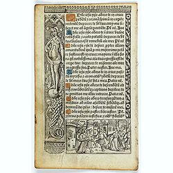
Leaf on vellum from a printed Book of Hours.
24 lines of printed text, surrounded by renaissance borders decorated with flowers, vases and religious scenes.From the press of the leading Parisian publisher and illumi...
Date: Paris, Germain Hardouyn, c.1520-1540
Leaf on vellum from a printed Book of Hours.
21 lines of printed text, surrounded by Renaissance borders decorated with flowers, vases and religious scenes.From the press of the leading Parisian publisher and illumi...
- $125 / ≈ €106
Date: Paris, Germain Hardouyn, c.1520-1540
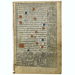
Leaf on vellum from a printed Book of Hours.
21 lines of printed text, surrounded by Renaissance borders decorated with flowers, vases and persons in Medieval dress.From the press of the leading Parisian publisher a...
- $125 / ≈ €106
Date: Paris, Germain Hardouyn, c. 1520-1540
Leaf on vellum from a printed Book of Hours.
21 lines of printed text, surrounded by Renaissance borders decorated with flowers and little miniatures with figures on both sides.From the press of the leading Parisian...
Date: Paris, Germain Hardouyn, c. 1520-1540
Leaf on vellum from a printed Book of Hours.
24 lines of printed text, surrounded by renaissance borders decorated with flowers, vases and religious scenes.From the press of the leading Parisian publisher and illumi...
Date: Paris, Germain Hardouyn, c.1520-1540
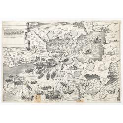
La dimostratione del luogo dove al presente sitrova l'armat di Barbarossa, et de Christiani detto il golfo dell 'Artha anti ch amente il sino ambracio…
The title cartouche at the top left reads: "La Dimostratione Del Luogo Dove Al Presente Sitrova L'Armat Di Barbarossa, et De Christiani Detto Il Golfo Dell' Artha An...
Date: Rome, c. 1540
![.[Pakistan, Afghanistan]](/uploads/cache/33849-250x250.jpg)
.[Pakistan, Afghanistan]
Wood block printed Ptolemaic map of the region of present-day Pakistan and part of Afghanistan. Convoluted mountain ranges and river systems dominate the trapezoidal map....
Date: Vienna, Trechsel, G., 1525 -1541
![.[Germany and Poland]](/uploads/cache/33862-250x250.jpg)
.[Germany and Poland]
Wood block printed map and one of earliest printed representation of Germany, Poland, The Low Countries, Austria and Switzerland prepared by Martin Waldseemüller. Based ...
Date: Vienna, Trechsel, G., 1525 -1541
![.[Bangladesh, Burma, India, Thailand]](/uploads/cache/33867-250x250.jpg)
.[Bangladesh, Burma, India, Thailand]
Wood block printed map and one of earliest printed representation of Bangladesh, Burma, India, Thailand prepared Martin Waldseemüller. Based on the slightly larger map f...
Date: Vienna, Trechsel, G., 1525 -1541
![[Albania, Bulgaria, Europe, Eastern, Greece, Hungary, Macedonia, Romania]](/uploads/cache/33868-250x250.jpg)
[Albania, Bulgaria, Europe, Eastern, Greece, Hungary, Macedonia, Romania]
Wood block printed map and one of earliest printed representation of Albania, Bulgaria, Europe, Eastern, Greece, Hungary, Macedonia, Romania prepared Martin Waldseemülle...
Date: Vienna, Trechsel, G., 1525 -1541
![[Arabian Peninsula]](/uploads/cache/33869-250x250.jpg)
[Arabian Peninsula]
Wood block printed map and one of earliest printed representation of the Arabian Peninsula prepared by Martin Waldseemüller. Based on the slightly larger map from 1513 p...
- $2200 / ≈ €1870
Date: Vienna, Trechsel, G., 1525 -1541
![.[Georgia (Republic), Sarmatia, Ukraine]](/uploads/cache/33870-250x250.jpg)
.[Georgia (Republic), Sarmatia, Ukraine]
Wood block printed map and one of earliest printed representation of Georgia (Republic), Sarmatia, Ukraine prepared by Martin Waldseemüller. Based on the slightly larger...
Date: Vienna, Trechsel, G., 1525 -1541
![[East Asia]](/uploads/cache/33873-250x250.jpg)
[East Asia]
Wood block printed map and one of earliest printed representation of East Asia and centered on Amenia, prepared Martin Waldseemüller. Based on the slightly larger map fr...
Date: Vienna, 1525 -1541
![.[India]](/uploads/cache/33861-250x250.jpg)
.[India]
Wood block printed map and one of earliest printed representation of India prepared by Martin Waldseemüller. Based on the slightly larger map from 1513 published in &quo...
Date: Vienna, Trechsel, G., 1525 -1541
![[India and China]](/uploads/cache/33875-250x250.jpg)
[India and China]
Wood block printed map and one of earliest printed representation of India and China prepared Martin Waldseemüller. Based on the slightly larger map from 1513 published ...
Date: Vienna, 1525 -1541

Tabula Sexta Asia (Arabian Peninsula)
This is a very desirable early Ptolemaic woodblock map of the Arabian Peninsula, here called Arabia Felix. The map is presented on a trapezoidal projection with par...
Date: Vienna, 1525 -1541
![.[Balkan region with Austria, Croatia, Slovenia, Switzerland, etc]](/uploads/cache/33858-250x250.jpg)
.[Balkan region with Austria, Croatia, Slovenia, Switzerland, etc]
Wood block printed map and one of earliest printed representation of Balkan with Austria, Croatia, Slovenia, Switzerland, etc prepared Martin Waldseemüller. Based on the...
Date: Vienna, 1525 -1541
.Aphricae Tabula secunda continet.
An important early map of the northern coast of Africa and including parts of the islands of Sicily and Sardine.
Date: Vienne, 1541
![[Taprobana - Sri Lanka]](/uploads/cache/33847-250x250.jpg)
[Taprobana - Sri Lanka]
Wood block printed map and one of earliest printed representation of Ceylon prepared Martin Waldseemüller.Based on the slightly larger map from 1513 published in "P...
Date: Vienna, Trechsel, G., 1525 -1541
![.[Near east with Cyprus]](/uploads/cache/33857-250x250.jpg)
.[Near east with Cyprus]
Wood block printed map and one of earliest printed representation of Near east with Cyprus prepared by Martin Waldseemüller. Based on the slightly larger map from 1513 p...
Date: Vienna, 1525 -1541

Tabula nova utriusque Indiae.
This is the fourth and last edition of this map based on Waldseemüller's first "modern" map of Asia. It follows that cartography without change but adds an int...
Date: Vienne, 1541
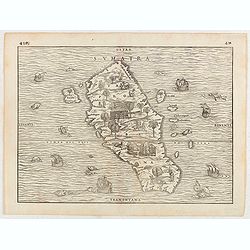
![Tabula XII - Asiae [Taprobana Ins - Ceylon/Sri Lanka]](/uploads/cache/40249-250x250.jpg)
Tabula XII - Asiae [Taprobana Ins - Ceylon/Sri Lanka]
Map of Taprobana (Sri Lanka) which depicts the typical misconceptions of Ptolemy showing the island greatly enlarged, surrounded by imaginary islands, and with a small pa...
Date: Vienne, 1541

Tabula Superioris Indiae & Tartariae maioris. (Modern Map of China, Japan, etc.)
Important map extending from Tartary in the north, to "Prov. Bocat" (Cambodia) in the south. "Tebet" is shown prominently, as is "Zinpangri"...
Date: Vienne, 1541
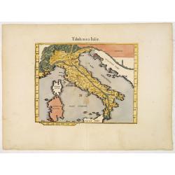
.Tabula nova Italiae. (Modern Italy)
Wood block printed modern map of Italy, prepared by Lorenz Fries and one of the earliest modern maps of Italy and environs. Based on the slightly larger map from 1513 pub...
Date: Vienna, 1525 -1541
![[Europe, Eastern, Sarmatia, Ukraine]](/uploads/cache/33854-250x250.jpg)
[Europe, Eastern, Sarmatia, Ukraine]
Wood block printed map and one of the earliest printed representations of European Sarmatia, generally the region between the Baltic and Black Sea and Sea of Azov. Includ...
Date: Vienna, Trechsel, G., 1525 -1541
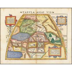
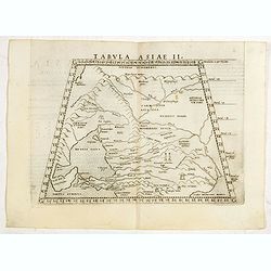
Tabula Asiae VII.
Attractive woodblock map, depicting the Caspian Sea, Black Sea and the Persian Gulf, extending to the Imaus Mountains. according to Ptolemy. In the center of the map is...
Date: Basle, 1542
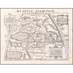
Tabula Asiae VII.
Attractive woodblock map, depicting the Caspian Sea, Black Sea and the Persian Gulf, extending to the Imaus Mountains. according to Ptolemy. In the center of the map is...
Date: Basle, 1542
![[Map of Turkey]](/uploads/cache/31502-250x250.jpg)
[Map of Turkey]
Page with an early representation of Turkey with Cyprus and Syria. This text page with a fine wood block printed map is from the rare work "C. Iulii Solini Polyhisto...
- $275 / ≈ €234
Date: Basle, Michael Isengrin, 1544
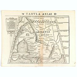
Tabula Asiae II (Black Sea and Caspian Sea)
The first edition of Munster's map of Ukraine and the region north of the Black Sea, based upon Claudius Ptolemy which appeared in his "Geographia Universalis",...
- $500 / ≈ €425
Date: Basel, Heinrich Petri, 1545
Tabula Asiae II (Black Sea and Caspian Sea).
The first edition of Münster's map of Ukraine and the region north of the Black Sea, based upon Claudius Ptolemy which appeared in his "Geographia Universalis"...
- $400 / ≈ €340
Date: Basel, Heinrich Petri, 1545
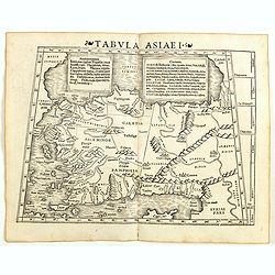
Tabula Asiae I (Turkey)
The first edition of Munster's map of Turkey, based upon Claudius Ptolemy which appeared in his "Geographia Universalis", first published in 1540. The Geographi...
- $500 / ≈ €425
Date: Basel, Heinrich Petri, 1545
![Tabula Asiae III [Black & Caspian Sea Region]](/uploads/cache/41831-250x250.jpg)
Tabula Asiae III [Black & Caspian Sea Region]
Attractive woodblock Ptolemaic map, depicting Armenia and in the Right part of the Caspian Sea with Noes Arch, believed to have come to rest in a mountain in Armenia acco...
Date: Basel, Heinrich Petri, 1545
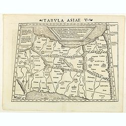
Tabula Asiae V. (Persia)
The first edition of Munster's map between the Persian Gulf and the Caspian Sea, extending from Armenia and Mesopotamia eastward, based upon Claudius Ptolemy which appear...
- $300 / ≈ €255
Date: Basel, Heinrich Petri, 1545
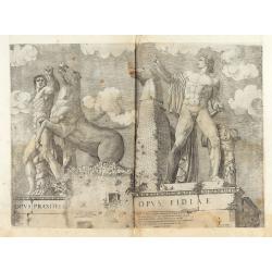
Opus Praxitelis, Opus Fidiae.
Opus Praxitelis, Opus Fidiae [Work of Praxiteles, Work of Fidias]. With the Lafreri's imprint and date. Published in the "Speculum Romanae Magnificentiae" (The ...
Date: Rome, Antonio Lafreri, 1546
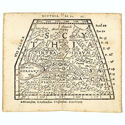
Scythia.
Woodblock engraved map covering the region between the Caspian and the Sea of China, much of which is Terra Incognita in the North and East. In 1546 Honter’s Cosmograph...
- $190 / ≈ €161
Date: Zürich, 1546
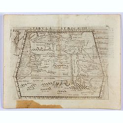
Tabula Africae IIII.
Gastaldi's map of Northern Africa, based on Ptolemy. Showing all of the Mediterranean, the Ethiopian Interior, the Red Sea, Egypt, the source of the Nile, the Dead Sea, e...
- $400 / ≈ €340
Date: Venice, 1548
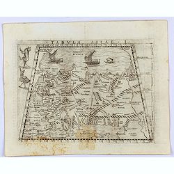
Tabula Asiae I.
Gastaldi's map of Asia Minor and the Bosporus Straits, based upon Ptolemy.It is one of the earliest obtainable maps of the region .From Giacomo Gastaldi's Atlas of 1548 w...
- $400 / ≈ €340
Date: Venice, 1548
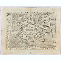
Tabula Europae II. (Spain and Portugal)
Gastaldi's map showing Spain and Portugal, based upon Ptolemy.It is one of the earliest obtainable maps of the region.From Giacomo Gastaldi's Atlas of 1548 which has been...
- $375 / ≈ €319
Date: Venice, 1548

Tabula Asiae IIII. (Cyprus, Holy Land, Syria, Jordan, Iraq)
Gastaldi's map showing Cyprus, the Holy Land, Syria, Jordan and Iraq, based upon Ptolemy's map It is one of the earliest obtainable maps of the region.From Giacomo Gastal...
- $350 / ≈ €297
Date: Venice, 1548
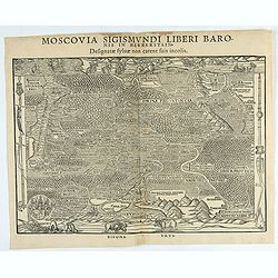
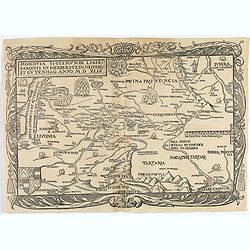
Moscovia Sigismundi Liberi Baronis In Herberstein, Neiperg et Gutehnag Anno M.D XLIX
First Modern Map of Russia. A rare and important cornerstone map for Russia collections.Sigismund von Herberstein made two visits to Russia. In 1517-18 he travelled as a ...
Date: Vienna, 1549
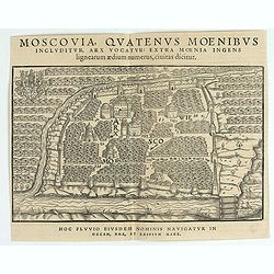
Moscovia Sigismundi Liberi Baronis In Herberstein, Neiperg et Gutehnag Anno M.D XLIX
The forst modern plan of Moscow. A rare and important cornerstone map for Russia collections.Sigismund von Herberstein made two visits to Russia. In 1517-18 he travelled ...
Date: Vienna, 1549
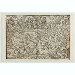
Typus Universalis Terrae, Iuxta Modernorum Distinctionem Et Extensionem Per Regna Et Provincias.
Rare world map from Gregor Reisch's Magarita Philisophica published in Basle in 1583.In 1544, Peter Apian incorporated a world map into his Cosmographia, based upon Gemma...
Date: Antwerp c.1550

Della Graecia Ritratto di Costantinopoli hora stanza del Turco.
Early bird's eye view of Constantinople. From an Italian text edition of S. Münster's Cosmographia, which is a short and complete summary of Renaissance knowledge.
Date: Basle, 1550
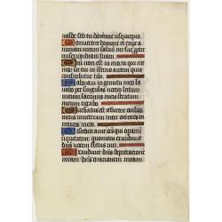
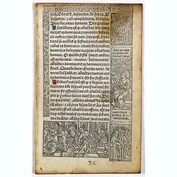
Leaf on vellum from a manuscript Book of Hours.
RECTO: Six 1-line initials in liquid gold on colored grounds and five line-fillers in same.VERSO: Five 1-line initials in liquid gold on colored grounds and one 2-lines i...
Date: France, 1520-1550
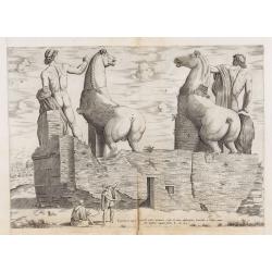
Equitum in Quirinali, aversa parte, marmorei colossi Romae; absolutissima Praxitelis et Fidiae manu.
Back view of the Dioscuri (or horse tamers, or Alexander and Bucephalus), formerly attributed to Pheidias and Praxiteles, with two figures nearby, one seated on a stone, ...
Date: Rome, Antonio Lafreri, 1550
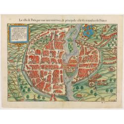
La ville de Paris, par tout tant renommée & principalle ville du royaulme de France.
Very early birds-eye view of Paris. From his Cosmographia, that great compendium of Renaissance knowledge. An exciting print.Engraved by Hans Rudolf Manuel-Deutsch(1525-1...
Date: Bâle, H. Petri, 1552
![[Lot of 6 leaves] Civitas Augustana olim Vindelica…/Sueviae et Bavariae Descriptio/ Franckfordiae ad Oderam imago…/Franckofordianae civitatis…/Erdfordia magnifica …Thuringoru urbs…Fuldensis civitatis… / Lubecum una ex praeclarioribus. . .](/uploads/cache/48258-250x250.jpg)
[Lot of 6 leaves] Civitas Augustana olim Vindelica…/Sueviae et Bavariae Descriptio/ Franckfordiae ad Oderam imago…/Franckofordianae civitatis…/Erdfordia magnifica …Thuringoru urbs…Fuldensis civitatis… / Lubecum una ex praeclarioribus. . .
Six text leaves with wood block printed views and maps of Augsburg, Frankfurt /Oder, Frankfurt am Main, Erfurt and Fulda, Lübeck and a map of Swabia and Bavaria. From th...
Date: Basel, 1552
![[Lot of 205 leaves of Germany, Austria, Switzerland, Alsace and Brabant].](/uploads/cache/48263-250x250.jpg)
[Lot of 205 leaves of Germany, Austria, Switzerland, Alsace and Brabant].
205 text leaves illustrated with views and maps relating to Germany, Austria, Switzerland, Alsace and Brabant from the 1552 Latin text edition of Münster's Cosmographia...
Date: Basel, 1552

[Lot of 9 leaves with maps and views of Persia and Arabia).
Nineteen text leaves with wood block illustrations relating to Persia and Arabia, from the 1552 Latin text edition of Münster's Cosmographia, which is a short and comple...
Date: Basel, 1552
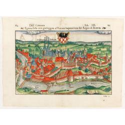
Dell Germania Egrana.
Early woodcut view of the city of Egra (Cheb) in the Czech Republic. From the 1552 Latin text edition of Münster's Cosmographia, which is a short and complete summary of...
Date: Basel, 1552
![[Lot of 2 leaves] Rubeaquum cum arce Isenburgo…/ Wyssenburg…](/uploads/cache/48269-250x250.jpg)
[Lot of 2 leaves] Rubeaquum cum arce Isenburgo…/ Wyssenburg…
Two wood block printed early bird's-eye views of Rouffach (lies along the Alsatian wine route) and Wissembourg (Alsace). From the 1552 Latin text edition of Münster's Co...
Date: Basel, 1552
![[Lot of 2 leaves] Vienna Austriae metropolis, urbs…](/uploads/cache/48268-250x250.jpg)
[Lot of 2 leaves] Vienna Austriae metropolis, urbs…
A wood block printed early panoramic view of Vienna (Austria). From the 1552 Latin text edition of Münster's Cosmographia, which is a short and complete summary of Renai...
Date: Basel, 1552
![[Lot of 25 leaves of France, Brabant, Netherlands, Luxemburg]](/uploads/cache/48264-250x250.jpg)
[Lot of 25 leaves of France, Brabant, Netherlands, Luxemburg]
Twenty-five text leaves with wood block illustrations relating to France, Brabant, the Netherlands, Luxemburg. From the 1552 Latin text edition of Münster's Cosmographia...
Date: Basel, 1552
![[Lot of 10 leaves] Catalogus doctorum…in Cosmographia Sebastiani…/ Index Cosmographicus.](/uploads/cache/48294-250x250.jpg)
[Lot of 10 leaves] Catalogus doctorum…in Cosmographia Sebastiani…/ Index Cosmographicus.
Ten leaves with several wood blocks with index taken from the "Cosmographia". From the 1552 Latin text edition of Münster's Cosmographia, which is a short and ...
Date: Basel, 1552
![[Lot of 7 leaves] Curiensis civitas, Rhetorum…/Valesia/Solothurensis/Clarissimae civitatis/Genevensis/Basiliensis/Ursina…Bernensis/Sedunensis/Designatio …Badensis.](/uploads/cache/48278-250x250.jpg)
[Lot of 7 leaves] Curiensis civitas, Rhetorum…/Valesia/Solothurensis/Clarissimae civitatis/Genevensis/Basiliensis/Ursina…Bernensis/Sedunensis/Designatio …Badensis.
Seven text leaves illustrated with wood block bird's-eye views of Chur, Solothurn, Geneva, Basel, Bern, Sitten, Baden and one single sheet map of the Valais. From the 155...
Date: Basel, 1552
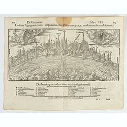
Colonia Agrippina civitas…
A wood block printed early panoramic view of Cologne (Germany). A lettered key A-Z beneath the view. The 1552 Latin text edition of Münster's Cosmographia is a short and...
- $70 / ≈ €59
Date: Basel, 1552
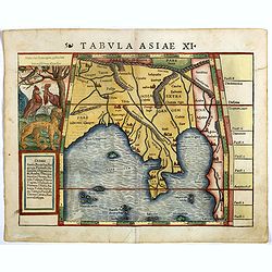
Tabula Asiae XI.
Attractive early woodblock map of the Indian Ocean, extending from Southeast Asia to the Ganges River and north to the Himalayas.In upper left inset panel of tiger, cocke...
- $600 / ≈ €510
Date: Basle, H. Petri, c. 1552
![[Lot of 5 leaves] Noerdlinga civitas imperialis…/ Nemetum civitatis…Spiram appellant / Situs & figura… Trevirensis / Situs civitatis Confluentinae… / Civitas Lunaeburgensis…](/uploads/cache/48259-250x250.jpg)
[Lot of 5 leaves] Noerdlinga civitas imperialis…/ Nemetum civitatis…Spiram appellant / Situs & figura… Trevirensis / Situs civitatis Confluentinae… / Civitas Lunaeburgensis…
Five text leaves with woodblock-printed early bird's-eye views of Nördlingen, Speyer, Trier, Koblenz, and Lüneburg, from the 1552 Latin text edition of Münster's Cosmo...
Date: Basel, 1552
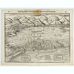
Lindoiae civitas insularis, undique aqua lacunari circunsusa.…
A wood block printed early bird's-eye view of Lindau on Lake Constance (Germany). A lettered key A-O in the plate. From the 1552 Latin text edition of Münster's Cosmogra...
- $70 / ≈ €59
Date: Basel, 1552
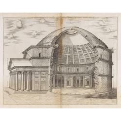
Panthei Fidelissime Dimensi Exterior et Interior…
The print features the Pantheon in Rome, broken away to show the interior. Complete title : " Panthei Fidelissime Dimensi Exterior et Interior pars ex antiquo romano...
Date: Rome, Antonio Lafreri, 1553
Sumatra.
Gastaldi prepared this map and it was the first separate map of any Southeast Asian island based on actual observation. The general contour of Sumatra is remarkably good ...
Date: Venice, 1556
Moscovia Sigismundi Liberi Baronis In Herberstein, Neiperg et Gutehnag Anno M.D XLIX
First Modern Map of Russia. A rare and important cornerstone map for any Russian collection.One of two maps of Russia compiled by Herberstein, who was ambassador from the...
Date: Basle, 1556
![[Toscana / Tuscany] En, candidi lectores, elegantioris Italiae partis, Tusciae scilicet, topographiam. aenis nris formis excussam in hac Tabella vobis denuo damus. . .](/uploads/cache/47717-250x250.jpg)
[Toscana / Tuscany] En, candidi lectores, elegantioris Italiae partis, Tusciae scilicet, topographiam. aenis nris formis excussam in hac Tabella vobis denuo damus. . .
A rare map of Tuscany, including the islands of Elba, Giglio, Giannutri and part of Corsica, and covering the whole of Tuscany, part of Liguria, Lombardy, Emilia, Umbria,...
- $5000 / ≈ €4249
Date: Rome, ca 1557
![[Sea monsters] De regni Settentrionali Monstri marini & terrestri…](/uploads/cache/49169-250x250.jpg)
[Sea monsters] De regni Settentrionali Monstri marini & terrestri…
Münster's plate of monsters of both land and sea, taken from an Italian text edition of Münster's Cosmographia, which is a short and complete summary of Renaissance kno...
Date: Basel, 1558
![Amphitheatri Veronen[sis] diligens et accurata delineatio…](/uploads/cache/49136-250x250.jpg)
Amphitheatri Veronen[sis] diligens et accurata delineatio…
The print features the Amphitheater of Verona, it comes from "Speculum Romanae Magnificentiae" (The Mirror of Roman Magnificence). Example of the first state of...
- $900 / ≈ €765
Date: Rome, Antonio Lafreri, ca. 1560
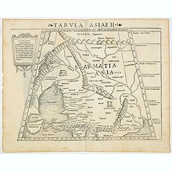
Tabula Asiae II.
Scarce FIRST edition of this map of the ancient region of Asiatic Sarmatia - now Southern Russia and part of Ukraine, around the Azov seaGirolamo Ruscelli's edition of Pt...
- $300 / ≈ €255
Date: Venice, 1561
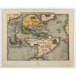
Die neüwen Inseln/ so hinder Hispanien gegen Orient bey dem land Indie ligen.
The earliest and one of the most important separate maps to show both Americas. Although it was not the first map to use “America” as a designation for the New World,...
Date: Basle 1561
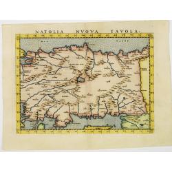
Natolia nuova tavola.
Uncommon first edition of this early map of Turkey.Girolamo Ruscelli's edition of Ptolemy's Geographia included newly engraved copperplates by Giulio and Livio Sanuto. Th...
- $375 / ≈ €319
Date: Venice, 1561