Search Listings matching "valentijn"
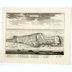
Platte Grond vande Stadt Macao.
A fine view of the city of Macao from Lappa Island showing in schematic blocks the structure of the town. With European vessels and junks in the surrounding water. With n...
Date: Amsterdam, 1724
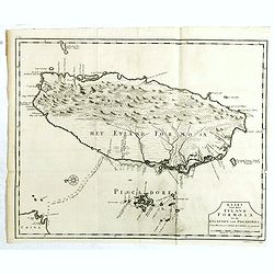
Kaart van het Eyland Formosa en de Eylanden van Piscadores.
The earliest printed map of Taiwan or Formosa. Oriented to the east, with north at the left, covering the entire island and the nearby Pescadores, now known as the Penghu...
Date: Amsterdam, 1724
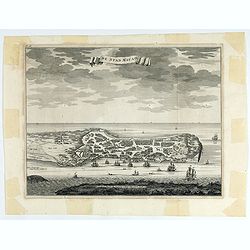
De Stad Macao.
A fine view of the city of Macao from Lappa Island showing the defenses, the forts, churches and convents: including Fort de Baare, Bon Parto, Fort St Paulo (Monte Fort)....
Date: Amsterdam, 1724
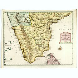
Nieuwe Kaart van Choromandel ende Malabar. . .
Fine map depicting the southern part of India and the northern tip of Ceylon. Much detail is given along the coastlines, settlements and principal coastal features are id...
- $550 / ≈ €480
Date: Amsterdam, 1726
Haven van Aquapulco in ' Coninkryk van Nova Spagnien in de Zuyd Zee.
A finely engraved plan of the harbor, fort and village of Acapulco drawn from a hilltop vantage point looking out to sea. Several galleons are pictured approaching or anc...
- $500 / ≈ €437
Date: Amsterdam, 1726
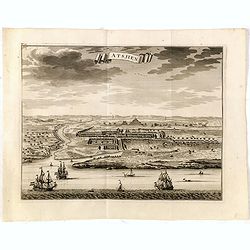
Astjien.
Nice bird's eye-view of the Town of Atjien on the northernmost point of Sumatra by François Valentijn (1666-1727), a missionary, who worked at Amboina from 1684 to 1694 ...
- $225 / ≈ €197
Date: Amsterdam, 1726
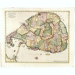
Nieuwe kaart van het Eyland Ceylon. . .
Fine map depicting the Island of Ceylon/Sri Lanka, oriented with north to the left.. Good interior detail is given with settlements, roads, etc. An attractive early map, ...
- $850 / ≈ €743
Date: Amsterdam, 1726
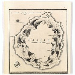
Makjan Geheel Bergagtig.
The island of Makian in Indonesia (formerly the Dutch East Indies) is represented on this map as a mountainous Möbius strip around a giant donut hole. François Valentij...
- $150 / ≈ €131
Date: Amsterdam, 1726

Nieuwe Kaart van het Eyland Sumatra..
Fine chart depicting the Island of Sumatra and the southern coasts of Malaysia from Quedo to Johore. North is orientated to the left of the page. Singapore is probably id...
Date: Amsterdam, 1726

Nieuwe Caart der Eylanden van Banda.
Decorative map of the Banda Islands. Until the mid-19th century the Banda Islands were the world's only source of the spices nutmeg and mace, produced from the nutmeg tre...
Date: Amsterdam, 1726
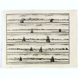
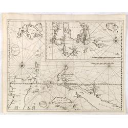
De Kust van Nova Guinea tot aan deze bogt . . .
De kust van Nova Guinea tot aan deze bogt.De Kust van Nova Guinea ofte Salomon Sweers hoek. Het Landt van Nova Guinea in de Groote Bocht daar wy vergeefs hoopten een doo...
Date: Amsterdam, 1726
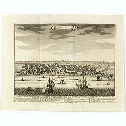
Samboepo in platte Grond.
Decorative panoramic view of the town of Samboupo on the island of Celebes (Sulawesi) in today's Indonesia. Dutch (V.O.C.) sailing ships and various local craft fill the ...
- $150 / ≈ €131
Date: Amsterdam, 1726
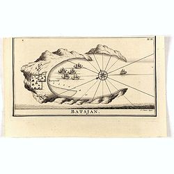
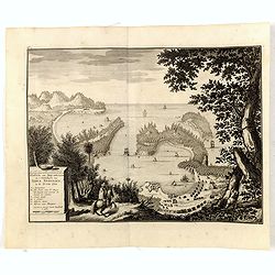
Batsjan. (Bacan)
Decorative panoramic view of Bay with the Dutch fortress Barneveld at the island of Bacan in today's Indonesia. Dutch (V.O.C.) sailing ships are illustrated.François Val...
- $45 / ≈ €39
Date: Amsterdam, 1726
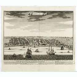
Samboepo in platte Grond.
Decorative panoramic view of the town of Samboupo on the island of Celebes (Sulawesi) in today's Indonesia. Dutch (V.O.C.) sailing ships and various local craft fill the ...
- $150 / ≈ €131
Date: Amsterdam, 1726
De Landvoogdy der Moluccos met de Aangrenzende Eylanden . . .
Two charts on one sheet depicting the Moluccas islands. Little interior detail is given but the coastlines, settlements and principal coastal features are identified. To ...
Date: Amsterdam, 1726
