Search Listings matching "sea-chart"

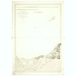
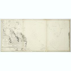
Carte de la Baye et du Port de Trinquemalay dans L'Isle de Ceylan.
Chart showing the bay of Trincomalee, Ceylon (Sri Lanka). Trincomalee is natural deep water port on the east coast of Sri Lanka, about 110 miles northeast of Kandy. It is...
- $250 / ≈ €217
Date: Paris, 1775
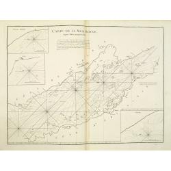
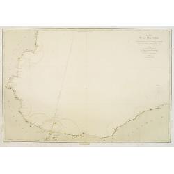
Carte de la Mer Rouge, depuis Moka jusqu'a Gedda.
Chart of the Red Sea. With 3 inset maps of Shake Omare, Goofs and Gedan.D'Après De Mannevillette (1707-1780) was one of France's first hydrographers. When the first edit...
- $450 / ≈ €390
Date: Paris, 1775
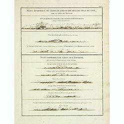
Vues diverses du fort de l'Agouade pres de l'isle de Goa . . . Sumatra . . .
French sea sea chart with 9 coastal views near Goa in India and Sumatra. The titles above the main profiles reading as following : Vues diverses du fort de l'Agouade pre...
- $200 / ≈ €174
Date: Paris, Brest, Demonville, 1775
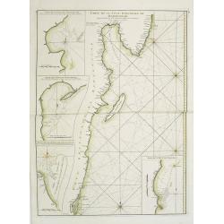
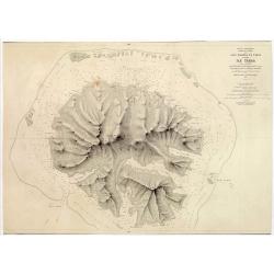
Carte Orientale de Madacascar Depuis la Rivière Ivondrou jusqu'à Mananzari.
Large sea sea chart of the southeast coastline of Madagascar and four inset maps of the harbors and anchorage of Tamatave, Foulpointe, Teintingue und Veninguebe. Inset ma...
- $125 / ≈ €108
Date: Paris, Brest, chez Demonville, 1775
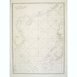
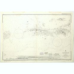
A chart of the China Sea inscribed to Monsr. D'APRES de MANNEVILLETTE .. To A.Dalrymple.
Most important milestone sea chart is based upon the surveys made from navigational surveys by Alexander Dalrymple (1737-1808]. He was the first Hydrographer of the Briti...
Date: Paris, ca. 1775

Carte de la Baye et du Port de Trinquemalay Dans L'Isle de Ceylan.
French chart of the harbor of Trinquemalay on the island of Ceylon. Prepared after Samuel Cornish who was a vice admiral for the English East India company.Latitude and l...
- $350 / ≈ €304
Date: Paris, Brest, chez Demonville, 1775

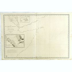
Carte Réduite Des Côtes Orientales De L' Amérique Septentrionale Contenant Partie du Nouveau Jersey.. Virginie.. Georgie..
Uncommon chart that extends from Delaware Bay and Philadelphia south through much of Georgia to Island Amelia and St. Johns River. Fleur-de-lis and rhumb lines fill the s...
Date: Paris, 1778

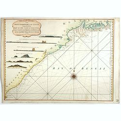
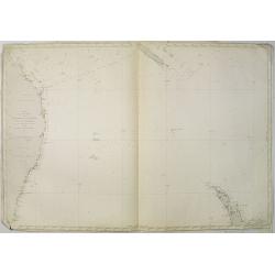
A chart of the northern part of the Indian Ocean..
Chart of the northern part of the Indian Ocean, including part of Arabia, India and Sri Lanka prepared by D'Apré de Mannevillette and published in London by Laurie and W...
- $750 / ≈ €651
Date: London 1794
The Coast of India, from Point Gordeware to the Ganges Comprehending Part of the Coast of Golconda . . .
Detailed sea chart of the coast of India, from the mouths of the Ganges Rivers in the northeast to Point Gordeware in the south west. Includes numerous sailing channels a...
- $400 / ≈ €347
Date: London, 1794
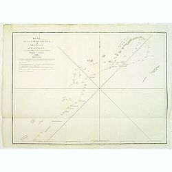
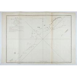
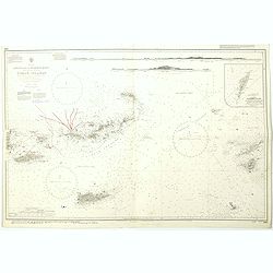
Plan de la partie des iles, ou archipel de Coree, vue au mois de Mai 1787 par les Fregates Francaises la Boussole et l'Astrolabe. . . .
Showing the track of La Pérouse along the southern most tip of Korea, with Quelpaerts Islands (now-a-days called Jeju, with the vulcano Halla-san (Halla Mountain) clearl...
- $400 / ≈ €347
Date: L'Imprimerie de la Republique, An V, 1797

Carte des découvertes fautes en 1787 dans les Mers de Chine et de Tartarie par les Frégates Françaises la Boussole et l'Astrolabe. . . ée. Feille.
La Pérouse's important large-scale of Northern Japan, Hokkaido, the Kuriles, the tip of Kamschatka, and the northern part of Korea.Showing the track of Perouse from 27 ...
Date: Paris, 1797
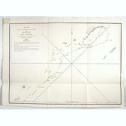
Plan de la partie des iles, ou archipel de Coree, vue au mois de Mai 1787 par les Fregates Francaises la Boussole et l'Astrolabe. . . .
Showing the track of La Perouse along the southernmost tip of Korea, with Quelpaerts Islands (nowadays called Jeju, with the volcano Halla-san (Halla Mountain) clearly no...
- $450 / ≈ €390
Date: L'Imprimerie de la Republique, An V, 1797
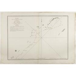
Plan de la partie des Isles ou Archipel de Corée.
Showing the track of La Perouse along the southern most tip of Korea, with Quelpaerts Islands (now-a-days called Jeju, with the volcano Halla-san (Halla Mountain) clearly...
Date: Paris, 1797
Plan de la partie des Isles ou Archipel de Coree.
Showing the track of La Perouse along the southernmost tip of Korea, with Quelpaerts Islands (nowadays called Jeju, with the vulcano Halla-san (Halla Mountain) is clearly...
Date: Paris, 1797

Plan of part of the islands or archipellago of Corea seen in May 1787 by the Boufsole and Astrolabe.
This is a representing the visit of the French Admiral and explorer, le Comte de La Pérouse to Korea in 1786. The tracks of La Perouse are shown.From 'Atlas du Voyage d...
Date: London, 1798

Carte des côtes du Golfe du Mexique compris entre la pointe sud de la presqu'Ile de la Floride et la pointe nord de la presqu'Ile d'Yucatan:...
Detailed and important early chart of the Gulf Coast and Florida and dated 1800. First French edition of "the first printed [map] to show and name Galveston Bay&qu...
Date: Paris, 1800/1803

Carte Réduite Du Golphe Du Mexique Et Des Isles De L' Amérique..
A well engraved and highly detailed chart prepared by Bellin of the Gulf of Mexico and the Caribbean. In addition to a magnificent title cartouche and a color key to the ...
Date: Paris dated year 17, or 1808

Manuscript plan of Havana harbour.
Manuscript chart with good nautical detail and soundings of Havana harbour.
Date: Spain c.1820

Eastern passage to China. sheet 1.
James Horsburgh early chart of the coasts of Java, Bali, Lombok, with part of Sulawesi, and Borneo. Insets of "Sketch of Bally Strait", Sketch of Lombock Strait...
- $2500 / ≈ €2169
Date: London, 1824
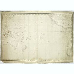
Carte générale de l'océan pacifique. . .
depicting the Pacific Ocean, with nice detail of Hawaii. With a complete outline for Australia and Tasmania. Shows the south east Asian region and South America.Mapping ...
Date: Paris, 1833
Carte de L'Entrée de la Mer Rouge. Dressée par M.Daussy. . .
Very large and detailed chart depicting the entrance of the Red Sea, including the coastline of Yemen with inset "Carte du détroit de Bab!el-Mandeb. . ." and &...
- $750 / ≈ €651
Date: Paris, ca. 1840

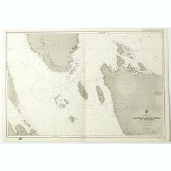
Kaart van de Gaspar Straaten volgens opnemingen van J.Stolze, D.Ross, enz.
Very large and rare chart centered on the strait between Bangka's southeastern seacoast and Belitung's western shores.Short front views of the coastal relief are shown in...
Date: Amsterdam 1843

Straat Riouw onder opzicht van de commissie tot verbetering der Indische Zeekaarten..
Very large and rare so-called Blue Back centered on the strait passing between the Riau Islands. It contains an inset map with enlarged details of Riouw Harbor on Bintang...
Date: Amsterdam 1843

Kaart van een gedeelte van de Noord Kust van Java en Straat Sunda van Tanjong Kaik tot den vierden hoek bij Anjer..
Very large and rare chart depicting Java's northern seacoast.Coastal profiles are present at the bottom of the map.The chart is prepared by B.H.Staring, J.A.G.Rietveld an...
Date: Amsterdam 1843-1844

Straat Sunda en Westkust van Java.
Very large and rare chart depicting Java's western seacoast close to the Sunda Strait.Showing part of Sumatra on top and the West Java tip, today hosting the Ujung Kulon ...
Date: Amsterdam (1841)1846

Kaart van de Reede van Batavia met de verschillende vaarwaters naar dezelve trigometrisch opgenomen op last van deb schout bijnacht E.Lucas.
Very large and rare so-called blue-black chart centered on Jakarta's harbor.The chart is prepared by B.G.Escher, I.A.C. Eschauzier, B.H.Staring and E.H.Boom during an exp...
Date: Amsterdam (1841) 1847
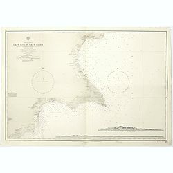
Cyprus south east coast Cape Kiti to Cape Eloea.
An British Admiralty chart of Cyprus south east coast. A highly corrected version of Admiralty chart 971 originally published 15th February 1866 under the Superintendence...
- $100 / ≈ €87
Date: London, 1852

Kronstat From The Russian Survey . . .
Scarce chart of the Island of Kronstat, the primary defensive position for the Russian Navy in defense of Russia's Czarist Capital of St. Petersburg.Published on the eve ...
- $500 / ≈ €434
Date: London, 1853
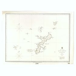
North Pacific Ocean LOO CHOO and adjacent Islands 1855.
Large scale chart of Okinawa in the Japan Sea. With scale and vignette of Typographical office. Map nr. 2416.An interesting note in lower right "The coast line of al...
- $300 / ≈ €260
Date: London, 1855
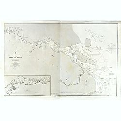
China, Sheet IX, Yang-Tse-Kiang from the sea to Nanking . . .
A fine, large-scale chart. This chart depicts the last stretch of the Yangtse River before it meets the sea. It gives soundings and notes on the tides, and includes an in...
- $750 / ≈ €651
Date: London, 1843-1859
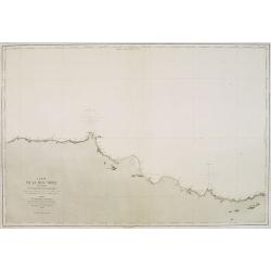
Carte de la Mer Noire. (5e Feuille). Du Cap Zefiros au Cap Kerempeh. . .
Very detailed chart of the Turkish part of the Black Sea including the towns of Sinop, Samsun, etc. Showing soundings in meters, lighthouses are marked with yellow and re...
Date: Paris, 1860
![Red Sea - Strait of Jubal.. [2838]](/uploads/cache/23496-250x250.jpg)
Red Sea - Strait of Jubal.. [2838]
Large chart focused on the Strait of Jubal in the Gulf of Suez. With the Juzur Tawilah Islands at the center and an inset plan of the Tur Harbour (At Tur, South Sinai) o...
- $500 / ≈ €434
Date: London (1853) corrected for 1862

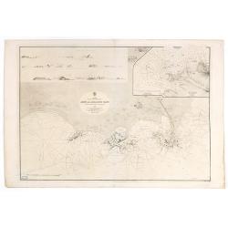
Plan de la rade de Macao (chine) Levé d'après les ordres mr. Rocquemaurel.
Very detailed chart of Macao and several of the surrounding Islands, and features numerous depth soundings throughout. Prepared by captain, Gaston de Rocquemaurel. Logo o...
Date: Paris, c.1856 / 1863
![(2 charts of Shri Lanka) Mer des Indes - Ile de Ceylan - Partie Nord. Détroit de Palk et Golfe de Manaar.. [with] Partrie Sud...](/uploads/cache/23493-250x250.jpg)
(2 charts of Shri Lanka) Mer des Indes - Ile de Ceylan - Partie Nord. Détroit de Palk et Golfe de Manaar.. [with] Partrie Sud...
Two very large charts representing the northern and southern part of Sri Lanka and giving details about the Indian seacoast around the Gulf of Mannar and the Palk Strait....
- $750 / ≈ €651
Date: Paris, 1866
Arabia. Gulf of Aden - North Coast. Aden and Adjacent Bays..
Large chart focused east of Aden, in Yemen. With inset plan of Aden Anchorage in the upper right corner and a set of coastal profiles in the upper left corner.With latitu...
- $900 / ≈ €781
Date: London (1836) corrected to 1868

North Pacific.
Huge three sheet so-called Blue-back sailing chart of the Northern Pacific including China, Korea (with Matu Is. and Liancourt), Japan, Philippines, Kamchatka, Hawaii, Al...
Date: London, 1868

Carte générale de la mer des Indes dressée par P. Daussy et P.E. Wissocq, grave par Chassant, ecrit par J.M. Hacq.
Magnificent and detailed large-scale chartdepicting the Indian ocean, with east coast of Africa, Madagascar, Arabian Peninsula, India, China, etc .Including the West coa...
- $1000 / ≈ €868
Date: Paris, 1837-1869
Carte de la Mer Noire. (1e Feuille). Du Bosphore à Mangalia et du Bosphore au Cap Kerempeh.
Very detailed chart of the Turkish part of the Black Sea including the towns of Constantinople (Istanbul) , Bourgas. Showing soundings in meters, lighthouses are marked w...
Date: Paris, 1860, updated for 1870
![Bay of Bengal, compiled chiefly from government survey.. [2 sheets]](/uploads/cache/23495-250x250.jpg)
Bay of Bengal, compiled chiefly from government survey.. [2 sheets]
Large scale chart in 2 sheets focused on the Bay of Bengal.It covers Sri Lanka, the whole Indian eastern coast, the seacoast of Bangladesh, Myanmar and Thailand as far as...
- $1200 / ≈ €1041
Date: London (1863), corrections to 1871
![[2 Sheets] Carte Générale de l'Océan Pacifique Dressée Par Mr. C. A. Vincendon-Dumoulin. . . Pl. 1. N° 1092. / Ocean Pacifique Feuille 2. . . Pl. 2. N° 1093.](/uploads/cache/26731-250x250.jpg)
[2 Sheets] Carte Générale de l'Océan Pacifique Dressée Par Mr. C. A. Vincendon-Dumoulin. . . Pl. 1. N° 1092. / Ocean Pacifique Feuille 2. . . Pl. 2. N° 1093.
Two sea charts depicting the Pacific Ocean, with nice detail of Hawaii. Sheet 1 shows the south east Asian region. The second North America and part of South America. Pre...
- $900 / ≈ €781
Date: Paris, 1845, updated for 1884
Océan Pacifique. Archipel de la Société. Iles Raiatea et Tahaa. 1ère Feuille. Ile Tahaa..
Large scale chart focused on the island Tahaa, in French Polynesia.Showing a few details of the village of Tahaa, banks, isles and soundings made in meters. Relief is sho...
- $200 / ≈ €174
Date: Paris, 1885
Carte de la Mer comprise entre l'Australie, la Nelle. Zélande et la Nelle.
Sea chart of the Pacific Ocean between Australia, New Zealand and New Caledonia. Including the towns of Sydney, Brisbane. The northern tip of New Zealand in lower right c...
- $350 / ≈ €304
Date: Paris, 1872 updated for 1888
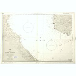
Carte particuliere de la cote septentrionale d'Afrique. (13eme feuille)
A fine French Service Hydrograhique de la Marine chart no. 3424, showing Cape Rose and Cap Nègre, in Algeria, drawn in 1873 by E. Mouchez, updated to 1913. Chart engrave...
- $80 / ≈ €69
Date: Paris, 1873 / 1913
![Environs de Raguse (Dubrovnik). Deuxième Feuille. Canal de Calamota (Kolocep).. [277]](/uploads/cache/23473-250x250.jpg)
Environs de Raguse (Dubrovnik). Deuxième Feuille. Canal de Calamota (Kolocep).. [277]
This large-scale coastal chart shows the stretch of the Dalmatian coast between Slano as far as the island of Kolocep, the southernmost inhabited island in Croatia. With ...
- $200 / ≈ €174
Date: Paris [1877] corrected to 1932
![Mer Adriatique. Côte Orientale. De l'Ile Meleda à Antivari.. [3552]](/uploads/cache/23471-250x250.jpg)
Mer Adriatique. Côte Orientale. De l'Ile Meleda à Antivari.. [3552]
This large scale coastal chart shows the stretch of Dalmatian coast between the island Mljet in Croatia as far as Ulcinj (Montenegro). With latitude and longitude scales,...
- $200 / ≈ €174
Date: Paris [1877] corrected to 1934
![Mer Adriatique. Partie Sud.. [3976]](/uploads/cache/23549-250x250.jpg)
Mer Adriatique. Partie Sud.. [3976]
This large scale coastal chart centered on the southern part of the Adriatic sea. Showing the Dalmatian coast between Split in Croatia as far as the northernmost tip of C...
- $200 / ≈ €174
Date: Paris [1883] updated for 1935
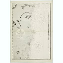
Sheet VI East coast of Australia. New South Wales Tacking Point to Coffs Islands surveyed by Comr. Fredk. W. Sidney R.N. . . 1862 - 1864. . .
Large chart representing East coast of Australia with New South Wales including Tacking Point to Coffs Islands surveyed by Comr. Fredk. W. Sidney R.N. from 1862 - 1864. F...
- $150 / ≈ €130
Date: London, 1939-1942
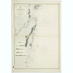
East coast of Australia. New South Wales. Sheet VII, Coffs Islands to Evans Head surveyed by Comr. Fredk. W. Sidney R.N. assisted by E.P. Bedwell & J.T. Gowlland, Masters & S. Guy, 2nd Master R.N. 1864-5
Large chart representing East coast of Australia with New South Wales including Coffs Islands to Evans Head surveyed by Comr. Fredk. W. Sidney R.N. First published at the...
- $150 / ≈ €130
Date: London, 1907-1943
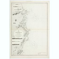
Sheet V East coast of Australia. New South Wales Evans Head to Danger Pt. surveyed by Comr. Fredk. W. Sidney R.N. . . 1864-5. . .
Large chart representing East coast of Australia with New South Wales including Evans Head to Danger Pt. surveyed by Comr. Fredk. W. Sidney R.N. from 1864 - 1865. First p...
- $150 / ≈ €130
Date: London, 1866-1943
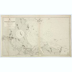
Australia - East coast Queensland Keppel Bay and Islands surveyed by staff Commr. J.Jeffery. . . 1864. . .
Large chart representing East coast of Australia with Queensland including Keppel Bay and Islands surveyed by Comr. J.Jeffery in 1864. First published at the Admiralty 3r...
- $150 / ≈ €130
Date: London, 1866-1943
Sheet XII East coast of Australia Queensland Keppel Isles to Percy Isles. . .
Large chart representing east coast of Australia's Queensland showing Keppel Isles to Percy Isles with relief shown by hachures, spot heights and bathymetric soundings. S...
- $150 / ≈ €130
Date: London, 1932-1944
![Australia, E. coast - Queensland Percy isles to Whitsunday I. chiefly from a joint Admiralty & Colonial survey by Staff Commander Bedwell, R.N. 1873 to 1879 [1945]](/uploads/cache/36212-250x250.jpg)
Australia, E. coast - Queensland Percy isles to Whitsunday I. chiefly from a joint Admiralty & Colonial survey by Staff Commander Bedwell, R.N. 1873 to 1879 [1945]
Large chart representing East coast of Australia with Queensland from Percy isles to Whitsunday Island, with inset of Beverley Islands Anchorage. Scale 1:74,000. in lower...
- $150 / ≈ €130
Date: London, 1882-1945
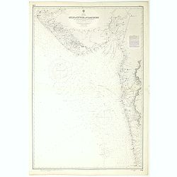
India west coast Gulf of Cutch to Vijaydurg . . .
Chart of India's west coast map surveyed by the hydrographer Captain JF Parry. A highly corrected version of Admiralty chart 2736 originally published 1st July 1915. Date...
- $200 / ≈ €174
Date: London, 1915-1980
Black sea - Sheet IX - Bosporus to Kerempe Burnu . . .
A highly corrected version of Admiralty chart 2238 originally published 16th June 1854. Edition Date 1980.Detailed chart of Bosporus. With prohibited landing places in pu...
- $100 / ≈ €87
Date: London, 1854-1980

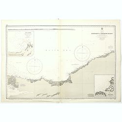
Anamu Buru to Latakia including Iskenderun Körfezi.
A highly corrected version of Admiralty chart 2632 originally published 25 November 1955 under the Superintendence of Captain K.SB. Collins. Edition Date 1984 Detailed ch...
- $100 / ≈ €87
Date: London, 1955 - 1984
China sea Gulf of Tongking (Southern sheet).
A highly corrected version of Admiralty chart 3989 originally published 11 Mai 1962 under the Superintendence of Captain EG Irving. Detailed chart including the coasts of...
- $80 / ≈ €69
Date: London, 1962 - 1992
West Indies Virgin islands Sheet III Tortola I. to Culebra including St. Thomas...
An British Admiralty chart of the Virgin Islands. A highly corrected version of Admiralty chart 2452 originally published 15th December 1856 under the Superintendence of ...
- $135 / ≈ €117
Date: London, 1856- 1988-1993
China Sea Philippine Islands - San Bernandino Strait and approaches. (3370)
A highly corrected version of Admiralty chart 3370 originally published 14th November 1924 under the Superintendence of Captain H.P. Douglas. Edition Date 1982 with furth...
- $150 / ≈ €130
Date: London, 1924 / 1996

Philippine Islands - Semirara, Ilin and Ambulong 1.s with part of Mindoro. (971)
A highly corrected version of Admiralty chart 971 originally published 15th February 1866 under the Superintendence of Captain G.H. Richards. Edition Date 1991 with furth...
- $150 / ≈ €130
Date: London, 1866 / 1999
West Indies Anguilla to Puerto Rico showing the approaches to the Virgin Islands . . .
A highly corrected version of Admiralty chart 130 originally published 22nd June 1868 under the Superintendence of Captain G.H. Richards. Edition Date 1974 with further c...
- $100 / ≈ €87
Date: London, 1868 - 1999

Philippine Islands - Mindanao West Coast - Basilan Strait to Camiguin Island including Tubbataha Reefs. . . (3811)
A highly corrected version of this oversized Admiralty chart 3811 originally published 26th February 1925 under the Superintendence of Captain P.H. Douglas. Edition Date ...
- $150 / ≈ €130
Date: London, 1925 / 2005