Search Listings matching "herrera"
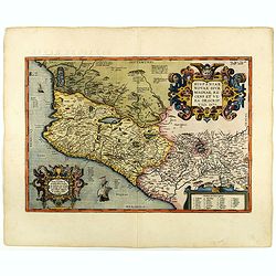
Hispaniae novae sive magnae recens et vera descriptio. 1579
This was the standard map of the area for a generation, copied by De Bry, Quad and Hondius. Even though Herrera (Spain's Royal Cosmographer) and Wytfliet worked 20 years ...
Date: Antwerp, 1598
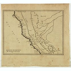
Descripcion Del Destrieto Del Audiencia De Lima. (Peru, and parts of Colombia, and Brazil)
Rare early map of the Audiencia of Lima, locating rivers and settlements, the earliest map to include information from the previously secret manuscript maps of the Spanis...
- $475 / ≈ €404
Date: Amsterdam, Michel Colin, 1622
![[The attack by Schouten and his men on a waka.]](/uploads/cache/39658-250x250.jpg)
[The attack by Schouten and his men on a waka.]
Scarce print on French text sheet showing the attack by Schouten and his men on a waka.From a description of the voyage of Le Maire and Schouten included in the first Fre...
- $200 / ≈ €170
Date: Amsterdam, 1622
![[Locals.]](/uploads/cache/39659-250x250.jpg)
[Locals.]
Scarce print on French text sheet showing a copper engraved view of locals in Oceania.From a description of the voyage of Le Maire and Schouten included in first French t...
- $150 / ≈ €128
Date: Amsterdam, 1622
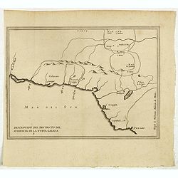
Descripcion del destricto del audiencia de la Nueva Galicia. 5.
The earliest map to include information from the previously secret manuscript maps of the Spanish cosmographer, Juan López de Velasco, showing part of Central America, i...
- $300 / ≈ €255
Date: Amsterdam, Michel Colin, 1622
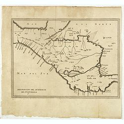
Descripcion del audiencia de Guatimala 6
The earliest map to include information from the previously secret manuscript maps of the Spanish cosmographer, Juan López de Velasco, showing part of Central America, i...
- $400 / ≈ €340
Date: Amsterdam, Michel Colin, 1622
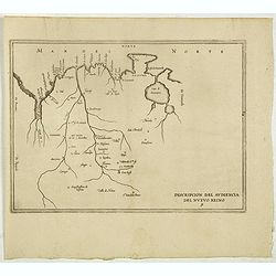
Descripcion del audiencia del Nuevo Reino 9.
The earliest map to include information from the previously secret manuscript maps of the Spanish cosmographer, Juan López de Velasco, showing present-day Colombia and V...
- $450 / ≈ €383
Date: Amsterdam, Michel Colin, 1622
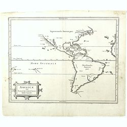
Americae sive Indiae Occidentalis.
Hessel Gerritsz., the author and probable engraver of the map had seen maps of California as an island, but he relies on the more trustworthy accounts, such as Herrera, i...
- $1000 / ≈ €850
Date: Leiden, 1625
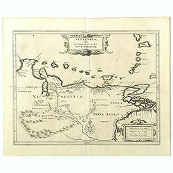
Venezuela, atque Occidentalis Pars Novæ Andalusiae.
The coastline of Venezuela with little interior development. Including Aruba, Bonaire, Curaçao, etc. This scarce map was prepared by Hessel Gerritsz (1581-1632), a forme...
- $600 / ≈ €510
Date: Leiden, 1625
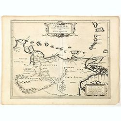
Venezuela, atque Occidentalis Pars Novæ Andalusiae.
Coastline of Venezuela with little interior development. Including Aruba, Bonaire, Curaçao, etc. Scarce map prepared by Hessel Gerritsz (1581-1632), former apprentice of...
- $600 / ≈ €510
Date: Leiden, Elzevier, 1630
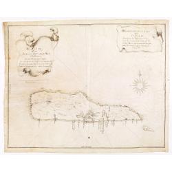
Descripcion de la Isla de Curaçao; Sacada de los Papeles que vinieron a el R.L Consejo de las Indias d. Fran.co Núñez Melián Gouvernador de Venezuela fechos en Caracas en 4° de Diciembre, de 1634 Anos
JUAN DE HERRERA Y ADUILAR - Descripcion de la Isla de Curaçao; Sacada de los Papeles que vinieron a el R.L Consejo de las Indias d. Fran.co Núñez Melián Gouvernador...
Date: Sevillia, c.1635-1652

Tabula Americae Specialis Geographica Regni Peru, Brasiliae, Terra Firmae & Reg: Amazonum, Secundum relationes de Herrera, de Laet & PP d Acuña & M. Rodriguez . . .
A good and clean copy of Homann's map of the northern part of South America. The map is on the Valley of the Amazon and delineates the Amazon and its labyrinth of tributa...
Date: Nuremberg, 1728

