Search Listings matching "geological"
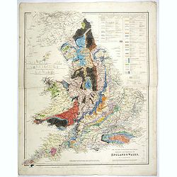
The Inland Navigation, Rail Roads, Geology and Minerals of England & Wales.
A beautifully color-coded and robustly labelled map describes the geology of England and Wales. The colors indicate particular rock materials in accordance with a key at ...
Date: London, 1834
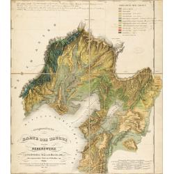
Geognostische Karte des Taurus und seiner Nebenzweige in den Paschaliken Adana und Marasch…
Complete title : "Geognostische Karte des Taurus und seiner Nebenzweige in den Paschaliken Adana und Marasch, nebst dem angrenzenden Theile des Paschalikes von Alepp...
Date: Militärisch - geographischen Institute zu Wien, 1842
Geological Survey of Victoria.
The portfolio with the gold stamped title "Geological Survey of Victoria", contains 51 sheets maps. There is a pocket attached to the inside front cover contain...
Date: Mining and Geological Department, Melbourne, ca. 1864

Kiepert's Physikalische Wandkarten. VI. Nord-America.
Large folding school wall map of North and Central America printed in chromo-lithography. Published by Dieter Reimer and printed by Leopold Kraatz in Berlin. Three inset...
Date: Berlin, Dieter Reimer, 1864
(Set of 4 maps) Itinéraire de Pékin à Sartchy
Set of 4 geological maps from the "Nouvelle Archives du Museum" printed by Becquet.1) Route de Pekin a Suen-Hoa-Fou2) Route de Thae-Seu-Tchouang aux tentes mong...
Date: Paris, ca. 1880

Dutton Map of the Grand Canyon, Arizona (in 4 joined sheets)
An important 1882 map of the Grand Canyon, Arizona, published in "Atlas To Accompany The Monograph On The Tertiary History Of The Grand Canon District By Capt. Clare...
Date: Julius Bien and Co., 1882
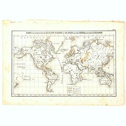
Kaart, voorstellende de Seculaire Rijzingen en Dalingen van den Bodem, alsmede de Vulkamen.
One of the earliest thematic world maps published in the Netherlands from "Atlas der natuurkundige aardrijkskunde. . .". prepared by Nicolaas Wilhelmus Posthumu...
- $35 / ≈ €31
Date: Amsterdam, C.L. Brinkman, 1883
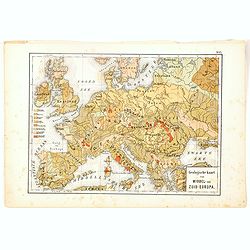
Geologische Kaart van Middel- en Zuid-Europa.
One of the earliest thematic maps published in the Netherlands from "Atlas der natuurkundige aardrijkskunde. . .". prepared by Nicolaas Wilhelmus Posthumus. Wit...
- $35 / ≈ €31
Date: Amsterdam, C.L. Brinkman, 1883

Geological Survey of Japan. Reconnaissance map. Geology. Division 1. 2. 3. 4.
According to Original Surveys and Designs by Dr. Edmund Naumann ; assisted by Takao Fujitani, Akira Yamada, Ichitaro Ban, Shogo Nishiyama ; engraved by S. Takenouchi, K. ...
- $1500 / ≈ €1318
Date: Tokyo, Toyodo Engraving Office, 1886
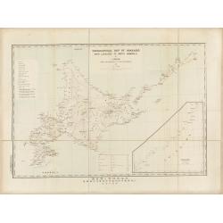
Topographical map of Hokkaido with localities of useful minerals.
Bilingual (English/Japanese) topographic map (1:1,500,000) of Hokkaido Island detailing the distribution of mineral deposits and mining sites (“useful minerals”), publish...
Date: Hokkaidōchō (Gouvernement de Hokkaidō), Sapporo, 1891
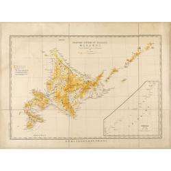
Mountain system of Hokkaido.
Bilingual English/Japanese map of Hokkaido showing elevations, volcanoes and roads for geological observations, with an inset of Chishima (Kuril Islands).
Date: Hokkaidōchō (Gouvernement de Hokkaidō), Sapporo, 1892
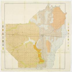
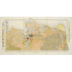
![[Soil map] Virginia-Maryland-West Virginia, Leesburg sheet.](/uploads/cache/23257-250x250.jpg)
[Soil map] Virginia-Maryland-West Virginia, Leesburg sheet.
Early color lithographed soil map by Julius Bien & Co. in New York for Department of Agriculture. Legends at side give detail on soil type, etc. They also include int...
Date: New York, 1903
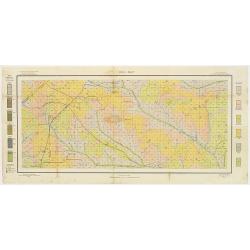
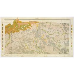
Soil map - Louisiana, Ouachita sheet.
Early color lithographed soil map by Julius Bien & Co. in New York for Department of Agriculture. Legends at side give detail on soil type, etc. They also include int...
- $40 / ≈ €35
Date: New York, 1903
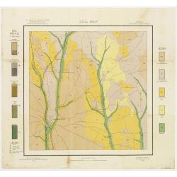
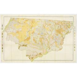
Soil map - Georgia, Fort Valley sheet.
Early color lithographed soil map by Julius Bien & Co. in New York for Department of Agriculture. Legends at side give detail on soil type, etc. They also include in...
- $50 / ≈ €44
Date: New York, 1903
Soil map - Texas, Nacogdoches sheet.
Early color lithographed soil map by Julius Bien & Co. in New York for Department of Agriculture. Legends at side give detail on soil type, etc. They also include int...
- $75 / ≈ €66
Date: New York, 1903
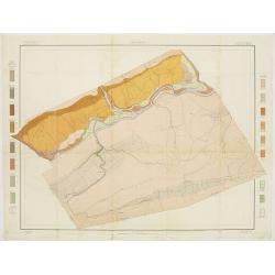
Soil map - Pennsylvania, Lockhaven sheet.
Early color lithographed a href="https://www.swaen.com/map-types/geological-maps">soil map by Julius Bien & Co. in New York for Department of Agriculture...
- $50 / ≈ €44
Date: New York, 1903
Soil map - Virginia Norfolk Sheet.
Soil map printed by Julius Bien & Co. in New York for the Department of Agriculture. The map gives great detail of the area centered on Norfolk, Potsmouth, Chesapeake...
- $50 / ≈ €44
Date: New York 1903
Soil map - South Carolina Campobello Sheet.
Early color lithographed soil map by Julius Bien & Co. in New York for the Department of Agriculture. Legends at the side give detail on soil type, etc. They also inc...
- $50 / ≈ €44
Date: New York, 1903
Soil map - Florida, Gadsden County sheet.
Early color lithographed soil map by Julius Bien & Co. in New York for the Department of Agriculture. Legends at the side give detail on soil type, etc. They also inc...
- $40 / ≈ €35
Date: New York, 1903
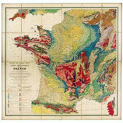
Carte géologique de la France.
Early geological map of France, published by Charles Béranger. Full title: " Ministère des Travaux publics, Carte géologique de la France 1:1'000'000, Exécutée en ut...
- $1200 / ≈ €1055
Date: Paris, 1905
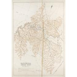
Canberra Contour Survey.
An important large-scale folding map by Charles Scrivener of the present-day city of Canberra, featuring contour lines and elevation data, created as part of the prelimin...
Date: Department of Lands, Sydney N.S.W. July, 1909
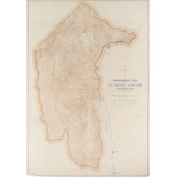
Topographical map of the Federal Territory, Australia.
This map, published by the New South Wales Department of Lands in Sydney in 1910, depicts the Federal Territory—the area designated to house Australia’s future federal ca...
Date: Sydney, Dept. of Lands, 1910
![[Lot of 2 maps] Map of part of New South Wales Australia shewing position of Commonwealth Territory / Map of New South Wales Australia…](/uploads/cache/49457-250x250.jpg)
[Lot of 2 maps] Map of part of New South Wales Australia shewing position of Commonwealth Territory / Map of New South Wales Australia…
Two maps depicting the region of New South Wales and the area designated as the future Commonwealth Territory (which later became the Australian Capital Territory).The fi...
Date: Department of Lands, Sydney NSW, 1911
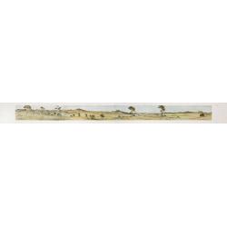
Cycloramic view of Canberra capital site, view looking from Camp Hill / … view looking from Vernon.
Showing an extensive panoramic view of the site of Canberra with various features named. Very large colour photo-mechanical print. Printed by John Sands Ltd [Syd].This 5 ...
Date: Sydney, John Sands, 1911
Geological Map of the Sydney District. / Map of the Sydney District - Geological Structure Contours.
Geological map of the Sydney district. Scale: 2 miles to 1 inch. Prepared under the direction of E.C.Andrews, Department of Mines, NSW.Although geological observations ha...
- $600 / ≈ €527
Date: Alfred James Kent, Government Printer, 1925
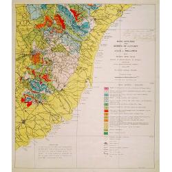
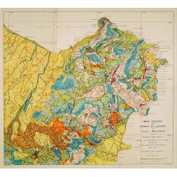
Mapa geologic de les serres de Llevant de l'illa de Mallorca.
Geological map showing part of the island Mallorca Felanitx, Santanyi, Porto Cristo, Porto Colom.., including a legend with geological and topographical signs. After a de...
- $100 / ≈ €88
Date: Palma, 1932
Mapa geologic de les serres de Llevant de l'illa de Mallorca.
Geological map showing part of the island Mallorca Manacor, Son Severa, Capdepera.. After a design by D.Ferrá. Dibuxá, in lower right corner: D.Ferrà. Dibuxá.Provenance :...
- $150 / ≈ €132
Date: Palma, 1932
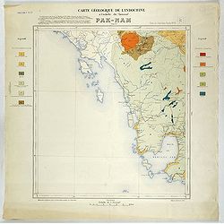
Carte géologique de l'Indochine à l'échelle du 1/500 000e. Pak-Nam Bang-Kok.
Map of Indochina Sheet N ° 16. Covers the area from Paknam (Thailand) to Kompong-Som Bay (Cambodia). On both sides a legend indicates the sedimentary and crystalline land...
- $130 / ≈ €114
Date: Indo Chine, 1939

Carte geologique detaillee. Jbail.
Geological or soil map showing part of Lebanon with Jbail antique Byblos Ancien Port phenicien / scale 1 : 50 000., including a legend with signs of the different geologi...
Date: Liban, Service geographique des F.F.L., 1945

Carte géologique détaillée. Zahle.
Geological map showing part of Lebanon with Zahle. , including a legend with signs of the different geological ages. Provenance : Fondation P. Fallot
Date: Liban, Service geographique des F.F.L., 1945

Carte géologique détaillée. Râchaïya Nord.
Geological or soil map showing part of Lebanon with Râchaïya , including a legend with signs of the different geological ages and giving many informations of greatest int...
Date: Liban, Service geographique des F.F.L., 1945

Carte géologique détaillée. Jezzîne.
Geological or soil map showing part of Lebanon with Jezzîne, including a legend with signs of the different geological ages and giving many information of greatest intere...
Date: Liban, Service geographique des F.F.L., 1945

Carte géologique détaillée. Beyrouth.
Geological or soil map showing part of Lebanon with Beyrouth, including in top a colored legend with signs of the different geological ages. Provenance : Fondation P. Fal...
Date: Liban, Service geographique des F.F.L., 1945
