Search Listings matching "cyprus"
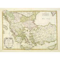
Turquie d'Europe et partie de celle d'Asie…
An attractive map of Turkey, Greece, Cyprus. Prepared by Janvier.
Date: Paris, 1771
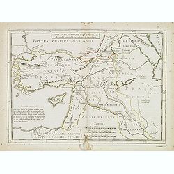
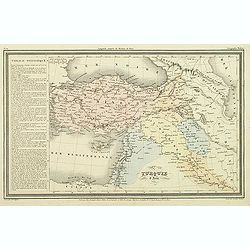
Carte de la retraite des dix mille. . .
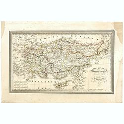
Ancient map of Near and Middle East, including Cyprus, prepared by Nolin and published by L.J. Mondhare for his Atlas Général a l'usage des colleges et maisons d'educat...
- $50 / ≈ €43
Date: Paris, 1781
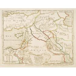
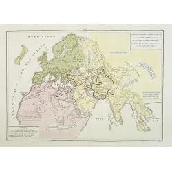
Carte générale pour servir à l'Intelligence de..
Fine map of the Middle East, including the Holy Land, Cyprus, Iran and Irak, etc.Philippe Buache was one of the most active proponents of the so-called, "school of t...
- $300 / ≈ €256
Date: Paris, 1783
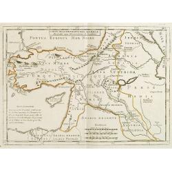
Carte de la Retraite des Dix Mille Accordée aux Observations de l'académie. . .
Ancient map of Near and Middle East prepared by J.B.Nolin and published by Monhare for his Atlas Général a l'usage des colleges et maisons d'education.. Centered on Cyp...
- $100 / ≈ €85
Date: Paris, 1783

Turquie Européenne, Avec les Pays limitrophes. . .
Copper engraved map centered on Greece, extending northwards and eastwards to include the Balkans and Ukraine as well as Cyprus.The map is flanked by two columns of Frenc...
- $50 / ≈ €43
Date: Paris, 1790
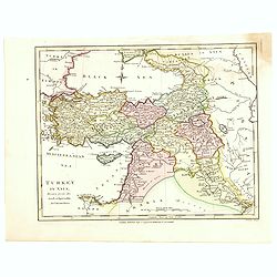
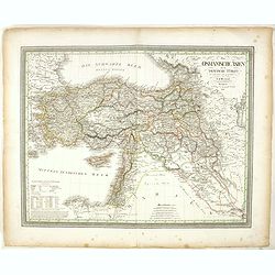
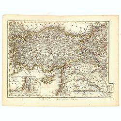
Turkey in Asia.
An attractive map covering Asia Minor, Syria, Armenia, Georgia, Kurdistan, Iraq, Syria, Cyprus and the Black Sea. Shows towns, rivers, mountains, lakes, etc. In pretty or...
- $65 / ≈ €56
Date: London, 1794
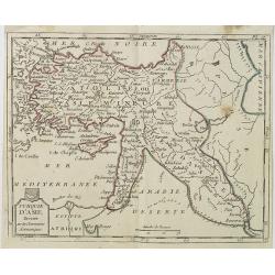
Turquie d'Asie . . .
Map of Turkey, including Cyprus, Palestine, etc. , from Atlas moderne portatif composé de vingt-huit cartes sur toutes les parties du globe terrestre .. A l'usage des Co...
- $100 / ≈ €85
Date: Paris, Prudhomme, Levrault, Debray, 1806
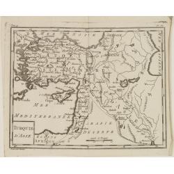
Turquie d'Asie.
Map of Turkey, including Cyprus and part of the Near East. From Atlas de la Géographie de toutes les parties du monde.. Ouvrage destiné pour l'education, et nécessaire...
Date: Paris, Prudhomme, Levrault, Debray, 1806

Karsten Niebuhr.
Stipple engraved portrait of Carsten Niebuhr or Karsten Niebuhr (1733 – 1815), published in F. J. Bertuch "Allgemeine geographische Ephemeriden".Niebuhr was a...
Date: Weimar, 1810
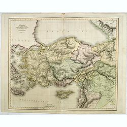
Modern Asia Minor. Drawn & Engraved for Dr. Playfair's Geography.
Detailed map of Black Sea, Cyprus and Turkey engraved by Samuel John Neele (1758-1824) and published by Alexander Macredie. Originally engraved for James Playfair's "...
- $175 / ≈ €150
Date: London / Edinburgh, 1824
Asiae Minoris Stappa generalis ad Caesarum tempus.
A lovely steel engraved map of Turkey, Cyprus and Minor Asia. From Louis de Saint-Martin Vivien's Atlas Universel. Engraved by Giraldon-Bovinet.
Date: Paris, 1826
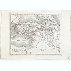
Das Osmanische asien oder die Asiatische Türkey. . .
Decorative map showing 'Asia Minor' with its neighboring countries. Prepared by Karl Ferdinand Weiland The eastern part of the Mediterranean Sea with Cyprus is as well sh...
- $200 / ≈ €171
Date: Weimar, 1836-1838
Il mondo cocsciuto dagli antichi e le laggiori antiche monarchie Persiana, Macedone, Romana . . .
A rare double-page map of the so-called Empire of Alexander the Great (also known as the Macedonian Empire or the Hellenistic Empire ) refers to that great empire , which...
Date: Venice, 1840
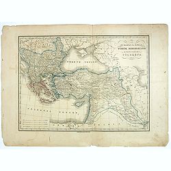
Turquie d'Asie.
Finely engraved map of Turkey, Cyprus, Palestine, Kurdistan and Iraq, prepared by A.H.Dufour and engraved by Giraldon-Bovinet. Published by Jules Renouard in his uncommon...
- $50 / ≈ €43
Date: Paris, Jules Renouard, ca.1840
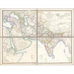
Map of the Countries lying between Turkey & Birmah, Comprising Asia Minor, Persia, India, Egypt & Arabia, and including the Black, Caspian & Red Seas 1841
This striking 4-sheet map, dating to the first half of the 19th century, covers a vast region stretching from Cyprus to Bhutan on the upper sheets and from Egypt to Thai...
Date: London, 1841
Turquie d'Asie.
Detailed map of Asian Turkey with Cyprus, prepared by Charles V. Monin (fl.1830-1880) a French cartographer of Caen and Paris. Published in Atlas Universel de Géographie...
- $45 / ≈ €38
Date: Paris, 1845
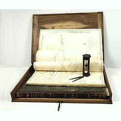
J.Horsburgh/ R.H.Bate / G.H.Stapleton. The two chart books are bound in contemp. half calf, and include together 57 of the most up-to-date French (Depot général de la marine) and English (Hydrographic Office) charts available in 1847 for sailing t
BOOK 1 : Mainly charts by "Dépôt Général de la Marine" including 20 folding charts. The binding measuring 665x275mm, the charts mostly 595x910mm.1. Dépôt ...
- $50000 / ≈ €42724
Date: Paris, London, Hong Kong, 1835 - 1849
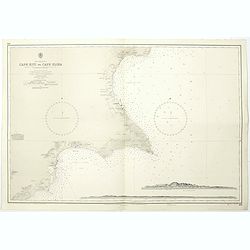
Cyprus south east coast Cape Kiti to Cape Eloea.
An British Admiralty chart of Cyprus south east coast. A highly corrected version of Admiralty chart 971 originally published 15th February 1866 under the Superintendence...
- $100 / ≈ €85
Date: London, 1852
Die Asiatische Turkey 1854.
Steel engraved map, hand colored in outline when it was published. The detailed map shows the Asian part of Turkey, most of Syria, Iraq, Cyprus and the southern reaches o...
- $70 / ≈ €60
Date: Hildburghausen, Bibliograph Institut,1854
Az Europai és Asiai Torok Birodalom Kozonséges Foldképe
Hungarian map of Turkey, including Greece, Cyprus, etc.
- $150 / ≈ €128
Date: Pesten, 1864

I tre diogene. Papagallo No. 43. Anno V.
Satirical lithographed plate published in the supplement to the political newspaper charivaric Papagallo / Le Perroquet N. 43, in the 5th year, published in Bologna. Sati...
Date: Bologne, 1877
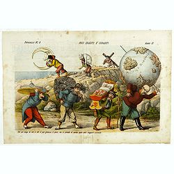
Pesi Graditi ee sgraditi. Papagallo No. 6. Anno VI.
Translation of the legend: "Several weights, each one has to carry its weight, the more serious it is, the longer the trip seems to be, and they will come sooner or ...
Date: Bologne, 1878
![[Map of Turkey in Ottoman script]](/uploads/cache/40765-250x250.jpg)
[Map of Turkey in Ottoman script]
Map of Turkey, including Cyprus, with text in Ottoman script. In the bottom a color key to the different regions. Published by Elbemühl Graphische Industrie in Vienna (f...
Date: Vienna, ca. 1915

Anamu Buru to Latakia including Iskenderun Körfezi.
A highly corrected version of Admiralty chart 2632 originally published 25 November 1955 under the Superintendence of Captain K.SB. Collins. Edition Date 1984 Detailed ch...
- $100 / ≈ €85
Date: London, 1955 - 1984