Search Listings matching "curated-collection"

102 listings found. Showing results 81 to 102
A plat of the East Sea. By William Fisher and Richard Mount...

An important sea chart of the East Sea with coast lines of Poland, Russia, Sweden, published by William Fisher and Richard Mount in London.Richard Mount (1654-1722) was a...

$1800 / ≈ €1684
Maker / Publisher: FISHER, W./ MOUNT, R.
Place & Date: London, 1795


Le Isole di Sandwich delineate sulle osservazioni del Cap Cook.

FIRST EDITION on laid paper. Cassini’s splendid map depicts Sandwich islands, old name for Hawaii islands, at the end of the eighteenth century. The splendid cartouche ...

$7000 / ≈ €6550
Maker / Publisher: CASSINI, G.M.
Place & Date: Rome, 1798


New Yok entworfen von D.F. Sotzmann. Hamburg bey Carl Ernst Bohn 1799 . . . NO.VII

An extremely rare map of New York prepared by Daniel Friedrich Sotzmann for Christopher Ebeling's "Erdbeschreibung von Amerika", a project ended after only ten ...

$6000 / ≈ €5614
Maker / Publisher: SOTZMANN, D.F.
Place & Date: Hamburg, Carl Ernst Bohn, 1799


Erfolgte Kapitulation zwischen dem General Bonaparte und den Gross Leister von Malta. Vor der Hauptstadt Walette zu Maltha, am 10 Juni 1798.

Copper engraving with three scenes and one portrait on one sheet. In upper a view of Bonaparte arriving at Valletta. Published in "Allgemeine Welt-Chronik oder neue ...

$2500 / ≈ €2339
Maker / Publisher: GOTTFRIED BAUMANN CO.
Place & Date: Zittau, 1798-1800


Plan de la ville de Rome, d'après celui publié par J.B. Nolli . . .

Beautiful town-plan of Rome, drawn up after the famous plan of Rome, executed by Giambattista Nolli in 1748. Decorated with a beautiful title cartouche topped by the coat...

$1000 / ≈ €936
Maker / Publisher: LATTRÉ, J.
Place & Date: Paris, Jean, 1801


Carte de la Georgie et du Pays des Ossetes, Tcherkesses et Mitzdcheghi, Par Jules Klaproth (1823).

Detailed manuscript map of Georgia, based upon an 1823 map by Jules Klaproth. The map depicts the rugged terrain of Georgia and southern Russia in impressive detail from ...

$4000 / ≈ €3743
Maker / Publisher: KLAPROTH, Jules.
Place & Date: Paris, ca. 1823


Eastern passage to China. sheet 1.

James Horsburgh early chart of the coasts of Java, Bali, Lombok, with part of Sulawesi, and Borneo. Insets of "Sketch of Bally Strait", Sketch of Lombock Strait...

$2500 / ≈ €2339
Maker / Publisher: HORSBURGH, JAMES, F.R.S
Place & Date: London, 1824


Carte des Iles Hawaii.

A lovely small map of the complete chain of Pacific islands known today as the Hawaiian islands, from Dumont d'Urville's atlas "Voyage pittoresque autour du Monde.&q...

$500 / ≈ €468
Maker / Publisher: DUMONT D'URVILLE, Jules.
Place & Date: Paris, 1834


A-Na-Cam-E-Gish-Ca. A Chippeway Chief.

Half-length portrait of Anacamegishca, bare-chested, wearing a blanket and a peace medal. A-Na-Cam-E-Gish-Ca (1785-1862) - was a Chippeway Indian Chief. The Chippewa is o...

$350 / ≈ €328
Maker / Publisher: MCKENNEY, T and HALL, J.
Place & Date: Philadelphia, 1837


Kaart van de Gaspar Straaten volgens opnemingen van J.Stolze, D.Ross, enz.

Very large and rare chart centered on the strait between Bangka's southeastern seacoast and Belitung's western shores.Short front views of the coastal relief are shown in...

$900 / ≈ €842
Maker / Publisher: HULST VAN KEULEN, Wed.G.
Place & Date: Amsterdam 1843


Straat Riouw onder opzicht van de commissie tot verbetering der Indische Zeekaarten..

Very large and rare so-called Blue Back centered on the strait passing between the Riau Islands. It contains an inset map with enlarged details of Riouw Harbor on Bintang...

$1200 / ≈ €1123
Maker / Publisher: HULST VAN KEULEN, Wed.G.
Place & Date: Amsterdam 1843


ISLA DE CUBA [with 2 maps] Plano Pintoresco De La Habana con los numeros de las casas B. May y Ca. 1853. (with) Inset map Puerto y Cereanias De La Habana. (with) 14 views of Havana & prominent buildings.

Lithographic town-plan surrounded with views of the city of Havana including the "Fuente De La India En El Paseo De Isabel 2a." and "Vista Gral De La Haban...

$3500 / ≈ €3275
Maker / Publisher: MAY, B. Y CA.
Place & Date: Havana, 1853


Le Sacre Hagard [Haggard-falcon]

A beautiful elephant folio sized colored lithograph of a Hagard Falcon, taken from the famous book on Falconry Traite de Fauconnerie by Schlegel and A.H. Verster van Wulv...

$2500 / ≈ €2339
Maker / Publisher: SCHLEGEL, ARNZ, A & COMP
Place & Date: Leiden, 1844-1853


Carte d'unne partie de l'Arabie Septentrionale Pour suivre les Voyages de Mr. G.A. Vallin. . .

This is the original hand-drawn map by Victor Adolphe Malte-Brun of "Carte d'unne partie de l'Arabie Septentrionale Pour suivre les Voyages de Mr. G.A. Wallin",...

$3000 / ≈ €2807
Maker / Publisher: MALTE-BRUN, V.A.
Place & Date: Paris, November 1855


NEWTON'S New and Improved TERRESTRIAL GLOBE Accurately delineated from the observations of the most esteemed NAVIGATORS AND TRAVELLERS to the Present Time. . .

A very impressive Victorian 20-inch Library globe showing the "Gulf of Corea". On an exceptionally carved mahogany tripod stand with scrolling acanthus legs ter...

$25000 / ≈ €23393
Maker / Publisher: NEWTON and SON
Place & Date: London, January 1, 1867


North Pacific.

Huge three sheet so-called Blue-back sailing chart of the Northern Pacific including China, Korea (with Matu Is. and Liancourt), Japan, Philippines, Kamchatka, Hawaii, Al...

$2000 / ≈ €1871
Maker / Publisher: IMRAY AND SON, J.
Place & Date: London, 1868


Mapa geogra´fico de la mayor parte de la Ame´rica Meridional que contiene los paises por donde debe trazarse la li´nia divisoria que divida los dominios de Espan~a y Portugal. . .

Rare first edition of the map drawn by Francisco Requena (1743-1824) after his expedition to the Amazon in order to delineate the boundary between the Spanish and Portugu...

$3000 / ≈ €2807
Maker / Publisher: REQUENA, F.
Place & Date: Bourquin, F. Philadelphia, ca. 1876


Kaart van Het Noordelijk Gedeelte Van Het Eiland Borneo.

A very detailed map of Northern Borneo including Brunei, taken from the "Atlas der Nederlandsche bezittingen in Oost-Indië", which was published by Departement...

$750 / ≈ €702
Maker / Publisher: STEMFOORT, J.W. / SIETHOFF, J.J.
Place & Date: The Hague, 1883-1885


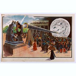
La Lune à un Mètre [Mini poster for Paris Exposition Universelle)

Original lithograph poster for "Paris Exposition Universelle" held between April and November, 1900, which received 50 million visitors. In 1899, director Geor...

$900 / ≈ €842
Maker / Publisher: TRUCHET, A.
Place & Date: Paris, c.1900


COLLECTION OF HONG KONG MAPS, BOOKS & FLYERS. Including CHINA - HONGKONG surveyed by Captn. Sir Edward Belcher, in H.M.S. Sulphur 1841. Corrected to 1901.

A collection of 30 maps, prints, and publications relating to Hong Kong. Including : - BELCHER, E. Sir, An updated version of this most important nautical chart of Hong K...

$25000 / ≈ €23393
Maker / Publisher: BRITISH ADMIRALTY/ AMONG OTHERS
Place & Date: London, 1841 - 1901


20 advertising gouaches for tobacco industry.

A stunning collection of 20 original square and rectangular decorative commercial designs for the Tabaco industries in gouache and watercolor by the artist and graphic de...

$15000 / ≈ €14036
Maker / Publisher: PICHON, R. (Workshop).
Place & Date: Paris, ca. 1930


Canada.

Decorative poster advertising flights to Canada made by Georges Mathieu. The poster is one of a series of 15 composed of posters of Greece, Israel, Germany, Great Britai...

$300 / ≈ €281
Maker / Publisher: MATHIEU, G. / AIR France
Place & Date: Paris, 1967