Search Listings matching "curated-collection"

Quinta Asie Tabvla.
Woodblock map of Persia from Martin Waldseemüller's 1513 edition of Ptolemy, a landmark work that contributed to major advances in both Renaissance geography and map p...
Place & Date: Strasbourg, J. Schott, 1513
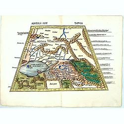
Septima Asie Tabvla.
Trapezoidal woodcut map showing the area around the Caspian Sea from Martin Waldseemüller's most important 1513 edition of Ptolemy, which was a landmark work that contri...
- $6000 / ≈ €5614
Place & Date: Strasburg, J. Schott, 1513
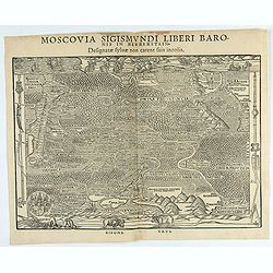
Moscovia Sigismundi Liberi Baronis In Herberstein, Neiperg et Gutehnag Anno M.D XLIX
First Modern Map of Russia. A rare and important cornerstone map for Russia collections.Sigismund von Herberstein made two visits to Russia. In 1517-18 he travelled as a ...
- $3000 / ≈ €2807
Place & Date: Vienna, 1549
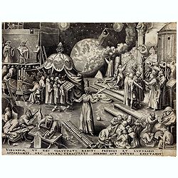
Temperance (Temperantia) from The Virtues.
Very decorative engraving by Philip Galle (Haarlem 1537–1612 Antwerp) after Pieter Bruegel the Elder (Breda (?) ca. 1525–1569 Brussels). The print was published by Hi...
Place & Date: Antwerp, Hieronymus Cock, 1580

Descrittione di M. Lodovico Guicciardini patritio Fiorentino, di tutti i Paesi Bassi,...
Second Italian edition (variant B) and first Plantin edition (1st Silvius 1567) and the most sought-after edition of the famous description of the Low Countries, updated ...
Place & Date: Antwerp, Plantin, 1581

Universe Europae Maritime Eiusque Navigationis Descriptio. Generale Pascaerte van Europa . . .
This general chart of north-western Europe and the surrounding coastal waters is from the rare pilot-guide De Spiegel der Zeevaerdt , printed by Christopher Plantin in Le...
Place & Date: Leyden, 1584
![Imposita saxo Jacob cervice quiescens Aligeros scalas vidit imre choros. Gene[sis] 28](/uploads/cache/47690-250x250.jpg)
Imposita saxo Jacob cervice quiescens Aligeros scalas vidit imre choros. Gene[sis] 28
A superb example of this illustration showing a blind Isaac blessing Jacob. Copper engraving published in " Thesaurus sacrarum historiarum veteris testamenti, elegan...
Place & Date: Antwerp, 1585

Mercurius.
Mercury holding a caduceus and riding in a chariot drawn by two birds on the clouds in the sky, an extensive landscape with a harbor with goods being loaded and unloaded ...
Place & Date: Antwerp, 1585

Itinerarium Sacrae Scripturae. Das ist: Ein Reisebuch...
Itinerarium Sacrae Scripturae. Das ist: Ein Reisebuch, Uber die gantze heilige Schrifft, in zwey Bücher geteilet... Zuvor gemehret mit einem Büchlein De monetis et mens...
Place & Date: Magdenburg, 1587

Lapis polaris magnes.
This is a plate from a series of twenty prints illustrating new inventions and discoveries (Nova Reperta) after Jan van der Straet. On image, bottom right: 'Ion. Stradanu...
Place & Date: Antwerp, Philips Galle, c. 1590
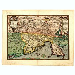
Fori Ivlii accvrata descriptio
Map from 'Theatrum Orbis Terrarum [Atlas of the Whole World]': published in Antwerp. Provenance: This map is from the personal collection of dr. Marcel van den Bro...
Place & Date: Antwerp, 1592

Lutetia Furens. Das ist : Die wütende Statt PARIS.
Rarissime placard dirigé contre la Ligue et le duc de Mayenne. La gravure est signée I.S. (marque inconnue). Ce placard en latin et en allemand est une reprise de l’e...
Place & Date: France ca.. 1594

Peregrinatie Jesu Christu Een ordentliche beschrijvinge des Heijligen landts....
Very rare separately map of the Holy Land engraved by Joannes van Doetecum Jr. Oriented to the east. The shoreline runs from "Antaradus" in Syria to "Rhino...
- $4000 / ≈ €3743
Place & Date: Amsterdam, ca. 1595

Calecuty Regnum
A rare and unusual depiction of the Indian Ocean between Madagascar, Ethiopia, southern Arabia, and south India and Ceylon.The calligraphy is florid and decorative. The e...
- $2000 / ≈ €1871
Place & Date: Cologne, 1596

Gallia.
Extremely rare map of France, Netherlands, Southern England, Switzerland, and Northern Spain. This map was never regularly included in the Theatrum; Denuce mentions the i...
Place & Date: Antwerp, ca 1598

Il vero ritratto di Nettvno al presente oaupato da gl'imperiali.
Rare and early town-plan of Nettuno, in the province of Rome, which is nowadays a touristic harbor.Issued by Joannes Orlandi who acquired many Lafreri plates, which he re...
- $2700 / ≈ €2526
Place & Date: Rome, 1557 / 1602

Germania.
Second state of this rare "carte à figures"- map of Germany, The Netherlands, Poland and central Europe. Bordered on three sides with portraits and views. In t...
Place & Date: Amsterdam, 1607

Pascaarte van een deel der Oost Zee, tusschen Bornholm ende der Memel, vertonende de ware gelegentheijt der Zeecusten van Pruijssen. . .
This very rare chart of the Northern Coast of Poland with Gdansk, appeared in the rare English edition of Willem Blaeu's 'Het Licht der Zeevaert', an atlas of sea charts ...
- $4000 / ≈ €3743
Place & Date: Amsterdam, 1608

Hydrograhica descriptio
This very rare chart is important as the first printed sea chart of the Mediterranean coast of Spain, Gibraltar, also depicting the northern coast of Marocco.Willem Bar...
Place & Date: Amsterdam, W.Blaeu, 1612

AN EXCEPTIONAL AND VERY RARE PAIR OF CELESTIAL AND TERRESTIAL GLOBES.
BLAEU, Willem Janszoon (1571-1638) AN EXCEPTIONAL AND VERY RARE PAIR OF CELESTIAL AND TERRESTRIAL GLOBES, 9inch / 23cm, with an overall height of 38 cm, Amsterdam, dat...
Place & Date: Amsterdam, dated 1602, but published after 1621

Coloniensis Archiepisscopatus.
Extremely rare first edition of this beautiful map of Cologne and Dusseldorff.Jodocus Hondius Jr. planned to produce a new modern atlas less dependent on the Mercator pla...
Place & Date: Amsterdam, 1629

Composite atlas of the Low Countries.
A composite atlas comprising 18 double-page engraved maps by or after Hessel Gerritsz, Theodoor Galle, Jacob van Deventer, Gerard Mercator, Peter Verbiest, Jean Surhon, C...
Place & Date: [Antwerp, c. 1633
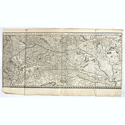
Tractus Danubii, Fluminis in Europa Maximi, A Fontibus, Per Germaniam. . .
This is Blaeu’s first map of the Danube and surrounding regions. The Danube River runs through the map from the top left with its headwaters in the German Black Forest ...
- $2000 / ≈ €1871
Place & Date: Amsterdam, 1634

Amstelodamum, Celebre Emporium Forma Plana.
Second state of this rare and decorative plan of Amsterdam with Visscher's imprint. With a panoramic view seen from the IJ and further insets of Council House, The Exchan...
Place & Date: Amsterdam, c. 1636

Wittstocs.
Very decorative and rare panoramic of Wittstock, Bez. Potsdam.The engraver and publisher of prints, Mrs. Anna Beek of the Hague, enlarged the print and mounted it on larg...
Place & Date: The Hague, ca. 1642

Nouvelle et exacte description du globe terrestre reveue corrigée et augmente´e suivant les derniéres relations des Anglais et Hollandois. Par Guillaume Blaeu 1645.
Extremely rare and decorative "carte a figures" world map published by Anthoine de Fer. The double hemisphere world map is surrounded by constellations of the A...
Place & Date: Paris, 1645

Desciption de lopulente et manifique ville de Venise.
Extremely rare panoramic view of Venice and neighboring islands (Murano, Burano, Torcello and Mazorbo), clearly depicting the city's architectural landmark. The surroundi...
Place & Date: Paris, 1646

Carta prima Generale dell' Asia.
FIRST STATE of Robert Dudley's general chart of the Persian Gulf, going east through India to the southeastern coast of China showing Macau and the area of present-day Ho...
Place & Date: Florence, 1646
![Bressia vulgo Bresse. [colored by Van Santen]](/uploads/cache/29235-250x250.jpg)
Bressia vulgo Bresse. [colored by Van Santen]
Title cartouche with putti and surveyor with surveying instruments. Upper right-hand corner Geneva, lower left Lyon and in the center Bourg-en Bresse. Upper right-hand co...
Place & Date: Amsterdam, 1650
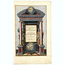
Joannis Janssonii Novus Atlas, sive Theatrum Orbis Terrarum: in quo Orbis Antiquus. . .
A glorious mid-seventeenth century engraved frontispieces to atlas by Janssonius. Finely decorated with a pair of terrestrial (bottom) and celestial (top) globes and the ...
Place & Date: Amsterdam, 1650

Pascaerte vande Caribische Eylanden, vande Barbados tot aende Bocht van Mexico ‘t Amsterdam By Hendrick Doncker. . .
First state. Rare. “This chart appeared in the first edition of Hendrick Doncker’s Zee-Atlas, of which no surviving example is known” -- Burden. This is an example ...
Place & Date: Amsterdam, 1659

Original copperplate.
Showing the coast of southern Morocco, the Sahara with the Canary Islands. Copperplates that had been used in the production of early maps are of the greatest rarity and ...
Place & Date: Amsterdam, ca. 1660
![[Printed on silk] Nova Totius Americae Sive Novi Orbis Tabula, Auct. Hugo Allardt.](/uploads/cache/48420-250x250.jpg)
[Printed on silk] Nova Totius Americae Sive Novi Orbis Tabula, Auct. Hugo Allardt.
Hugo Allard’s ca. 1661 map of the Americas, showing California as an island printed on silk. This separately issued map printed on paper is quite rare on the market. T...
Place & Date: Amsterdam, 1661

Nova XVII Provinciarum Inferioris Germaniae descriptio .
Extremely rare map of the Benelux by Frederick de Widt. Originally engraved and published by P.Kaerius in 1607. In 1662 the plate came in the possession of Frederick de W...
Place & Date: Amsterdam, 1662

Pas-Caart van de Oost Zee verthooende alle de ghelegenheydt tusschen t Eylandt Rugen ende Wyborg. . .
An eye-catching chart of the Baltic Sea. Engraved by Gerard Coeck.Pieter Goos (ca. 1616-1675) was one of the most important cartographers, engravers, publishers and print...
- $1500 / ≈ €1404
Place & Date: Amsterdam, 1666

.Pascaerte Van't Westelyckste der Middelandsche Zee. . .
An eye-catching chart of the western part of the Mediterranean Sea.Pieter Goos (ca. 1616-1675) was one of the most important cartographer, engraver, publisher and print s...
Place & Date: Amsterdam, 1666

Noordoost Cust van Asia van Japan tot Nova Zembla.
Important for its early depiction of Hokkaido and the Islands to the North of Japan. Ships navigate the seas around the Siberian, Chinese and Japanese coast extending as ...
- $3000 / ≈ €2807
Place & Date: Amsterdam, 1666
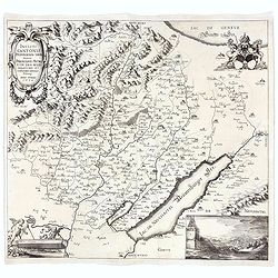
Incliti Cantonis Friburgensis Tabula, autore Francisco Petro VON DER WEID. Senatore et Commissario generale Friburgi. anno Domini 1668.
Very rare 2-sheet map and the first map of the canton Fribourg (Freiburg) in a scale of Scale 1:120.000. South to the top.The area shown on the map encompasses the whole ...
- $7500 / ≈ €7018
Place & Date: Fribourg, 1668

Paskaerte Zynde t'Oosterdeel Van Oost Indien, met alle de Eylanden daer ontrendt geleegen van C. Comorin tota aen Iapan.
An eye-catching chart of Pieter Goos' sea chart of Australia, Southeast Asia, China, Japan, Korea and India. The chart shows the regions from Cape Comorin (Southern India...
Place & Date: Amsterdam, 1669

Paskaerte Vande Bocht van Vranckrijk Biscajen en Galissen
An eye-catching chart of Spain and France, including a large part of Brittany, including Isle de Reé , Isle Saint Martin ...Shows the gulf of the northeast Atlantic Ocea...
Place & Date: Amsterdam, 1669-1676