Search Listings matching "arrowsmith"

United States of North America. Carte des Etats-Unis de l'Amerique Septentrionale / copiée et gravée sur celle d'Arrowsmith, corrigée et considérablement augmentée... par P. F. Tardieu...
FIRST EDITION. An impressive wall map here in 4 unjoined sheets and large margins. RARE in these untouched, full sheets. Recorded examples are usually offered as folding ...
Date: Paris: An XI - 1802

Carte des côtes du Golfe du Mexique compris entre la pointe sud de la presqu'Ile de la Floride et la pointe nord de la presqu'Ile d'Yucatan:...
Detailed and important early chart of the Gulf Coast and Florida and dated 1800. First French edition of "the first printed [map] to show and name Galveston Bay&qu...
Date: Paris, 1800/1803
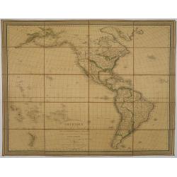
Amérique, réduite d'après celles d'Arrowsmith en 4 flles Par J.N.Champion, Ingénieur-Geographe et . . . Nouvelles découvertes de Clacke et du Major Pike . . .
A charming folding-map of America, drawn by J.N. Champion. The title explains that the map used the latest information by Alexander Humboldt and Clarck and Pike. Dated 18...
- $500 / ≈ €439
Date: Paris, 1815

Map of Pensylvania and New Jersey by H.S. Tanner.
First edition of this rare and important map of Pennsylvania and New Jersey by H.S. Tanner and published in his "New American Atlas" from 1823. Includes roads, ...
Date: Philadelphia, Henry Tanner, 1823
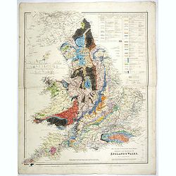
The Inland Navigation, Rail Roads, Geology and Minerals of England & Wales.
A beautifully color-coded and robustly labelled map describes the geology of England and Wales. The colors indicate particular rock materials in accordance with a key at ...
Date: London, 1834
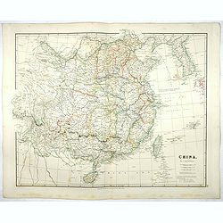
China.
Map of China, Taiwan and Korea. This map by the nephew of Aaron Arrowsmith first appeared in 1832 and was reissued several times. The present issue appeared in Arrowsmith...
Date: London, 1838
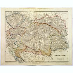
Austrian Empire.
A, large steel engraved map of the mighty Austrian Empire, covering Austria, Dalmatia, Styria, Slavonia, Hungary, Transylvania, Moravia and Bohemia. An enormous amount of...
Date: London, 1839
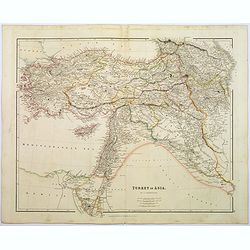
Turkey in Asia.
A lovely looking steel engraved map of Turkey in Asia. Map extent is Asia Minor, Syria, Holy Land, across to the Caucasian peoples that inhabit the lands between the Blac...
Date: London, 1839
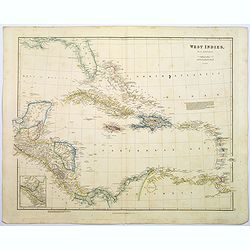
West Indies.
A fine, detailed steel engraved map comprising Florida, Bahamas, Cuba, Haiti, Jamaica, the Windward, and the Leeward Islands, the northern Columbian coastline, Panama, Gu...
Date: London, 1839
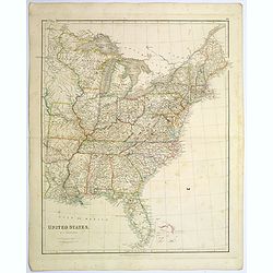
United States.
A lovely large map of the Untied States, as it was at the time of publication. Each state shown in a different outline color. Nothing is shown west of Louisiana, Arkansas...
Date: London, 1839

Upper Canada &c.
A beautiful, large scale map of Upper Canada, and portions of the American states of New York, Ohio, and Pennsylvania. The province of 'Upper' Canada was created by the B...
Date: London, 1839
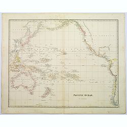
Pacific Ocean.
A wonderfully laid out map of the region, displaying the many island groups that make up this fascinating part of the world. The region is separated into parts, the South...
Date: London, 1839
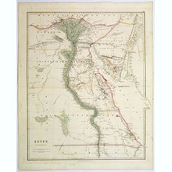
Egypt.
Quite a striking, large steel engraved map of Egypt. Following the course of the River Nile from Lower Egypt southwards to Upper Egypt, then crossing the border with Nubi...
Date: London, 1839
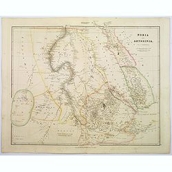
Nubia & Abyssinia.
A lovely looking steel engraved map of the portion of Africa that lies to the west of the Red sea. Mostly great deserts and the territories of nomadic African tribes are ...
Date: London, 1839
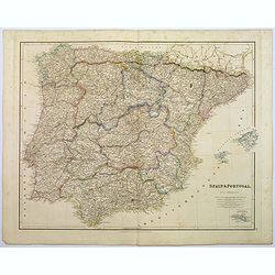
Spain & Portugal.
A large steel engraved map of European neighbours of Spain and Portugal. Including Balearic Islands, with a further inset map of Minorca. Numerous place names and physica...
Date: London, 1839
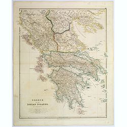
Greece and the Ionian Islands.
A large steel engraved map concentrating on Greece and the Ionian islands. Featured are Albania, Corfu, Macedonia, Central Greece and Morea., along with many small island...
Date: London, 1839
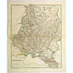
Russia & Poland.
A glorious, large steel engraved map of Russia and Poland. Covering Poland and Finland in the west, as far south as to the very edges of Persia, the Black sea, and to the...
Date: London, 1839
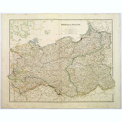
Prussia & Poland.
A glorious, large steel engraved map of Prussia and Poland. Some of the states covered are: Saxony, Pomerania, Posen, Brandenburg, Western & Eastern Prussia and the K...
Date: London, 1839
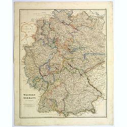
Western Germany.
A lovely, large steel engraved map of Western Germany. Some of the states engraved are: Holstein, Hannover, Mecklenburg, Saxony, Bavaria, Württemberg and Nassau. An extr...
Date: London, 1839
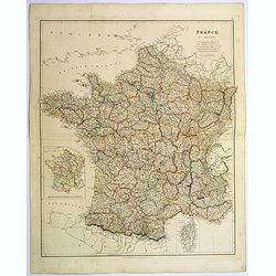
France.
A lovely, large steel engraved map of France, with an inset sketch of France divided into provinces, plus small inset map of the French Mediterranean island of Corsica . ...
Date: London, 1839
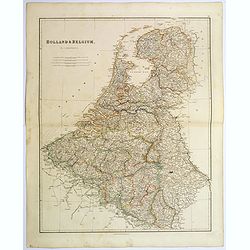
Holland & Belgium.
An attractive steel engraved map of Holland and Belgium. Map flanked by France and Prussia. Duchy of Luxembourg included. Many place names and physical features shown. 4 ...
Date: London, 1839
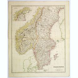
Sweden & Norway.
An attractive steel engraved map of Sweden & Norway. An inset map which is the continuation from Tornea to North Cape. Many place names and physical features shown.Th...
Date: London, 1839
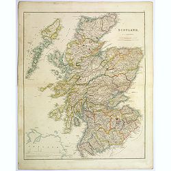
Scotland.
An attractive steel engraved map of Scotland, with each county divided by a different color. Many place names and physical features shown.The Arrowsmith family members we...
Date: London, 1839
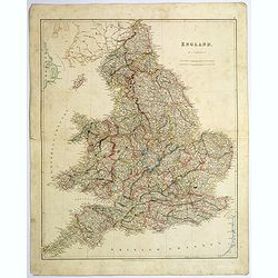
England.
A large and detailed steel-engraved map of England, with each county divided by a different color. Many place names and physical features are shown, illustrating how dens...
Date: London, 1839
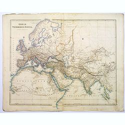
Orbis Veteribus Notus.
This is a detailed steel-engraved map of the ancient world, stretching from Europe eastwards to the Black Sea and beyond, southwards through northern Africa, Arabia, Indi...
Date: London, 1839

Arabia. Sive Regio inter Mare Medium, Arabicum Sinum, . . .
Very detailed map of the Arabian Peninsular, covering the Caspian Sea in the upper right corner and Syria to the Indian Ocean, Somalia and parts of Persia, Syria and Kurd...
Date: London, 1841
The Caspian Sea, Khivah, and the surrounding country compiled from the best sources by John Arrowsmith
This is a very detailed map of the Caspian Sea regions to the north and east. It includes the Caspian Sea, Aral Sea, and the khanate of Khiva, including parts of today's ...
- $450 / ≈ €395
Date: London, 1846-1858
