Search Listings matching "ORTELIUS"
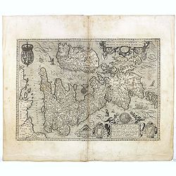
Angliae, Scotiae, et Hiberniae, sive Britannicar : Insularum descriptio.
A rare and ornate map with inset portraits of James First, Henry Prince of Wales Princess Anne of Denmark.Janssonius acquired the copperplate of van den Keere's 1604 Brit...
Date: Amsterdam, 1621
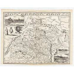
Moravia Marchionatus. Merhern.
First state of this rare map by Pieter van den Keere. The title runs across the top of the map. In the upper left a view of "Brin", in the lower right corner a ...
- $1800 / ≈ €1569
Date: Amsterdam, Pieter van den Keere, [before 1623
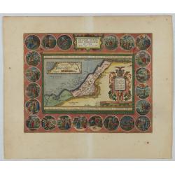
Abrahami Patriarchae Peregrinatio et Vita.
The Holy Land map itself occupies the center and is surrounded by vignettes of the life of the Patriarch Abraham. Extremely decorative map made by Ortelius, based on Ptol...
Date: Antwerp, 1624
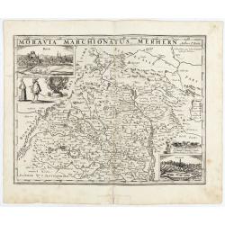
Moravia Marchionatus. Merhern.
Second state of this rare map by Pieter van den Keere, published by Abraham Janssonius with the following imprint added : “Abrahamus Janssonius Excud : 1625".The t...
- $1600 / ≈ €1395
Date: Amsterdam, Abrahamus Janssonius, 1625
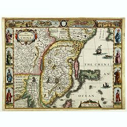
The Kingdome of China.
A most sought-after map of China. Decorative border vignettes including views of the cities of Quinzay and Macao along the top border with the wheeled wind machines and p...
Date: London, G. Humble, 1626

The Kingdome of China.
A most sought-after map of China. Decorative border vignettes including views of the cities of Quinzay and Macao along the top border with the wheeled wind machines and p...
Date: London, G. Humble, 1627

Romani Imperii Imago.
Very rare map in a first edition by Jacques Honervogt. Copied after a map by Ortelius but much rarer. The medallion portraits are of Romulus and Remus - the genealogical ...
Date: Paris, 1630
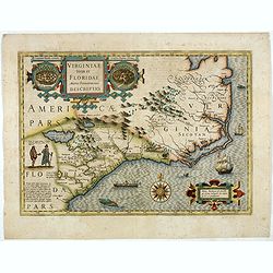
Virginiae item et Floridae. . .
Cummings describes it as one of the most beautifully executed maps ever made of the Southeast. In detail and in general conception it surpasses all earlier maps of the re...
- $2200 / ≈ €1918
Date: Amsterdam, 1630
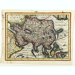
Asia.
Asia map from the rare Cloppenburg edition slightly larger format and more scarce edition of the Mercator/Hondius "Atlas Minor". Engraved by Pieter Van Den Keer...
Date: Amsterdam, 1630
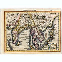
India Orientalis.
Map covering India, Thailand, Philippines, Northern Borneo and the coast of Southern China. From the rare Cloppenburg edition "Atlas Sive Cosmographicae Meditationes...
- $550 / ≈ €479
Date: Amsterdam, 1630
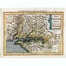
Virginiae item et Floridae . . .
Map of Virginia from the rare Cloppenburg edition slightly larger format and more scarce edition of the Mercator/Hondius "Atlas Minor". Engraved by Pieter Van D...
- $750 / ≈ €654
Date: Amsterdam, 1630
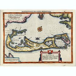
Description des Isles Bermudas.
Map of Bermuda from the rare Cloppenburg edition slightly larger format and more scarce edition of the Mercator/Hondius "Atlas Minor". Engraved by Pieter Van De...
- $800 / ≈ €697
Date: Amsterdam, 1630
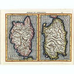
Corsse et Sardaigne.
Maps of Corsica and Sardinia from the rare Cloppenburg edition slightly larger format and more scarce edition of the Mercator/Hondius "Atlas Minor". Engraved by...
- $300 / ≈ €262
Date: Amsterdam, 1630
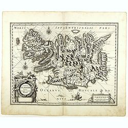
Tabula Islandiae. . .
With a very decorative cartouche, and a very fine imprint. No text on verso; included in the rare "Appendix" of 1630. VERY RARE. This handsome map of Iceland wa...
- $1200 / ≈ €1046
Date: Amsterdam, 1630

Composite atlas of the Low Countries.
A unique, made-to-order atlas comprising 18 double-page engraved maps by or after Hessel Gerritsz, Theodoor Galle, Jacob van Deventer, Gerard Mercator, Peter Verbiest, Je...
Date: [Antwerp, c. 1633
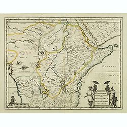
Aethiopia Superior vel Interior vulgo Abissinorum.
An attractive map of Eastern Africa and the fictitious kingdom of Prester John. The map shows a major section of central and eastern Africa including Mozambique north to ...
- $450 / ≈ €392
Date: Amsterdam, 1638

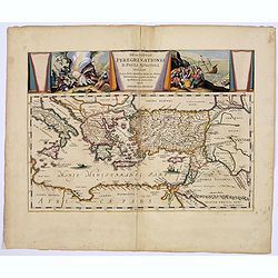
Peregrinations divi Pauli Tyrus Corographicus. . .
A beautifully executed and very rare map showing the peregrinations of St. Paul in the Eastern Mediterranean. The Mediterranean is ornated with two ships and two sea mons...
Date: Paris, ca. 1640

China Veteribus Sinarum Regio.
Based on Jesuit surveys, the map represents the next major revision in the cartography of China after Ortelius' 1584 map. Korea, however, is still an island, and Japan co...
Date: Amsterdam, 1640
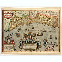
Serenissimae Reipublicae Genuensis Ducatus et Dominii.
Includes the coast of the Riviera from Nice to La Spezia. A most decorative and rare map because it was only included in the Vrients' editions of the Ortelius Theatrum . ...
Date: Antwerp, 1609-1641
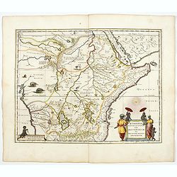
Aethiopia Superior vel Interior vulgo Abissinorum.
An attractive map of Eastern Africa and the fictitious kingdom of Prester John. The map shows a significant section of central and eastern Africa, including Mozambique, n...
- $700 / ≈ €610
Date: Amsterdam, 1644

Americae Nova Tabula.
An inset shows Greenland and Iceland. Decorative elements include ships, sea monsters, and vignettes of native Americans within South America. In addition, the map is bor...
- $6500 / ≈ €5666
Date: Amsterdam, 1644

Typus Galliae Veteris, Ex conatib' Geograph. Abrah.Ortelii.
A very decorative map with countries of ancient France prepared by Abraham Ortelius and published by one of the most famous map publishers, Willem Blaeu.
Date: Amsterdam, 1645

Americae Nova Tabula.
The delineation of the coast and the nomenclature on both the Pacific and Atlantic coasts are basically Spanish in origin and follow the maps of Ortelius and Wytfliet. To...
Date: Amsterdam, 1645
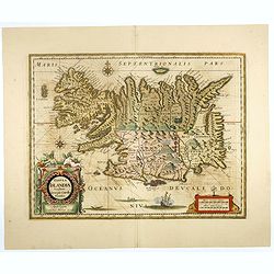
Tabula Islandiae..
This handsome map of Iceland was based on information from a Dutch navigator named Joris Carolus in about 1620. The map shows the influence of both versions of bishop Gud...
- $1100 / ≈ €959
Date: Amsterdam, 1645
Descriptio Peregrinationis D. Pauli, Apostoli. . .
A striking map of the Mediterranean Sea and its surrounding areas. It depicts the travels of the Apostle St. Paul.The pair of decorative cartouches, presented in a curtai...
Date: Amsterdam, 1650
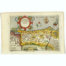
Pomeraniae Wandalice Regionis Tipus.
Miniature map of Pomerania embellished by rich cartouche, vessel and sea monsters in the Baltic. Abraham Ortelius (1527-1598) was a cartographer and publisher, who is bor...
- $250 / ≈ €218
Date: Antwerp, 1667

French composite atlas made up of rare maps published by Parisian editors from the 17th century , mainly by G. Jollain including scarce maps of America.
A rare French composite atlas including 90 maps, published by Parisian publishers from the 17th century, mainly by Gérard I Jollain, or by maps bought from Dutch publish...
Date: Paris, ca. 1675

La Floride. . .
The map is derived from La Floride , 1657, by Nicolas Sanson. Several new rivers appear in Virginia. The Caroline listed is Ft. Caroline, not the Carolinas. The Florida n...
Date: Paris, 1683

A unique composite atlas with updated Porro maps.
Unique composite atlas containing in total 84 maps - 82 maps engraved by Girolamo Porro and heavenly reworked around 1686 and 2 newly engraved maps; Piccola Tartaria (Cr...
Date: Venice, 1686