Browse Listings in Europe > Scandinavia > Denmark

Zee caerte vande Sondt tvermaerste van Danemarcke . . .
A detailed chart of the coast of Denmark and its islands, Copenhagen in the center of the chart. West to the top. It is decorated by a title, scale and descriptive cartou...
Date: Leiden, Plantijn, 1585
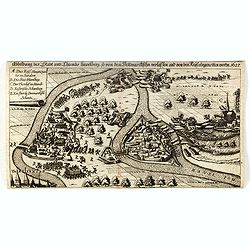
Abbildung der Stadt und Thumbs Havelberg, so von den Dennmarckischen verlassen und von den Keijs: eingenommen worden 1627”. Mindre fågelvy utan horisont med stridande trupper. . .
A separately published plan of the Danish town of Havelberg, with its siege of 1627. The copper engraved plan was also included in the work "Relationis Historicae S...
- $200 / ≈ €172
Date: Frankfurt am Main, ca. 1620
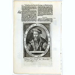
Christianus III. D. G. Daniae Et Norwegiae Rex. Dux Hols. etc.
The engraving depicts a half length oval portrait of "Christianus III".Nicolaes de Clerck (de Klerc) was active as engraver and publisher in Delft from 1599-162...
- $20 / ≈ €17
Date: Amsterdam, Cloppenburch, 1621
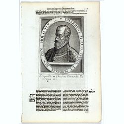
Fredericus II. D. G. Daniae Et Norvegiae Rex. Dux Holsatiae etc.
The engraving depicts a half length oval portrait of "Fredericus II".Nicolaes de Clerck (de Klerc) was active as engraver and publisher in Delft from 1599-1621....
- $20 / ≈ €17
Date: Amsterdam, Cloppenburch, 1621
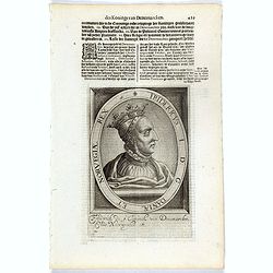
Fridericus I. D. G. Daniae Et Norvegiae Rex. etc.
The engraving depicts a half length oval portrait of "Fridericus I".Nicolaes de Clerck (de Klerc) was active as engraver and publisher in Delft from 1599-1621.I...
- $20 / ≈ €17
Date: Amsterdam, Cloppenburch, 1621

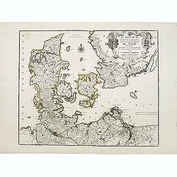
Daniae Regni Typum..
A first state. Very decorative "carte à figures"- map of Denmark with the signature of the engraver Abraham Goos. Printed on heavy paper, in spite of its repai...
Date: Amsterdam, 1629
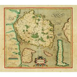
Fionia.
Early map, including Odense and the island Langeland .
- $200 / ≈ €172
Date: Amsterdam 1630

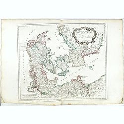
Daniae regni typum . . .
Second Edition, now for the first time with a date (1630), this rare map which - like that of Janssonius-Kaerius - is based on John Speed's map of 1626. The side borders ...
Date: Amsterdam, 1630
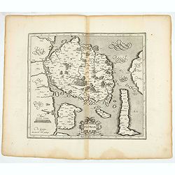
Fionia.
Early map, including Odense and the island Langeland .
- $200 / ≈ €172
Date: Amsterdam, 1630
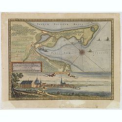
Neoburgum Fioniae oppidum. . .
Decorative plan and panoramic view of the town of Nyborg in Denmark at the coast of Baltic Sea in Fyn. Prepared by Count Erik Jönsson Dahlberg[h] (1625-1703). Military e...
Date: Stockholm, 1697
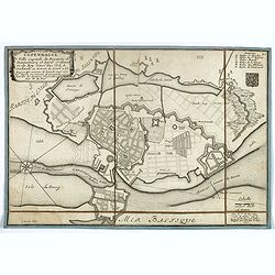
Copenhague ville capitale du royaume de Dannemarq et séjour ordinaire du Roy . . .
Separately published town-plan of Copenhagen, also published in de Fer's "Curious Atlas". Engraved by C.Inselin. Plan is dated 1700 in lower right corner. With ...
- $150 / ≈ €129
Date: Paris, 1700
Le Royaume de Danemarc et les Etats.
Map centered on Sweden and North Germany.
Date: Paris, 1724
Royaume de Danemarck. qui comprend le Nort-Jutland . . . Sélande, Laland.
Finely and crisply engraved map of Denmark. Venetian edition of Giles Didier Robert De Vaugondy's map from Atlas Universel printed in 1776-84. Ornamental title cartouche ...
- $100 / ≈ €86
Date: Venice, 1776 - 1784
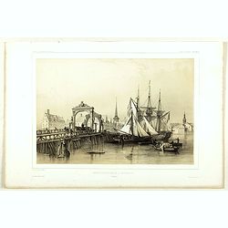
Pont de Knippelsbroe a Copenhague.
View of Knippelsbroe's bridge in Copenhagen. From "Voyage en Scandinavie, en Laponie, etc" - Atlas Pirtoresque (complément). Designed by A.Mayer.
Date: Paris, ca 1834-1838
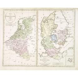
Karta öfver Nederland. / Karta öfver Danmark.
An very rare map of The Low Countries and Denmark with Swedish text. This is an updated version of his map of 1820 and is now dated 1832.From his atlas "Geographisk ...
- $110 / ≈ €95
Date: A. Wiborgs förlag, Stockholm, ca. 1848
