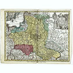
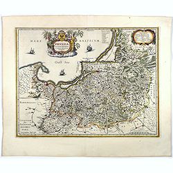
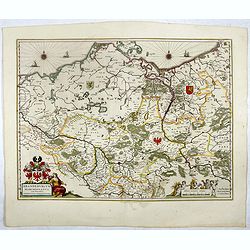
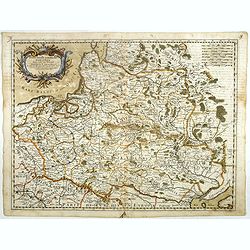
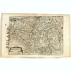
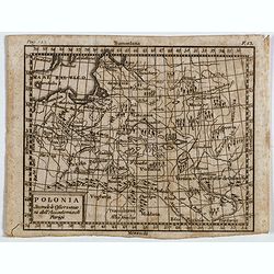
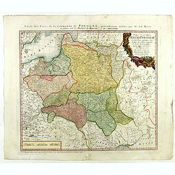
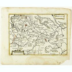
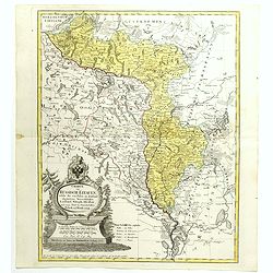
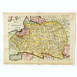
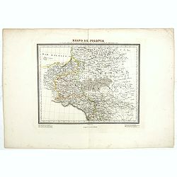
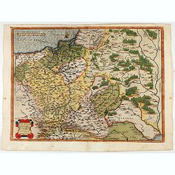
Polonia regnum ut et magni Ducat Lithuania. . .
Miniature map of Poland, a reduction of the appropriate part of Seutter's folio map. Engraved by Tobias Conrad Lotter.From Atlas Minor, here published by Johann Martin Wi...
- $450 / ≈ €421
Place & Date: Augsburg, J.M.Will, 1778

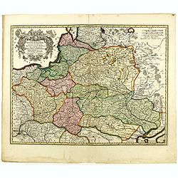
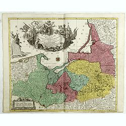
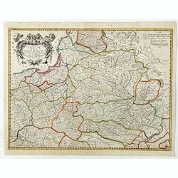
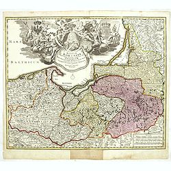
Le Cours de l'Elbe et de l'Oder où sont les Electorats de Saxe et de Brandebourg, les Duchés de Mekelbourg et de Pomeranie. . .
A detailed and scarce map showing the rivers Elbe and Oder in Germany and Poland. Dark engraving.This is one sheet of the four sheet wall map by Pierre Du Val entitled: &...
Place & Date: Paris, 1684
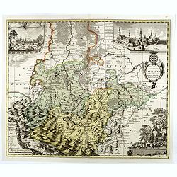
Ducatus Silesiae Iauranus. Aut : Frid : Kühnovio. . .
Rare Pieter Schenk edition of Friedrich Kubn's (Kühnovio) map of Jawor in southwest Poland based on Johann Gottfried Bartsch, map first published in Świdnica (then Schw...
Place & Date: Amsterdam, 1700-1725
Selling price: $1250
Sold in 2017
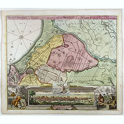
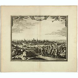
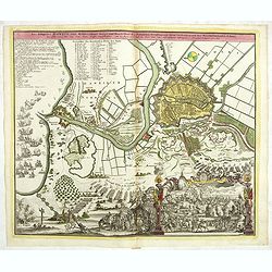
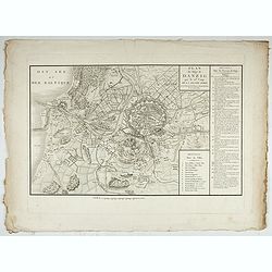
Prospect, Grundriss und Gegend der Polnischen vesten Reichs und Handels-Stadt Dantzig und ihrem Werder. . .
Striking example of Homann's map of Danzig (Gdansk) and neighboring regions and striking birds eye view, major port to the Baltic Ocean, which for centuries was an import...
- $550 / ≈ €515
Place & Date: Nuremberg, ca. 1720
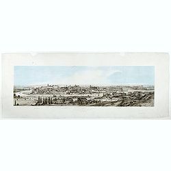
Widok Krakowa od Podgonza.
Bird's-eye view of Krakow city, with underneath the names of thirteen important buildings. Lithographed by J.Brydak after a photo by W. Rzewuskriego. Published by Czasu W...
- $750 / ≈ €702
Place & Date: Krakow, ca. 1865
![Bataille de Pultusk, le 26 Decembre 1806. [manuscript map]](/uploads/cache/38810-250x250.jpg)
Bataille de Pultusk, le 26 Decembre 1806. [manuscript map]
Manuscript map of the siege of Pultusk (located on the west bank of the River Narew approximately 50 kilometres (31 mi) north of Warsaw), on 26 December 1806. With a colo...
- $1750 / ≈ €1638
Place & Date: Breda, 1849
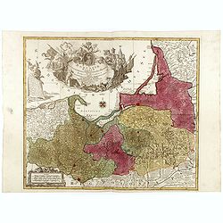
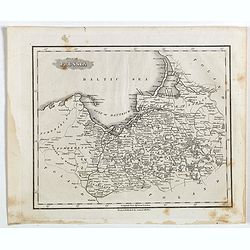
Prussia accurate descriptia a Gasparo Henneberg Erlichensi.
Prussia and the Baltic Region, with two large decorative cartouches, coat of arms, and three sailing ships. As indicated in the title cartouche, the map was prepared by t...
Place & Date: Amsterdam, 1644
Selling price: $500
Sold in 2017
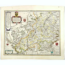
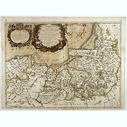
Silesia Inferior. . .
Decorative map prepared by Jonas Scultetus, a Silesian cartographer (1603-1664). More about Willem Blaeu. [+]
- $300 / ≈ €281
Place & Date: Amsterdam, 1644
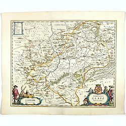
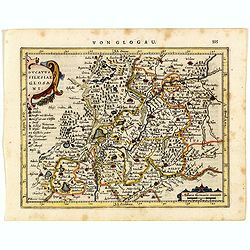
Ducatus Silesiae Glogani Vera Delineatio . . .
Map of Silesia showing the area of Glogow. French text on back. More about Willem Blaeu. [+]
- $350 / ≈ €328
Place & Date: Amsterdam, 1644
Comitatus Glatz.
Nice map by Willem Blaeu of the Silesia region with Glatz (Klodzko) at center. The forested region was renowned for its wild game and the map includes tiny illustrations ...
- $450 / ≈ €421
Place & Date: Amsterdam, 1644
Brandeburgum Marchionatus. . .
Decorative map by Willem Blaeu centered on Berlin and Brandenburg, and part of Poland and Pomerania, Mecklenburg and Rugia with excellent detail of forests, rivers, towns...
- $250 / ≈ €234
Place & Date: Amsterdam, 1644
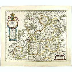
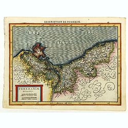
Pomeraniae Wandalice Regionis Tipus.
Miniature map of Pomerania embellished by rich cartouche, vessel and sea monsters in the Baltic. Abraham Ortelius (1527-1598) was a cartographer and publisher, who is bor...
- $250 / ≈ €234
Place & Date: Antwerp, 1667
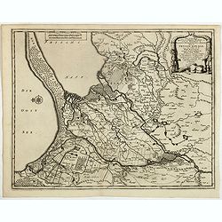
Les trois Iles, appellées en Allemand Werders, ou sont les Territoires de Dantzic, Marienbourg et Elbing dans la Prusse Royale avec les Côtes de la Mer Baltique, suivant la description de Olaus Jean Gotho...
Decorative regional map including the town of Danzig and the region south of it. East to the top. This well-executed engraving was published in 1729 and 1727 by Pieter va...
- $450 / ≈ €421
Place & Date: Leiden, 1719
Elbing. (Elblag in Northern Poland)
Decorative view of the town of Elblag in Northern Poland. This well executed engraving was published in 1729 and 1727 by Pieter van der AA, in Leiden in "Les Voyages...
- $400 / ≈ €374
Place & Date: Leiden, 1719
La ville de Dantzic dans la Prusse Royale.
Decorative view of Danzig. This well executed engraving was published in 1719 by Pieter van der AA, in Leiden in "Les Voyages tres-curieux et tres-renommez faits en ...
- $400 / ≈ €374
Place & Date: Leiden, 1719
Pomeraniae Ducatus.
Pomerania map from the rare Cloppenburg edition slightly larger format and more scarce edition of the Mercator/Hondius "Atlas Minor". Small and detailed map of ...
Place & Date: Amsterdam, 1630
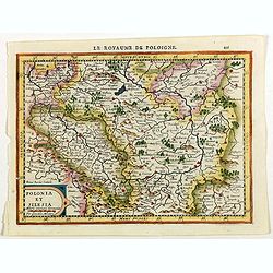
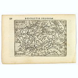
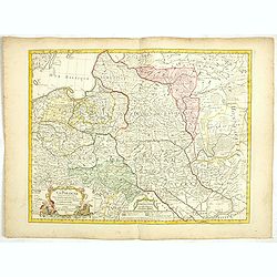
Polonia et Silesia.
Map of Poland and Silesia from the rare Cloppenburg edition slightly larger format and more scarce edition of the Mercator/Hondius "Atlas Minor". Engraved by Pi...
Place & Date: Amsterdam, 1630

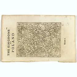
A Newe mape of Poland Done into English by I.Speede.
A wonderful map of Poland. Incorporated into Speed's 'Prospect Of The Most Famous Parts Of The World.' Includes birds-eye views of Cracow, Dantzick, Posna, Crossen, Sando...
Place & Date: London, 1627
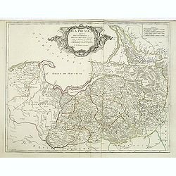
La Prussia Divisa in Reale Che Appartiene al Ré Di Polonia et in Ducale Che Spetta all'Elettore Di Brandeburgo. Da Giacomo Cantelli Da ...
In the upper left-hand corner a large title cartouche with a dedication to Cardinal Denhoff. The map is dated 1689.The cartographer was Giacomo Cantelli (1643-1695) who w...
- $1000 / ≈ €936
Place & Date: Rome, 1689
Stati della Corona di Polonia Divisa nella sue Principali Provincie e Palatinati da Guglielmo Sansone. . .
Rare map of Poland, Lithuania and the Ukraine. Copies of his first edition of 'Mercurio Geografico', published in 1674, do not contain a map of Poland. Only added in late...
- $1250 / ≈ €1170
Place & Date: Rome, 1678
Karte von Polen.
An attractive map of Poland. With a decorative title cartouche in the upper left-hand corner. Engraved by Ant. Amon. Franz Johann Josef von Reilly (Vienna 18 august 1766 ...
- $950 / ≈ €889
Place & Date: Vienna, 1796
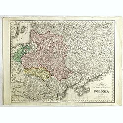
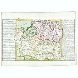
Royaume de Pologne.
Detailed map encompassing present-day Poland. The table provides a breakdown of the sub-regions of the Polish Crown.Venetian edition of the map by R. de Vaugondy, to whom...
- $350 / ≈ €328
Place & Date: Venice, 1776 - 1784
![[manuscript plan] Siège de Schweidnitz en Silésie fait par les trouppes Imperial es commandées par Mr. le de Nadasti ...](/uploads/cache/39893-250x250.jpg)
[manuscript plan] Siège de Schweidnitz en Silésie fait par les trouppes Imperial es commandées par Mr. le de Nadasti ...
This fine manuscript shows the layout of the city of Swidnica with its surrounding defence wall, its advanced bastions and suburbs, roads and two nearby villages. In lowe...
- $2750 / ≈ €2573
Place & Date: France, 1769
A Newe mape of Poland Done into English by I.Speede.
A wonderful map of Poland. Incorporated into Speed's 'Prospect Of The Most Famous Parts Of The World'. Includes birds-eye views of Cracow, Dantzick, Posna, Crossen, Sando...
- $3500 / ≈ €3275
Place & Date: London, 1627

Mapa Polski i Krajów Osciennych - Wydanie trzecie. Opracowal Stanislaw Max. Wydani M. Arcta.
‘The Birth of Modern Poland on a map’ - an excellent wall map of Poland and surrounding regions, published in Warsaw near the end of World War I, when Poland’s fate...
- $1000 / ≈ €936
Place & Date: Warsaw, [H. Sklodowski], 1918
Polonia. (With text page)
Early map of Poland (168x250mm.) printed on a text page, together with another giving a description of the region in English.
- $150 / ≈ €140
Place & Date: Amsterdam, 1612
Polonia et Silesia. (With text page)
Early map of Poland. With English title above the map and an description of the region in English on verso.
- $250 / ≈ €234
Place & Date: Amsterdam, 1612
Carte du pays compris entre Vistule et la Pregel.
Map of Poland regions, including Warsaw, part of Russia and Danzig bay, prepared by Auguste Henri Dufour (1798-1865). Engraved by Ch. Dyonnet.
- $75 / ≈ €70
Place & Date: Paris, 1830
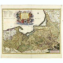
Borussiae Regnum compectens Circulos Sambiensem, Natangiensem, et Hockerlandiae Nee non Borussia Polonica, exhibens Palatinatus Culmiensem. . .
Decorative map covering northern Poland with Prussia, Pomerania, Hockerlandia, Warmiaermelandia, Natanglensis, Galindia, Nandrovia, Sclavonia, and the Baltic Sea. Include...
- $400 / ≈ €374
Place & Date: Augsburg, ca. 1760

Pascaarte van een deel der Oost Zee, tusschen Bornholm ende der Memel, vertonende de ware gelegentheijt der Zeecusten van Pruijssen. . .
This very rare chart of the Northern Coast of Poland with Gdansk, appeared in the rare English edition of Willem Blaeu's 'Het Licht der Zeevaert', an atlas of sea charts ...
- $4000 / ≈ €3743
Place & Date: Amsterdam, 1608
Part of Prussia.
Attractive example of the scarce 1828 Malte-Brun map of modern day Poland and Lithuania. Published by Samuel Walker in 1828 as part of the American edition of Conrad Malt...
- $100 / ≈ €94
Place & Date: Boston, 1828
Polonia secondo le obzervazioni dell'accademiadi Parigi.
Uncommon Italian map of present day Poland and Lithuania prepared by Claude Buffier was a Jesuit theologian and geographer working in Paris, who wrote the Geographie Univ...
- $150 / ≈ €140
Place & Date: Naples, Rome, ca. 1725
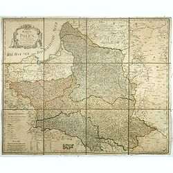
Regni Poloniae, ducatus Mazoviae et province Cujaviae / descriptio emendata per R. & I. Ottens
Very rare map of Poland Lithuania and Ukraine, etc. Engraved by A. Schut.Joachim Ottens (1663 - 1719) and his sons Renier and Joshua were prominent Dutch booksellers and ...
Place & Date: Amsterdam, 1725
Selling price: $1500
Sold in 2017

Silesiae typus..
Fine and early map of Silesia after Martin Helwig (1516-1574) and used by A.Ortelius in his atlas 'Theatrum Orbis Terrarum [Atlas of the Whole World].Only included in the...
Place & Date: Antwerp, 1598
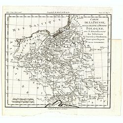
Carte de la Prusse, de la Grande et Petite Pologne, avec le démembrement des Palatinats de Cracovie et Sandomirz, faisant aujour d'hui partie de la Lodomerie.
A map of the Polish territories by Louis Brion de la Tour, from the work "Histoire universelle depuis le commencement du monde jusqu a present" published in Par...
Place & Date: Paris, 1779
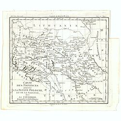
Carte des provinces annexées à la petite Pologne, et de la Gallicie, avec la Lodomerie, démembrées de la Pologne.
A map of the southern provinces of Poland by Louis Brion de la Tour, from the work "Histoire universelle depuis le commencement du monde jusqu a present" publis...
Place & Date: Paris, 1779
Ducatus Silesiae Glosani.
Charming map of the Silesia from the Mercator Hondius “Atlas Minor” published in Amsterdam in 1648 at Janssonius with German text on verso. Engraved by Petrus Kaerius...
- $200 / ≈ €187
Place & Date: Amsterdam, 1648
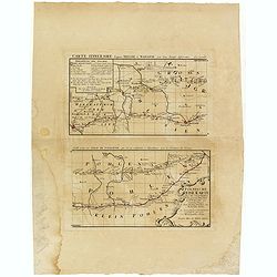
Polnische Reise Karte uber die vornehmsten Passagen von Dresden nach Warschau auf zweyerley Wegen I) uber Breslau, Peterkau und II) uber Lissa, Kaliez . . . 1751
Scarce strip-style road map showing two roads from Dresden via Glogau or Breslau to Warsaw.A key identifies villages, markets and post offices along the routes. Printed i...
Place & Date: Nurember, 1751
Poland As Divided.
This map covers Poland following Napoleonic Wars and the treaties of the 1815 Congress of Vienna.This map was first published in Thomson's New General Atlas of 1814. John...
Place & Date: Edinburgh, 1817
Mappa Geographica Regni Poloniae ex novissimis quot quot sunt mappis. . .
A map of Poland, Lithuania and Belarus, first published in 1750 by Homann Heirs, and now re-issued in 1773. Coastline includes all between Riga and Gdansk. Map is based o...
- $500 / ≈ €468
Place & Date: Nuremberg, 1773
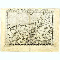
Tavola nuova di Prussia et di Livonia.
Uncommon first edition of this early map of the region from Pomerania to Livonia, includes a portion of Estonia, and coastal detail on the Baltic Sea with a small section...
- $400 / ≈ €374
Place & Date: Venice, Vincenzo Valgrisi, 1561
Tabula nova totius regni Poloniae. . .
Map of Poland, Lithuania, Latvia, Belarus and Ukraine with decorative cartouche in the upper left corner.Published by Nicolaas Visscher after N. Sanson.
- $900 / ≈ €842
Place & Date: Amsterdam, 1690

Ducatus Prussiae tam Polono Regiae. . .
This is a rare issue of Frederick de Wit's attractive map of the northern part of Poland, Prussia and the Baltic regions.Very decorative title cartouche, including three ...
Place & Date: Amsterdam, 1698
Ducatus Prussiae tam Polono Regiae. . .
Rare issue of Frederick de Wit's attractive map of the northern part of Poland, Prussia and the Baltic regions.Very decorative title cartouche including 3 coats of arms. ...
- $3500 / ≈ €3275
Place & Date: Amsterdam, 1698
Moscovie. (34).
Scarce map of Muscovy and part of Poland and Lithuania published by Antoine de Fer in 1661 or 1662 in "Cartes de géographie revues et augmentées". The series ...
- $150 / ≈ €140
Place & Date: Paris, Antoine de Fer, 1657 but 1661 or 1662
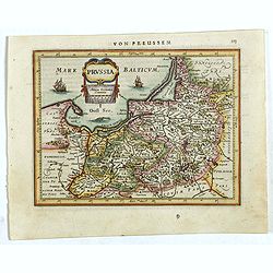
Prussia .
An early map of northern Poland from the "Atlas Minor" (Gerhard Mercator / Jodocus Hondius). Extends from Memel to Torun and the Narew River. With two sailing s...
- $300 / ≈ €281
Place & Date: Amsterdam, 1612
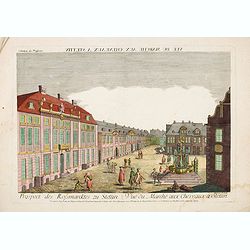
Prospect des Rossmarcktes zu Statin - Vue du Marché aux Cheveaux a Stettin.
Rare so-called optical print illustrating the Horse market of Stettin in Poland. Engraved by F. Riedel. The Academie Imperiale was a well-known publisher of optical print...
- $600 / ≈ €561
Place & Date: Augsburg, 1760
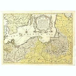
A New and Accurate Map of the Kingdom of Prussia, Pomerania, Courland & the Adjacent Parts Bordering on the Baltick Sea.
Attractive uncommon detailed map of the Kingdom of Prussia and the neighbouring regions, showing much of modern day Poland. Published in 'Universal Magazine', and well en...
- $750 / ≈ €702
Place & Date: London, 1757
Charte von Russisch Litauen, welche die von Polen an Russland Abgetretene Woiewodschaften, Liefland, Witepsk, Mscislaw, und einem Theil der Woiewodschaften Polock und Minsk Enthalt.
An uncommon map of Belarus, together with parts of the Ukraine and Lithuania. Shows the rivers Dnieper and Dwiner from Liefland to Mscislaw and Woiwodschaft.. With the to...
- $500 / ≈ €468
Place & Date: Nuremberg, 1775
Borussiae Regnum compectens Circulos Sambiensem, Natangiensem, et Hockerlandiae Nee non Borussia Polonica, exhibens Palatinatus Culmiensem. . .
Decorative map covering northern Poland with Prussia, Pomerania, Hockerlandia, Warmiaermelandia, Natanglensis, Galindia, Nandrovia, Sclavonia, and the Baltic Sea. Include...
- $400 / ≈ €374
Place & Date: Augsburg, 1759
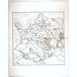
Carta del Teatro della Guerra in Polonia - 1831.
Oversized rare 1831 war map of Poland and Lithuania published during the Polish - Russian War in 1831, published by Presso l'incisore Stanislao Stucchi. Stucchi, was born...
- $900 / ≈ €842
Place & Date: Milan, 1831
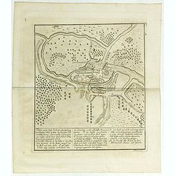
Plan von der Stadt Pullusk alwo der Konig von Sweden Carl XII den Saxischen Feldmarschall Steinau. . .
Rare plan of the Battle of Pultusk which took place on April 21, 1703 in Pultusk during the Great Northern War. The Swedish army under the command of Charles XII defeated...
- $450 / ≈ €421
Place & Date: Frakfurt, Merian heirs,1717
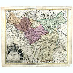
Estats de la Couronne de Pologne.
Map of Poland prepared by N.Sanson and published by F. Halma.Published in an Dutch edition of the small Sanson atlas L'Europe Dediée a Monseigneur . . . Le Tellier Secre...
Place & Date: Amsterdam, Utrecht, 1683
Estats De La Couronne De Pologne ou sont les Royaume de Pologne, Duches et Provinces De Prusse, Cuiave, Mazovie, Russie Noire &c.
Fine map of Poland, state with erased date. Engraved by J.Sommer.Nicolas Sanson was to bring about the rise of French cartography, although the fierce competition of the ...
Place & Date: Paris, 1663
Polonia.
A miniature map of the Polish-Lithuanian Commonwealth, published by Petrus Bertius, in Amsterdam at the beginning of the seventeenth century. It features a small strap-wo...
Place & Date: Amsterdam, 1606
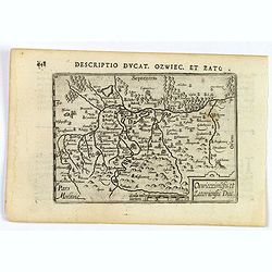
Descriptio Ducat. Ozwiec. et Zato.
An original early 17th century copper engraved miniature antique map of the Oswiecim (Auschwitz) and Zator area of southern Poland by Petrus Bertius. The title is display...
- $100 / ≈ €94
Place & Date: Amsterdam, 1606
Regnum Borussiae gloriosis auspiciis serenissimi et potentissimi princip. Friderici III primi Borussiae regis march. et elect. Brandenburg inauguratum die 18 Jan...1701.
Map covering the region along the Baltic Sea from Prussia to northern Poland, with the city of Kaliningrad (Königsberg), Danzig, and Heilsperg, etc. With a large title-c...
- $700 / ≈ €655
Place & Date: Nuremberg, 1720
Das bombadirte Dantzig. Das belagerte Danzig eine Weltberühmte Haupt und Handelstatt des Polnischen Preussens, mit ihren Vorstaedten und der Weichselmünder Schanz,
Large original copper engraving with decorative set edge, top left Diarium of the Russian attack and Russian battleships in Gdansk Bay, above list of the most important b...
- $850 / ≈ €795
Place & Date: Nuremberg, 1734
La Pologne Dressée sur ce qu'en ont donné Starovolsk, Beauplan, Hartnoch. . .
This is a late edition of the De L'Isle copper plate with a date of 1806. The copper plate was used many times and has several erased addresses. This one with address &qu...
- $750 / ≈ €702
Place & Date: Paris, 1806
Provincia ecclesiastica di Gnesna e Posnania nella Prussia Vicar.ti apost.cl di Sassonia e Dei Ducati Analtini (Tav LXXXII)
A large-format map of western Poland with its different dioceses. The map is finely engraved and beautifully colored and was prepared by Girolamo Petri, a lawyer who serv...
- $500 / ≈ €468
Place & Date: Rome, 1858
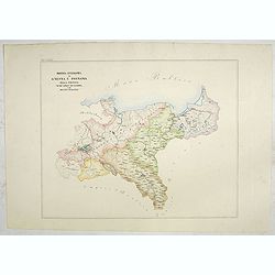
Reino de Polonia ò sea la parte unida a la Rusia por el repartimiento de 1795 que conserva el nombre de aquel antiguo reino.
Uncommon Spanish map of Poland from "Coleccion de mapas geograficos antiguos y modernos de autores clascicos", published by José Torner in Barcelona in 1831.R....
- $80 / ≈ €75
Place & Date: José Torner, Barcelona, 1831
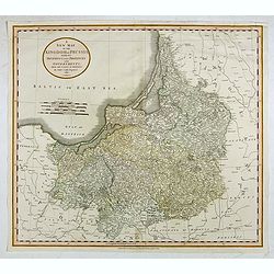
A New Map of the Kingdom of Prussia with its Divisions Into Provinces and Governments. . .
A fine map by John Cary of Prussia, in what is now northern Poland and Lithuania. John Cary was considered "the most representative, able and prolific of English car...
- $250 / ≈ €234
Place & Date: London, 1811

Prussiae Regionis Sarmatiae Europae Nobilissimae Novaet vera descriptio . . .
Nice example of the first edition of De Jode's map of Prussia, from the 1593 edition of De Jode's atlas.The present map is an entirely new addition to the second De Jode ...
- $2000 / ≈ €1871
Place & Date: Antwerp, 1593
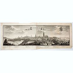
Neis in Schlesien. (Nysa)
A spectacular panoramic view of Nysa in southwestern Poland, with legends numbered from 1-23 in German. With the title in a banderol.After a design by Friedrich Bernhard ...
- $2500 / ≈ €2339
Place & Date: Augsburg, 1729
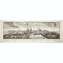
Lirgnitz. (Legnica)
A spectacular panoramic view of Legnica in southwestern Poland, in the central part of Lower Silesia, with legends numbered from 1-20 in German. With the title in a bande...
- $2500 / ≈ €2339
Place & Date: Augsburg, 1729
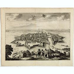
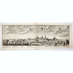
Schweidnitz. (Swidnica)
A spectacular panoramic view of Swidnica is a city in south-western Poland, with legends numbered from 1-19 in German. With the title in a banderol.After a design by Frie...
- $2500 / ≈ €2339
Place & Date: Augsburg, 1729
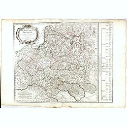
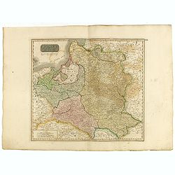
Royaume de Pologne.
Fine map of Lithuania, Prussia and Poland with an explicatif text to both sides. From Jean Baptiste Louis Clouet (1730-1790) influential "Géographie Moderne" f...
- $350 / ≈ €328
Place & Date: Paris, ca. 1767
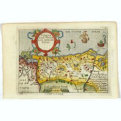
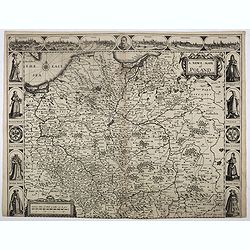
POLONIAE finitimarumque locorum descrip:tio. Auctore WENCESLAO GRODECCIO. Polono.
Ortelius' map of Poland, being a close copy of Grodecki / Pograbka's map of 1558/62 map, itself based on Wapovsky 1526 (Karrow 56) With Latin text on verso, a state 1 and...
- $1200 / ≈ €1123
Place & Date: Antwerp, 1587
Accueil Consultation Plan du Siège de Danzig par le 10me. Corps de la Grande Armée, Avec les travaux des Français, tels qu'ils étaient le 25 Avril 1807.
A map of the siege of Danzig, 19 March-24 May 1807, showing the positions of the French siege works as they stood on 23 April. Napoleonic Wars (1803-15). Oriented with so...
Place & Date: Paris, after 1810
![Partie septentrionale du cercle de Haute Saxe [...] Brandebourg.](/uploads/cache/64110-250x250.jpg)
Partie septentrionale du cercle de Haute Saxe [...] Brandebourg.
Finely and crisply engraved map of north eastern part of Germany, including part of Poland. With inset map of Brandenburg. Map by Giles Didier Robert De Vaugondy with era...
- $150 / ≈ €140
Place & Date: Paris, c. 1760
La Prusse divisée en Prusse royale, et Prusse Ducale. . .
Finely and crisply engraved map of Prussia including The Bay of Danzig. Ornamental title cartouche in the upper part of the map from his "Atlas Universel".Gille...
- $300 / ≈ €281
Place & Date: Paris, 1750

Langwasser Stanislau Neu Brandenburg Mei 1942 Juni 1945
Map met reproducties van crayontekeningen van Krijgsgevangenschap in Langwasser, Stanislau en Neu-Brandenburg, Mei 1942 -juni 1945.Uitgegeven april 1948 door het Minister...
Place & Date: Den Haag, April 1948