Browse Listings in Europe > Netherlands > Limburg
![Traiectum ad Mosam. [Maastricht]](/uploads/cache/47901-250x250.jpg)
Traiectum ad Mosam. [Maastricht]
A birds-eye view of Maastricht seen from the south. Rising on Vrijthof square is the dominant complex of Sint-Servaas, in front of which - seen here in a distorted perspe...
Date: Cologne, ca. 1581

Limburgensis Ducatus Tabula Nova.
Map of Limburg, prepared by the Antwerp expert in law and mathematics Aegidius Martini. After 1600 Jan Baptist Vrients acquired the stock and the plates of Ortelius' Thea...
Date: Antwerp, 1606-1612
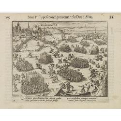
Auriaco infaelix Roermonda. . .
Showing the siege in May 1572 of Roermond.
Date: Amsterdam, 1612

Ruremunda Gelriae opp.
A bird's eye town-plan of the town of Roermond. From the first Dutch translation of Guicciardini's description of the Netherlands.
Date: Amsterdam, 1612
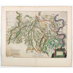
Fossa quae a Rheno ad Mosam duci caepta est Anno CLC ICCXXVII.
FIRST STATE without the coats of arms and its final title "Fossa Sanctae Mariae." - Only included in a few early editions.Detailed map of part of the country be...
Date: Amsterdam, 1634

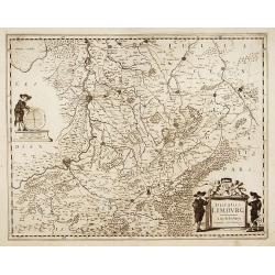
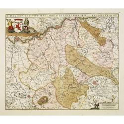
Ducatus Limburg.
A very rare issue of this map of Limburg. Cornelis Danckerts II copied the folio map of H.Hondius.The publisher's address was placed in the lower right-hand corner. The c...
Date: Amsterdam, 1636
Ducatus Limburg.
A very rare issue of this map of Limburg. Cornelis Danckerts II. copied the folio map of H.Hondius.The publisher's address was placed in the lower right-hand corner. The ...
Date: Amsterdam, 1636
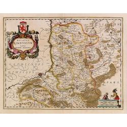
Ducatus Limburg.
In 1616 prepared by Aegidio Martini. Includes the towns of Maastricht as well as of Aachen. A very large title cartouche with two putti.
Date: Amsterdam 1639

Fossa Sanctae Mariae.
Detailed map of part of the country between rivers Rhine and Meuse showing a canal to be dug between 1626 and 1628 between Rheinberg in Germany and Venlo. A deficiency of...
Date: Amsterdam, 1645

Fossa Sanctae Mariae.
Detailed map of part of the country between rivers Rhine and Meuse showing a canal to be dug between 1626 and 1628 between Rheinberg in Germany and Venlo. A deficiency of...
Date: Amsterdam, 1645

Tabula ducatus Limburch et comitatus Valckenburch. . .
The map describes the southern part of Limburg and reaches into Belgium (Liege, Verviers) and Germany. With two very decorative cartouches.
Date: Amsterdam, 1690
Tabula ducatus Limburch et comitatus Valckenburch. . .
The map describes the southern part of Limburg and reaches into Belgium (Liége, Verviers) and Germany. With two very decorative cartouches.
Date: Amsterdam, 1690

Mastric ou Maëstricht, Ville du Brabant-Hollandois. . .
A very decorative and extremely rareof Maastricht, including a numbered key (1-23) in lower part. Engraved by Pierre-Alexandre Aveline. With "Fait par Aveline avec p...
Date: Paris, ca.1692
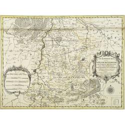
Le Limbourg ou font le duche de Limbourg. . .
Fine map of the Limburg with a decorative title and scale cartouche.Alexis-Hubert Jaillot (1632-1712), was a French cartographer. He joined the Sanson heirs and redrew Ni...
Date: Amsterdam, 1692

Tabula Episcopatuum Leodiensis et Coloniensis. . .
Rare issue of Cornelis Danckert's attractive map of Limburg, shows the area of Cologne, Mainz, Trier, Jülich, Mons, Antwerp and Liege in Belgium.Decorative title cartouch...
Date: Amsterdam, 1700
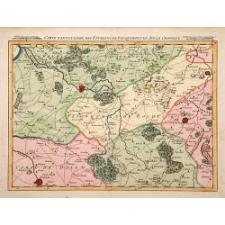
Carte particuliere des environs de Fauquemont et Aix la Chapelle.
An attractive map of the southern part of Limburg, centered on Valkenburg, Aachen, Rolduc and Dalem.
Date: Paris, 1740

Plan de la ville de Maestricht avec ses attaques commandées par M. le maréchal de Saxe, depuis le 15 avril jusqu'au 3 may 1748 . . .
A plan of Maastricht rising after the capture of the city by the French troops led by the Marshal of Saxony. The city was besieged between 15 April and 3 May 1748, during...
Date: Paris, 1781
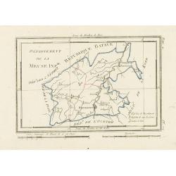
Département de la Meuse Inf.re.
Map representing the area around Maastricht, with a short key list in the lower right corner.From Atlas de la Géographie de toutes les parties du monde .. Ouvrage destiné...
Date: Paris, Prudhomme, Levrault, Debray, 1806
