Browse Listings in Europe > Greece > Greek Islands
![[Euboe].](/uploads/cache/41989-250x250.jpg)
[Euboe].
Woodcut Ptolemaic-style map by Sebastian Münster figuring Euboea Island, published in the edition of Strabo by Henri Petri in 1571."Strabonis rerum geographicarum&qu...
Date: Basle, Henri Petri, 1571
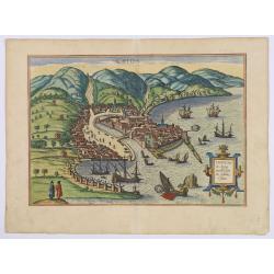
Chios.
The engraving shows the seaport of Chora, the capital of Chios, as seen from the east in a bird's-eye view.
Date: Cologne, ca 1588
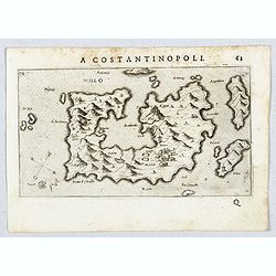
Millo.
Very rare view of Milos Island published in the first edition of "Viaggio da Venetia, a Costantinopoli. Per Mare, e per Terra, & infieme quello di Terra Santa. D...
- $450 / ≈ €393
Date: Venice, Giacomo Franco, 1598
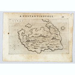
Murgo.
Very rare map of Amorgos published in the first edition of "Viaggio da Venetia, a Costantinopoli. Per Mare, e per Terra, & infieme quello di Terra Santa. Da Gios...
- $300 / ≈ €262
Date: Venice, Giacomo Franco, 1598

Metileme. (Lesbos)
Very rare map of Lesbos published in the first edition of "Viaggio da Venetia, a Costantinopoli. Per Mare, e per Terra, & infieme quello di Terra Santa. Da Giose...
Date: Venice, Giacomo Franco, 1598

Scio. (Chios)
Very rare view of Chios Island published in the first edition of "Viaggio da Venetia, a Costantinopoli. Per Mare, e per Terra, & infieme quello di Terra Santa. D...
Date: Venice, Giacomo Franco, 1598
![Stampalia. [Map of Astypalaia]](/uploads/cache/45244-250x250.jpg)
Stampalia. [Map of Astypalaia]
Very rare map of the Greek island Astypalaia. The island is known in Italian as Stampalia. Published in the first edition of "Viaggio da Venetia, a Costantinopoli. P...
Date: Venice, Giacomo Franco, 1598

Santorini.
Very rare map of Santorini published in the first edition of "Viaggio da Venetia, a Costantinopoli. Per Mare, e per Terra, & infieme quello di Terra Santa. Da Gi...
Date: Venice, Giacomo Franco, 1598
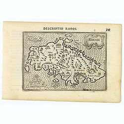
![Rhodi [Map of Rhodes]](/uploads/cache/45235-250x250.jpg)
Rhodi [Map of Rhodes]
Very rare map of Rhodes Island published in the first edition of "Viaggio da Venetia, a Costantinopoli. Per Mare, e per Terra, & infieme quello di Terra Santa. D...
Date: Venice, Giacomo Franco, 1598
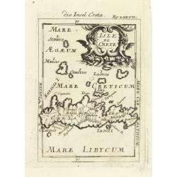
![Candia [Map of Crete]](/uploads/cache/45233-250x250.jpg)
Candia [Map of Crete]
1598 ROSACCIO, Giuseppe. Small map of the island Crete, published in the first edition of "Viaggio da Venetia".
Date: Venice, Giacomo Franco, 1598
![[Map of Morea]](/uploads/cache/45228-250x250.jpg)
[Map of Morea]
Very rare map of the island Morea published in the first edition of "Viaggio da Venetia, a Costantinopoli. Per Mare, e per Terra, & infieme quello di Terra Santa...
- $450 / ≈ €393
Date: Venice, Giacomo Franco, 1598
![[Map of Corfu. View of the city of Corfu on the foreground. ]](/uploads/cache/45221-250x250.jpg)
[Map of Corfu. View of the city of Corfu on the foreground. ]
Very rare map of Corfu with a view of the city of Corfu on the foreground. Published in the first edition of "Viaggio da Venetia, a Costantinopoli. Per Mare, e per T...
Date: Venice, Giacomo Franco, 1598
![[Map of Zakynthos or Zante]](/uploads/cache/45226-250x250.jpg)
[Map of Zakynthos or Zante]
Very rare map of Zakynthos or Zante, a Greek island in the Ionian Sea. It is the third largest of the Ionian Islands. Published in the first edition of "Viaggio da V...
- $450 / ≈ €393
Date: Venice, Giacomo Franco, 1598
Rhodi.
A beautiful miniature map of the Greek island of Rhodes, published by Petrus Bertius in Amsterdam at the beginning of the seventeenth century.Engraved by Petrus Kaerius. ...
Date: Amsterdam, 1606
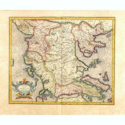
Marcedonia epirus et Achaia.
A fine early map of present day Macedonia with the island of Corfu and northern part of Greece. The standard for maps of the region for most of the 17th century. It is ba...
- $300 / ≈ €262
Date: Amsterdam, 1628
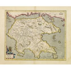
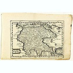
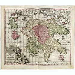
Morea olim Peloponnesus.
Gerard Mercator's map of the Greece's Peloponnesus peninsula called and labeled Morea. A few of the other smaller islands appear included the larger Cerigo (today's Cythe...
Date: Amsterdam, 1630
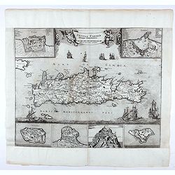
Candia cum Insulis aliquot circa Graeciam.
An attractive (if rather inaccurate) map of Crete, with insets of the islands of Corfu, Zante, Milos, Nicsia, Santorini, and Scarpanto.
Date: Amsterdam, ca 1636
![[Map of the coast of Crete to the east of Chania showing the landing of the Turks and the Venetian defence in June 1645].](/uploads/cache/49076-250x250.jpg)
[Map of the coast of Crete to the east of Chania showing the landing of the Turks and the Venetian defence in June 1645].
Map engraved by Marco Boschini (1613-1678). With a lettered key for the Turkish army « A-L » and a numbered key for the city of Chania and its army « 1-20 ».Fifth Otto...
Date: Venice, c. 1645
Il Regno Di Candia.
This rare map is based on the important map of Crete by Basilicata. The maps by Marco Boschini reached a wider audience than the few individuals for whom the Basilicata m...
Date: Venice, 1660
Moree jadis Peloponese.
Rare map of Peloponnese, published by Jollain in 1667. Published in "Trésor Des Cartes Geographiques Des Principaux Estats de Lunivers".This atlas is based upon...
- $300 / ≈ €262
Date: Paris, 1667
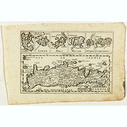
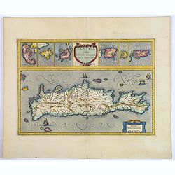
Candie.
Rare map of Crete with in top six small inset maps of Greek islands, published by Jollain in 1667. Published in "Trésor Des Cartes Geographiques Des Principaux Estat...
- $350 / ≈ €306
Date: Paris, 1667
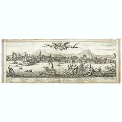
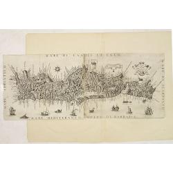
Candie.
A panoramic view, showing the Turkish siege of Candia, with a numbered key (1-33) at the bottom locating 33 points of interest. of Crete coast and the Turkish vessels (33...
Date: Amsterdam, ca. 1678

Ignographia candiae tertia a turcis obsessae in lucem edita a F. de Wit.
A scarce broadsheet plan and view of Heraklion on one sheet: prospect 180 x 495mm, map 395 x 495mm., in the lower part a printed description "Abbildung der starken S...
Date: Amsterdam, 1680
Insula Candia ejusque fortificatio.
An earlier and smaller version of De Wit's map of Candia. Richly engraved work, one of the most beautiful ever produced of Crete. There are insets of the fortifications a...
- $2500 / ≈ €2186
Date: Nuremberg, 1680
Isle de Crete.
A charming late 17th century map of the Island of Crete. By Allain Manneson Mallet (1630-1706), a well traveled military engineer and geographer who worked in 17th centur...
Date: Frankfurt, 1684
Peloponnesus Hodie Morea Ad Normam Veterum Et Recentiorum Mappa Accuratissime Adornata Aeri Incisa Et Venalis. . .
Decorative regional map of Morea and contiguous islands, with an ornate cartouche showing a lion bearing a sword defeating Turkish and other invaders.
Date: Augsburg, 1740
![[56] I.Scio.](/uploads/cache/12828-250x250.jpg)
[56] I.Scio.
"Charming chart of the harbour of the Greek town of Chios. Showing town and harbour plan, with soundings, anchorages, rocks, shoals, fortifications and lighthouses.J...
Date: Marseille, 1764
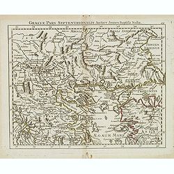
Graeciae pars septentrionalis. . .
Rare map of northern part of Greece and part of Turkey, prepared by Nolin and published by L.J. Mondhare for his Atlas Général a l'usage des colleges et maisons d'educati...
Date: Paris, 1781
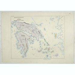
Provincia ecclesiastica di Naxos e delegazione aplica di Grecia. (Tav XCVII)
A large-format map of Naxos with it's dioceses. This Greek island in the South Aegean, is the largest of the Cyclades island group. The map is finely engraved and beautif...
- $250 / ≈ €219
Date: Rome, 1858
Provincia ecclesiastica di Corfu nell isole Jonie. Tav. XCV.
A large-format map centered on Corfu with it's dioceses. The map is finely engraved and beautifully colored and was prepared by Girolamo Petri, a lawyer who served as a s...
- $450 / ≈ €393
Date: Rome, Tipografia della Reverenda Camera Apostolica, 1858-1859
