
Tableau des guerres de Frédéric le Grand: ou plans figurés de vingt-six batailles rangées, ou combats essentiels donnés dans les trois guerres de Silésie. . .
The book includes a large folded map "Tableaux des Guerres de Frédéric le Grand", showing a map of Prussia, with present-day Poland and Eastern Germany surrou...
Place & Date: Potzdam, Strasbourg, Paris, 1788

Germania.
Second state of this rare "carte à figures"- map of Germany, The Netherlands, Poland and central Europe. Bordered on three sides with portraits and views. In t...
Place & Date: Amsterdam, 1607

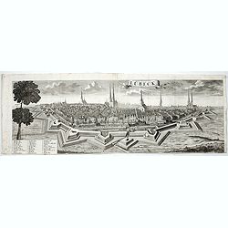
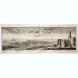
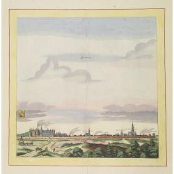
(Lübeck) Lvbeca vrbs. imperialis libera. civitatvm. Wandalicarvm. . . .
Impressive more than 3 meters wide panoramic town view after a woodblock engraving from Elias Diebel, initially made in 1552. Of this original woodblock, Bachmann mention...
- $4500 / ≈ €4211
Place & Date: Germany, c. 1855

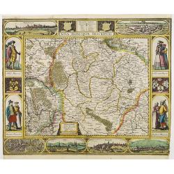
Nova Germaniae Descriptio..
A finely engraved carte à figures, with the side borders depicting emperors, while the upper and lower panels contain finely engraved miniature town prospects, among the...
Place & Date: Amsterdam, 1632

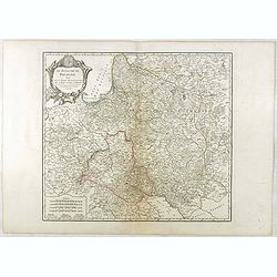
Palatinatus Rheni Nova et Accurata Descriptio.
Early state (1630) of Visscher's "carte à figures"- map of the German Rhine River Valley. Inset views of Frankfurt am Main, Mainz, Speyer, Worms and Heidelberg...
Place & Date: Amsterdam, 1630
Nova Franconiae Descriptio.
In 1626 Abraham Goos engraved a single-sheet "carte à figures"- map of Franconia with decorative borders for Joannes Janssonius. In the center part of the top ...
- $3000 / ≈ €2807
Place & Date: Amsterdam, 1626
![Ulma Folio CXCI [With view of Ulm.]](/uploads/cache/29713-250x250.jpg)
Ulma Folio CXCI [With view of Ulm.]
Double page panoramic view of Ulm.A imaginary view, however the earliest obtainable view of this period.Two page from the richest illustrated Incunabel, the famous: Nurem...
Place & Date: Nuremberg, 12 July 1493

Carte du Palatinat du Rhin.
Decorative "carte à figures"- map centered on Koblenz, Metz, Strasburg, Manheim and Heidelberg, with the river Rhine by François Jollain (ca. 1641 – 18 Apri...
Place & Date: Paris, ca. 1688

Campagne du Roi de Prusse de 1778 à 1779.
The book is illustrated with a two-sheet folding map "Carte d'une partie du Royaume de Bohême et de la Moravie ainsi que d'une partie de la Silésie". Prepared...
Place & Date: Geneva, Paris, Mérigot le jeune, 1784
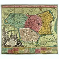
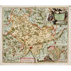
![Tabula electoratus Brandenburgici, Meckelenburgi, et maximae partis Pomeraniae, ex variis, famosissimisq[ue] auctoribus summo studio concinnata. . .](/uploads/cache/29543-250x250.jpg)
Tabula electoratus Brandenburgici, Meckelenburgi, et maximae partis Pomeraniae, ex variis, famosissimisq[ue] auctoribus summo studio concinnata. . .
Uncommon "carte à figures"- map engraved by the master engraver Abraham Goos and published by Claes Jansz. Visscher (1587-1652). Showing the area of Brandenbur...
Place & Date: Amsterdam, 1630

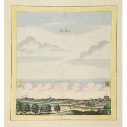
Wittstocs.
Very decorative and rare panoramic of Wittstock, Bez. Potsdam.The engraver and publisher of prints, Mrs. Anna Beek of the Hague, enlarged the print and mounted it on larg...
Place & Date: The Hague, ca. 1642

Norimberga.
A spectacular panoramic of Nuremberg, with legends numbered from 1-39 in German. With the title in a banderol.After a design by Friedrich Bernhard Werner (1690-1776) who...
Place & Date: Augsburg, ca. 1720

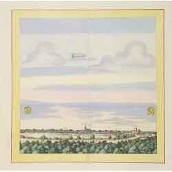
Tschopau.
Very decorative and rare panoramic of Tschopau.The engraver and publisher of prints, Mrs. Anna Beek of the Hague, enlarged the print and mounted it on larger paper: she ...
Place & Date: The Hague, ca. 1700
![Sexta Etas Mundi. Ratisbonna. [Ratisbonne]](/uploads/cache/13549-250x250.jpg)
Sexta Etas Mundi. Ratisbonna. [Ratisbonne]
A very fine presentation of the city of Ratisbon, in Germany, centered on the cathedral (Dim. : 191 mm W : 525 mm).Overleaf a very nice view of Vienna, with two swans on ...
Place & Date: Nuremberg, 12 July 1493
Carte du cours du Rhin dpuis le fort de Schengen jusqu'à Lauterbourg. . .
Beautiful manuscript map of the region around Rastatt and the siege of 1714 signed with the French emperor Charles VI of Habsburg. In top with a small extension of the ma...
Place & Date: Germany, France, c. 1714
![Monacum. [Munich Folio CCXXVI ]](/uploads/cache/14365-250x250.jpg)
Monacum. [Munich Folio CCXXVI ]
A very fine representation of the city of Munich.Page from the richest illustrated Incunable, the famous: Nuremberg Chronicle, published the year that Columbus returned t...
- $2500 / ≈ €2339
Place & Date: Nuremberg, 12 July 1493

Germaniae Nova ac Accurata Descriptio.
This "carte à figures"- map covers the Low Countries, Germany, Poland, Switzerland and Austria. Overall a very good copy of this excellently engraved, uncommon...
Place & Date: Amsterdam, 1642

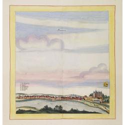
Volna.
Very decorative and rare panoramic town-view of Volna. We have more Anna Beek prints available.The engraver and publisher of prints, Mrs. Anna Beek of the Hague, enlarg...
Place & Date: The Hague, ca. 1700

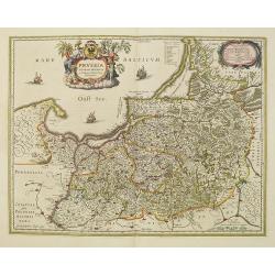
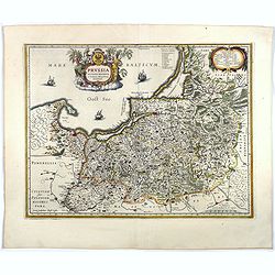
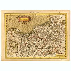
Prussiae Regionis Sarmatiae Europae Nobilissimae Novaet vera descriptio . . .
Nice example of the first edition of De Jode's map of Prussia, from the 1593 edition of De Jode's atlas.The present map is an entirely new addition to the second De Jode ...
- $2000 / ≈ €1871
Place & Date: Antwerp, 1593
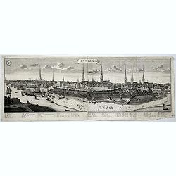
Hamburg.
A spectacular panoramic view of Hamburg, with legends numbered 1-19 and A-Z in German. With the title in a banderol.After a design by Friedrich Bernhard Werner (1690-1776...
- $2000 / ≈ €1871
Place & Date: Augsburg, 1729

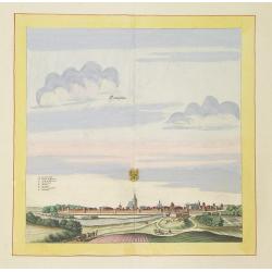
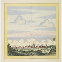
Alssleben.
The engraver and publisher of prints, Mrs. Anna Beek of the Hague, enlarged the print and mounted it on larger paper: she colored it in pastel colors, adding extensive cl...
Place & Date: The Hague, ca. 1700
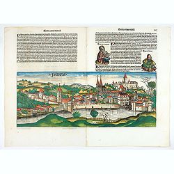
Bamberga. Folium CLXXV
Double page panoramic view of Bamberg. One of the earliest obtainable view of this period.Two page from the richest illustrated Incunable, the famous: Nuremberg Chronicl...
Place & Date: Nuremberg, 12 July 1493

Wandkarte des Deutsches Reiches zum Schul und Comptoir-Gebrauch. . .
School wall map of Germany, Poland, Low Counties, Bohemia printed in chromo lithography with contemporary hand coloring to borders. Published by "Stich und Druck der...
Place & Date: Berlin, Dieter Reimer, 1878

Typus Frisiae Orientalis à Dullarto
One of the most decorative maps of East Frisia and its important shipping center of Emden and the Watten Islands, from the cartography of Ubbo Emmius, a local cartographe...
Place & Date: Amsterdam, ca. 1624

Magnae Prussiae Ducatus Tabula denuo correcta et in lucem edita per Nicolaum Visscher.
Striking old color example of Visscher's map of Prussia and part of the Baltic region. Includes a gorgeous cartouche and banner key held aloft by 2 cherubs, plus 4 sailin...
- $1500 / ≈ €1404
Place & Date: Amsterdam, 1690
Heidelberg.
A spectacular panoramic view of Heidelberg, with legends numbered from 1-72 in German. With the title in a banderol.After a design by Friedrich Bernhard Werner (1690-1776...
- $1500 / ≈ €1404
Place & Date: Augsburg, 1729
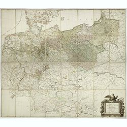
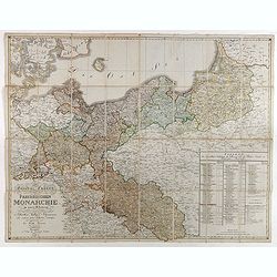
General Karte von den saemtlichen Kšnig. Preussischen Staaten welche zugleich als POSTKARTE durch die Länder der Preussischen Monarchie und durch ganz Deutschland diendt. . .
Large wall map (1,25 x 1,38 meters) of Prussia and present-day Poland, prepared by D.F. Sotzmann and published by Königl. Preuss. Academie Kunst und Buchhandlung.A detai...
- $1500 / ≈ €1404
Place & Date: Berlin, 1802

Lindau im Boden = See.
A spectacular panoramic view of Lindau on Lake Constance (or Bodensee) in Bavaria, with legends numbered 1-20 in German. With the title in a banderol. In the center its o...
- $1500 / ≈ €1404
Place & Date: Augsburg, 1729
![Sexta Etas Mundi. Constancia. [Constance CCXLI ]](/uploads/cache/33141-250x250.jpg)
Sexta Etas Mundi. Constancia. [Constance CCXLI ]
A very fine town view of Constance, in Germany, centered on the cathedral (198 x 520 mm).VERSO, seven insets of scientists, noblemen and Popes.Page from the richest illus...
- $1250 / ≈ €1170
Place & Date: Nuremberg, 12 July 1493
Lübeck.
A spectacular panoramic view of Lübeck, with legends numbered 1-28 in German. With the title in a banderol.After a design by Friedrich Bernhard Werner (1690-1776) who wa...
- $1500 / ≈ €1404
Place & Date: Augsburg, 1729
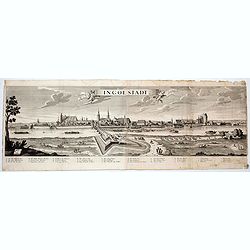
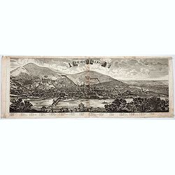
Ingolstadt.
A spectacular panoramic view of Ingolstadt in Bavaria, with legends numbered from A-P and 1-6 in German. With the title in a banderol.After a design by Friedrich Bernhard...
- $1500 / ≈ €1404
Place & Date: Augsburg, 1729

Hamburgum.
Engraved bird's-eye town-plan of Hamburg, two keys below. Frederick de Wit published after 1694 a town book of European and Asian cities (Theatrum Praecipuarum Totius Eur...
Place & Date: Amsterdam, ca. 1694
Bamberg in Francken.
A spectacular panoramic view of Bamberg, with legends numbered from 1-24 in German. With the title in a banderol.After a design by Friedrich Bernhard Werner (1690-1776) w...
- $1500 / ≈ €1404
Place & Date: Augsburg, 1729
Stättlein Frohsa.
Very decorative and rare panoramic town view of Frohse a.d. Elbe, Bez. Magdeburg.The engraver and publisher of prints, Mrs. Anna Beek of the Hague, enlarged the print and...
Place & Date: The Hague, ca. 1700
Eilenburg.
Very decorative and rare panoramic view of Eilenburg a.d. Mulde.The engraver and publisher of prints, Mrs. Anna Beek of the Hague, enlarged the print and mounted it on la...
Place & Date: The Hague, ca. 1700
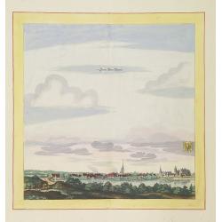
Statt Garleben.
Very decorative and rare panoramic town view of Gardelegen in Altmark.The engraver and publisher of prints, Mrs. Anna Beek of the Hague, enlarged the print and mounted it...
Place & Date: The Hague, ca. 1700
Stättl Zedenick.
Very decorative and rare panoramic town view of Zedenick a.d. Havel, Bez. potsdam.The engraver and publisher of prints, Mrs. Anna Beek of the Hague, enlarged the print an...
Place & Date: The Hague, ca. 1700
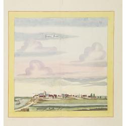
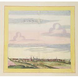
Calvorde.
Very decorative and rare panoramic of Calvörde, Bez. Magdeburg.The engraver and publisher of prints, Mrs. Anna Beek of the Hague, enlarged the print and mounted it on l...
Place & Date: The Hague, ca. 1700
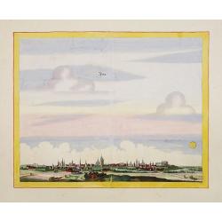
Newenwedel.
Very decorative and rare panoramic town view of Newenwedel i.d. Neumark .The engraver and publisher of prints, Mrs. Anna Beek of the Hague, enlarged the print and mounted...
Place & Date: The Hague, ca. 1700
Templin
Very decorative and rare panoramic town view of Templin in Uckermark.The engraver and publisher of prints, Mrs. Anna Beek of the Hague, enlarged the print and mounted it ...
Place & Date: The Hague, ca. 1700
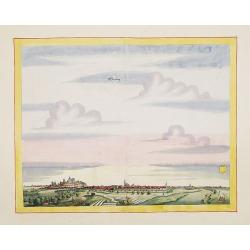
Seehaüsen.
Very decorative and rare panoramic of Seehausen, Altmark, Bez. Magdeburg .The engraver and publisher of prints, Mrs. Anna Beek of the Hague, enlarged the print and mount...
Place & Date: The Hague, ca. 1700
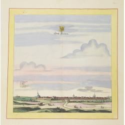
Stendalia Stendel
Very decorative and rare panoramic town view of Stendal, Bez. Magdeburg.The engraver and publisher of prints, Mrs. Anna Beek of the Hague, enlarged the print and mounted ...
Place & Date: The Hague, ca. 1700
Statt Alten Rüppin.
Very decorative and rare panoramic town-view of Statt Alten Rüppin.The engraver and publisher of prints, Mrs. Anna Beek of the Hague, enlarged the print and mounted it o...
Place & Date: The Hague, ca. 1700
Stättlein Saltza.
Very decorative and rare panoramic town view of Salzelmen Bad Salzemen, Bez. Magdeburg. The engraver and publisher of prints, Mrs. Anna Beek of the Hague, enlarged the pr...
Place & Date: The Hague, ca. 1700
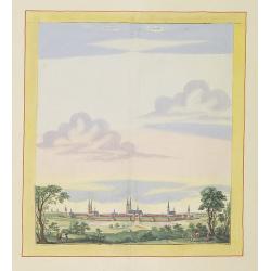
Zerbst.
Very decorative and rare panoramic town view of Zerbst in Bez, Magdeburg.The engraver and publisher of prints, Mrs. Anna Beek of the Hague, enlarged the print and mounted...
Place & Date: The Hague, ca. 1700
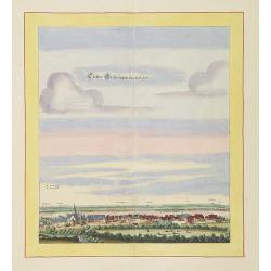
Gloster Brüningen bei Halberstatt.
Very decorative and rare panoramic town view of Halberstatt.The engraver and publisher of prints, Mrs. Anna Beek of the Hague, enlarged the print and mounted it on larger...
Place & Date: The Hague, ca. 1700
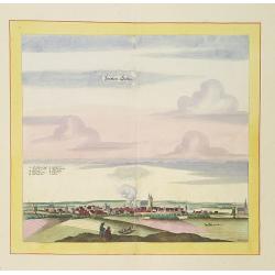
Döblen.
Very decorative and rare panoramic of Döblen in Sachsen.The engraver and publisher of prints, Mrs. Anna Beek of the Hague, enlarged the print and mounted it on larger p...
Place & Date: The Hague, ca. 1700
Statt und Ambtt Wantzleben.
Very decorative and rare panoramic town view of Wanzleben, Bez. Magdeburg.The engraver and publisher of prints, Mrs. Anna Beek of the Hague, enlarged the print and mounte...
Place & Date: The Hague, ca. 1642
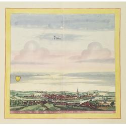
Schweet.
Very decorative and rare panoramic town view of Schwedt a.d Oder, Bez. Frankfurt a.d. Oder.The engraver and publisher of prints, Mrs. Anna Beek of the Hague, enlarged the...
Place & Date: The Hague, ca. 1642
Accurata recens delineata ichnographia celeberrimæ liberæ Imperii civitatis ac Sueviæ metropolis Agustæ Vindelicorum -Neu verfertigt accurater ... Haupt Stadt Augspurg.
Superb plan of the fortified town of Augsburg, brilliantly colored at the time, with title in Latin and German. The plan was designed by Johann Thomas Kraus, engraver, ar...
- $1200 / ≈ €1123
Place & Date: Nuremberg, ca. 1740
General Charte der Preussischen Monarchie in zwey Blattern. . .
Uncommon and detailed map of Kingdom of Prussia with present day Poland and Germany. Uncommon map engraved by Ludwig Hess and published in Weimar by Fr. Wilhelm Streit.
- $1000 / ≈ €936
Place & Date: Weimar, 1812
![Madeburga [ Maagdenburg Folio CLXXX ]](/uploads/cache/12338-250x250.jpg)
Madeburga [ Maagdenburg Folio CLXXX ]
Double-page panoramic view of Magdeburg. A imaginary view, however the earliest obtainable view of this period.Two page from the richest illustrated Incunable, the famous...
Place & Date: Nuremberg, 12 July 1493
La Prussia Divisa in Reale Che Appartiene al Ré Di Polonia et in Ducale Che Spetta all'Elettore Di Brandeburgo. Da Giacomo Cantelli Da ...
In the upper left-hand corner a large title cartouche with a dedication to Cardinal Denhoff. The map is dated 1689.The cartographer was Giacomo Cantelli (1643-1695) who w...
- $1000 / ≈ €936
Place & Date: Rome, 1689

Coloniensis Archiepisscopatus.
Extremely rare first edition of this beautiful map of Cologne and Dusseldorff.Jodocus Hondius Jr. planned to produce a new modern atlas less dependent on the Mercator pla...
Place & Date: Amsterdam, 1629

Leisnig.
Very decorative and rare panoramic town view of Leisnig a.d. Freiberger Mulde.The engraver and publisher of prints, Mrs. Anna Beek of the Hague, enlarged the print and m...
Place & Date: The Hague, ca. 1642
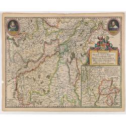
Prussia accurate descriptia a Gasparo Henneberg Erlichensi.
Prussia and the Baltic Region, with two large decorative cartouches, coat of arms and three sailing ships. As indicated in the title cartouche, the map was prepared by th...
- $900 / ≈ €842
Place & Date: Amsterdam, 1660
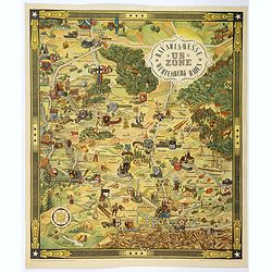
US ZONE. Bavaria, Hesse, Wurtemberg, Baden.
An unusual decorative pictorial map, from the years immediately following World War II, depicting the American Zone of Occupation in southern Germany. It portrays rural ...
Place & Date: Munich, 1940

Oost-Frise, ou Le Comté d'Embden . . .
Fine map of East Friesland with a decorative cartouche and small scale of miles.Alexis-Hubert Jaillot (1632-1712), was a French cartographer. He joined the Sanson heirs a...
Place & Date: Amsterdam, 1692
Monasteriensis Episcopatus.
The extremely rare first edition of this beautiful map of Munster.Jodocus Hondius Jr. planned to produce a new modern atlas less dependent on the Mercator plates that his...
Place & Date: Amsterdam, 1629
De Hertochdommen Gulick Cleve Berghe en de Graefschappen...
It is one of Blaeu's early maps: It was only published between 1630 and 1635 in three editions of the "Appendix" and one of the "Theatrum". In the lef...
Place & Date: Amsterdam, 1635
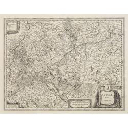
Sueviae Nova Tabula.
Extremely rare first edition of this beautiful map of Swaben, including Ulm, Augsburg, Stuttgart, Zurich, Lucerne and Lake Constance.Jodocus Hondius Jr. planned to produc...
Place & Date: Amsterdam, 1629
Le Royaume De Pologne, divise selon les Partages faits en 1772, 1793 et 1795, etnre la Russie, la Prusse et l'Autriche . . .
The uncommon later edition of this detailed map of Poland, showing the lands lost to Russia, Prussia and Austria in 1772, 1793 and 1795. with a color key added underneath...
- $600 / ≈ €561
Place & Date: Paris, ca. 1796
PATAVIA (Passau, Germ)
From the first Latin text edition, 1493. The view of PATAVIA (nowadays the city of Passau, Southern Germany) was part of the Liber Chronicarum cum figuris et ymagibus ...
Place & Date: Nuremberg, Germany, 1493
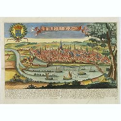
Treves. (Trier)
Rare and decorative view of Tier with the river Meuse in the foreground. Underneath a historical description of the town in Latin and French. The description mentions abo...
- $1000 / ≈ €936
Place & Date: Paris, 1680
Neue Karte des Kuhrfürstenthums Sachsen. . .
Scarce road map, first published by Peter Schenk II (1698-1775) in his "Neuen Sächsischen Atlas". It is based on a map already created and 1732 and improved in...
- $750 / ≈ €702
Place & Date: Amsterdam, 1758
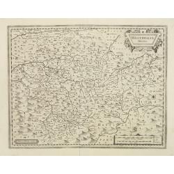
Westphalia Ducatus.
Extremely rare first edition of this beautiful map of Westphalia.Jodocus Hondius Jr. planned to produce a new modern atlas less dependent on the Mercator plates that his ...
Place & Date: Amsterdam, 1629
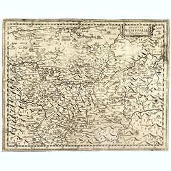
Ducatus Westphaliae Cum annexis.
Extremely rare map of Westphalia sold separately and later included in the first Regional Atlas "Prodomus Geographicus, hoc est archiepiscopatus Coloniensis annexaru...
- $1000 / ≈ €936
Place & Date: Cologne, F. Hogenberg, ca. 1620
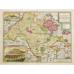
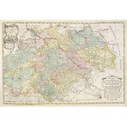
Das Bisthum Wurtzburg in Francken.
Rare map of Würzburg. With inset panoramic views of Würzburg and Köningshofen.The map is painted in strong colors. Clearly from an show-piece atlas produced for a weal...
- $1000 / ≈ €936
Place & Date: Nurenberg 1698
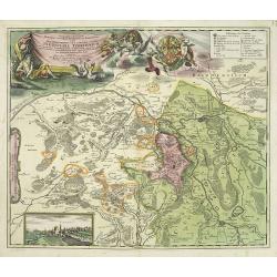
Geographica descriptio Montani cujusdam districtus in ..
Detailed map including the towns of Thurnau, Bayreuth, Culmbach, etc. With fine panoramic view of Thurnau. Upper left and right splendid title cartouches.The map is paint...
Place & Date: Nurenberg, 1710

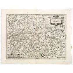
Landgraviatus Alsatiae tam superioris..
Alsace, in the far north-eastern corner of France, stands out from other French wine regions thanks to its strong Franco-Germanic influences. Alsace is the only French wi...
Place & Date: Nurenberg, 1710
Prussia accurate descriptia a Gasparo Henneberg Erlichensi.
Prussia and the Baltic Region, with two large decorative cartouches, coat of arms, and three sailing ships. As indicated in the title cartouche, the map was prepared by t...
Place & Date: Amsterdam, 1644
Selling price: $500
Sold in 2017
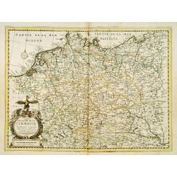
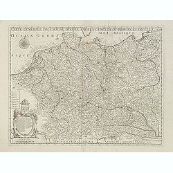
Carte Generalle de la Germanie.
A rare map of the whole Germany. Very decorative title cartouche on the lower left-hand corner.With the mention A Paris chez Nicolas Berey Enlumineur de la Reine, Demeura...
- $1000 / ≈ €936
Place & Date: Paris, 1638
Newstatt an der Orla.
Very decorative and rare panoramic of Neustadt a.d. Donau, Kr. Kelheim, Ndb.The engraver and publisher of prints, Mrs. Anna Beek of the Hague, enlarged the print and mou...
Place & Date: The Hague, ca. 1642

Greüssen.
Very decorative and rare panoramic town view of Greussen (Thür.),Bez. Erfurt .The engraver and publisher of prints, Mrs. Anna Beek of the Hague, enlarged the print and m...
Place & Date: The Hague, ca. 1642
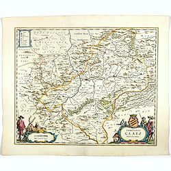
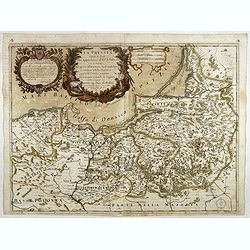
Comitatus Glatz.
Nice map by Willem Blaeu of the Silesia region with Glatz (Klodzko) at center. The forested region was renowned for its wild game and the map includes tiny illustrations ...
- $450 / ≈ €421
Place & Date: Amsterdam, 1644
Prussia.
An attractive, detailed and early map of present-day Poland and Lithuania. From the Cloppenburg edition slightly larger format and more scarce edition of the Mercator/Hon...
- $450 / ≈ €421
Place & Date: Amsterdam, 1630
Nova et accurata Territorii Ulmensis cum dominio Wainensi..
"Showing the area of Ulm. In lower part inset map of property ""zu Wein"". Upper right splendid title cartouche.The map is painted in strong and ...
- $500 / ≈ €468
Place & Date: Nurenberg 1720
![Map of the Occupied Areas. Carte des Zones d'Occupation. Der Besatzungs-Zonen mit Neuen Postleitgebieten. Karta Okkupacionnych Zon [in Cyrillic.]](/uploads/cache/42060-250x250.jpg)
Map of the Occupied Areas. Carte des Zones d'Occupation. Der Besatzungs-Zonen mit Neuen Postleitgebieten. Karta Okkupacionnych Zon [in Cyrillic.]
A poster map of Germany and Austria showing the Allied occupation zones as agreed at the Potsdam Conference after the end of the Second World War, with an inset detail of...
- $350 / ≈ €328
Place & Date: Frankfurt-am-Maine: Atlanta-Service, 1946
Carte générale d'Alemagne divisée par les cercles ou provinces d'icelle.
Rare and detailed map of Germany, Poland and Austria, engraved by H. le Roy in 1643 or 1666 for Jacques L'Agniet. Published by François Jollain (ca. 1641 – 18 April 17...
- $450 / ≈ €421
Place & Date: Paris, 1689
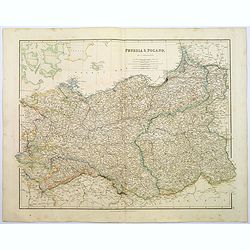
Prussia & Poland.
A glorious, large steel engraved map of Prussia and Poland. Some of the states covered are: Saxony, Pomerania, Posen, Brandenburg, Western & Eastern Prussia and the K...
Place & Date: London, 1839