
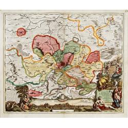
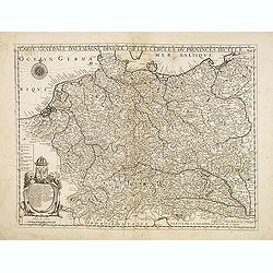
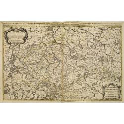
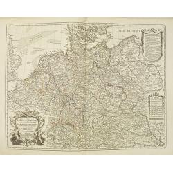
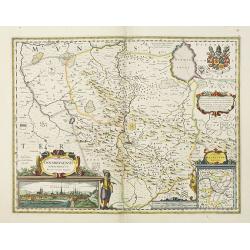
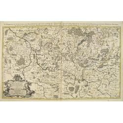
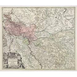
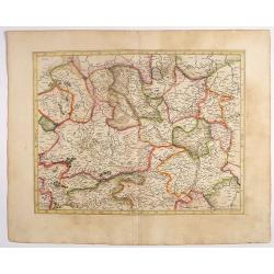
Carte de L'Empire d'Alemagne par P. Duval. . .
Uncommon map of Germany and the eastern part of Poland. In upper right corner a dedicational cartouche with coat of arms and dedication to Saint-Laurens.
Place & Date: Paris, 1676
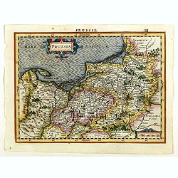
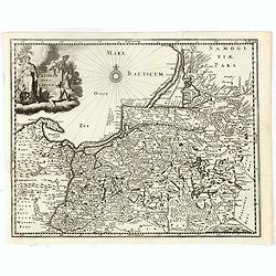
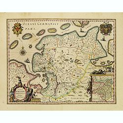
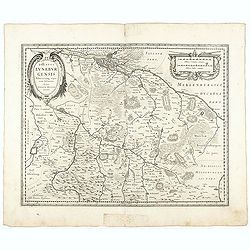
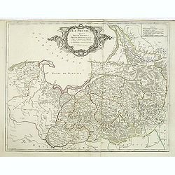
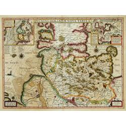
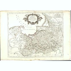
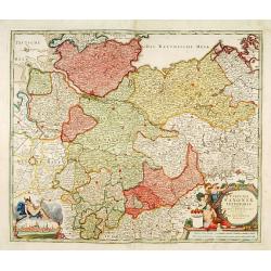
Prussia.
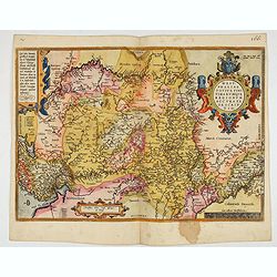
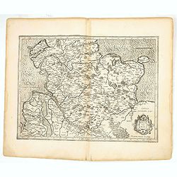
An attractive, detailed and early map of present-day Poland and Lithuania from the rare Cloppenburg edition slightly larger format and more scarce edition of the Mercator...
Place & Date: Amsterdam, 1630
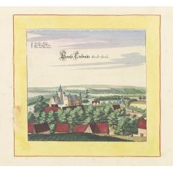
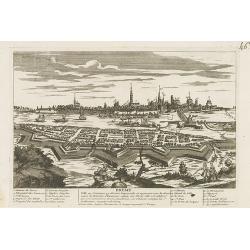
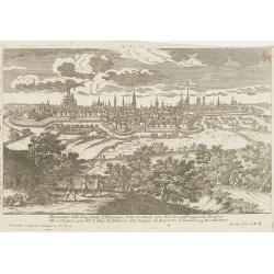
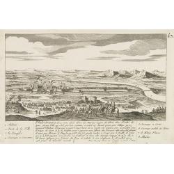
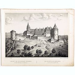
Haus trebnits an der saale.
Very decorative and rare panoramic of Trebnitz a.d Saale , Bez. Halle.The engraver and publisher of prints, Mrs. Anna Beek of the Hague, enlarged the print and mounted i...
Place & Date: The Hague, ca. 1642
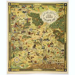
US ZONE. Bavaria, Hesse, Wurtemberg, Baden.
An unusual decorative pictorial map, from the years immediately following World War II, depicting the American Zone of Occupation in southern Germany. It portrays rural ...
- $450 / ≈ €421
Place & Date: Munich, 1940
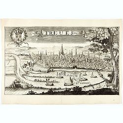
Treves (Trier)
Rare and decorative view of the city of Trier and the river Moselle in the foreground. In the upper left corner the coat of arms of France. The Jollain family was a famil...
- $400 / ≈ €374
Place & Date: Paris, 1680
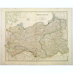
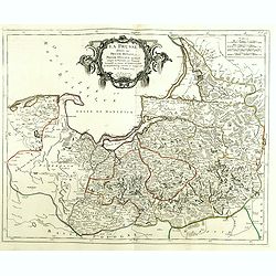
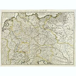
Prussia & Poland.
A glorious, large steel engraved map of Prussia and Poland. Some of the states covered are: Saxony, Pomerania, Posen, Brandenburg, Western & Eastern Prussia and the K...
Place & Date: London, 1839
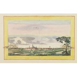
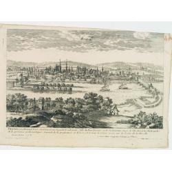
Hertzberg.
Very decorative and rare panoramic town view of Herzberg a.d. Schwarzen Elster, Bez. Cootbus.The engraver and publisher of prints, Mrs. Anna Beek of the Hague, enlarged t...
Place & Date: The Hague, ca. 1642
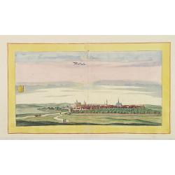
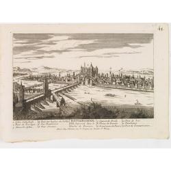
Weissensee.
Very decorative and rare panoramic town view of Weissensee in Thürigen, Bez. Erfurt.The engraver and publisher of prints, Mrs. Anna Beek of the Hague, enlarged the print...
Place & Date: The Hague, ca. 1642
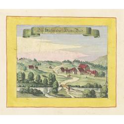
Das Wiesen oder Hiobs Badt.
Very decorative and rare panoramic town view of Wiensenbad near Annaberg im Erzgebirge.The engraver and publisher of prints, Mrs. Anna Beek of the Hague, enlarged the pri...
Place & Date: The Hague, ca. 1642
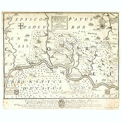
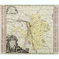
Nova Territorii Erfordien in suas praefecturas..
"Showing the area of Erfurt. In the lower part, there is a panoramic view of the town. Lower left and right splendid cartouches.The cartouches are painted in a stron...
- $300 / ≈ €281
Place & Date: Nurenberg, 1740
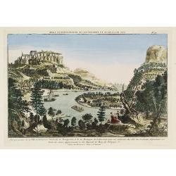
Vue perspective de la Ville et Forteresse Electorale de Koningstein, et de la Montagne de Lilienstein avec ses environs du côté du Couchant, dépendant des Etats de Saxe, appartenant à Sa Majesté le Roy de Pologne.
Perspective view of Königstein fortress, situated near to Dresden in Saxony. To the left the Fortress and in the foreground the river Elbe. The castle was inhabited by A...
Place & Date: Paris, 1760
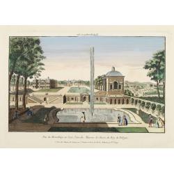
Vüe de Morestburg en Saxe, l'une des Maisons de Chasse du Roy de Pologne. (Castle Moritzburg)
So-called optical print illustrating a perspective view of the Castle Moritzburg, a Baroque Germanic castle in the small town of Moritzburg in the German state of Saxony....
- $250 / ≈ €234
Place & Date: Paris, 1760

A view of BILNITZ in Saxony one of the palaces of the King of Poland. / Vüe de Bilnitz, en Saxe, un des Palais du Roi de Pologne.
So-called optical print illustrating a perspective view of Pillnitz Castle, a restored Baroque castle at the eastern end of the city of Dresden. The castle was once the s...
- $300 / ≈ €281
Place & Date: Paris, 1760
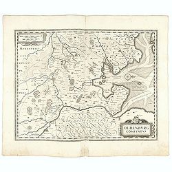
Oldenburg Comitatus
A map of the northern part of Germany centered on Oldenburg. Also showing Bremen. North to the right. The decoration consists with a windrose and a title cartouche surmou...
Place & Date: Amsterdam, 1629-1630
Carte générale d'Alemagne divisée par les cercles ou provinces d'icelle.
Rare and detailed map of Germany, Poland and Austria, engraved by H. le Roy in 1643 or 1666 for Jacques L'Agniet. The publishing house Jollain bought the copper plate and...
- $300 / ≈ €281
Place & Date: Paris, 1666
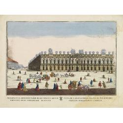
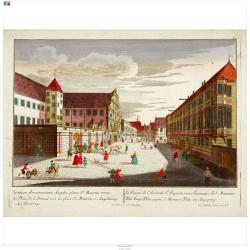
(Berlin) Prospectus Armamentarii regnii versus arcem principis regis haereditarii Berolini.
A square in Berlin. In the eighteenth and nineteenth centuries there were many popular speciality establishments in Paris, Augsburg and London which produced optical view...
- $200 / ≈ €187
Place & Date: Italy, 1770

Franconiae nova descriptio.
Second state of this early map of Franken, including Regensburg, Heidelberg, Marburg and Hof. In lower part decorative cartouches and upper right a dedication to Franz vo...
Place & Date: Amsterdam, after 1646

Hassia Landgraviatus.
Centered on the town of Kassel.
Place & Date: Amsterdam, 1650
Prussiae nova tabula.
Rare map of Prussia with nowadays Poland. The map features a bold title cartouche, a ship, compass rose, and a sea monster in the Baltic Sea. The map was prepared by the ...
- $550 / ≈ €515
Place & Date: Amsterdam, 1647
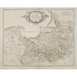
La Prusse divisée en Prusse Royale et Prusse Ducale. . .
Finely and crisply engraved map of Prussia including The Bay of Danzig. Folio map by Giles Didier Robert De Vaugondy.Ornamental title cartouche in the upper part of the m...
- $350 / ≈ €328
Place & Date: Paris, 1751
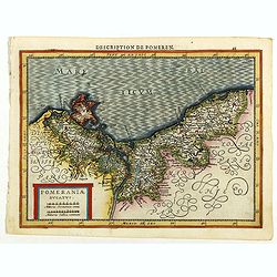
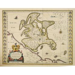
Pomeraniae Ducatus.
Pomerania map from the rare Cloppenburg edition slightly larger format and more scarce edition of the Mercator/Hondius "Atlas Minor". Small and detailed map of ...
Place & Date: Amsterdam, 1630
Principatus Isenacensis cum adjacentibus. . .
Detailed map centered on Gotha and Erfurt. Lower right splendid title cartouche.The map is painted in strong colors. Clearly from an show-piece atlas produced for a wealt...
- $200 / ≈ €187
Place & Date: Nurenberg, 1710

Carte De La Prusse Occidentale ou sont tracees les Provinces cedees Par la Pologne au Roi De Prusse . . . 1775
Finely and crisply engraved map of Western Prussia, now part of Poland on the Baltic Sea, including the Bay of Danzig. With ornamental title cartouche and noteworthy topo...
- $250 / ≈ €234
Place & Date: Venice, 1776 - 1784
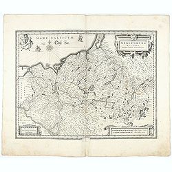
Nova totius Westphalia descriptio / ex celeberrimis et variis autoribus in unam tabulam redacta per Nicolaum Janssonium Visscher aut . . .
Shows the area between Maastricht, Dockum, Herschfelt and Hamburg. A fine copy in attractive original colors and dated in the plate, 1626.
- $200 / ≈ €187
Place & Date: Amsterdam, 1626
Der Zeug=Platz gegen S.Morizen Plaz zu Augspurg.
A well-known publisher of optical prints, established in Augsburg.In the eighteenth and nineteenth centuries there were many popular speciality establishments in Paris, A...
- $200 / ≈ €187
Place & Date: Augsburg, 1760
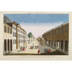
Vue de la Fontaine des Eaux chaudes et de la place d'Aix la Chapelle.
So-called optical print illustrating a perspective view of Aachen, in Nordrhein Westphalia, and namely the Elisa Fountain which contains two fountains with thermal water....
- $250 / ≈ €234
Place & Date: Paris, 1760
Typus Frisiae Orientalis.
Finely engraved map of east Frisia in Germany with the Watten islands. With inset map of the area south of Emden. Prepared by Ubbo Emmius (1547-1625). A very decorative t...
Place & Date: Amsterdam, 1635
La Prusse divisée en Prusse Royale et Prusse Ducale.
The map extends from Memem, Danzig and Rosienne in the North to Novigrod in the southeast and Thorn on the Wessel in the southwest. Shows the Gulf of Danzig and part of P...
- $300 / ≈ €281
Place & Date: Venice, 1776 - 1784
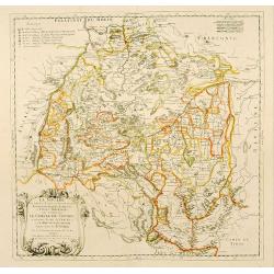
Meklenburg Ducatus.
Very detailed map of the northern part of Germany decorated with a coat of arms, a windrose and two saling ships.From the rare atlas Appendix, published in a very small n...
Place & Date: Amsterdam, 1629-1630
Ducatus Luneburgensis
Very detailed map centered on Albis river and the cities of Hamburg and Lunburg to the north. Also showing Bremen.
Place & Date: Amsterdam, 1629-1630
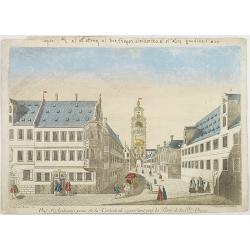
Breme.
A rare panoramic view of the city of Bremen, including a numbered legend in both lower corners.Published by the brothers Chéreau, active in Paris at rue st.Jacques au Gr...
- $200 / ≈ €187
Place & Date: Paris c.1720
Corbeiensis Dioecesis pro ut nunc est, descriptio noua Authore Joanne Gigante D. Medico et Mathemat.
Rare map of eastern part of Germany. West to the top. Showing the river Weser. Prepared by Johann Michael Gigas (1582-1637).
- $250 / ≈ €234
Place & Date: Venice, 1746
Rugia Insula ac ducatus. . .
Willem Blaeu's highly decorative map of the island of Rugen in the Baltic Sea from a map by Eihard Lubin. Embellished with a title-cartouches, and 30 coats-of-arms in the...
- $300 / ≈ €281
Place & Date: Amsterdam, 1638
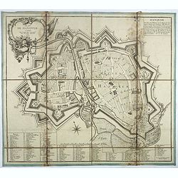
Plan de Hanover.
Town-plan of Hanover, with the new town of St Aegidien built in 1747. Decorated with a title cartouche and accompanied by a numbered key (1-79) of the main streets and bu...
- $200 / ≈ €187
Place & Date: Paris, 1757
![Mayence Mentz en allemand .. [Metz]](/uploads/cache/13109-250x250.jpg)
Mayence Mentz en allemand .. [Metz]
A very RARE panoramic view of the city of Metz, including a numbered legend in the lower corners. The plate is numbered in red pencil in the upper right corner.Engraved b...
- $200 / ≈ €187
Place & Date: Paris 1690-1720

Franciae orientalis../ Monasteriensis et osnaburgensis..
From 'Theatrum Orbis Terrarum [Atlas of the Whole World]' published in Antwerp. French text on verso.The map of Frankenland is prepared by Sebastian Rotenhan (1478-1532) ...
Place & Date: Antwerp, c.1574

Nieuwe Kaart van de Westfaalse Kreits..
Isaac Tirion was born in Utrecht ca. 1705. He came to Amsterdam ca. 1725. Tirion published a number of important books, many of which are still in demand for their intere...
Place & Date: Amsterdam, 1745
Territorium Abbatiae Herefeldensis - 't Stift Hirszfeldt.
Detailed map centered on Hirschfelt. Title cartouche embellished with two cherubs.
- $250 / ≈ €234
Place & Date: Amsterdam, 1647
Le cercle de la Basse Saxe subdivisé en touts les estats et principautés qui le composant . . .
It is a very large map centered on the river Elbe and following the coastlines of the Baltic Sea up to the Polish border. The map is fully and richly engraved. Large and ...
- $200 / ≈ €187
Place & Date: Amsterdam, c.1705
Nuremberg.
A very RARE panoramic view of the city of Nuremberg. The plate is numbered in red pencil in the upper right corner.Engraved by Pierre Aveline (Paris, c.1656 - 23 May 1722...
- $200 / ≈ €187
Place & Date: Paris, 1690-1720
Ausbourg Ville Impériale d'Allemagne dans la Suabe.
A very RARE panoramic of the city of Augsburg. The plate is numbered in red pencil in the upper right corner.Engraved by Pierre Aveline (Paris, c.1656 - 23 May 1722). He ...
- $250 / ≈ €234
Place & Date: Paris, 1690-1720
Treves en Allemend Trier.
A very RARE panoramic view of the city of Trier. The plate is numbered in red pencil in the upper right corner.Engraved by Pierre Aveline (Paris, c.1656 - 23 May 1722). H...
- $200 / ≈ €187
Place & Date: Paris, 1690-1720
Ratisbonne.
A very RARE panoramic town view of the city of Ratisbonne, including a numbered legend in both lower corners. The plate is numbered in black pencil in the upper right cor...
- $200 / ≈ €187
Place & Date: Paris c.1720
La Prusse divisée en Prusse royale, et Prusse Ducale. . .
Finely and crisply engraved map of Prussia including The Bay of Danzig. Ornamental title cartouche in the upper part of the map from his "Atlas Universel".Gille...
- $300 / ≈ €281
Place & Date: Paris, 1750
Le cercle de la haute saxe ou sont compris le duche et electorat de Saxe. . .
Fine map of Saxe with a decorative title and scale cartouche.Alexis-Hubert Jaillot (1632-1712), was a French cartographer. He joined the Sanson heirs and redrew Nicolas S...
- $250 / ≈ €234
Place & Date: Amsterdam, 1692
Ducatus Holsatiae nova tabula.
Finely engraved map centered on the area north of Hamburg and Lubeck with two insets. This is a second state of a map initially made by Jodocus Hondius.
- $250 / ≈ €234
Place & Date: Amsterdam, 1635
![[Breisach] Profil de la ville de Brisac scituée sur le Rhin dans le Brisgau prise par l'armée du Roy commandée par Monseign.r le duc de Bourgogne le 6.e septembre 1703.](/uploads/cache/43496-250x250.jpg)
[Breisach] Profil de la ville de Brisac scituée sur le Rhin dans le Brisgau prise par l'armée du Roy commandée par Monseign.r le duc de Bourgogne le 6.e septembre 1703.
Scene of the siege of Breisach in 1703 by Marshal Tallard during the Spanish Succession War.
- $200 / ≈ €187
Place & Date: Paris, 1703
Provincia ecclesiastica di Colonia nella Prussia (Tav LXXXI)
This large-format south Germany Cologne map is finely engraved and beautifully colored and was prepared by Girolamo Petri, a lawyer who served as a senior official within...
- $250 / ≈ €234
Place & Date: Rome, 1858
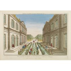
Vue perspective de l'Entrée du Parc du Prince de Manheim en Allemagne.
Perspective view of the Royal Park in Manheim by Basset, a well-known publisher of optical prints, established in rue St.Jacques in Paris. With brief key list.In the eigh...
- $200 / ≈ €187
Place & Date: Paris, 1760
Westphaliae Totius, Finitimarumque Regionum Accurata Descriptio.
A very beautiful hand colored copper engraved map of North Rhein-Westphalia by A. Ortelius. This is a general map of Westphalia and the surrounding regions in northwest G...
Place & Date: Antwerp, ca 1584
Philisbourg.
A very RARE panoramic view of the city of Philipsburg, including a numbered legend in both lower corners. The plate is numbered in black pencil in the upper right corner....
- $150 / ≈ €140
Place & Date: Paris c.1720
L'Allemagne dressée sur les observations. . .
Map of Germany, Low Countries, Poland, Switzerland, Northern Italy. Prepared by G.De L'Isle after observations by Kepler and Tycho Brahe.Engraved by Jean Batiste Liébaux...
- $300 / ≈ €281
Place & Date: Paris, 1788
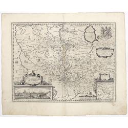
Praefectura Lipsiencis. . .
Detailed map centered around Leipzig with large pictorial cartouche and smaller cartouche of explanations. Alphabetical list of place names down both sides.
- $150 / ≈ €140
Place & Date: Augsburg, 1730
Osnabrugensis episcopatus.
A beautiful map of Munster centered on the city of Osnabruck. Prepared by Joannes Michael Gigas (1580-1650+), a doctor, mathematician and geographer. Showing an inset wit...
Place & Date: Amsterdam, 1638
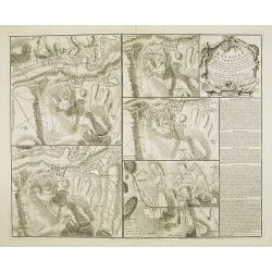
Bataille du Johansberg Gagnée par son Altesse Sérénissime Monseigneur le Prince de Condé . . . Le 30 Aoust 1762 . . .
Five detailed military battle-plans showing the four stages in the siege of Johansburg and the battle plan around Grüningen published by Jean de Beaurain (1696–1771) ....
- $150 / ≈ €140
Place & Date: Paris, 1766

La Saxe Contenant le Routes et les postes. . .
Fine post-route map of Saxony in Germany with a splendidly engraved title cartouche. The map is centered on Leipzig. George Louis Le Rouge was active between 1740 and 178...
Place & Date: Paris, 1756
La Prusse divisée en Prusse Royale et Prusse Ducale.
The map extends from Memem, Danzig and Rosienne in the North to Novigrod in the southeast and Thorn on the Wessel in the southwest. Shows the Gulf of Danzig and part of P...
- $200 / ≈ €187
Place & Date: Venice, 1776 - 1784

Vue de la ville et du château de Heidelberg . . . Ansicht der stadt und des schlosses Heidelberger . . .
Engraving after Louis Charles François de Graimberg-Belleau. Engraved by Ch. Haldennvang.French artist. Son of Gilles-François Belleau Graimberg. Louis Charles Françoi...
Place & Date: Graimberg, Heidelberg, ca. 1840

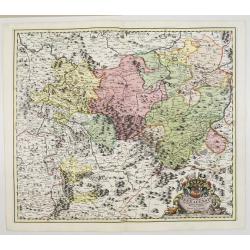
Dynastiae Comitat. Schoenburgici Penig, Remissa, Rochsburg, Wechselburg In Clientela Elect: Saxon Glaucha, Hartenstein, Lichtenststein, Walkenburg. . .
A very uncommon and superbly decorative map of Lower Saxony, the region southwest of Dresden. Including the towns of Rochlitz, Geringswalde, Mittweida, Frankenberg, Chemn...
Place & Date: Augsburg, 1750
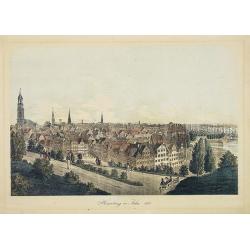
Hamburg im Jahre 1813
Decorative lithographed view of Hamburg. The print is issued in colors but finished by hand.
- $150 / ≈ €140
Place & Date: Germany,1820
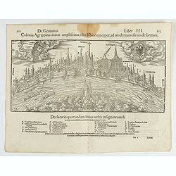
Colonia Agrippina civitas…
A wood block printed early panoramic view of Cologne (Germany). A lettered key A-Z beneath the view. The 1552 Latin text edition of Münster's Cosmographia is a short and...
- $70 / ≈ €66
Place & Date: Basel, 1552
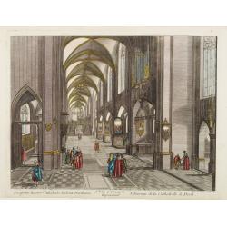
13e. Vüe d'Optique Representant L'Interieur de la Cathedralle de Dorth.
Optical view representing the interior of a Cathedral in Dörth, near Wiesbaden. Published by Daumont, a well-known publisher of optical prints, established in Paris.In t...
- $200 / ≈ €187
Place & Date: Paris, 1760
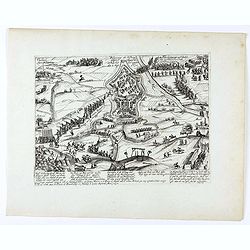
Belegerung der Vestung Gullich angefangen den 28. Julij, hat sich gegeben den 2. Sept. 1610.
Bird's eye-view of the siege of Jülich of 1610 which took place from 28 July to 2 September 1610, during the opening stages of the War of the Jülich Succession. After a...
- $150 / ≈ €140
Place & Date: Cologne, 1620
Osnabrugensis episcopatus. . .
A beautiful map of Munster centered on the city of Osnabruck. Prepared by Joannes Michael Gigas (1580-1650+), a doctor, mathematician and geographer. Showing an inset wit...
- $200 / ≈ €187
Place & Date: Amsterdam, 1629-1630
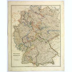
Western Germany.
A lovely, large steel engraved map of Western Germany. Some of the states engraved are: Holstein, Hannover, Mecklenburg, Saxony, Bavaria, Württemberg and Nassau. An extr...
Place & Date: London, 1839
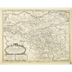
Le Comte de la Marck. . .
Fine map of the comte de la Marck with a decorative title and scale cartouche.Alexis-Hubert Jaillot (1632-1712), was a French cartographer. He joined the Sanson heirs and...
- $300 / ≈ €281
Place & Date: Amsterdam, 1692
![[Text page with imaginary towns in Westphalia and Hesse. CCLXXXIIII ].](/uploads/cache/37487-250x250.jpg)
[Text page with imaginary towns in Westphalia and Hesse. CCLXXXIIII ].
On recto, an imaginary view of towns in Westphalia (230x225mm.). Verso of towns in the province Hesse.Page from the richest illustrated Incunabula, the famous: Nuremberg ...
- $200 / ≈ €187
Place & Date: Nuremberg, 12 July 1493
Ansicht der Heidelberger Schlosses. . .
Early lithograph published by Louis Charles François de Graimberg-Belleau. Lithographed by C.F Müller.French artist. Son of Gilles-François Belleau Graimberg. Louis Ch...
Place & Date: Graimberg, Heidelberg, ca. 1840
Vue d'Ausbourg prise de la Cathedrale regardant vers la Porte de la Sainte Vierge.
Charming view of the Cathedral (Dom St. Maria) in Augsburg. In top of the print the title, in mirror image, in manuscript. Published by André Basset, the younger engrave...
- $100 / ≈ €94
Place & Date: Paris, ca 1760
Le marquisat et electorat de Brandebourg
Fine map of Brandenburg with a decorative title and scale cartouche.Alexis-Hubert Jaillot (1632-1712), was a French cartographer. He joined the Sanson heirs and redrew Ni...
- $100 / ≈ €94
Place & Date: Amsterdam, 1692
Carte generale de L'Empire d'Allemagne et pays circonvoisins. . .
Fine map of Germany, Low countries, Switzerland, Austria and Poland. The map was first published by Tavernier and later by Mariette. This edition carries the date 1642 an...
- $200 / ≈ €187
Place & Date: Paris, 1642/45-1657
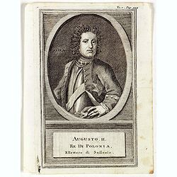
Augusti. II. Re di Polonia, Ellettore di Sassonia.
Portrait of Augustus II the Strong (12 May 1670 – 1 February 1733) of the Albertine line of the House of Wettin was Elector of Saxony (as Frederick Augustus I), Imperia...
Place & Date: Venice, 1739
Holsatia ducatus.
Map of Holsatia. Including the town of Hamburg.Mercator was born in Rupelmonde in Flanders and studied in Louvain under Gemma Frisius, Dutch writer, astronomer and mathem...
- $150 / ≈ €140
Place & Date: Amsterdam, 1606
Nova et Accurata Ducatus Cliviae et Comitatus Marchiae.
With an elaborate -uncolored- title cartouche.
Place & Date: Augsburg, 1728
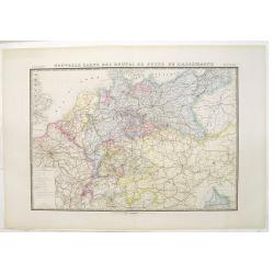
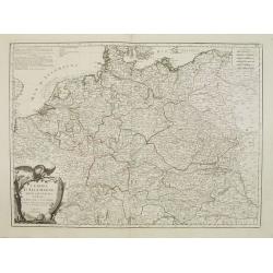
Nouvelle carte des routes de poste de l'Allemagne.
Large post road maps map of Germany, Poland, Austria, Franc, Switzerland, Austria and the Low Countries published by A. Logerot and engraved by C.Dyonnet.The mapsmakes di...
- $350 / ≈ €328
Place & Date: Paris, A. Logerot, c.1867
Circulus Saxoniae inferioris.
Detailed map of Saxen, including Bremen, Berlin, Lübeck, etc. Johann Baptist Homann (1663-1724) was a German engraver and publisher, who established himself and his fami...
- $200 / ≈ €187
Place & Date: Nuremberg 1740
La Souabe.
Fine map of Swabia.This edition carries the date 1674 and the publishers address A PARIS chez l'Autheur aux Galleries du Louvre. Nicolas Sanson was to bring about the ris...
- $75 / ≈ €70
Place & Date: Paris, 1674
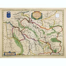
Clivia Ducatus et Ravestein Dominium.
A very decorative map with broad margins, showing a.o. the towns of Nijmegen, Venlo, Moers and Emmerich.
- $100 / ≈ €94
Place & Date: Amsterdam, 1647
L'Empire d'Allemagne..
Detailed map encompassing Germany, the Netherlands, Belgium, Austria, and part of Poland.Venetian edition of the map by Bellin, to whom Santini gives credit in the cartou...
- $100 / ≈ €94
Place & Date: Venice, 1776 - 1784
Westfaliae.
A nice map showing the province of Westphalia.Mercator was born in Rupelmonde in Flanders and studied in Louvain under Gemma Frisius, Dutch writer, astronomer and mathema...
- $100 / ≈ €94
Place & Date: Amsterdam, 1630