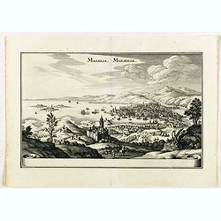
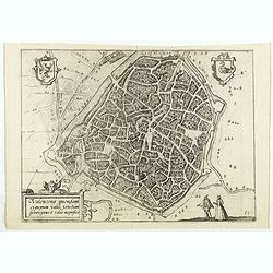
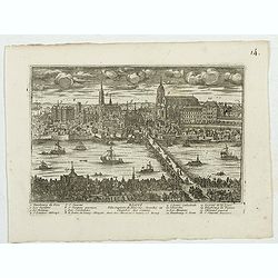
Massilia - Marseille.
Detailed bird's-eye view of the town of Marseille. From Merian's Theatrum Europaeum. To the bottom a lettered key to the principal places in town.
Place & Date: Frankfurt 1650
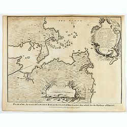
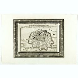
Plan of the Attack of Camaret Bay, on the coast of Bretagne, thro which lies the Harbour of Brest.
An interesting copper engraved plan of the Fortification of Camaret in Bretagne (France), with an attractive rococo cartouche, showing an overview of the battlefield and ...
Place & Date: London, 1743
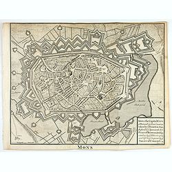
Mons the Capital City of Hainault in y Low Countries, taken by y French in 1691, Restor'd to y Spaniards by y Peace of Ryswick in 1697, retaken by y Allies in 1709, and left to y Emperor by y Treaty of Utrecht. .
An interesting copper engraved view of the walled city engraved by I. Basire, with pictographs of buildings. Many buildings and places are named on the map. Nicholas Tind...
Place & Date: London, 1743

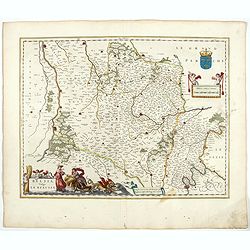
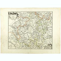
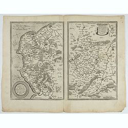
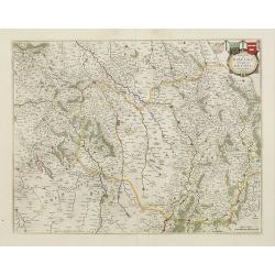
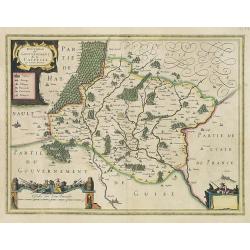
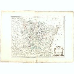
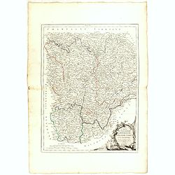
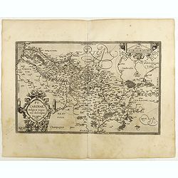
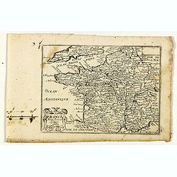
Regionis Biturigum... Per Ioannem Calamaeum. / Limaniae Topographia Gabriele Symeoneo Auct.
Two maps on one sheet. Biturigum. The Loire river is at the right in central France. Neuers (Nevers) is at the middle of the right margin. Bourges is near the center, an...
- $125 / ≈ €117
Place & Date: Antwerp, ca. 1598
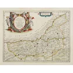
Belsia vulgo La Beausse.
In the left-hand lower part of the image a beautiful contemporary cartouche with goddess Ceres [agricultural] holding a reaping-hook in her right hand and receiving with ...
- $200 / ≈ €187
Place & Date: Amsterdam , 1644

Carte particuliere d'une grande partie des estats situez sur le haut rhein et sur les rivieres qui si déchargent comme sont L'Alsace, la Souabe et la Lorraine,&c. . .
Detailed map of Alsace, Lorraine and Souabe, centered on the River Rhine.
Place & Date: Paris, 1705
Champaigne et Brie etc.
A good engraved map of Champagne-Ardenne area, embellished with decorative title cartouche and scale cartouche with putti and surveying instruments. Paris, Metz, Reims, a...
- $150 / ≈ €140
Place & Date: Paris, ca. 1660
Projet de la forteresse de Nice.
Nice city plan of Nice at the Mediterranean sea. From the " Les forces de l'Europe, ou description des principales villes, avec leurs fortifications".
Place & Date: Leiden, 1729

Vue Perspective de la Place des Victoires
So-called optical print of la Place des Victoires in Paris. Therefore the image is reversed or mirror-image. One of the well-known publishers of optical prints, establish...
- $100 / ≈ €94
Place & Date: Paris, 1780
![Le Roy de Navarra venant à Paris recheut le coup de cousteau au visaige par ung Pierre Chastel, lequel par quatre chevaulx fut tiré en pièces, faict le 27 de Decemb[re] l'an 1594.](/uploads/cache/38548-250x250.jpg)
Le Roy de Navarra venant à Paris recheut le coup de cousteau au visaige par ung Pierre Chastel, lequel par quatre chevaulx fut tiré en pièces, faict le 27 de Decemb[re] l'an 1594.
Engraved news-sheet with text in German and French. Pictorial reportage on the failed assassination attempt on King Henri IV of France by Jean Châtel (here identified as...
Place & Date: Cologne, ca. 1600
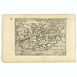
1) Caletensivm et Bononiensivm..2) Veromandvorvm eorvmque..
Prepared by Jean Surhon, cartographer, goldsmith and engraver. From 'Theatrum Orbis Terrarum [Atlas of the Whole World]': published in Antwerp.
- $200 / ≈ €187
Place & Date: Antwerp, 1580
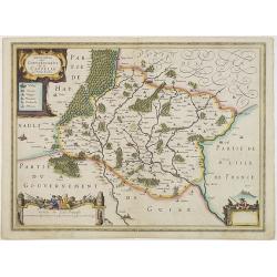
Description du Gouvernement de la CAPPELLE. Par P. Petit Bourbon.
Decorative map of Cappellein the region of the Nord-Pas-de-Calais in France with three decorative cartouches.The map of Cappelle is by Pierre Petit Bourbon (1598-1667), m...
- $100 / ≈ €94
Place & Date: Amsterdam, 1631
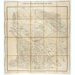
Carte des environs de Pau. . .
Folding map of Pau and its surroundings, being a reduced version of the map by Comte Dulong de Rosnay and engraved by Nicolas Delamare and published by Lafon.More about f...
- $90 / ≈ €84
Place & Date: Pau, Lafon, 1840-1850
Dicecese de Rheims, et le païs de Rethel. . .
Centered on Rheims. A very decorative map with beautiful cartouches of a province of France by one of the most famous map publishers.
- $300 / ≈ €281
Place & Date: Amsterdam, 1658
Dioecesis Sarlatensis, Vernacule.. Sarlat.
Detailed map of the region south of the Dordogne River, depicting Bergerac, Saint Cyprien, Montignac, Sarlat, Villefranche, etc.Embellished with an impressive title carto...
- $200 / ≈ €187
Place & Date: Amsterdam, 1658
Bitvrigvm, provinciae que Berry.
A rare and beautifully engraved map from the second edition of De Jode's atlas "Speculum Orbis Terrarum". Includes the Loire Valley, centered on Bourges and Vie...
- $200 / ≈ €187
Place & Date: Antwerp, 1593
Description du Gouvernement de la CAPPELLE. Par P. Petit Bourbon.
RARE without text on verso. Decorative map of Cappellein the region of the Nord-Pas-de-Calais in France with three decorative cartouches.The map of Cappelle is by Pierre ...
- $150 / ≈ €140
Place & Date: Amsterdam, 1631
![Cordelirs in Franckr. [France].](/uploads/cache/13799-250x250.jpg)
Cordelirs in Franckr. [France].
A very nice view of the town of Cordeliers. On the foreground, a man hunting a wolf is depicted. With a verse in German and Latin underneath the picture.The poet and topo...
- $80 / ≈ €75
Place & Date: Frankfurt, 1623-1678
Flandria Gallica Continens Castellanias Insulense . . .
No text on verso. Map of northern part of France, centered on Lille and part of Belgium.
Place & Date: Amsterdam, c. 1660
![Dépt. De L'Aude. N°10. [ Carcassonne ]](/uploads/cache/27089-250x250.jpg)
Dépt. De L'Aude. N°10. [ Carcassonne ]
Map of the Aude region, centered on the town of Carcassonne. Reaching to the right till the Mediterranean.Lovely map from one of the last decorative atlases of the ninete...
Place & Date: Paris, A. Combette, 1852
Karta öfver Frankrike.
An very rare map of France with Swedish text. This is an updated version of his map of 1819 and is now dated 1831.From his atlas "Geographisk Hand-Atlas" first ...
- $100 / ≈ €94
Place & Date: A. Wiborgs förlag, Stockholm, ca. 1848
Le Royaume de France..
Lovely small map of France with decorative title cartouche and a panel in the upper right corner listing local rulers.From Le Nouveau et Curieux Atlas Geographique et His...
- $75 / ≈ €70
Place & Date: Paris, 1719
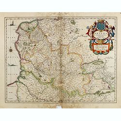
Artesia Comitatus. Artois.
Very decorative map of north-western part of France.As Willem Blaeu died in 1638 most of his maps are actually published by his son Joan. This maps carries his (engraved)...
- $80 / ≈ €75
Place & Date: Amsterdam, 1638
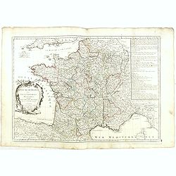
Le Royaume de France. . .
Decorative map of France with large title cartouche and a list of the "Provinces de France".Prepared by Le Sieur Janvier, Jean denis [Robert], a French geograph...
- $150 / ≈ €140
Place & Date: Venice, 1776 - 1784
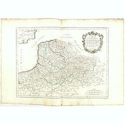
Gouvernements de Flandre Françoise, d'Artois, de Picardie. . .
Detailed map encompassing northwestern part of France, with the Channel and tip of southern England. With ornamental title cartouche and noteworthy topographical detail.T...
- $100 / ≈ €94
Place & Date: Venice, 1776 - 1784
Gouvernement de l'Isle de France et de celui de l'Orléanois. . .
Detailed map encompassing present day north of France.Venetian edition of the map by Bellin, to whom Santini gives credit in the cartouche.From "Atlas Universel"...
- $100 / ≈ €94
Place & Date: Venice, 1776 - 1784
Gouvernements de Lorraine et d'Alsace.
Detailed map encompassing present day the east of France.Venetian edition of the map by Bonne, to whom Santini gives credit in the cartouche.From "Atlas Universel&qu...
- $100 / ≈ €94
Place & Date: Venice, 1776 - 1784
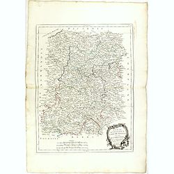
Gouvernements de Berri, du Nivernois,de la Marche, Limousin..
Detailed map encompassing Berri, Nivernois, Limousin and Auvergne.Venetian edition of the map by Bonne, to whom Santini gives credit in the cartouche.From "Atlas Uni...
- $75 / ≈ €70
Place & Date: Venice, 1776 - 1784
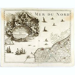
Carte des Pais Bas contenant la Flandre, le Brabant, Pais de Liege. . .
Map sheet from a multi-sheet map of the Low Countries, showing a large title cartouche and part of the Northern French coast line around Calais, Duinkerken and Furnes. Th...
- $75 / ≈ €70
Place & Date: Paris, 1742
![Carte generale de France. [de l'Europe]](/uploads/cache/38442-250x250.jpg)
Carte generale de France. [de l'Europe]
A fine and uncommon early 17th century map of France printed from two copper plates. Engraved by Liébaux.From the French text edition of "Description d'Univers"...
- $80 / ≈ €75
Place & Date: Paris, 1683
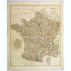
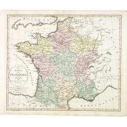
France.
A lovely, large steel engraved map of France, with an inset sketch of France divided into provinces, plus small inset map of the French Mediterranean island of Corsica . ...
Place & Date: London, 1839
Gouvernements de Bourgogne, de Franche Comté et de Lyonnois.
Detailed map encompassing Bourgogne, Franche Comté and Lyonnois.Venetian edition of the map by Bonne, to whom Santini gives credit in the cartouche.From "Atlas Univ...
- $100 / ≈ €94
Place & Date: Venice, 1776 - 1784
![[John Smith caught by the French.]](/uploads/cache/40473-250x250.jpg)
[John Smith caught by the French.]
In 1615, during one of John Smith’s voyages across the Atlantic, he was caught by some French pirates. While at sea in captivity he was forced to suffer great hardships...
- $75 / ≈ €70
Place & Date: Frankfurt, M.Merian, 1633
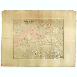
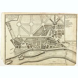
Quartier de Tivoli Nouveaux pereements de Rues.
Plan of the center of Paris showing Tivoli district with Madalene and Clichy. Lithography and pen and ink. Drawn in are the planned workshop of Serrurerie Théophile Mign...
Place & Date: Paris, ca.1835
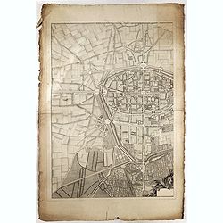
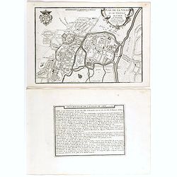
(Rheims)
Finely engraved plan of Rheims.
Place & Date: ca. 1750
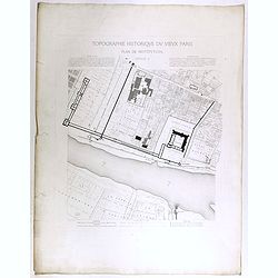
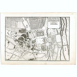
Topographie historique du vieux Paris / Plan de restitution Feuille V.
Copper engraved plan centered on Louvre by Jean-Joseph Sulpis (1826–1911) after a model by Adolphe Berty. Plate 5 from "Topographie historique du vieux Paris"...
Place & Date: Paris, 1866-1897
Picardiae Belgicae regionis descriptio
From Theatrum Orbis Terrarum [Atlas of the Whole World]. Prepared by Jean Surhon.Dare to go in Black. All early maps were printed in black and white, and many were kept t...
Place & Date: Antwerp, 1590
Les Provinces, ou Gouvernement de Poictou, d'Anjou, du Maine, De Touraine . . .
Map centered on Loire region, with Blois, Saumur, Sancerre and Orleans, from Nicolas de Fer's "L'Atlas curieux ou le Monde réprésente dans des cartes. "The &q...
Place & Date: Paris, 1705
Plan de la ville et du château de Caën en Normandie.
Plan of the city of Caen, from Nicolas de Fer's "L'Atlas curieux ou le Monde réprésente dans des cartes. "The "Atlas Curieux" is a geographic encycl...
Place & Date: Paris, 1705
Plan general des chateaux et ville de St Germain en Laye.
City plan of St Germain en Laye, from Nicolas de Fer's "L'Atlas curieux ou le Monde réprésente dans des cartes. "The "Atlas Curieux" is a geographic...
Place & Date: Paris, 1705
Plan de la belle et magnifique Maison de Monsieur A St Cloud . . .
Plan of the city of Saint Cloud, from Nicolas de Fer's "L'Atlas curieux ou le Monde réprésente dans des cartes. "The "Atlas Curieux" is a geographic...
Place & Date: Paris, 1705
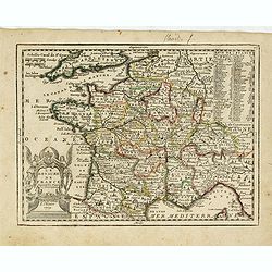
France nouvellement descripte.
Rare map of France, published by Jollain in 1667. Published in "Trésor Des Cartes Geographiques Des Principaux Estats de Lunivers".This atlas is based upon Boi...
- $150 / ≈ €140
Place & Date: Paris, 1667
Nouvelle Carte des Differents Etats de la Monarchie Françoise Sous Iule Cesar, Sous les Rois de la Premiere, de la Seconde . . .
Four maps of France surrounded by historical and genealogical information to the history, chronology, ancient and modern genealogy of the french monarchy.Henri Abraham Ch...
- $75 / ≈ €70
Place & Date: Amsterdam, 1720
![[Les anciennes provinces Françaises à la ville de Saint Denis].](/uploads/cache/41681-250x250.jpg)
[Les anciennes provinces Françaises à la ville de Saint Denis].
Nine small chromolithography's trade cards for Ville de Saint Denis, each with French regions and places, with description in French on each verso.Cards of the regions : ...
Place & Date: Paris, circa 1900
![[Les anciennes provinces Françaises à la ville de Saint Denis].](/uploads/cache/41683-250x250.jpg)
[Les anciennes provinces Françaises à la ville de Saint Denis].
Nine small chromolithography trade cards for Ville de Saint-Denis, each with French regions and places, with description in French on each verso.Cards of the regions: Lor...
Place & Date: Paris, circa 1900
![[Les anciennes provinces Françaises à la ville de Saint Denis].](/uploads/cache/41684-250x250.jpg)
[Les anciennes provinces Françaises à la ville de Saint Denis].
Nine small chromolithography's trade cards for Ville de Saint Denis, each with French regions and places, with description in French on each verso.Cards of the regions : ...
Place & Date: Paris, circa 1900
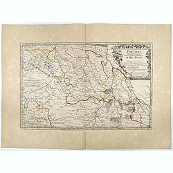
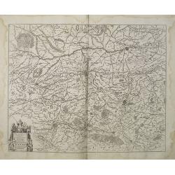
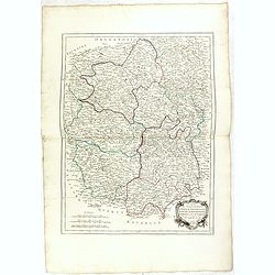
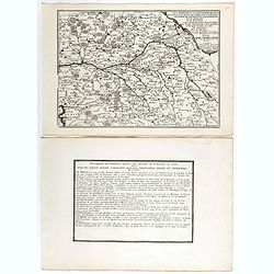
Partie Septentrionale de l'Evesché de Poictiers. Partie Septentrionale du Haut Poitou.
Rare map engraved by R. Michault and published "a Paris chez Greg. Mariette sur le quay de l'Horloge au dessus de la cour de Lamoignon". Dedicated to the Bishop...
- $125 / ≈ €117
Place & Date: Paris, 1690
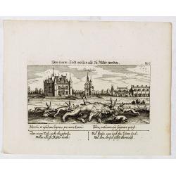
In einem Todt wollen alle zu Ritter werden.
A very nice view of a dead lion, surrounded by rabbits and in the background a French castle. With a verse in two languages underneath the picture. "In einem Todt, n...
- $70 / ≈ €66
Place & Date: Frankfurt, 1623-1678
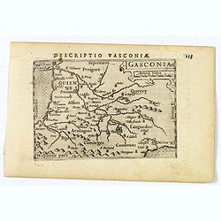
Gasconia.
A lovely miniature map of Gascony, in the S.W. region of France, published by Petrus Bertius, in Amsterdam at the beginning of the seventeenth century. There is a small s...
Place & Date: Amsterdam, 1606
![Descriptio Gadium [France].](/uploads/cache/43237-250x250.jpg)
Descriptio Gadium [France].
An attractive miniature map of France, published by Petrus Bertius, in Amsterdam at the beginning of the seventeenth century. Title in bold capital letters above map, sti...
Place & Date: Amsterdam, 1606

ÉGLISE St. VINCENT A ROUEN. Dessiné d'après nature par Chapuy. Lith. par Monthelier. Fig. par Bayot.
Original lithograph of St Vincent cathedral, situated in Rouen. Lithographed by Jules Monthelier (1801-1883) and Adolphe-Jean-Baptist Bayot (Alessandria 1810 - 1866) afte...
- $80 / ≈ €75
Place & Date: Paris, 1844

PORTAIL SEPTENTRIONAL DE LA CATHÉDRALE A CHARTRES. Dessiné d'après nature par Monthelier. Lith. par Monthelier.fig. par Bayot.
Original lithograph of the northern portal of Chartres cathedral. Lithographed by Jules Monthelier (1801-1883) and Adolphe-Jean-Baptist Bayot (Alessandria 1810 - 1866) af...
- $75 / ≈ €70
Place & Date: Paris, 1844
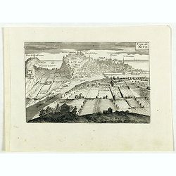
Veüe de Nice.
Engraved birds eye view of Nice. Shows rivers, canals, bridges, landmarks, farms and buildings. Relief shown pictorially.
Place & Date: Paris, 1692
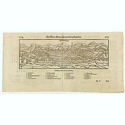
Die statt Montpellier . . .
Panoramic view of Montpellier by Sebastian Münster. Below the engraving a letterpress key. From the German edition of Sebastian Munster's Cosmography, "Cosmographey...
Place & Date: Basel, Heinrich Petri, 1574
Valencena . . .
Eye-bird view of Valenciennes.
Place & Date: Anvers, 1590
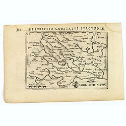
Descriptio Comitatus Burgundiae.
A decorative small map of region around Dijon, Halons and Dole in Burgundy. Features a nice strap-work title, shows rivers and settlements. From the Bertius atlas Tabular...
- $100 / ≈ €94
Place & Date: Amsterdam, 1606
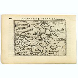
Descriptio Biturigum.
A charming small map of central France. Showing the areas around the rivers Loire, Auron, Allier and Yevre. Nevers and Bourges depicted. From the Bertius atlas Tabularum ...
- $100 / ≈ €94
Place & Date: Amsterdam, 1606
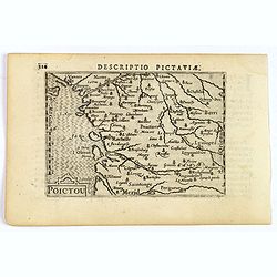
Descriptio Pictaviae.
A charming small map of Poitou in west central France. Showing Cognac, Limoges, Perigord, Poitiers and Angouleme. From the Bertius atlas Tabularum geographicarum contract...
- $100 / ≈ €94
Place & Date: Amsterdam, 1606
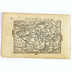
Descriptio Galliae.
A charming small map of ancient Gaul, France under Roman occupation. Featuring most major cities, rivers, mountains and regions are named. From the Bertius atlas Tabularu...
- $100 / ≈ €94
Place & Date: Amsterdam, 1606
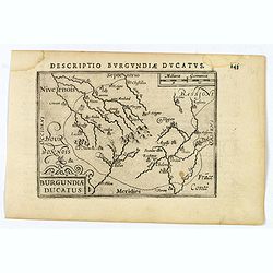
Descriptio Burgundiae Ducatus.
A decorative small map of region around Dijon, Chalons and Dole in Burgundy. Shows many rivers including the Seine, Saone and Brune. It features a nice strap-work title, ...
- $100 / ≈ €94
Place & Date: Amsterdam, 1606
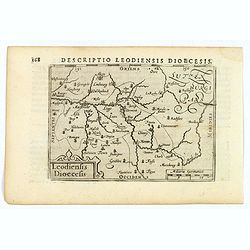
Descriptio Leodiensis Dioecesis.
A decorative map of the ancient Diocese of liege in Belgium, highlighting cities such as Huy, Liege, Tongeren (old capital), Namur and Maastricht. North is orientated to ...
- $100 / ≈ €94
Place & Date: Amsterdam, 1606
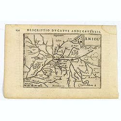
Aniou.
Anjou is a historical province of France, straddling the lower Loire River. Its capital was Angers. It bordered Brittany to the west, Maine to the north, Touraine to the ...
- $100 / ≈ €94
Place & Date: Amsterdam, 1606
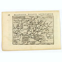
Lotharingia.
Lothringaria (Lorraine) is a historical province of N.E. France, it features the cities of Sarrebourg, Metz, Toul and Nancy. With excellent physical and topographical det...
- $100 / ≈ €94
Place & Date: Amsterdam, 1606
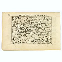
Limania.
A pleasant miniature map of the Limousin region of central France, the area surrounding Clermont Ferrand. Good map detail. From the Bertius atlas Tabularum geographicarum...
- $100 / ≈ €94
Place & Date: Amsterdam, 1606
![Venuxinus Comitatus. [Vaucluse]](/uploads/cache/43427-250x250.jpg)
Venuxinus Comitatus. [Vaucluse]
A pleasant miniature map of the Vaucluse region of S.E. France, as published by Petrus Bertius in Amsterdam at the beginning of the seventeenth century. Many mountains as...
- $100 / ≈ €94
Place & Date: Amsterdam, 1606
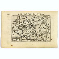
Savoie.
A decorative miniature map of Savoy - a cultural region in Central Europe that comprises roughly the territory of the Western Alps between Lake Geneva in the north and Da...
- $100 / ≈ €94
Place & Date: Amsterdam, 1606
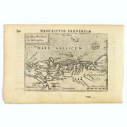
Descriptio Provinciae.
A decorative miniature map of Provence - a geographical region and historical province of south-eastern France, which extends from the left bank of the lower Rhône River...
- $100 / ≈ €94
Place & Date: Amsterdam, 1606
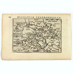
Descriptio Veromanduorum.
A decorative miniature map of Aisne (Vermandois), a French department in the Hauts-de-France region of northern France. It is named after the river Aisne. The map is cent...
- $100 / ≈ €94
Place & Date: Amsterdam, 1606
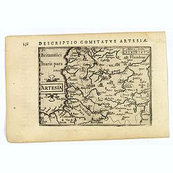
Artesia.
A decorative miniature map of Artois, a historical northern French province that borders Belgium. A map full of detail and is expertly engraved. With the cities of Boulo...
- $100 / ≈ €94
Place & Date: Amsterdam, 1606
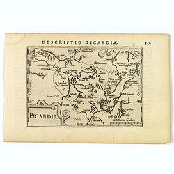
Picardia.
A decorative miniature map of Picardy, a historical northern French region. A map that appears to be sparsely populated is still full of detail with great attention to de...
- $100 / ≈ €94
Place & Date: Amsterdam, 1606
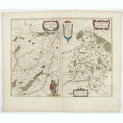
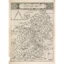
Veromanduorum.. Vermandois / Gouvernement de la Capelle.
A very decorative map with beautiful cartouches of a province of France by one of the most famous map publishers. Signed by Guilielmus Blaeu.From early on Willem Jansz. B...
- $150 / ≈ €140
Place & Date: Amsterdam, 1644
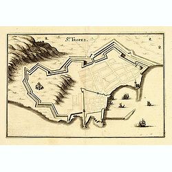
St Tropez.
Plan of St Tropez by M.Merian. Depicts a street layout and ships in harbour etc.
- $100 / ≈ €94
Place & Date: Frakfurt, 1660
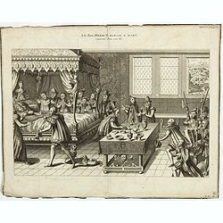
Le Roi Henri II blassé a mort representanté dans son lit.
Print showing King Henry II in his death bed. In June 1559 a tournament lasting several days was held in Paris to celebrate a peace treaty between France and Spain. King ...
- $100 / ≈ €94
Place & Date: Paris, 1729-1733
Caletensium et Bononiesium def.
An decorative miniature map of the N.W. France, including Calais and Boulogne. A map full of detail and attractive embelishments. North is orientated to the left. From th...
- $100 / ≈ €94
Place & Date: Amsterdam, 1606
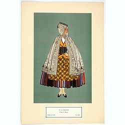
Femme de Barèges (106, La Gascogne).
Plate published in "Les costumes régionaux de France" with illustrations by Gratiane de Gardilanne (painter and designer) and Elisabeth Whitney Moffat.Costume ...
- $75 / ≈ €70
Place & Date: Paris, Editions du Pégase, 1929

Laitière Bordelaise, d'après de Gallard (110, La Guyenne).
Plate published in "Les costumes régionaux de France" with illustrations by Gratiane de Gardilanne (painter and designer) and Elisabeth Whitney Moffat.Costume ...
- $75 / ≈ €70
Place & Date: Paris, Editions du Pégase, 1929
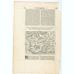
Page from La Cosmographie Universelle with map of France. (Page 160)
Text page with woodblock map of ancient France (122 x 163 mm.) In 1575 Sebastian Münster's Cosmographia was translated into French and published in Paris by François d...
- $75 / ≈ €70
Place & Date: Paris, 1575
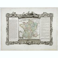
La France Divisée en ses quarante gouvernemens . . .
Map of France surrounded by a decorative frame.
Place & Date: Paris, 1770
Blois ville capitale du Blaisois, Eveshé et Chambre des Comptes.
Bird-eyes view of Blois, published in Paris by Chereau who was active at rue St Jacques à S Remy.
- $100 / ≈ €94
Place & Date: Paris, ca. 1710
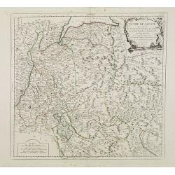
Duché de Savoye qui comprend..
Finely and crisply engraved map of Savoy. Venetian edition of de Vaugondy's map, from "Atlas Universel" printed in 1776-84.Large decorative title cartouche in t...
- $150 / ≈ €140
Place & Date: Venice, 1776 - 1784