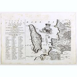
Browse Listings in Europe
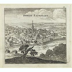
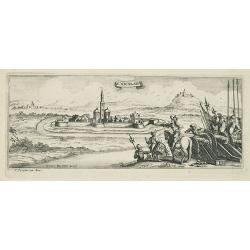
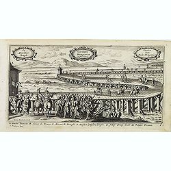
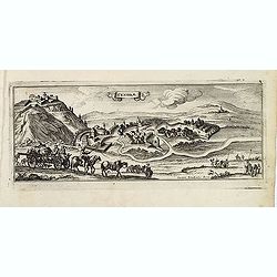
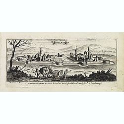
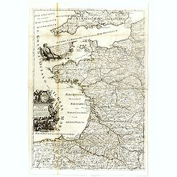
Donau Eschingen. / Der donaü stränd.
Two views pasted on recto and verso of a larger sheet of paper. On recto panoramic view of Donaueschingen a German town in the Black Forest.On verso a map of the Danube a...
- $75 / ≈ €64
Date: Nuremberg, Jacob Sandrart, 1684
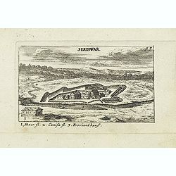
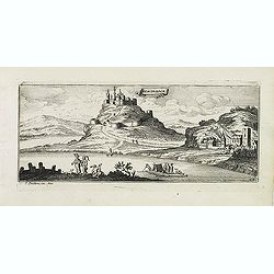
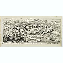
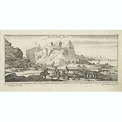
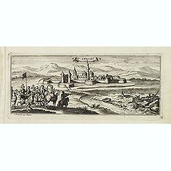
Serinwar. (Zrínyi vár)
Panoramic view of Zrínyi vár in Hungary. Published in "Der Donau-Strand Mit allen seinen Ein- und Zuflüssen. . .". Published by Jacob Sandrart.
- $90 / ≈ €76
Date: Nuremberg, Jacob Sandrart, 1684
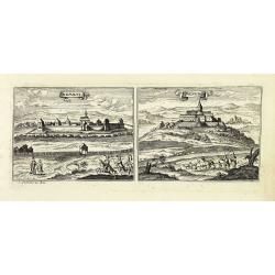
![Erla [Eger]](/uploads/cache/30834-250x250.jpg)
Erla [Eger]
Panoramic view of Eger. Published in "Der Donau-Strand Mit allen seinen Ein- und Zuflüssen. . .". Published by Jacob Sandrart.
- $150 / ≈ €127
Date: Nuremberg, Jacob Sandrart, 1684
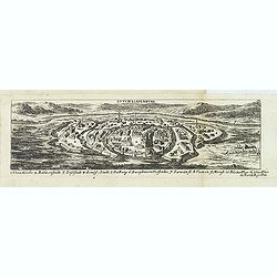
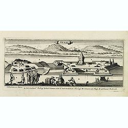
Stulweissenburg. (Székesfehérvár)
Panoramic view of Székesfehérvár. Published in "Der Donau-Strand Mit allen seinen Ein- und Zuflüssen. . .". Published by Jacob Sandrart.
- $100 / ≈ €85
Date: Nuremberg, Jacob Sandrart, 1684
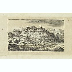
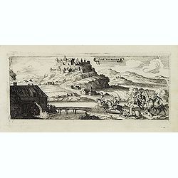
S. Martinsberg.
Panoramic view of S. Martinsberg. Published in "Der Donau-Strand Mit allen seinen Ein- und Zuflüssen. . .". Published by Jacob Sandrart.
- $100 / ≈ €85
Date: Nuremberg, Jacob Sandrart, 1684
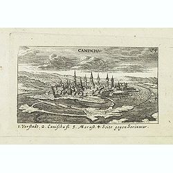
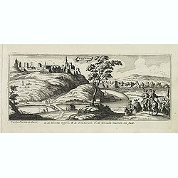
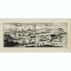
Canischa. (Nagykanizsa / Kanizsa)
Panoramic view of Nagykanizsa / Kanizsa. Published in "Der Donau-Strand Mit allen seinen Ein- und Zuflüssen. . .". Published by Jacob Sandrart.
Date: Nuremberg, Jacob Sandrart, 1684
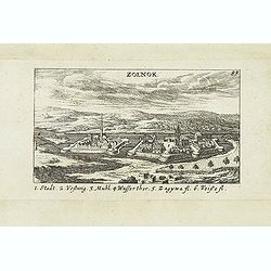
Zolnok.
Panoramic view of Szolnok (solnok) is the county seat of Jász-Nagykun-Szolnok county in central Hungary. Its location on the banks of the Tisza river, at the heart of th...
- $75 / ≈ €64
Date: Nuremberg, Jacob Sandrart, 1684
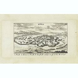
Gyula.
Panoramic view of Gyula in Békés County, Hungary. The town is best known for its Medieval castle and thermal bath. Published in "Der Donau-Strand Mit allen seinen ...
- $75 / ≈ €64
Date: Nuremberg, Jacob Sandrart, 1684
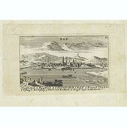
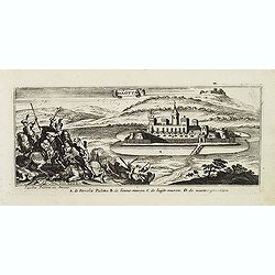
Rab. / Leopoldina. / Der Grosse und wunderbare Comet. . .
On recto panoramic view of Raab or Gyor, the Hungarian town on the Danube. On verso a plan of Leopoldina and a view of comet. Published in "Der Donau-Strand Mit alle...
- $90 / ≈ €76
Date: Nuremberg, Jacob Sandrart, 1684
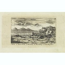
Dotis.
Panoramic view of Dotis (Tata). Published in "Der Donau-Strand Mit allen seinen Ein- und Zuflüssen. . .". Published by Jacob Sandrart.
- $150 / ≈ €127
Date: Nuremberg, Jacob Sandrart, 1684
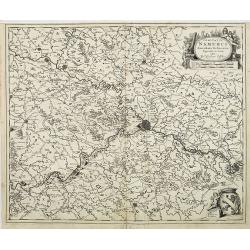
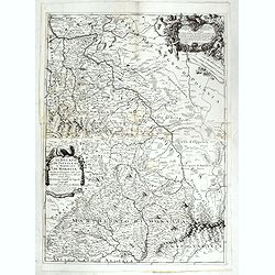
Comitatus Namurci Emendata Delineatio, Nuperrimè in lucem edita, per Nicolaum Visscher.
Detailed engraved map of the province of Namur (Namen), showing cities including Charleroi and Dinant., towns, rivers and lakes. Decorative cartouche with putti. Explanat...
Date: Amsterdam, 1684
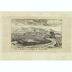
Papa.
Panoramic view of historical city Papa. Published in "Der Donau-Strand Mit allen seinen Ein- und Zuflüssen. . .". Published by Jacob Sandrart.
- $100 / ≈ €85
Date: Nuremberg, Jacob Sandrart, 1684
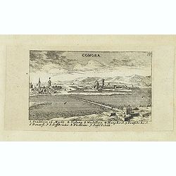
Comora.
Panoramic view of Comora. Published in "Der Donau-Strand Mit allen seinen Ein- und Zuflüssen. . .". Published by Jacob Sandrart.
- $100 / ≈ €85
Date: Nuremberg, Jacob Sandrart, 1684
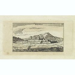
Palota.
Panoramic view of Palota in the Medzilaborce District in the Prešov Region of far north-eastern Slovakia. Published in "Der Donau-Strand Mit allen seinen Ein- und Z...
- $150 / ≈ €127
Date: Nuremberg, Jacob Sandrart, 1684
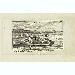
Sissek.
Panoramic view of Sisak in Sisak in central Croatia. Published in "Der Donau-Strand Mit allen seinen Ein- und Zuflüssen. . .". Published by Jacob Sandrart.
- $75 / ≈ €64
Date: Nuremberg, Jacob Sandrart, 1684
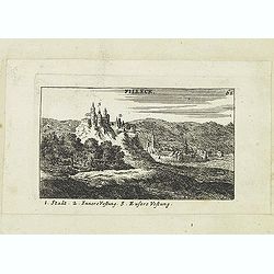
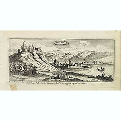
Filleck.
Panoramic view of Filleck (Fuleck, Filakovo). Published in "Der Donau-Strand Mit allen seinen Ein- und Zuflüssen. . .". Published by Jacob Sandrart.
- $150 / ≈ €127
Date: Nuremberg, Jacob Sandrart, 1684
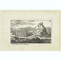
Novigrad.
Panoramic view of Nógrád in northern Hungary. Published in "Der Donau-Strand Mit allen seinen Ein- und Zuflüssen. . .". Published by Jacob Sandrart.
- $150 / ≈ €127
Date: Nuremberg, Jacob Sandrart, 1684
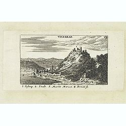
Vicegrad.
Panoramic view of Vicegrad. Published in "Der Donau-Strand Mit allen seinen Ein- und Zuflüssen. . .". Published by Jacob Sandrart.
- $100 / ≈ €85
Date: Nuremberg, Jacob Sandrart, 1684
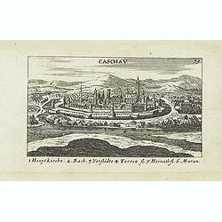
Caschav.
Panoramic view of Caschav (Cassovie). Published in "Der Donau-Strand Mit allen seinen Ein- und Zuflüssen. . .". Published by Jacob Sandrart.
- $100 / ≈ €85
Date: Nuremberg, Jacob Sandrart, 1684

Het Hooge Heemraedtschap van Schielandt.
This beautiful wall map of "Het Hooge Heemraedtschap van Schielandt" is on nine attached leaves (each leaf 49x58,5 cm. ) engraved by J. VINGBOOMS after J.J. STA...
Date: Rotterdam, A. van Hoorn, 1684

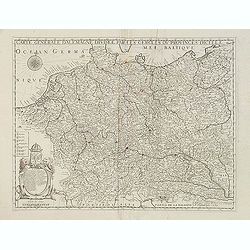
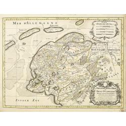
Le Cours de l'Elbe et de l'Oder où sont les Electorats de Saxe et de Brandebourg, les Duchés de Mekelbourg et de Pomeranie. . .
A detailed and scarce map showing the rivers Elbe and Oder in Germany and Poland. Dark engraving.This is one sheet of the four sheet wall map by Pierre Du Val entitled: &...
Date: Paris, 1684
S. Nicolaes.
Beautifully etched by Gasper Bouttats (1640-1695) of Szent-Nicolas (Madarsko). Published by Jacques Peeters.
- $150 / ≈ €127
Date: Antwerp, c. 1684
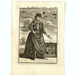
GM de Malte. Der Grossmeister von Malta Fig. XVIII.
Charming late 17th century engraving of grand master of Malta.By Allain Manneson Mallet (1630-1706), a well traveled military engineer and geographer who worked in 17th c...
- $120 / ≈ €102
Date: Frankfurt, 1685
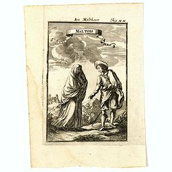
Maltois. Ein Maltheser Fig. XX.
Charming late 17th century engraving of a couple in local dress from Malta.By Allain Manneson Mallet (1630-1706), a well traveled military engineer and geographer who wor...
- $120 / ≈ €102
Date: Frankfurt, 1685
Zemblien.
Engraving presenting inhabitants of Nova Zembla from his monumental work "Description de L'Univers."
Date: Paris, 1685
![Ancien Cheva.er de Malte Ein Alter Malthese Ritter Fig: XVI [Together with] D. Gregoire Caraffe G.M. de Malte MDCLXXXI.](/uploads/cache/35860-250x250.jpg)
Ancien Cheva.er de Malte Ein Alter Malthese Ritter Fig: XVI [Together with] D. Gregoire Caraffe G.M. de Malte MDCLXXXI.
Two charming late 17th century engravings of an Knight of Malta and an round portrait of Gregoire Carafa.The copper plate seems during the printing process not well clean...
- $120 / ≈ €102
Date: Frankfurt, 1685
Malte Die Stadt Malta Fig: XV.
A charming late 17th century birds-eye view of Valletta and its fortifications from the southeast with battle ships in the sea. Title scroll in the sky.The copper plate s...
- $250 / ≈ €212
Date: Franckfurt, 1685
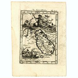
Isle de Malthe. Die Insul Maltha Fig: XIV.
A charming late 17th century map of Malta and Gozo with a large pictorial cartouche depicting Neptune and a merman, a nautical sailing ship scene across the bottom.The co...
- $250 / ≈ €212
Date: Frankfurt, 1685
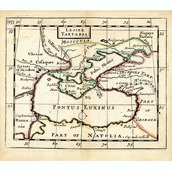
Lesser Tartaria.
A late seventeenth-century English map of the Crimea and southern Ukraine, with the whole of the Black Sea and its shores. A scarce little map utilized in various of the ...
- $300 / ≈ €255
Date: London, 1685
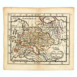
Moscovia or Russia
A rare late seventeenth-century English map of Russia and the Crimea and southern Ukraine, with the northern coast of the Black Sea and its shores. A scarce little map ut...
- $300 / ≈ €255
Date: London, 1685
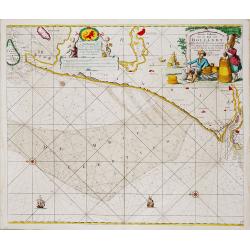
Nieuwe Paskaert van de Kust van HOLLANDT - Tussen Texel en de Maes.
Nieuwe Paskaert van de Kust van Hollandt Tussen Texel en de Maes. A very attractive sea chart off the coast of Holland by Johannes van Keulen with a pair of decorative c...
- $500 / ≈ €425
Date: Amsterdam, ca 1685
Moscovie dite autrement Grande et Blanche Russie.
Uncommon map of the Russia, including Finland, here with the date 1686.
Date: Paris, 1686

Les Provinces des Pays Bas.
RARE. From his first edition of his only folio atlas, the map is relied upon the map of his uncle, Nicolas Sanson. Engraved by I.Somer.A nice map of Netherlands.
Date: Paris 1687

Carte du Palatinat du Rhin.
Decorative "carte à figures"- map centered on Koblenz, Metz, Strasburg, Manheim and Heidelberg, with the river Rhine by François Jollain (ca. 1641 – 18 Apri...
Date: Paris, ca. 1688
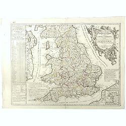
Le Royaume d'Angleterre.
An attractive map centered on England, Wales and the southern part of Scotland. The very decorative cartouche includes a dedication to Jacques II Roy d'Angleterre, d'Esco...
- $650 / ≈ €552
Date: Paris, 1689
La Prussia Divisa in Reale Che Appartiene al Ré Di Polonia et in Ducale Che Spetta all'Elettore Di Brandeburgo. Da Giacomo Cantelli Da ...
In the upper left-hand corner a large title cartouche with a dedication to Cardinal Denhoff. The map is dated 1689.The cartographer was Giacomo Cantelli (1643-1695) who w...
- $1000 / ≈ €850
Date: Rome, 1689
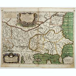
La Bulgaria ela Romania con Parte di Marcedonia. . .
Scarce map of the region along the Danube River and to the south. Extends to include part of the Sea of Azov and the northern extreme of the Aegean Sea. Elaborate militar...
- $600 / ≈ €510
Date: Rome, 1689
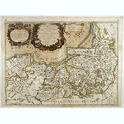
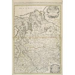
Carte générale d'Alemagne divisée par les cercles ou provinces d'icelle.
Rare and detailed map of Germany, Poland and Austria, engraved by H. le Roy in 1643 or 1666 for Jacques L'Agniet. Published by François Jollain (ca. 1641 – 18 April 17...
- $450 / ≈ €382
Date: Paris, 1689
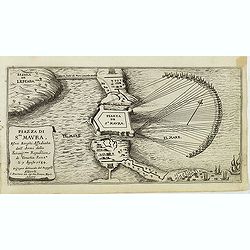
Piazza di Sta Maura esvoi Borghi Affediata dall Armi della. . .
Magnificent bird's eye- with the northern tip of the island of Santa Maura (today Lefkada). Situated very close to the mainland to which it is linked by a long strip of s...
Date: Antwerp, c.1690
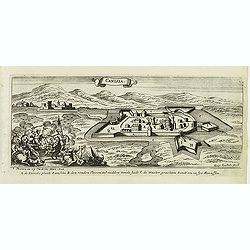
Canisia.
Magnificent bird's eye- of Nagykanizas. Etched by Gaspar Bouttats (1640-1695).The Antwerp based publisher Jacques Peeters published ca. 1690 a series of prints related to...
- $90 / ≈ €76
Date: Antwerp, c.1690
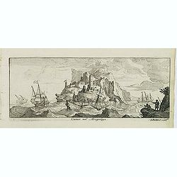
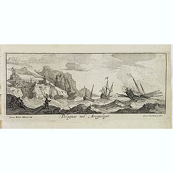
Canistro nel Arcipelago.
Magnificent view of Kanaestreo and its harbour front, decorated with ships and rowing boats in a rough sea. Engraved by Lucas Vostermans II, who was born in 1624, in the ...
- $100 / ≈ €85
Date: Antwerp, c.1690
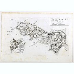
Isola del Re Nel Mare di Guascogna . . .
A beautiful map showing Ile de Ré in Bretagne, located in the Bay of Biscay off the coast of France, from Vincenzo Coronelli's Corso Geografico Universale.Italian text o...
Date: Venice, 1690
Isola d'Oleron, nella piaggie occidentali della Francia.
A beautiful and rare map showing île d'Oleron.The remarkable Vincenzo Coronelli (1650-1718), encyclopaedist, geographer, inventor and Doctor of Theology, was citizen of ...
Date: Venice, 1690
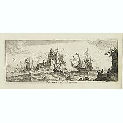
Bartanico nel Arcipelago. (Bartanico)
Magnificent shipping scene offshore of Bartanico. Engraved by Lucas Vostermans II, who was born in 1624, in the same year when the family moved to England for six years. ...
- $125 / ≈ €106
Date: Antwerp, c.1690
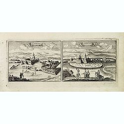
Nembti / Sengrot.
Magnificent bird's eye-town-views of Lenti and Zalaszengrot. Etched by Gaspar Bouttats (1640-1695).The Antwerp based publisher Jacques Peeters published ca. 1690 a series...
- $80 / ≈ €68
Date: Antwerp, c.1690
St Martinsbergh.
Magnificent bird's eye- of Pannonhalma (Szentmártonhegy). Etched by Gaspar Bouttats (1640-1695).The Antwerp based publisher Jacques Peeters published ca. 1690 a series o...
- $75 / ≈ €64
Date: Antwerp, c.1690
Schombock.
Magnificent bird's eye- of Zsambek. Etched by Gaspar Bouttats (1640-1695).The Antwerp based publisher Jacques Peeters published ca. 1690 a series of prints related to the...
- $75 / ≈ €64
Date: Antwerp, c.1690
Palotta.
Magnificent bird's eye- of Varpalota. Etched by Gaspar Bouttats (1640-1695).The Antwerp based publisher Jacques Peeters published ca. 1690 a series of prints related to t...
Date: Antwerp, c.1690
Vesprin.
Magnificent bird's eye- of Veszprem. Etched by Gaspar Bouttats (1640-1695).The Antwerp based publisher Jacques Peeters published ca. 1690 a series of prints related to th...
- $125 / ≈ €106
Date: Antwerp, c.1690
Camos nel Arcipelago. (Samos Island)
Magnificent shipping scene offshore of the island of Samos. Engraved by Lucas Vostermans II, who was born in 1624, in the same year when the family moved to England for s...
- $100 / ≈ €85
Date: Antwerp, c.1690
Stoe-Wysenburg.
Magnificent bird's eye- of Szekesfehervar. Etched by Gaspar Bouttats (1640-1695).The Antwerp based publisher Jacques Peeters published ca. 1690 a series of prints related...
- $125 / ≈ €106
Date: Antwerp, c.1690
Pelaguse nel Arcipelago. (Pegalos)
Magnificent shipping scene offshore of Pelagos. Engraved by Lucas Vostermans II, who was born in 1624, in the same year when the family moved to England for six years. He...
- $125 / ≈ €106
Date: Antwerp, c.1690
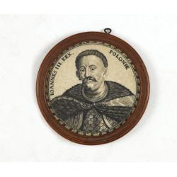
Ioannes III. Rex. Poloniae (Portrait of Johann III. Sobieski)
On verso a text in brown ink "1674 Giovanni Sobieski Gran Maresciallo della Polonia, che poscia lo fece suo Re, perchè a Cokrim vinse li Turchi, e la liberò dai tr...
Date: Ulm, ca. 1690
Cercle de Westphalie.
Fine map of Westphalia. The address is much re-worked, now with the address Chez L'Autheur aux Galleries du Louvre , dated 1690.This edition carries the date 1690 and the...
- $100 / ≈ €85
Date: Paris 1690
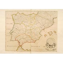
Hispaniae Antiquae Tabula.
A fine map of ancient Spain, Portugal and Majorca, etc.This edition carries the date 1641 and in manuscript pencil 1690.Nicolas Sanson was to bring about the rise of Fren...
- $200 / ≈ €170
Date: Paris, 1641-1690
Esseker brugh.
Fine print of the Esseker bridge in Osijek. Etched by Gaspar Bouttats (1640-1695).The Antwerp based publisher Jacques Peeters published ca. 1690 a series of prints relate...
- $125 / ≈ €106
Date: Antwerp, c.1690
Guyla.
Magnificent bird's eye- of Gyula. Etched by Gaspar Bouttats (1640-1695).The Antwerp based publisher Jacques Peeters published ca. 1690 a series of prints related to the H...
- $125 / ≈ €106
Date: Antwerp, c.1690
Tabula ducatus Limburch et comitatus Valckenburch. . .
The map describes the southern part of Limburg and reaches into Belgium (Liége, Verviers) and Germany. With two very decorative cartouches.
Date: Amsterdam, 1690

Les vallées du Piemont. Habitees par les Vaudois ou Berbets. . .
Detailed map of Piedmont region covering French and Italian territories. Surrounded by a French text description "Description des vallées du Piemont qu'habitent par...
Date: Paris, 1690
Sandrae. (Szendrö)
Magnificent bird's eye- of Szendrö. Etched by Gaspar Bouttats (1640-1695).The Antwerp based publisher Jacques Peeters published ca. 1690 a series of prints related to th...
- $100 / ≈ €85
Date: Antwerp, c.1690

Isola d'Oleron, nella piaggie occidentali della Francia.
A beautiful and rare map showing île d'Oleron.The remarkable Vincenzo Coronelli (1650-1718), encyclopaedist, geographer, inventor and Doctor of Theology, was citizen of ...
Date: Venice, 1690
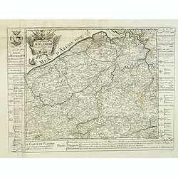
Le Comté de Flandre par P. Placide Augustin. . .
Detailed map of Flanders prepared by P. Placide Augustin, with fine title cartouche and dedication to "Monseigneur Le Marquis de Torcy, Secretaire d'État" in u...
- $350 / ≈ €297
Date: Paris, 1690
Contado DE Venassino, E prencipato d'Oranges . . .
A most attractive and decorative map centered on Avignon and Orange, by Vincenzo Coronelli. An elaborate title cartouche garlanded with intertwined flowers and dedicated ...
- $400 / ≈ €340
Date: Venise 1690

Tabula ducatus Limburch et comitatus Valckenburch. . .
The map describes the southern part of Limburg and reaches into Belgium (Liege, Verviers) and Germany. With two very decorative cartouches.
Date: Amsterdam, 1690
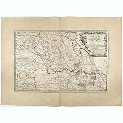
Partie Septentrionale de l'Evesché de Poictiers. Partie Septentrionale du Haut Poitou.
Rare map engraved by R. Michault and published "a Paris chez Greg. Mariette sur le quay de l'Horloge au dessus de la cour de Lamoignon". Dedicated to the Bishop...
Date: Paris, 1690
Transisalania provincia vulgo Over-Yssel auctore N.ten Have
Detailed map prepared by Nico ten Have.
Date: Amsterdam, 1690
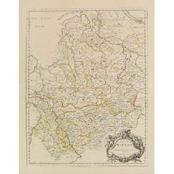
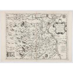
Parte della Schiavonia, overo Slavonia, aggiuntavi la contea di Cilles e Windisch mark abitate da populi slavini, ò slavi. . .
The map of Slavonia by Cantelli from his atlas “Mercurio Geografico” issued in Rome in 1690 by the publisher and printer Giacomo Rossi. The map shows parts of the med...
- $400 / ≈ €340
Date: Rome, 1690
Rechnitz / Lewentz. (Breznica and Levice)
Magnificent bird's eye- of Breznica and Levice in Slovenia. Etched by Gaspar Bouttats (1640-1695).The Antwerp based publisher Jacques Peeters published ca. 1690 a series ...
- $150 / ≈ €127
Date: Antwerp, c.1690
Haftwan. (Hatvan)
Magnificent bird's eye- of Hatvan. Etched by Gaspar Bouttats (1640-1695).The Antwerp based publisher Jacques Peeters published ca. 1690 a series of prints related to the ...
- $100 / ≈ €85
Date: Antwerp, c.1690
Villeck. (Filakovo)
Magnificent bird's eye- of Filakovo. Etched by Gaspar Bouttats (1640-1695).The Antwerp based publisher Jacques Peeters published ca. 1690 a series of prints related to th...
- $150 / ≈ €127
Date: Antwerp, c.1690
Le Coste della Francia sul Mare Oceano.
Uncommon map from "Mercurio Geografico", published in Rome by G. de Rossi. A decorative title and scale cartouches enriching the map. The Italian cartographer C...
- $375 / ≈ €319
Date: Rome, 1690
Tockay. (Tokaj)
Magnificent bird's eye- of Tokaj. Etched by Gaspar Bouttats (1640-1695).The Antwerp based publisher Jacques Peeters published ca. 1690 a series of prints related to the H...
- $150 / ≈ €127
Date: Antwerp, c.1690
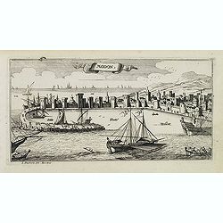
Modon. (Methoni)
Magnificent bird's eye-town-view of Methoni on Morée. Etched by Gaspar Bouttats (1640-1695).The Antwerp based publisher Jacques Peeters published ca. 1690 a series of pr...
- $150 / ≈ €127
Date: Antwerp, c.1690
St:Servaes. (Szarvas)
Magnificent bird's eye- of Szarvas. Etched by Gaspar Bouttats (1640-1695).The Antwerp based publisher Jacques Peeters published ca. 1690 a series of prints related to the...
- $150 / ≈ €127
Date: Antwerp, c.1690
Sixo / Kalo. (Szikszo and Nagycallo)
Magnificent bird's eye- of Szikszo and Nagycallo. Etched by Gaspar Bouttats (1640-1695).The Antwerp-based publisher Jacques Peeters published ca. 1690 a series of prints ...
- $75 / ≈ €64
Date: Antwerp, c.1690

Magnae Prussiae Ducatus Tabula denuo correcta et in lucem edita per Nicolaum Visscher.
Striking old color example of Visscher's map of Prussia and part of the Baltic region. Includes a gorgeous cartouche and banner key held aloft by 2 cherubs, plus 4 sailin...
- $1500 / ≈ €1275
Date: Amsterdam, 1690

Citta, porto, e rada di Brest, e . . . Nella Bretagna . . .
A beautiful and rare map of Bretagne. In top right an inset with the town of Brest.The remarkable Vincenzo Coronelli (1650-1718), encyclopaedist, geographer, inventor and...
Date: Venice, 1690
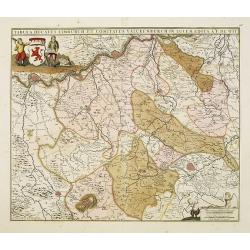
Il Ducato di Silesia et il Marchesato di Moravia
Scarce two-sheet map of the region along the River Oder in Poland, including parts of Chez Republic and Hungary. Excellent detail throughout. Large and decorative title a...
- $1200 / ≈ €1020
Date: Rome, 1692
La seigneurie d'ouest-Frise ou Frise Occidentale
Fine map of the Friesland with a decorative title and scale cartouche.Alexis-Hubert Jaillot (1632-1712), was a French cartographer. He joined the Sanson heirs and redrew ...
Date: Amsterdam, 1692
Le Cercle de Westphalie . . .
Fine map of the Westphalia Duchy with a decorative cartouche and small scale of miles.Alexis-Hubert Jaillot (1632-1712), was a French cartographer. He joined the Sanson...
- $150 / ≈ €127
Date: Amsterdam, 1692