Search Listings matching "schenk" in Europe
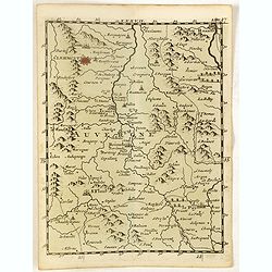
(Ochfenfurt, Hall, Bavaria, etc.)
Rare miniature map of Bavaria including the towns of Ochfenfurt, Hall, etc. From "Le theatre De Bellone, Contenant 48. nouvelles Cartes Geographiques, Des Païs-Bas ...
- $60 / ≈ €52
Date: Amsterdam, 1710
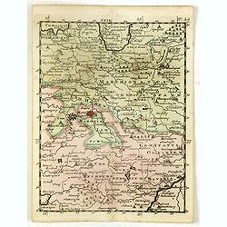
(Clermont, Brioude, Le Puy, etc.)
Rare miniature map including the towns of Clermont, Brioude, Le Puy, etc. From "Le theatre De Bellone, Contenant 48. nouvelles Cartes Geographiques, Des Païs-Bas Es...
- $60 / ≈ €52
Date: Amsterdam, 1710
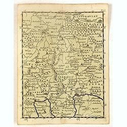
(Hildesheim, Munden, Steinbrugge, Grubenhagen, etc.)
Rare miniature map including the towns of Hildesheim, Munden, Steinbrugge, Grubenhagen, etc. From "Le theatre De Bellone, Contenant 48. nouvelles Cartes Geographique...
- $60 / ≈ €52
Date: Amsterdam, 1710
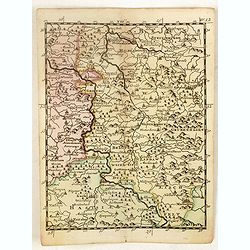
(Schweinfurt, Reineck, Hirschfeld, etc.)
Rare miniature map including the towns of Schweinfurt, Reineck, Hirschfeld, etc. From "Le theatre De Bellone, Contenant 48. nouvelles Cartes Geographiques, Des Païs...
- $60 / ≈ €52
Date: Amsterdam, 1710
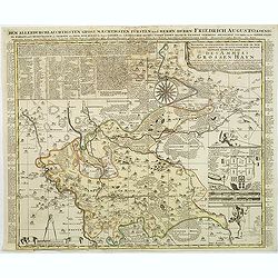
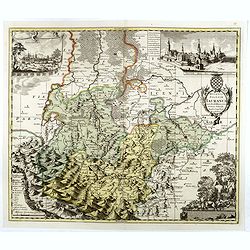
Accurate geographische delineation der in dem Meisnichen creisse des chufurstenthums sachsen liegenden dioeces oder des ammtes grossen hayn
Very detailed map prepared by Adam Frederic Zürner (1680-1742). Surrounded with legends and decorated in the lower right corner with a plan of a royal campement. The tow...
- $90 / ≈ €77
Date: Amsterdam, 1711
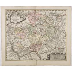
Nassovia Principatus Cum omnibus ei pertinentibus Comitatibus Dominiis ac Praefecturis ut et Confiniis intra Lahnun, Rhenum, et Moenum Flumina, ad situm verum exacte delineatus a Joh. Jac. Stetter. U.J.L. Idstenio-Nassovio . . .
Decorative map of the area between the rivers Rhine and Meuse, including Mainz, Koblenz, Frankfurt, Saarbrucken, etc.Includes an elaborate cartouche and coat of arms.The ...
- $150 / ≈ €129
Date: Amsterdam, 1720
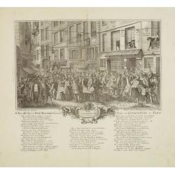
Rue Quinquempoix en l'année 1720. De regte afbeelding der wind negotie gehouden in de straat van Quinquempoix tot Parys.
A true picture of the wind trade of the rue Quinquempoix, Paris, in 1720, taken from "Het groote tafereel der dwaasheid : vertoonende de opkomst, voortgang en onderg...
Date: Amsterdam, 1720
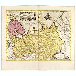
Russiae vulgo Moscovia dictae, Partes Septentrionalis. . .
In the north the Murmansk Sea. Including the western coast of Nova Zembla. Title cartouche and two cartouches, the bottom right one showing two hunters, bears, stags etc....
Date: Amsterdam, 1720
Ducatus Silesiae Iauranus. Aut : Frid : Kühnovio. . .
Rare Pieter Schenk edition of Friedrich Kubn's (Kühnovio) map of Jawor in southwest Poland based on Johann Gottfried Bartsch, map first published in Świdnica (then Schw...
Date: Amsterdam, 1700-1725
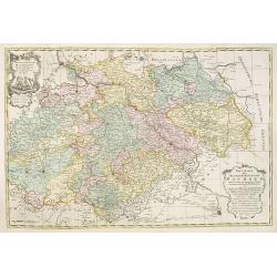
Neue Karte des Kuhrfürstenthums Sachsen. . .
Scarce road map, first published by Peter Schenk II (1698-1775) in his "Neuen Sächsischen Atlas". It is based on a map already created and 1732 and improved in...
- $750 / ≈ €644
Date: Amsterdam, 1758

Gesigt van den Vermaakelyken Overtoom ... der stad Amsterdam....
A view of the Overtoom in the eighteenth century. Etching on two joined sheets of paper, after A.Rademaker. By the eighteenth century, numerous country villas had been bu...
Date: Amsterdam, 1760