Search Listings matching "Theodor" in Europe
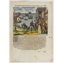
Prima Columbiin Indiam navigation Anno 1492.
Christopher Columbus and the Pinzon brothers leaving the port of Palos in Spain on August 3, 1492 for the New World. Right The King and Queen of Portugal Catholic Ferdina...
Date: Frankfurt, 1594
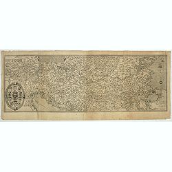
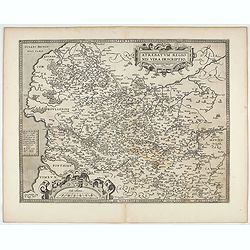
Nova exactissimaque descriptio Danubii.
Rare loose impression of de Jode's map of the Danube with the surrounding countries with de Jode's imprint replaced by Theodor Galle's one. Without letterpress text on ve...
- $4000 / ≈ €3434
Date: Antwerp, 1600
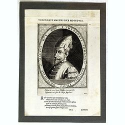
Theodorus Iohannis Basilidis Filius Moscoviae Magnus Dux / Atrium Heroicum.
Lettered with title around oval and two lines of Latin in lower margin: 'Mitior hic rexit ... / ... fato, de stirpe suprémus'. Lettered in letterpress above the platemar...
- $50 / ≈ €43
Date: Augsburg, 1601-1604

Flandria.
Very decorative, egg-shaped map. This is the last and very rare third state with the signature Theodorus Galle. The fortifications along the Scheldt River are added and t...
- $1000 / ≈ €858
Date: Antwerp, after 1612
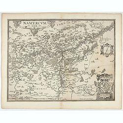
Namurcum Comitatus.
Prepared by Jacques Surhon in 1555. His manuscript map was for security reason not published. Only in 1579, when Antwerp was independent for a short time, Ortelius used a...
- $500 / ≈ €429
Date: Antwerp, after 1612
Artois. Atrebatum Regionis Vera Descripto.
Prepared by Jacob Surhon who made a manuscript map of Artois for which he received 36 Livres from Charles V in 1554. For security reasons the map was not published. Only ...
- $500 / ≈ €429
Date: Antwerp, after 1612
![[L'Hermite's fleet moors in the Solent for repairs.]](/uploads/cache/40472-250x250.jpg)
[L'Hermite's fleet moors in the Solent for repairs.]
In March 1623, a heavily armed fleet of 11 ships, under the command of Jacob l’Hermite, sailed from Holland with the ambitious hope of ‘destroying the Spanish in Amer...
Date: Frankfurt, M.Merian, 1633
![[John Smith caught by the French.]](/uploads/cache/40473-250x250.jpg)
[John Smith caught by the French.]
In 1615, during one of John Smith’s voyages across the Atlantic, he was caught by some French pirates. While at sea in captivity he was forced to suffer great hardships...
- $75 / ≈ €64
Date: Frankfurt, M.Merian, 1633
![[John Smith caught by the French].](/uploads/cache/41114-250x250.jpg)
[John Smith caught by the French].
In 1615, during one of John Smith’s voyages across the Atlantic, he was caught by some French pirates. While at sea in captivity he was forced to suffer great hardships...
Date: Frankfurt, M.Merian, 1633
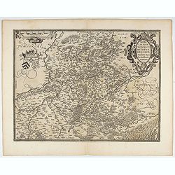
Nobilis Hannoniae Comitatus Descrip.
Fine map of Hannonia (Hainaut), with ornate cartouches, two coats of arms, etc. Showing the cities of Charleroi, Mons, Ath, Tournay, Valenciennes, Maubeuge, etc. in Belgi...
- $600 / ≈ €515
Date: Antwerp, 1612-1641

Novissima Flandriae Comitatus tabula. . .
Rare issue of Theodorus Danckert's attractive map of eastern Belgium provinces, Flanders, with Brugge, Oostende, Gent, Mons, Antwerp, Cambray, etc..Decorative title carto...
Date: Amsterdam, 1700
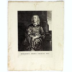
Theodorus Primus Corsicae Rex.
Portrait of Everard Jabach, three-quarter length, standing by the fragment of a column, facing left, wearing a cloak and doublet with plain collar, his left arm held behi...
Date: Paris, 1652 - 1800

Exposé des travaux astronomiques en Russie (Atlas) with Supplément à l’exposé des travaux astronomiques et géodésiques exécutés en Russie contenant les noms, en langue russe de toutes les positions données au chapitre V (supplément I only).
Very rare atlas published to accompany Exposé des travaux astronomiques et géodésiques exécutés en Russie dans un but géographique jusqu’à l’année 1855. St.-P...
Date: St. Petersburg, Imperial Academy of Sciences: Eggers & Co., and Leipzig, Leopold Voss, 1858