Browse Listings in Asia > Near / Middle East
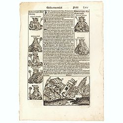
Quinta Etas Mudi. Folium. LXV (With view of Babylon)
The Latin text page is illustrated with an imaginary of the Ancient City of Babylon (Dim. H : 138 mm W : 223 mm).Babylon was the capital of Babylonia, the alluvial plain...
Date: Nuremberg, 12 July 1493
![.[Pakistan, Afghanistan]](/uploads/cache/33849-250x250.jpg)
.[Pakistan, Afghanistan]
Wood block printed Ptolemaic map of the region of present-day Pakistan and part of Afghanistan. Convoluted mountain ranges and river systems dominate the trapezoidal map....
Date: Vienna, Trechsel, G., 1525 -1541
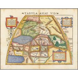
Tabula Asiae VII.
Attractive woodblock map, depicting the Caspian Sea, Black Sea and the Persian Gulf, extending to the Imaus Mountains. according to Ptolemy. In the center of the map is...
Date: Basle, 1542
![Tabula Asiae III [Black & Caspian Sea Region]](/uploads/cache/41831-250x250.jpg)
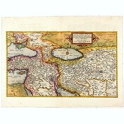
Tabula Asiae III [Black & Caspian Sea Region]
Attractive woodblock Ptolemaic map, depicting Armenia and in the Right part of the Caspian Sea with Noes Arch, believed to have come to rest in a mountain in Armenia acco...
Date: Basel, Heinrich Petri, 1545
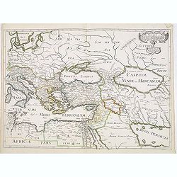
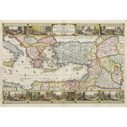
Primae Partis Asiae.
The Very Rare First State. Turkey/ Holy Land/ Iran/ Iraq/ Arabia/ Afghanistan. A superb example of the rare 1578 edition of this fine map of the Middle East, spanning fro...
- $4500 / ≈ €3890
Date: Antwerp, 1578
Romani Imperii Oriens est Descriptio Geographica. . .
A fine map of the Near East. The map was first published by Tavernier and later by Mariette. This edition is dated 1637 with the address of Pierre Mariette at rue S. Jacq...
Date: Paris, after 1637
Geographische Beschryvinghe van de wandeling der apostelen ende De Reysen Pauli. . .
In upper and lower part 9 vignettes showing scenes from Paul's wanderings.
- $500 / ≈ €432
Date: Amsterdam, 1660
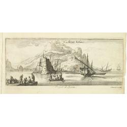
Tripoli de Soria.
Magnificent bird's eye- of Tripoli in Lebanon. Tripoli is located 85 km north of the capital Beirut, and is the easternmost port of Lebanon. Etched by Gaspar Bouttats (16...
- $100 / ≈ €86
Date: Antwerp, c.1690
Armenia Vetus In Quatuor Partes..
Uncommon Italian version of a map of ancient Armenia prepared by Philip de la Rue. The map describes the four regions of Armenia, Greater Armenia, Second, Third and Fourt...
Date: Padua, 1694
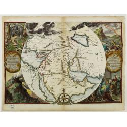
Orbis Per Creationem Institutus.
This is a very unusual map depicting the region from Asia Minor to India and including all of the Arabian Peninsula within a circle. The Garden of Eden is prominently dis...
- $750 / ≈ €648
Date: Amsterdam, 1700
![Bagdat le plan de Bagdat. [Manuscript plan of Bagdad]](/uploads/cache/45364-250x250.jpg)
Bagdat le plan de Bagdat. [Manuscript plan of Bagdad]
Manuscript plan of Baghdad, being a close copy of 'Les Six Voyages de Jean-Baptiste Tavernier en Turquie, en Perse et aux Indes' (1676). With a lettered key 1-16 to impor...
Date: France, ca. 1700
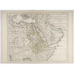
Carte de L'Egypte de la Nubiede L'Abissinie. . .
Including the Arabian Peninsula. Giving good detail on Egypt. Engraved by Desrosiers.More about Mapping of Arabia [+]
- $300 / ≈ €259
Date: Paris, 1707
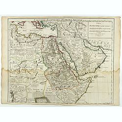
Carte de L'Egypte de la Nubie de L'Abissinie..
Including the Arabian Peninsula. Giving good detail on Egypt. Engraved by Desrosiers. Address and date changed, now with the imprint "A Paris Chez l’Auteur sur le ...
Date: Paris, November 1707
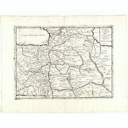
Cilicia Asiae Minoris pars orientalis. . .
Uncommon map of Cilicia, an ancient region and former kingdom of SE Asia Minor, between the Taurus Mountains and the Mediterranean: corresponds to the region around prese...
Date: Paris/ Bordeaux, 1726
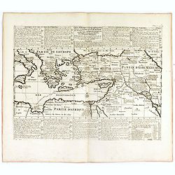
Carte historique et géographique pour servir à l'Histoire Sainte et à la Vocation de Saint Paul, avec quelques remarques curieuses pour servir à l'Histoire des Antiquités judaïques.
Interesting sheet with a map of the travels of Saint Paul, including eastern part of Europe, Asian continent and part of north Africa, with descriptive French text, from ...
Date: Amsterdam, 1728

Alexandri Magni Imperium et Expeditio. . .
The map represents the theatre of Alexander the Great's conquests between the Black Sea and Indus River, today's Turkey, Armenia, Iraq, Iran, Afghanistan, etc. The map is...
- $100 / ≈ €86
Date: Paris, 1731
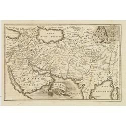
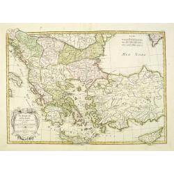
Oriens, Persia, India etc.
Uncommon map of Persia, Armenia, Arabian Peninsular and part of India. Prepared by Christoph Cellarius (1638-1707). From Geographia Antiqua...
Date: Leipzig, Gledisch, 1732
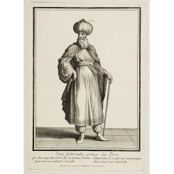
Emir Fechrredin prince des Drus.
Engraving published by Nicolas Bonnart (c.1637 - 1718), engraver in Augsburg since 1719. Before the nineteenth century, portraits of rulers in the Middle East were a rari...
Date: Paris, ca. 1740
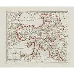
Turquie Asiatique..
Small detailed map of the Near East, including Cyprus, the Black Sea and Georgie. From Atlas Portatif Universel, by Robert de Vaugondy.Page 65 outside border top right. M...
- $100 / ≈ €86
Date: Paris, later than 1748
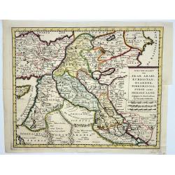
Irak, Arabi, Kurdistan, Diarbek, Turkomania, Syrie en het Heilige Land.
Isaak Tirion's map of the Near East. His 'Nieuwe en beknopte handatlas' saw 6 editions between before 1740 and after 1784. Also the 'Atlas van de Nederlandse Provintien' ...
- $350 / ≈ €303
Date: Amsterdam, ca. 1750
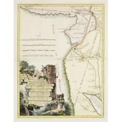
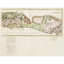
Carte de la Babylonie nommée aujourd'hui Hierac-Arab avec les noms, tant anciens que modernes et les routes des expéditions de Cyrus et de Julien l'Apostat, aussi bien que celles de Teixera, Benjamin. . .
A very fine map centered on Arabia and in top Iraq with Baghdad. With a very attractive title cartouche on the lower left-hand corner. Published by Joseph-Nicolas De l' I...
- $550 / ≈ €475
Date: Paris/ Bordeaux, 1766
Turquie d'Europe et partie de celle d'Asie…
An attractive map of Turkey, Greece, Cyprus. Prepared by Janvier.
Date: Paris, 1771
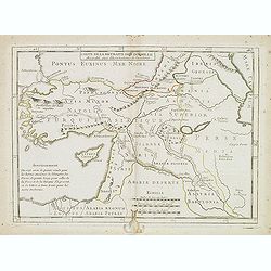
Carte de la retraite des dix mille. . .
Ancient map of Near and Middle East, including Cyprus, prepared by Nolin and published by L.J. Mondhare for his Atlas Général a l'usage des colleges et maisons d'educat...
- $50 / ≈ €43
Date: Paris, 1781
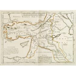
Carte de la Retraite des Dix Mille Accordée aux Observations de l'académie. . .
Ancient map of Near and Middle East prepared by J.B.Nolin and published by Monhare for his Atlas Général a l'usage des colleges et maisons d'education.. Centered on Cyp...
- $100 / ≈ €86
Date: Paris, 1783
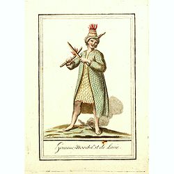
Homme nord est de l'Asie.
Originally hand-colored mezzotint of Native Americans engraved by Félix Mixelle and Lachaussée Jeune after Jacques Grasset de Saint-Sauveur.As an etcher, drawer and wri...
- $50 / ≈ €43
Date: Paris,1801-1806
![[Afganistans in their typical dress]](/uploads/cache/62332-250x250.jpg)
[Afganistans in their typical dress]
Aquatint showing local of Afghanistan in their typical dress. Plate N° 3.From Giulio Ferrario's work Le Costume ancien et moderne ou histoire du gouvernement, de la mili...
- $50 / ≈ €43
Date: Milan, 1827
![[Costume plate of locals of Afganistan]](/uploads/cache/62331-250x250.jpg)
[Costume plate of locals of Afganistan]
Aquatint showing locals of Afghanistan in their typical dress. Plate N° 2. Engraved by D.K.Bonatti.From Giulio Ferrario's work Le Costume ancien et moderne ou histoire d...
- $60 / ≈ €52
Date: Milan, 1827
![[Costume plate of locals of Dourans tribe in Afganistan]](/uploads/cache/62330-250x250.jpg)
[Costume plate of locals of Dourans tribe in Afganistan]
Aquatint showing locals of Dourans tribe in Afghanistan in their typical dress. Plate N° 1. Engraved by C. Bottigella.From Giulio Ferrario's work Le Costume ancien et mo...
- $50 / ≈ €43
Date: Milan, 1827
![[Family from Kyrgyz Republic - Costumes des Kirguises]](/uploads/cache/24477-250x250.jpg)
[Family from Kyrgyz Republic - Costumes des Kirguises]
Aquatint engraved by D.K. Bonatti, after drawings by C. Bottigella. Showing a family in typical dress from the Kyrgyz Republic. Man is holding a bird.In the late nineteen...
- $70 / ≈ €61
Date: Milan, 1827
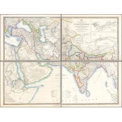
Map of the Countries lying between Turkey & Birmah, Comprising Asia Minor, Persia, India, Egypt & Arabia, and including the Black, Caspian & Red Seas 1841
This striking 4-sheet map, dating to the first half of the 19th century, covers a vast region stretching from Cyprus to Bhutan on the upper sheets and from Egypt to Thai...
Date: London, 1841
AFGHAN de CABOULE. Costumes Persans 8.
A beautiful hand colored lithograph of an elegant Afghan from Kabul published in the French work "Galerie Royale de Costumes peints d´après nature par divers artis...
Date: Paris, Chez Aubert & Cie., 1842-1848

Carte géologique détaillée. Beyrouth.
Geological or soil map showing part of Lebanon with Beyrouth, including in top a colored legend with signs of the different geological ages. Provenance : Fondation P. Fal...
Date: Liban, Service geographique des F.F.L., 1945.

Carte geologique detaillee. Jbail.
Geological or soil map showing part of Lebanon with Jbail antique Byblos Ancien Port phenicien / scale 1 : 50 000., including a legend with signs of the different geologi...
Date: Liban, Service geographique des F.F.L., 1945.

Carte géologique détaillée. Zahle.
Geological map showing part of Lebanon with Zahle. , including a legend with signs of the different geological ages. Provenance : Fondation P. Fallot
Date: Liban, Service geographique des F.F.L., 1945.

Carte géologique détaillée. Râchaïya Nord.
Geological or soil map showing part of Lebanon with Râchaïya , including a legend with signs of the different geological ages and giving many informations of greatest i...
Date: Liban, Service geographique des F.F.L., 1945.

Carte géologique détaillée. Jezzîne.
Geological or soil map showing part of Lebanon with Jezzîne, including a legend with signs of the different geological ages and giving many information of greatest inter...
Date: Liban, Service geographique des F.F.L., 1945.
