Browse Listings in Asia > China > China General

Tabula Superioris Indiae & Tartariae maioris. (Modern Map of China, Japan, etc.)
Important map extending from Tartary in the north, to "Prov. Bocat" (Cambodia) in the south. "Tebet" is shown prominently, as is "Zinpangri"...
Place & Date: Vienne, 1541

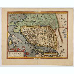
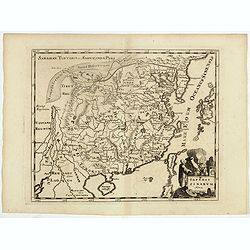
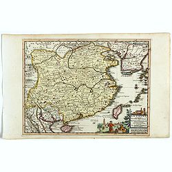
Chinae, olim Sinarum Regionis, nova descriptio. Auctore Ludovico Georgio.
The first map of China ever to appear in a Western atlas, west to the top. The first state without "las Philiooinas" somewhere in 1587 added to the plate. When ...
Place & Date: Antwerp, 1584
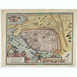
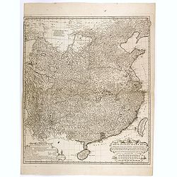
Chinae, olim Sinarum Regionis, nova descriptio. Auctore Ludovico Georgio.
The first map of China ever to appear in a Western atlas, west to the top. The second state with "Las Philipinas" somewhere in 1587 added to the plate. When thi...
- $6000 / ≈ €5614
Place & Date: Antwerp, 1592

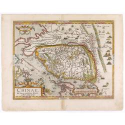
Chinae, olim Sinarum regionis. . .
The first printed map of China. It is signed by Ludovico Georgio, whose real name was Luis Jorge de Barbuda. He was a Portuguese Jesuit cartographer and besides that a sp...
Place & Date: Antwerp, 1598
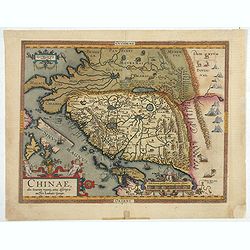
Chinae, olim Sinarum regionis. . .
The first printed map of China. It is signed by Ludovico Georgio, whose real name was Luis Jorge de Barbuda. He was a Portuguese Jesuit cartographer and besides that a sp...
Place & Date: Antwerp, 1598
Chinae, olim Sinarum regionis. . .
The first printed map of China. It is signed by Ludovico Georgio, whose real name was Luis Jorge de Barbuda. He was a Portuguese Jesuit cartographer and besides that a sp...
- $6000 / ≈ €5614
Place & Date: Antwerp, 1608
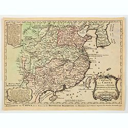
Chinae, olim Sinarum Regionis, nova descriptio. Auctore Ludovico Georgio.
The first map of China ever to appear in a Western atlas, west to the top. When this map appeared, it was by far the most accurate one of China.The map is based on a manu...
- $5500 / ≈ €5146
Place & Date: Antwerp, 1608 /1612
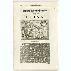
China.
Small map illustrating China with the Great Wall and Korea as an island, surrounded by text in Dutch.Nicolaes de Clerck (de Klerc) was active as engraver and publisher in...
- $200 / ≈ €187
Place & Date: Amsterdam, Cloppenburch, 1621
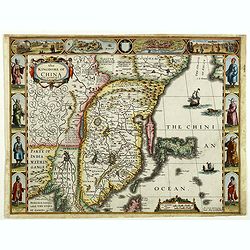
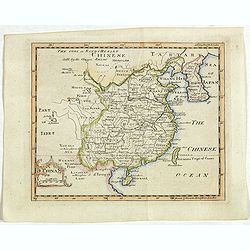
The Kingdome of China.
A most sought-after map of China. Decorative border vignettes including views of the cities of Quinzay and Macao along the top border with the wheeled wind machines and p...
Place & Date: London, G. Humble, 1626

The Kingdome of China.
A most sought-after map of China. Decorative border vignettes including views of the cities of Quinzay and Macao along the top border with the wheeled wind machines and p...
Place & Date: London, G. Humble, 1627
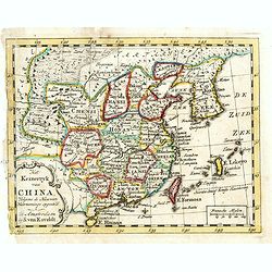
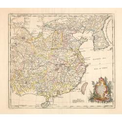
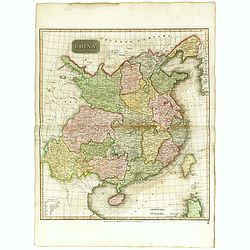
China Veteribus Sinarum Regio nunc Incolis Tame dicta.
Fine map of China, based on the first of Blaeu's maps of China. In the west by the Great Wall is shown, among Taiwan is named Pakan al I. Formosa, although Tayoan is name...
- $950 / ≈ €889
Place & Date: Frankfurt am Main, 1638

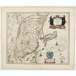
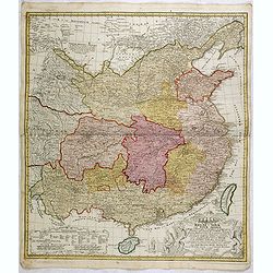
China Veteribus Sinarum Regio.
Based on Jesuit surveys, the map represents the next major revision in the cartography of China after Ortelius' 1584 map. Korea, however, is still an island, and Japan co...
Place & Date: Amsterdam, 1640
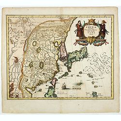
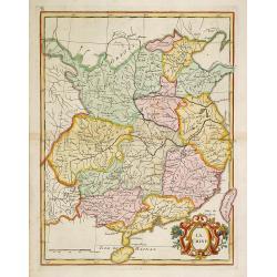
China Veteribus Sinarum Regio.
This was the first of Blaeu's maps of China. In 1655 he was to publish the famous map of Father Martini, with many of the earlier inaccuracies present on this map correct...
- $2200 / ≈ €2059
Place & Date: Amsterdam, 1644
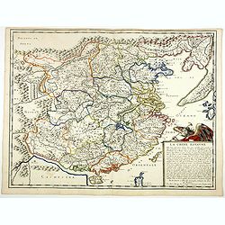
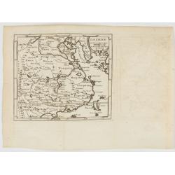
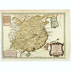
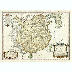
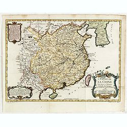
La Chine Royaume. . .
An important and attractive French map of the whole of China, the northern tip of the Philippines, with a strangely curved Korea and an under-sized Taiwan here called &qu...
- $2600 / ≈ €2433
Place & Date: Paris, 1656
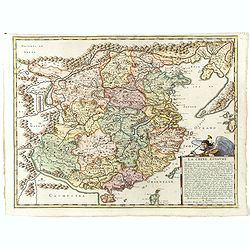
La Chine Royaume. . .
An important and attractive French map of the whole of China, northern tip of the Philippines, with a strangely curved Korea and an under-sized Taiwan here called "Y...
Place & Date: Paris, 1656
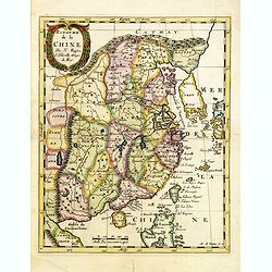
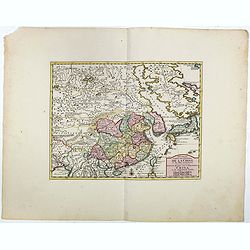
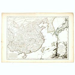
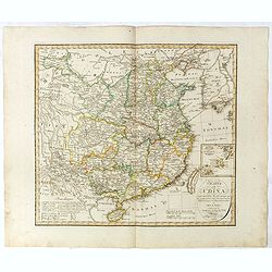
Imperii Sinarum nova descriptio.
Schenk and Valk's rare early 18th century issue of Janssonius milestone map of China, Korea and Japan after Martino Martini. Engraved by Johannes van Loon. The overall ba...
- $1600 / ≈ €1497
Place & Date: Amsterdam, ca. 1660

La Chine.
Rare map of China, Korea (as an island) and Japan, published by Jollain in 1667. In upper right corner part of North America. Published in "Trésor Des Cartes Geogra...
- $350 / ≈ €328
Place & Date: Paris, 1667

An embassy from the East-India Company of the United Provinces, to the Grand Tartar Cham, Emperor of China deliver'd by their excellencies, Peter de Goyer and Jacob de Keyzer, at his imperial city of Peking. . .
Very rare first English text edition of this most important and early resource on China and the Chinese. Three parts in one folio by John Macock for the author.Part I: An...
Place & Date: London : Printed by the Author at his house in White-Friers, 1669

La Chine d'Athanase Kirchere de la compagnie de Jesus, illustrée de plusieurs monuments tant sacrés que profanes et de quantité de recherches de la nature. . .
Athanasius Kircher, S.J., (1601 or 1602-1680) was a 17th-century German Jesuit scholar who published around 40 works, most notably in the fields of oriental studies, geol...
Place & Date: Amsterdam, 1670

Il regno della China detto presentente Catay e Magnin. . .
A rare and decorative Italian map of China and Japan, with Japan closely modelled on the indented Cardim outline and Hokkaido, called Yuppi , shown as an Asian peninsula....
Place & Date: Rome, 1682
Royaume de la Chine. . .
Detailed map of China. Engraved by A.Winter. Attractive miniature map, depicting Korea as an island and parts of Japan, i.e. western part of Honshu and Kyushu.
- $450 / ≈ €421
Place & Date: Utrecht, 1683

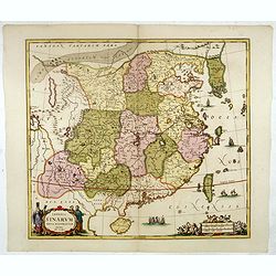
Paradigma XV Provinciarum et CLV Urbium Capitalium Sinensis Imperij Cum Templis quae Cruce X Signatur Et Domiciliis S.I.
First edition of this rare Jesuit map of China, published by Jean Baptiste Nolin in Paris and based on Philippe Couplet's map of 1686. The map shows China's 15 provinces ...
- $2400 / ≈ €2246
Place & Date: Paris, 1686

Het gezandtschap der Neerlandtsche Oost-Indische Compagnie, aan den grooten Tartarischen Cham, Den tegenwoordigen Keizer van China. . .
Third edition of this beautifully illustrated work on China. The first edition was published in 1665.Jan Nieuhof was a "Dutch traveler and adventurer" (1618-72)...
Place & Date: Amsterdam, W. Waasberge, 1693

Parte orientale della China.. / Parte occidentale della China. (2 sheets)
The map depicts the eastern part of China with Korea -correctly- as a peninsula. Formosa is included as well. Japan is partly visible i.e. the area of Yamaguchi, strait K...
Place & Date: Venice, 1695
Imperii Sinarum Nova Descriptio.
Interesting map of China, shows the Great Wall, Macao and the Island of Formosa. From Philipp Clüver's famous Introductionis in Universam geographicam, first published i...
- $300 / ≈ €281
Place & Date: Amsterdam, 1697

Collection of rubbings with portraits and biographies of famous Chinese philosophers, poets and legendary wise old men.
Collection of portraits and biographies of famous Chinese philosophers, poets and legendary wise old men. All portraits and text are original rubbings from stone tables d...
- $15000 / ≈ €14036
Place & Date: China or Korea, c. 1701
The Modern History, by way of sequel to Mr. Rollin's ancient history. Vol. I. Containing the history of China.
A rare book translated from French and printed for J.& P. Knapton. The volume is divided into a number of parts, covering a general history of China, a description of...
Place & Date: London, 1704
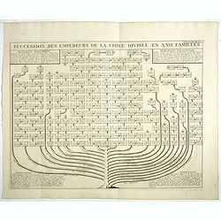
Succession Des Empereurs De la Chine divisée en XXII. Familles.
Showing successions of the Emperors of China divided into 22 families, copper engraved plate from "Atlas Historique". Zacharie Chatelain (d.1723) was the father...
- $100 / ≈ €94
Place & Date: Amsterdam, 1720

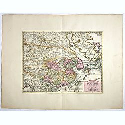
Imperii Sinarum nova descriptio.
Schenk and Valk's rare early 18th century issue of Janssonius milestone map of China, Korea and Japan after Martino Martini. Engraved by Johannes van Loon. The overall ba...
Place & Date: Amsterdam, ca. 1720
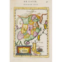
La Chine.
A charming small map of China, Taiwan, Philippines, Korea and Kyushu (Japan). By Allain Manneson Mallet (1630-1706), a well traveled military engineer and geographer who ...
- $300 / ≈ €281
Place & Date: Paris, 1720
La Chine suivant les nouvelles observations...
Uncommon edition of this map of China. From Le Nouveau Theatre du Monde, ou la Geographie Royale.Curious shape of South Korea.
- $1100 / ≈ €1029
Place & Date: Amsterdam, 1728

Hedendaegsche Historie of tegenwoordige staet van alle volkeren 1 deel. (Volume 1 - China, Japan, Phillippines, Moluccas)
This provides an interesting illustrated description of China, Japan, the Phillippines, Moluccas. Including a map of China, Korea, and Japan, with the Sea between Korea a...
Place & Date: Amsterdam, 1734
Description geographique, historique, chronologique, politique, et physique de l'empire de la Chine et de la Tartarie chinoise.
First edition of this cornerstone of any collection of books on China, which is also among the rarest and most desirable of important Americana, included in Rare American...
Place & Date: Paris, P. G. Le Mercier, 1735

Description geographique, historique, chronologique, politique, et physique de l'empire de la Chine et de la Tartarie chinoise . . . du Thibet, & de la Coree. . .
Without the separately published atlas. Lacking 2 plates in vol.2 (Obseques at p.149 and Gin seng at p.180), one plate torn without a loss (vol.1, p.230), d4 vol.1 with a...
Place & Date: The Hague, H. Scheurleer, 1736

The Empire of China and Island of Japan. . .
The map is of interest for the use of East Sea, the sea between Korea and Japan, here called "Sea of Corea". Some interesting notations are made. From his atlas...
Place & Date: London, 1736

Nouvel atlas de la Chine, de la Tartarie chinoise, et du Thibet.
First edition of "the principal cartographic authority on China during the 18th century". It was the second major atlas of China produced in Europe following th...
Place & Date: The Hague, H. Scheurleer, 1737
Carte générale de la Chine Dressée sur les Cartes particulières que l'Empereur Cang-hi a fait lever sur les lieux par les RR. PP. Jésuites missionaires dans cet empire / Par le Sr d'Anville.
Important and very detailed map of Southern part of China, including a detailed Taiwan. Jean Baptiste Bourguignon d' Anville (1697-1782) was a French cartographer and com...
- $1000 / ≈ €936
Place & Date: The Hague, H. Scheurleer, 1737

Carte la plus generale et qui comprend la Chine, la Tartarie chinoise et le Thibet. . .
With a quite elaborately pictorial cartouche, engraved by G.Kondet. Very detailed map of China, Tibet and Korea.Jean Baptiste Bourguignon d' Anville (1697-1782), French c...
Place & Date: The Hague, 1737
La Chine.
A very nice map of China, including Korea and Taiwan. From Francisco Giustiniani for El Atlas abreviado o el nuevo compendio de la Geografia universal, politica, historic...
- $300 / ≈ €281
Place & Date: Leon de Francia (Lyon), Jaime Certa, 1739

Nuova carta dell' Imperio della Chia e dei Paesi circonvicini. / Nueva carta de l'Impario de la Quina.
The map is of interest for the use of Mar di Corea" and "Mar Setentrionale del Giapone" in the sea between Korea and Japan.Rare early edition of Albrizzi's...
Place & Date: Venice, 1740
Het Keizerryk van China, volgens de Nieuwste Waarneminge opgesteld.
A scarce and uncommon miniature map of China, Korea and Taiwan. The map is of interest for the use of De Zuid Zee for the sea between Korea and Japan.
- $300 / ≈ €281
Place & Date: Amsterdam, 1745
Das Kaiserthum China zur allgemeinen Historie der Reisen - entworfen von N. Bellin Ing. De la Mar. 1748.
Attractive and detailed map of China and Korea. The map is of interest for the use of Das Meer von Korea for the coast along the east coast of Korea. The composition is n...
- $500 / ≈ €468
Place & Date: Leipzig, Arkstee & Merkus, 1746
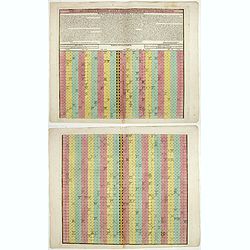
Tabula chronologica historiae Sinicae connexa cum cyclo qui vulgo Kia Tse dictur.
A set of two sheets of colored copper engravings. First published in 1729 in Rome in three sheets. Timeline of China's history with a chronological overview of the dynast...
- $1200 / ≈ €1123
Place & Date: Augsburg, 1746
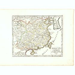
L'Empire de la Chine.
A fine map of China, Korea and Taiwan.Jacques Nicholas Bellin (1703-1772) was one of the most important and proficient French cartographers of the mid-eighteenth century....
- $450 / ≈ €421
Place & Date: Paris, 1748
L'Empire de la Chine. . .
A fine map of China, Korea and Taiwan.Jacques Nicholas Bellin (1703-1772) was one of the most important and proficient French cartographers of the mid-eighteenth century....
- $450 / ≈ €421
Place & Date: Paris, 1748
Empire de la Chine Par le Sr. Robert de Vaugondy fils de Mr. Robert Geog. Ord du Roi avec Privilege 1749.
Small detailed map of China, and Corea, including Taiwan. From Atlas Portatif Universel, by Robert de Vaugondy.Page 165 outside border top right. First and only state.The...
- $150 / ≈ €140
Place & Date: Paris, 1749
Nouvelle Carte de L'Empire De La Chine et les Pais circonvoisins - Nieuwe Kaart van t Keizerryk China en de aangrensende Landen.
Finely engraved map of China and Korea, with titles in both French and Dutch.The map extends west to the Gobi Desert and Tibet and shows Macao and Canton, among other cit...
- $500 / ≈ €468
Place & Date: Amsterdam, 1750
Nouvelle Carte de L'Empire De La Chine et les Pais circonvoisins - Nieuwe Kaart van t Keizerryk China en de aangrensende Landen.
Finely engraved map of China and Korea, with titles in both French and Dutch.The map extends west to the Gobi Desert and Tibet and shows Macao and Canton, among other cit...
Place & Date: Amsterdam, 1750

L'Empire de la Chine. . .
Detailed map of China, Korea and Taiwan. The large title cartouche is resplendent in the French style with musicians, a dancer, and various accouterments representative o...
Place & Date: Paris, dated 1750

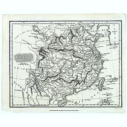
A new & accurate map of the Empire of China from the Sieur Robert's Atlas. With improvements.
An excellent early engraving of China and Korea that appeared in Sieur Robert de Vaugondy's Geographical Dictionary (London: 1759). Decorative title cartouche on the uppe...
Place & Date: London, 1759
China as surveyed by the Jesuit Misionaries between the years 1708 & 1717 with Korea & the adjoining parts of Tartary.
The map is of interest for the use of Eastern Sea or Sea of China, the sea south of Korea. In the sea along the coast line of Korea : "Kau-Li-Qua or King:m of Korea&...
Place & Date: London, c. 1760
Selling price: $500
Sold in 2014
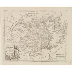
Regni Sinae vel Sinae propriae. . .
General map of China extending to the Gobi Desert in the North, including the islands of Taiwan and Hainan. The map is based on the work of du Halde. An appealing title c...
- $750 / ≈ €702
Place & Date: Nuremberg, 1760
La Chine.
With decorative title cartouche lower right. Good detail of China's mainland with Taiwan and Hainan Province.
- $300 / ≈ €281
Place & Date: Paris, 1767
L'Empire de La Chine../ 't Keizerryk van China..
An attractive map of China with Korea and Taiwan (I.Tay-wan, ou Formosa) and "Mer de Coree'. There are decorative title cartouches in three corners of the map. The u...
- $200 / ≈ €187
Place & Date: The Hague, 1773
China.
A nice mid-eighteenth-century map of China, extending from the island of Hainan in the south, to the Kobi Desert in the north, from Lake Puka in Tibet in the west to Kore...
- $150 / ≈ €140
Place & Date: Edinburgh, 1778
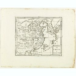
La China e Giapone.
Rare map of China, Korea and Japan, from "Atlante Novissimo ad uso Dei Giovani Studiosi Contenuto In Carte XXVII.", published by Giovanni Zempel in Rome, ca. 17...
- $300 / ≈ €281
Place & Date: Rome, 1780
L'Empire de la Chine d'après l'Atlas Chinois, avec les Isles du Japon..
Attractive map of eastern part of China, including Taiwan, Korea and Japan. With ornamental title cartouche. Boundaries outlined in hand color.From theAtlas moderne ou co...
- $300 / ≈ €281
Place & Date: Paris, ca 1783
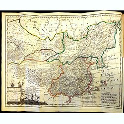
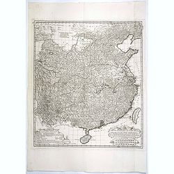
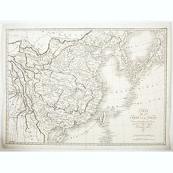
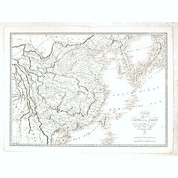
Carte Generale De La Tartarie Chinoise Dressee sur les Cartes Particulieres Faits Sur Les Lieux Par Les R.R. P.P. Jesuites . . . .MDCCXXXII
Very detailed map of Northern China, Japan and Korea. Jean Baptiste Bourguignon d' Anville (1697-1782), French cartographer. d'Anville used maps prepared by Jesuit missi...
Place & Date: Paris, Ph.-D. Pierres, Clousier [- Moutard], 1785
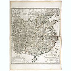
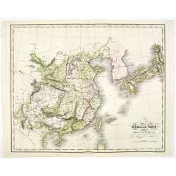
Carte Generale de la Chine Dressée sur les Cartes Particulieres Que l' Empereur Chang-Hi a fait lever sur les lieux..
Large map showing the traditional limits of China, including Hainan and Formosa in the South, and Quantong and parts of the Gobi Desert in the North.As the title notes, t...
Place & Date: Paris, Ph.-D. Pierres, Clousier [- Moutard], 1785
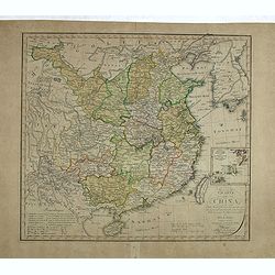
Carte Generale de la Chine Dressée sur les Cartes Particulieres Que l' Empereur Chang-Hi a fait lever sur les lieux. . . .
With a quite elaborately pictorial cartouche, engraved by the master engraver Guillaume-Nicolas de la Haye (1727 -1802). Large map showing the traditional limits of China...
- $750 / ≈ €702
Place & Date: Paris, Dezauche, 1789–1799

La China e Giapone.
Uncommon map of China, Korea, Japan and Taiwan (I.Formosa), only one town labeled, Tayoan. Very strange shape for Japan.The map is of interest for the use of Mar di Corea...
Place & Date: Italy, ca. 1800

Map of China.
Showing China, Taiwan and Korea, divided into provinces with the main cities marked. The map is of interest for the use of Sea of Corea, the sea between Korea and Japan, ...
Place & Date: London, 1804
Charte von China nach Murdochischer Projection entworfen. ... Berichtiget, und gezeichnet von H.F.A. Stieler. . .
Uncommon map of China prepared by H.F.A.Stieler, with parts of Taiwan, Tibet, Mongolia and the Korean peninsula, with a great many place names, a key to (and brief explan...
- $600 / ≈ €561
Place & Date: Weimar, 1804
![Morokoshi Meisho Zue [Illustrated Description of Famous Sites of China].](/uploads/cache/34118-250x250.jpg)
Morokoshi Meisho Zue [Illustrated Description of Famous Sites of China].
Published in Osaka, Kawachiya Genhichiro, et al. [8 book sellers], slightly later issue but apparently in Edo period, using all the same woodblocks of original first edit...
Place & Date: Osaka, Edo, slightly later than Bunka 3, year of the tiger - 1806
L'Empire de la Chine, avec les Isles du Japon, et la Corée.
Map of south eastern China, including Taiwan, Korea and Japan. From Atlas de la Géographie de toutes les parties du monde .. Ouvrage destiné pour l'education, et néces...
Place & Date: Paris, Prudhomme, Levrault, Debray, 1806
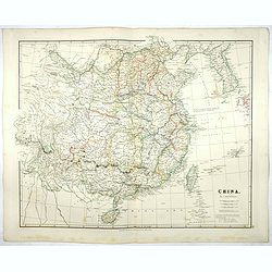
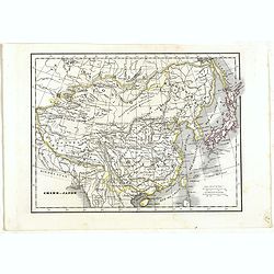
China.
Highly detailed map of China including Formosa (Taiwan), Hainan, and part of Luzon in the Philippines. The map show the Tract of the Hindoostan and Lion with the British ...
Place & Date: Edinburgh, 1815
China.
From the atlas the 'Universal Geography' by Thos. Kelly, and engraved by Finlay. This copper plate maps shows the mainland of China, together with the islands of Formosa ...
Place & Date: London, ca. 1817

Chungguk-do
Chungguk-do [Map of China] taken from a Korean printed Ch’onha chido [Atlas of all under Heaven] which is a 19th century version of the traditional Korean atlas produce...
Place & Date: Korea, ca. 1820
Charte von China nach Murdochischer Projection entworfen. ... Berichtiget, und gezeichnet von H.F.A. Stieler. . .
Uncommon map of China prepared by H.F.A.Stieler, with parts of Taiwan, Tibet, Mongolia and the Korean peninsula, with a great many place names, a key to (and brief explan...
Place & Date: Augsburg, 1820
Carte de la Chine et du Japon..
Engraved by Tardieu for L'Intelligence de l'histoire generale des Voyages de Laharpe .Rare and detailed map of China, Korea, Japan and Taiwan (I.Formose ou Pekan).
- $100 / ≈ €94
Place & Date: Paris, 1821
Carte de la Chine et du Japon. Dressée pour l'intelligence de l'histoire général des voyages de Laharpe. . .
Engraved by Tardieu for L'Intelligence de l'histoire generale des Voyages de Laharpe .Rare and detailed map of China, Korea, Japan and Taiwan (I.Formose ou Pekan).
- $275 / ≈ €257
Place & Date: Paris, 1821
China and Japan drawn and engraved for Dr. Playfairs Atlas.
Detailed map of China, Korea, Japan and Taiwan engraved by H. Cooper and published by Alexander Macredie. Originally engraved for James Playfair's " A New General At...
- $900 / ≈ €842
Place & Date: Edinburgh, 1824
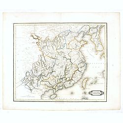
China.
Map of China, Taiwan and Korea. This map by the nephew of Aaron Arrowsmith first appeared in 1832 and was reissued several times. The present issue appeared in Arrowsmith...
Place & Date: London, 1838
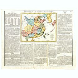
Geographical and Statistical Map of China. China and the Tributary Kingdom of Corea. For the Elucidation of Lavoisne's Genealogical, Historical, Chronological, & Geographical Atlas, by C. Gros, 1820. No. 64. Revised 1828.
Fine map of China and Korea, with a sub-title in top "Geographical and historical map of China.". The map is apparently a revised edition for 1828.The atlas was...
- $450 / ≈ €421
Place & Date: London, 1842
China.
This detailed map of China includes text giving measurements of "The Great Chinese Wall".The map was published in "Lizars' Edinburgh Geographical General A...
- $300 / ≈ €281
Place & Date: Edinburg, 1842
Chine et Japon.
Detailed map of China, Korea, Taiwan and Japan, prepared by Charles V. Monin (fl.1830-1880) a French cartographer of Caen and Paris. Published in Atlas Universel de Géog...
- $75 / ≈ €70
Place & Date: Paris, 1845
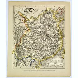
China-Propria oder das eigentliche China.
Map number 48 from Meyer's 'Zeitung's Atlas', a popular German 'pocket atlas', published during the mid nineteenth century. This map of China shows the mainland, and the ...
Place & Date: Hildburghausen / Philadelphia, 1849
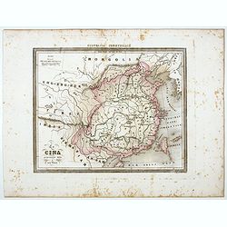
La Cina propriamente detta e sue isole.
Uncommon map of China prepared by Francesco Costantino Marmocchi. Above the map "Geografia Commerciale". From "Il Globo Atlante di carte Geografiche compil...
Place & Date: Genova, Paolo Rivara fu Giacomo, 1858
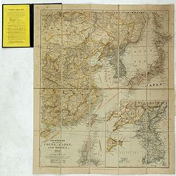
Stanford's Map of Eastern China, Japan and Korea. 1898.
Charming, folding map of the east coast of China, Korea and Japan. In the lower right corner inset map of Korea (265x512mm.). In the lower left, a key to Treaty Ports, Su...
- $750 / ≈ €702
Place & Date: London, ca. 1898
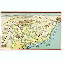
Peking. ( Pictorial map)
This pictorial map of this Game of the Goose, published at the time of the Boxer War, shows well the situation of Pei-Ho and Tientsin in relation to Peking. There are 42 ...
- $600 / ≈ €561
Place & Date: France, ca.1901