Browse Listings in Asia > Arabian Peninsular
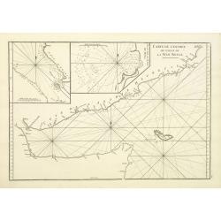
Carte de L'entrée du Golfe de la Mer Rouge.
Chart of the Gulf of Aden with the coast line of Yemen, the Island Socotra and the entrance of the Red Sea. With 2 inset charts off-shore of the town Mocha.D'Après De Ma...
- $400 / ≈ €374
Place & Date: Paris, 1753
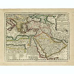
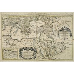
Estats de L'empire du Grand Seigneur dit Sultan et Ottomans Empereur des Turcs. . .
The map shows the extent of the Ottoman Empire from the Balkans to Persia, including all of Arabia and North Africa (an inset map at the lower left shows the continuation...
- $250 / ≈ €234
Place & Date: Paris, 1719
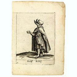
Arabs Nobilis.
Costume plate published by Pietro Bertelli in his "Diversarum nationum habitus", a sixteenth-century Italian costume book. The work was published with fold-out ...
- $70 / ≈ €66
Place & Date: Padua, 1589
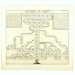
Genealogie de Mahomet.
Fine example of Chatelain's attractive plate showing the genealogy of Mahomet. Zacharie Chatelain (d.1723) was the father of Henri Abraham (1684-1743) and Zacharie Junior...
- $75 / ≈ €70
Place & Date: Amsterdam, 1714
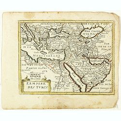
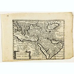
L'Empire des Turcs. (35).
Scarce map of the Turkish Empire with the Arabian Peninsula published by Antoine de Fer in 1661 or 1662 in "Cartes de géographie revues et augmentées". The se...
- $200 / ≈ €187
Place & Date: Paris, Antoine de Fer, 1657 but 1661 or 1662
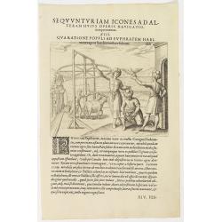
Seqvuntur Iam Icones ad Alteram Huius operis navigationem. . . (Water pump)
Illustration from seventh part of De Bry’s Petits Voyages, including Gasparo Balbi's voyage to Pegu via Syria in 1579-1588. The plate is showing a water pump driven by ...
- $100 / ≈ €94
Place & Date: Frankfurt, 1599
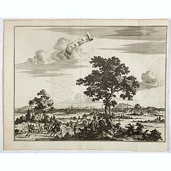
Saba, ville en Perse.
Decorative view of Saba, the main town of this kingdom in pre-Islamic southwestern Arabia. In the foreground camels and horses. This well executed engraving was published...
- $400 / ≈ €374
Place & Date: Leiden, 1719
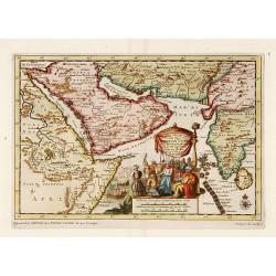
Zee-Togt van den Grooten Turk Uyt het Roode Meyr Tegen de Portugy fen na Indien tot aan Kaap Comorin Ondernomen.
Map of the Arabian peninsula, with Saudi Arabia, the Indian Ocean and India and Ceylon.Although not renowned for the originality of his work, Pieter van der Aa is highly ...
- $600 / ≈ €561
Place & Date: Leiden, 1706
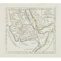
Nubie Abissinie et Cote d'Ajan.
Charming small map showing the Horn of Africa. Included are part of present-day Yemen and the coastline of Saudi Arabia along the Red Sea.From Atlas Portatif Universel, b...
- $100 / ≈ €94
Place & Date: Paris, 1749
Estats de l'empire du grand seigneurs des turcs. . .
The map represents the Ottoman Empire based on Sanson's 1654 map. The Arabian Peninsula is shown with much detail including towns, villages, mountains and watercourses an...
- $1500 / ≈ €1404
Place & Date: Amsterdam, 1692
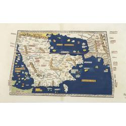
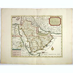
Tabula Sexta Asia (Arabian Peninsula)
This is a very desirable early Ptolemaic woodblock map of the Arabian Peninsula, here called Arabia Felix. The map is presented on a trapezoidal projection with paralle...
- $2200 / ≈ €2059
Place & Date: Strassburg, 1525
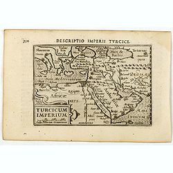
Descriptio Imperii Turcici / Turcicum Imperium.
A rare miniature map of the Arabian Peninsular. Title cartouche on the lower right corner.First published in 1598 in his Caert-Thresoor, the plates were executed by the m...
- $300 / ≈ €281
Place & Date: Amsterdam, Cornelis Claes, 1606

Carte de la Mer Rouge, depuis Moka jusqu's Gedda. . . .
Chart of the Red Sea. With 3 inset maps of Shake Omare, Goofs and Gedan. D'Après De Mannevillette (1707-1780) was one of France's first hydrographers. When the first edi...
Place & Date: Paris, 1753
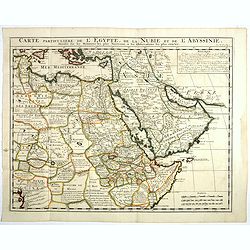
Carte Particuliere De L'Egypte, De La Nubie et de L'Abyssinie, Dressee sur les Memoires les plus Nouveaux & les Observation les plus exactes.
Including the Arabian Peninsular, Egypt, north eastern part of Africa, Cyprus and part of the Mediterranean.Based on the work of Guillaume Delisle. It is a very detailed ...
- $400 / ≈ €374
Place & Date: Amsterdam, 1728
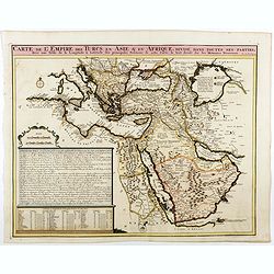
Carte de L'Empire des Turcs en Asie & en Afrique..
Including the Arabian Peninsular, Egypt, Cyprus and part of the Mediterranean.Zacharie Chatelain (d.1723) was the father of Henri Abraham (1684-1743) and Zacharie Junior ...
- $750 / ≈ €702
Place & Date: Amsterdam, 1728
(Arabian peninsula, Turkey, Irak).
A very nice map of the Arabian peninsula, Turkey and Irak. From Francisco Giustiniani for El Atlas abreviado o el nuevo compendio de la Geografia universal, politica, his...
- $150 / ≈ €140
Place & Date: Leon de Francia (Lyon), Jaime Certa, 1739

Ormus
A lovely map of miniature map the Kingdom of Ormus, published by Petrus Bertius, and published in Amsterdam at the beginning of the seventeenth century. With an attractiv...
Place & Date: Amsterdam, 1606
![[Arabian Peninsula]](/uploads/cache/33869-250x250.jpg)
[Arabian Peninsula]
Wood block printed map and one of earliest printed representation of the Arabian Peninsula prepared by Martin Waldseemüller. Based on the slightly larger map from 1513 p...
- $2200 / ≈ €2059
Place & Date: Vienna, Trechsel, G., 1525 -1541
Carte de la Coste d'Arabie, Mer Rouge, et Golfe de Perse. . .
A pleasant map of the Arabian Peninsular, the Red Sea and the Gulf region, published in Paris during the mid 18th century. Published in the "Histoire generale des V...
- $200 / ≈ €187
Place & Date: Paris, ca 1750

Accuratissima et maxima totius Turcici Imperii..
Rare issue of T. Danckert's attractive map showing the Arabian Peninsular, Turkey, Cyprus, Egypt and eastern part of the Mediterranean.Decorative title cartouche lower le...
- $1100 / ≈ €1029
Place & Date: Amsterdam, 1700

Descriptio Arabie / Arabia.
A rare miniature map of the Arabian Peninsular. The title cartouche on the lower right corner.First published in 1598 in his Caert-Thresoor, the plates were executed by t...
Place & Date: Amsterdam, Cornelis Claes, 1606
L'Empire des Turcs.
Rare map of the Turkish empire, published by Jollain in 1667. Published in "Trésor Des Cartes Geographiques Des Principaux Estats de Lunivers".Showing "&q...
Place & Date: Paris, 1667
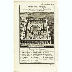
Temple de la Mecque fidelement copiée sur un dessein de la bibliothèque Bodléienne, à Oxford.
View of the Mecca Temple.
Place & Date: Pqris, ca. 1780
Nieuwe kaart van Arabia.
An attractive map of the Arabian Peninsula here called Gelukkig Arabia or Happy Arabia . The map has a great advance on other maps of the time by showing the true extent ...
Place & Date: Amsterdam, 1740

L'Arabia delineata sulle ultime osservazioni.
First edition on laid paper. Cassini’s splendid early map of Arabia.
Place & Date: Rome, 1797

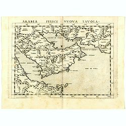
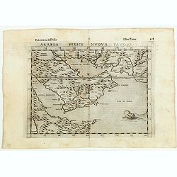
Arabia Felice Nuova Tavola.
Fine early map of Arabian peninsula, being one of the earliest modern maps of the region.Girolamo Ruscelli first published the map in his "La Geographi di Claudio To...
Place & Date: Venice, 1561
Arabia Felice Nuova Tavola.
Uncommon first edition of this modern map of Saudi Arabia, the Persian Gulf and Red Sea, for the first time it "clearly shows the island of Bahrain and Qatar".T...
Place & Date: Venice, Vincenzo Valgrisi, 1561

Carte de l'Arabie d'après les différents morceaux qu'a donnés M. Niebuh...
Detailed map of the Arabian peninsular, after Niebuhr, with scales in lower left corner. Engraved by Pierre-Paul Dubuisson.More about Mapping of Arabia [+]
Place & Date: Paris, ca. 1820

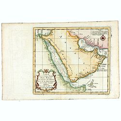
A Map and Chart of Arabia, the Red Sea, & Persian Gulf, drawn from the Chart of the Eastern Ocean, Publish'd in 1740, by Order of ye Count de Maruepas,...
A small but unusual map of the Arabian Peninsular, engraved by G. Child for 'The universal traveller: or, A compleat description of the several nations of the world', by ...
Place & Date: London, Th. Salmon, 1752-1753

Arabia
A lovely miniature map the Arabian Peninsular, published by Petrus Bertius, and published in Amsterdam at the beginning of the seventeenth century. With an attractive s...
Place & Date: Amsterdam, 1606

Carte des Principales Ports de Mer Bancs de sable &c: qui sont dans la Mer Rouge..
Some cities existed along the western coast of the Arabian peninsula, where they served as entrepots for transcontinental trade between Europe and Asia. Mecca, founded by...
Place & Date: Amsterdam, 1720

Turcici Imperii Imago.
The map shows the Ottoman Empire with Turkey, Black Sea, Mediterranean Sea, Arabia and North Eastern Africa. The map is decorated with a title cartouche and a portrait of...
Place & Date: Amsterdam, 1629

Carte des Trois Arabies. Tiree en Partie de l'Arabe de Nubie, en Partie de Divers autres Autheurs. . .
Rare map of the Arabian Peninsula, first published in 1654 and one of the first large maps focused specifically on the Arabian Peninsula. Sanson's map of the Arabian Peni...
Place & Date: Paris, 1654

Carte d'unne partie de l'Arabie Septentrionale Pour suivre les Voyages de Mr. G.A. Vallin. . .
This is the original hand-drawn map by Victor Adolphe Malte-Brun of "Carte d'unne partie de l'Arabie Septentrionale Pour suivre les Voyages de Mr. G.A. Wallin",...
Place & Date: Paris, November 1855

Arabia. Sive Regio inter Mare Medium, Arabicum Sinum, . . .
Very detailed map of the Arabian Peninsular, covering the Caspian Sea in the upper right corner and Syria to the Indian Ocean, Somalia and parts of Persia, Syria and Kurd...
Place & Date: London, 1841

Arabia.
Steel engraved map of the Arabian Peninsular. It shows Arabia and Parts of Persia, Syria and Kurdistan. The regional boundaries are colored and relief shown by hachures. ...
Place & Date: London, 1841

Karte von den Kusten von Arabien . . .
Manuscript map of Arabia. A close copy of Bellin's map of the Arabian Peninsula. In the lower right margin "Tom A, vol V."A title cartouche in the lower left co...
Place & Date: Germany, ca. 1760
![[Arabia]](/uploads/cache/40143-250x250.jpg)
[Arabia]
A lovely miniature map of the region of Armenia and Georgia, showing both parts of the Black Sea and Caspian Sea. For such a small map it renders a wealth of detail, with...
Place & Date: Ulm, 1692

Le temple de la Mecque avec une description de tout ce qu'on y voit . . .
Fascinating engraving depicting the Muslim Kaaba at Mecca. Below the main image are two smaller vignette images of people praying. In between the two vignettes is a key (...
Place & Date: Amsterdam, 1728

Mocha, in Arabien. (View of Mocha, Yemen.)
Magnificent bird's eye-town-view of Mocha in Yemen.. Etched by Gaspar Bouttats (1640-1695).The Antwerp based publisher Jacques Peeters published ca. 1690 a series of prin...
Place & Date: Antwerp, c.1690

Arabia.
A handsome map of the Arabian Peninsula drawn on a large scale on which the three classical divisions are shown with some urban centers and topographical features. A cert...
Place & Date: Amsterdam, 1662

L'illustration, journal officiel hebdomadaire.
L'Illustration, the first French illustrated newspaper from 1843, became the first magazine in the world in 1906 and is distributed in more than 150 countries.The mythica...
Place & Date: Paris, 1908

Tabula Sexta Asia (Arabian Peninsula)
This is a very desirable early Ptolemaic woodblock map of the Arabian Peninsula, here called Arabia Felix. The map is presented on a trapezoidal projection with par...
Place & Date: Vienna, 1525 -1541

L'Arabie.
Small detailed map of the Arabian Peninsula. From Atlas Portatif Universel, by Robert de Vaugondy.Page 162 outside border top right.
Place & Date: Paris, later than 1749
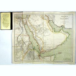
Arabia, The Red Sea, The Valley of the Nile, including Egypt, Nubia and Abyssinia.
Outstanding large, detailed map centered on the Arabian Peninsula, The Red Sea, and the North Eastern cost of Africa from Cairo to the Horn of Africa. The island of Socot...
Place & Date: London, 1903
Arabia Felice Nuova Tavola.
Fine early map of Arabian peninsula, being one of the earliest modern maps of the region.Girolamo Ruscelli first published the map in his "La Geographi di Claudio To...
Place & Date: Venice, 1598

Karte von dem groessten Theil des Landes Jemen Imame, Kaukeban &c.
Large map of Yemen from "Allgemeiner grosser Atlas" published by P. J. Schalbacher - 1786-1800. Based on the observations of the Danish explorer Carsten Niebuhr...
Place & Date: Vienna, 1789

Carte de la Coste d'Arabie.
Uncommon issue of this very nice map of the Arabian peninsula. Depicted is Saudi Arabia, Red Sea and the Persian Gulf.With French text in title cartouche and an additiona...
Place & Date: Amsterdam, 1773

Etats du Grand-Seigneur en Asie, empire de Perse, pays des Usbecs, Arabie et Egypte.
Detailed map of the region bounded by the Black Sea, Georgia, the Caspian, Uzbekistan, The Indian Ocean, Saudi Arabia (here called \"Arabie Heureuse\"), Egypt a...
Place & Date: Venise, 1778

Arabie.
Uncommon miniature map of the Arabian peninsula, from Pierre Duval's La Geographie Universeille dated 1676. Following his Cartes de géographie in 1657, Pierre Duval publ...
Place & Date: Paris, 1676