Browse Listings in America > Caribbean & Atlantic Ocean > Cuba
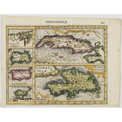
Cuba Insula. Hispaniola.
Decorative engraved map of Cuba above Hispaniola with smaller insets of Havana, Jamaica, Puerto Rico and Margarita.From the first French-text edition of Jodocus Hondius''...
- $300 / ≈ €262
Date: Amsterdam, 1608
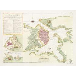
Carte Hydrographique de la Baye de la Havane.. N° 69.
A well-engraved and highly detailed chart of the walled city of Havana and its harbor features inset plans of three forts (La Punta, El Morro, and La Real Fuerza) as well...
Date: Paris, 1762

Manuscript plan of Havana harbour.
Manuscript chart with good nautical detail and soundings of Havana harbour.
Date: Spain c.1820
![Posesiones de America : Isla de Cuba. [together with] Isla de Cuba. . .](/uploads/cache/23458-250x250.jpg)
Posesiones de America : Isla de Cuba. [together with] Isla de Cuba. . .
Wall size sea chart and map of land areas showing all of Cuba, part of Florida Keys plus San Adios and Salvador Grande in the Bahamas.Minute topographical, political, and...
Date: Madrid, 1853 / 1851
