Browse Listings in Africa > Southern Africa
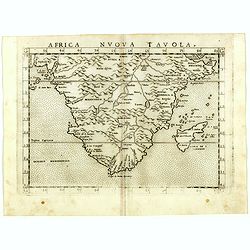
Africa nuova tavola.
Uncommon first edition of this early map of South Africa. Madagascar is called Isola de S. Lorenzo and is oddly shaped.The origin of the Nile conforms to the Ptolemaic co...
- $550 / ≈ €481
Date: Venice, Vincenzo Valgrisi, 1561
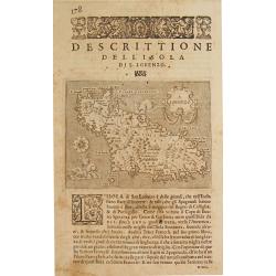
Map of Madagascar.
An old antique map of Madagascar by Tomaso Porcacchi (1530-85). L' Isole del Monde, 1572-1686. Maps engraved by Girolamo Porro. An early map of Madagascar, embellished wi...
Date: Italy, ca. 1580
![Plants found in the island of S. Laurenti [Madagascar].](/uploads/cache/41368-250x250.jpg)
Plants found in the island of S. Laurenti [Madagascar].
‘ A’ denotes a tree with only a few twigs on the top. From this tree, canoes and boats are made. ‘B’ is a bush that the Dutch frequently encountered and was called ‘leafl...
- $80 / ≈ €70
Date: Frankfurt, 1598
![[Madagascar].](/uploads/cache/37962-250x250.jpg)
[Madagascar].
Two text engravings from "Premier livre de l'histoire de la navigation aux Indes Orientales, par les hollandois, et des choses a eux advenues . . . ", being the...
- $125 / ≈ €109
Date: Amsterdam, Cornille Nicolas, 1609
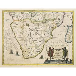
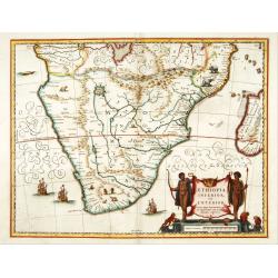
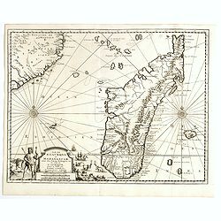
Aethiopia Inferior vel Exterior.
The standard map of South Africa throughout the 17th century. The lake out of which the 'Zambere' -the Zambesi- flows is probably based on reports of Lake Ngami, undiscov...
- $750 / ≈ €656
Date: Amsterdam, 1640
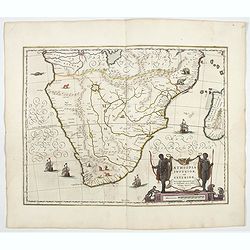
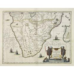
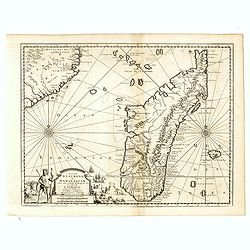
Aethiopia inferior, vel exterior.
The standard map of South Africa throughout the 17th century. The lake out of which the 'Zambere' -the Zambesi- flows is probably based on reports of Lake Ngami, undiscov...
- $1100 / ≈ €962
Date: Amsterdam, 1644
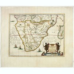
Aethiopia inferior, vel exterior.
The standard map of South Africa throughout the 17th century. The lake out of which the 'Zambere' -the Zambesi- flows is probably based on reports of Lake Ngami, undiscov...
Date: Amsterdam, 1645
Aethiopia inferior, vel exterior.
The standard map of South Africa throughout the 17th century. The lake out of which the 'Zambere' -the Zambesi- flows is probably based on reports of Lake Ngami, undiscov...
Date: Amsterdam, 1645
Aethiopia inferior, vel exterior.
The standard map of South Africa throughout the 17th century. The lake out of which the 'Zambere' -the Zambesi- flows is probably based on reports of Lake Ngami, undiscov...
- $800 / ≈ €699
Date: Amsterdam, ca. 1660
Isle D'Auphine, communement Nommée pae les Europeens Madagascar. . .
One of the most UpToDate maps of Madagascar, also showing the Comoros Islands in the North West and the Reunion Island in the South East.With decorative title cartouche r...
- $900 / ≈ €787
Date: Paris, 1667

Cimbebas et Caffariae Littora a Catenbela ad Promontorium. . .
The coast of Angola, South-West Africa and South Africa up to Port Elizabeth. Classic sea chart of Dutch school with excellent baroque embellishment. North oriented to th...
Date: Amsterdam, 1675
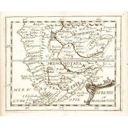
Cafrerie et Monomotapa.
Uncommon miniature map of South Africa, from Pierre Duval's "La Geographie Universeille" dated 1676. Following his Cartes de geographie in 1657, Pierre Duval pu...
Date: Paris, 1676
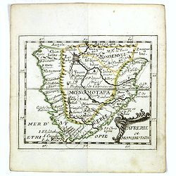
Cafrerie et Monomotapa.
Uncommon miniature map of South Africa from Pierre Duval's "La Geographie Universeille" dated 1676. Following his Cartes de geographie in 1657, Pierre Duval pub...
- $175 / ≈ €153
Date: Paris, 1676
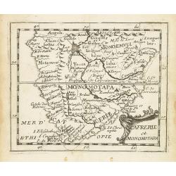
Cafrerie et Monomotapa.
Uncommon miniature map of South Africa from Pierre Duval's "La Geographie Universeille" dated 1676. Following his Cartes de géographie in 1657, Pierre Duval pub...
Date: Paris, 1676

Isola di Madagascar o di S. Lorenzo Scoperta dà Portoghesi nell anno 1506. . .
Decorative and highly detailed map of Madagascar, including 2 decorative cartouches and other embellishments.The remarkable Vincenzo Coronelli (1650-1718), was a Francisc...
Date: Venice, 1690

Insula S. Laurentii.
Miniature map of Madagascar, with four inset maps. From the French reissue of the account of early Dutch voyages first published in 1608 by Commelin. The French translati...
Date: Amsterdam, E. Roger, 1702
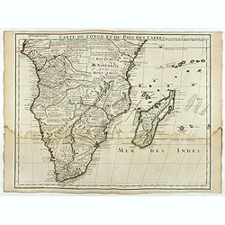
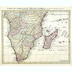
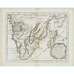
Carte du Congo et du Pays des Cafres.
Large map of the Southern part of Africa, including Madagascar. With the imprint "Chez l’Auteur sur le Quai de l’Horloge (imprint erased after Horloge) avec Privilèg...
Date: Paris, January 1708
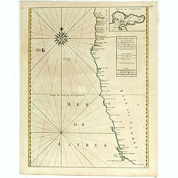
Costes de L'Afrique .. ..Cap de Bone Esperance..
In the upper right-hand corner inset map of Saldanha Bay. Numerous place names, soundings and sand banks are shown round the island and the regions are defined by origina...
Date: Amsterdam, 1720
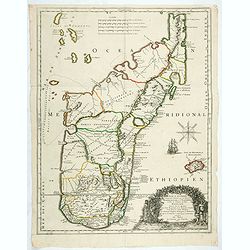
Ile de S. Laurens, ou Madagascar, située dans L'Ocean Ethiopien, sur les Côtes de L'Afrique.
Detailed map of Madagascar and Réunion. Published by Pieter van der Aa in "Galérie agréable du monde", completed in 1729. The Galerie was a sixty-six volume atl...
Date: Leiden, 1729
Ile de S. Laurens, ou Madagascar, située dans L'Ocean Ethiopien, sur les Côtes de L'Afrique.
Detailed map of Madagascar and Réunion. Published by Pieter van der Aa in "Galérie agréable du monde", completed in 1729. The Galerie was a sixty-six volume atl...
Date: Leiden, 1729
Carte du Congo et du Pays des Cafres. . .
Detailed copper-engraved map of southern Africa providing numerous particulars and comments concerning European trade, native kingdoms, and mineral wealth. Includes Madag...
Date: Amsterdam, c. 1730

Carte particulière de la côte d'Afrique depuis le cap des Courans jusqu'à la baye de Ste Hélène. . .
Large and detailed sea chart of South Africa.Engraved by Guillaume-Nicolas Delahaye (1727-1802).Latitude and longitude scales, compass rose and system of rhumb lines, sou...
Date: Paris, 1745

Plan du Cap de Bonne-Esperance et ses environs..
Large and detailed sea chart of the Cape of Good Hope from Saldahna Bay to False Bay.Engraved by Guillaume-Nicolas Delahaye (1727-1802).Latitude and longitude scales, com...
Date: Paris, 1745
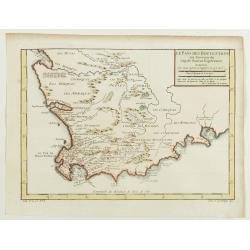
Le Pays des Hottentots aux environs du Cap de Bonne Espérance. . .
A good engraved map of Cape of Good Hope. The geographical features are typical with somewhat exaggerated bays, inlets and prominent mountain ranges. The west coast of th...
Date: Paris, 1748
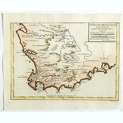
Le Pays des Hottentots . . .
Map of Good Hope Cape. Across the top is an extensive list of 22 important sites and locations keyed to the plan with tiny letters and numbers.Jacques Nicolas Bellin (170...
- $200 / ≈ €175
Date: Paris, 1750
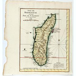
Isle de Magagascar . . .
Map of the island of Madagascar. Prepared by Jacques Nicolaas Bellin (1703-1772) who was one of the most important and proficient French cartographers of the mid-eighteen...
- $75 / ≈ €66
Date: Paris, 1750
Carte Orientale de Madacascar Depuis la Rivière Ivondrou jusqu'à Mananzari.
Large sea sea chart of the southeast coastline of Madagascar and four inset maps of the harbors and anchorage of Tamatave, Foulpointe, Teintingue und Veninguebe. Inset ma...
Date: Paris, Brest, chez Demonville, 1775
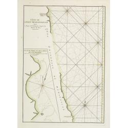
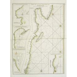
Côte de l'Isle de Madagascar depuis la Baye de Vohemare jusqu'à la pointe de l'Est. Plan du Port et de la Baye du Cap de l'Est.
French chart of the east coast of Madagascar.Latitude and longitude scales, compass rose and system of rhumb lines, soundings near coast and in bay areas.D' Après de Mann...
Date: Paris, Brest, chez Demonville, 1775
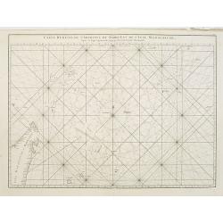
Carte réduite de l'Archipel du Nord-Est de l'Ile Madagascar.
French sea chart of an archipelago off the coast of Madagascar. The northeastern coast of Madagascar is included.Latitude and longitude scales, compass rose and system of...
Date: Paris, Brest, chez Demonville, 1775
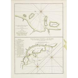
Plan des Isles Querimbo, Oybo, et Matemo / Plan de l'Ile de Patte et de son Port.
French sea chart of Isles Patte, Querimbo, Oybo, Matemo on East coast of Madagascar. Latitude and longitude scales, compass rose and system of rhumb lines, soundings near...
Date: Paris, Brest, chez Demonville, 1775
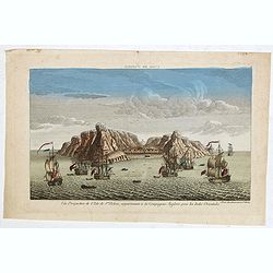
Vue perpective de l'Isle de St.Helene appartenant a la Compagnie Angloise pour les Indes Orientales.
Decorative optical view of St. Helena. The island is well-known as after the Royal Navy captured Napoleon Bonaparte, he was held hostage on the island until he died in 18...
- $300 / ≈ €262
Date: Paris, 1780
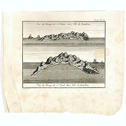
Vue du Bourg de St Denis dans l'Isle Bourbon. (together wit) Vue du Bourg de St.Paul dans l'Ile de Bourbon.
Two views from L'île de la Réunion on one plate. The upper part showing the town and harbour of St. Denis. From "Lettres Édifiantes et Curieuses. . Missionaires de l...
- $45 / ≈ €39
Date: Lyon, J. Vernarel and Et. Cabin et C., 1780/1781
Partie meridionale de l'Afrique ou se trouvent le Congo. . .
Scarce map of south of Africa with Madagascar, prepared by Nolin and published by L.J. Mondhare for his Atlas Général a l'usage des colleges et maisons d'education.. Loui...
- $200 / ≈ €175
Date: Paris, 1783
![[Map of Madagascar, Mauricius island and Réunion island, in Cyrillic ].](/uploads/cache/42567-250x250.jpg)
[Map of Madagascar, Mauricius island and Réunion island, in Cyrillic ].
A map of the south eastern coast of Africa and the island of Madagascar, comprehending 2 insets of the island of Bourbon (today Reunion) and Mauritius.The title appears i...
- $750 / ≈ €656
Date: Paris / St.Petersburg, ca. 1790
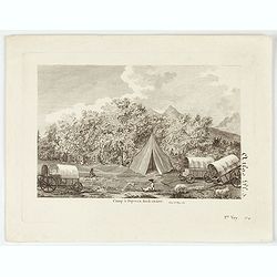
Camp à Duywen Hock Riviere. (Tom.1er. Pag.131.)
Camp Duywen Hock River engraved view, from Francois Levaillant’s Voyage dans l’interieur de l’Afrique. Text in French reads “Tom. 1er. Pag. 131. Atlas pl. 5. 1er Voy., no...
- $250 / ≈ €219
Date: Paris, 1798
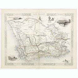
Cape Colony.
A decorative steel engraved map from the famous Victorian publisher John Tallis and Company, published ca.1851. Drawn and engraved by J Rapkin, while the four corner vign...
Date: London, Edinburgh, Dublin, 1851
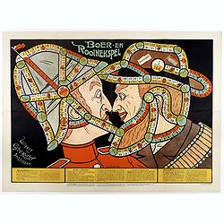
Boer-en Rooinekspel.
Design by E.G.Schlette. This is a board game similar to the famous "snakes and lessons". The game takes the players through various historical battles. Success ...
- $600 / ≈ €525
Date: Amsterdam, Koster, ca. 1890
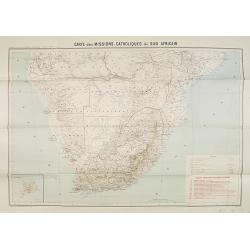
Carte des Missions Catholiques du Sud Africain.
Map of the Catholic Missions in South Africa. Inset map of L'Ile St. Hélène.Published as supplement of the Les Missions Catholiques. To the lower right an inset key to th...
Date: Paris, Monrocq, 1902
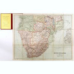
British South Africa.
With the signature of Alan Sillitoe (1928-2010), who was England’s best writer of proletarian fiction. From an early age, geography and maps were a very important part of...
- $450 / ≈ €393
Date: London, 1923
