Browse Listings

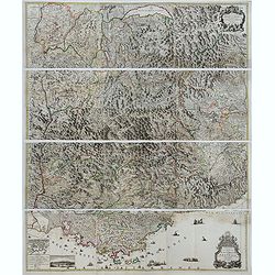
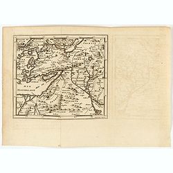
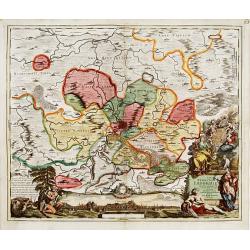
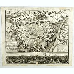
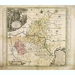
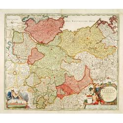
Potentissimo Borussorum Regi Friderico Wilhelmo Maiestate, Fortitudine Clementia Augustissimo Hancce Lithuaniam Borussicam : in qua luca coloniis Salisburg., ad incolendum Regio nutu...
Potentissimo Borussorum Regi Friderico Wilhelmo Maiestate, Fortitudine Clementia Augustissimo Hancce Lithuaniam Borussicam : in qua luca coloniis Salisburg., ad incolendu...
Date: Nuremberg, 1735
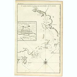
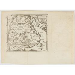
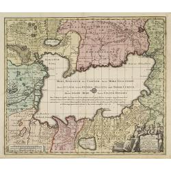
Carte particulière de l'entrée de Canton - Plan de Quang-tcheou-fou vulgo Canton .
Beautiful detailed map of the entrance to the city of Canton, showing also the cities of Macao and Quanghai, as well as the islands of the bay, including the island of Sh...
- $450 / ≈ €388
Date: Paris, P.G. Le Mercier, 1735
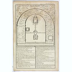
Plan du Tien-tang ou du temple, où l'empereur sacrifie à Chang-ti sous le titre de souverain seigneur de la terre.
Nice example of d'Anville's plan of Tien-tang temple, from "Atlas général de la Chine..."" prepared by Jesuit missionaries and commissioned by Emperor Ka...
Date: Paris, P.G. Le Mercier, 1735
Potentissimo Borussorum Regi Friderico Wilhelmo Maiestate, Fortitudine Clementia Augustissimo Hancce Lithuaniam Borussicam : in qua luca coloniis Salisburg., ad incolendum Regio nutu concessa ...
Potentissimo Borussorum Regi Friderico Wilhelmo Maiestate, Fortitudine Clementia Augustissimo Hancce Lithuaniam Borussicam : in qua luca coloniis Salisburg., ad incolendu...
- $1500 / ≈ €1295
Date: Nuremberg, 1735
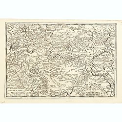
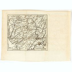
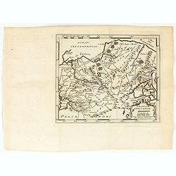
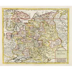
Nieuwe kaart van Muskovien door M. de l'Isle.
This lovely little map of the area surrounding Moscow is based on Delisle's map of the region. The map is bounded by Lake Ilmen in the north, the Volga River to the east,...
- $100 / ≈ €86
Date: Amsterdam, 1735
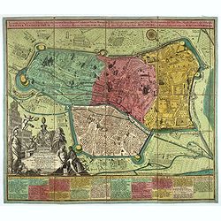
Theatre de la Guerre en Savoie et en Piémont - Le Dauphiné, La Bresse - Partie du Lionnois et de la Provence./ Theatre de la guerre en Dauphiné et en Provence…
Rare wall map of the Savoie/Piémont and Dauphiné/Provence region. Decorated with 2 title-cartouches, one at upper right part (Savoye/Piémont) and one at lower right pr...
- $3000 / ≈ €2590
Date: Amsterdam, c.1735
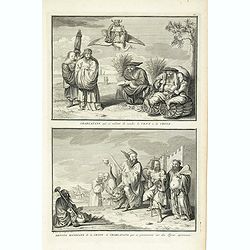
Charlatans qui se mêlent de vendre le vent de la Chine. Dévots mendiants de la Chine et charlatans qui se promènent sur des tigres apprivoisés, . . .
Two fascinating engraving on one sheet depicting Chinese charlatans. Engraved by Bernard Picart. Published in Jean Frederic Bernard's monumental "Cérémonies et cou...
- $150 / ≈ €129
Date: Amsterdam, J.F. Bernard c.1736
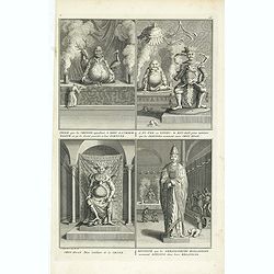
Idole que les chinois appellant, le dieu de l´immortalité, et qu´ils disent presider a leur Fortune. . .
Four fascinating engraving on one sheet depicting Chinese gods. "Idole que les chinois appellant, le dieu de l´immortalité, et qu´ils disent presider a leur Fortu...
- $150 / ≈ €129
Date: Amsterdam, J.F. Bernard c.1736

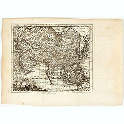
Asia By H.Moll Geographer.
Detailed map of Asia. From his "Atlas minor: or a new and curious set of sixty-two maps. . .", which was first published in 1729 and reprinted in 1732, 1736.The...
Date: London, 1736

Description geographique, historique, chronologique, politique, et physique de l'empire de la Chine et de la Tartarie chinoise . . . du Thibet, & de la Coree. . .
Without the separately published atlas. Lacking 2 plates in vol.2 (Obseques at p.149 and Gin seng at p.180), one plate torn without a loss (vol.1, p.230), d4 vol.1 with a...
Date: The Hague, H. Scheurleer, 1736

Urbium Londini et West-Monasterii nec non Surburbii Southwark Accurata Ichnographia ,., Neuester Grundris der Staedte London und West-Munster, Samt der Vorstadt Southwark ,.,
Detailed plan of London, extending from Grosvenor Square in the west to Mile End to the east, To the right inset views of St, James's Square, and Custom House, elevations...
Date: Nuremberg, 1736
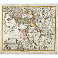
Imperium Turcicum in Europa, Asia et Africa Regiones proprias, tributarias, clientelares sicut et omnes eusdem Beglirbegatus seu Præfecturas Generales exhibens. . .
Johann Baptist Homann's well-engraved map of the Ottoman Empire centered on Cyprus. With good detail in the Arabian Peninsular. In the lower left, a decorative title cart...
- $500 / ≈ €432
Date: Nurnberg, 1737
![Province de Fo-Kien. [Includes West Coast of Taiwan]](/uploads/cache/43503-250x250.jpg)
Province de Fo-Kien. [Includes West Coast of Taiwan]
An important map of Fujian Province shows the East Coast of China and the West Coast of Taiwan. It shows that for the Manchu Qing, only the western half of Formosa was co...
Date: The Hague, H. Scheurleer, 1737
![[Title page] Atlas Novus Terrarum Orbis Imperia. . .](/uploads/cache/49113-250x250.jpg)
[Title page] Atlas Novus Terrarum Orbis Imperia. . .
The lovely title page from Homann's Grosser Atlas uber de Gantsa Welt (Grand Atlas of all the World)with striking color and features. It shows Atlas and Hercules / Herakl...
Date: Nuremberg, ca 1737
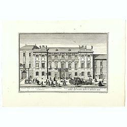
Prospectus Palatÿ Comitis Leopoldi de Windischgräz . . .
Very nice engraving by J.A. Corvinus after a design of Salomon Kleiner showing the house of an Austrian aristocratic family.
- $100 / ≈ €86
Date: Augsburg, 1737
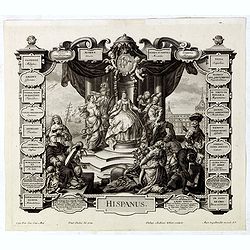
Hispanus.
Allegorical print of Spain (Hispanus), copper engraving after P. Decker by M. Engelbrecht. Taken from "Laconicum Europae Speculum". Philippe Andrea Kilian (1714...
Date: Augsburg, 1737
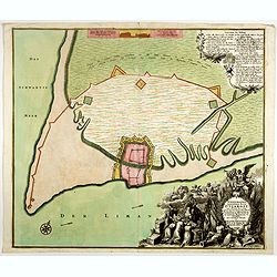
Ichnographia munitissimae Arcis Otzakoff quae Ao. 1737, die 3 Iulÿ auspicÿs Supremi Campi Mareschalli Comitis de Münnich ab exercitu Russorum vi occupata . . .
A striking image of this fortified Russian outpost on the Black Sea at Otzakoff, northeast of Odessa.
- $1100 / ≈ €950
Date: Augsburg, 1737

A Map of the British Empire in AMERICA with the French, Spanish and Hollandish Settlements Adjacent Thereto. by Henry Popple. / Nouvelle Carte Particuliere de L'Amerique . . .
The four sheet Dutch edition of Popple's monumental map of North America, in mint condition. Encompassing the West Indies, Florida, Louisiana, Texas and Central America.T...
Date: Amsterdam, ca. 1737
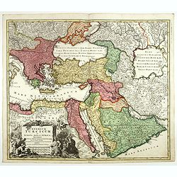
Imperium Turcicum in Europa, Asia et Africa.
Johann Baptist Homann's well-engraved map of the Turkish Empire, showing from Tunis to Arabia, including Greece, Arabia, Turkey and Palestine. With good detail in the Ara...
- $1000 / ≈ €863
Date: Nurnberg, 1737

Nouvel atlas de la Chine, de la Tartarie chinoise, et du Thibet.
First edition of "the principal cartographic authority on China during the 18th century". It was the second major atlas of China produced in Europe following th...
Date: The Hague, H. Scheurleer, 1737
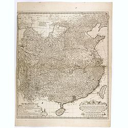
Carte générale de la Chine Dressée sur les Cartes particulières que l'Empereur Cang-hi a fait lever sur les lieux par les RR. PP. Jésuites missionaires dans cet empire / Par le Sr d'Anville.
An essential and very detailed map of the Southern part of China, including a detailed map of Taiwan.Jean Baptiste Bourguignon d' Anville (1697-1782) was a French cartogr...
Date: The Hague, H. Scheurleer, 1737

Carte la plus generale et qui comprend la Chine, la Tartarie chinoise et le Thibet. . .
It has a quite elaborate pictorial cartouche engraved by G. Kondet. It is a very detailed map of China, Tibet, and Korea.In the upper left corner is very good details of ...
Date: The Hague, 1737

Kaerte en Afbeeldinge vande Geheele Jurisdictie van Stantdarbuyten Gelegen in de Generaliteit onder Marquisaet van Bergen op den Zoom
With a large title cartouche with signature of the maker Adriaan van der Ende, : Kaerte en Afbeeldinge vande Geheele Jurisdictie van Stantdarbuyten Gelegen in de Generali...
Date: Willemstad, 1737

Picardie Meridionale Le Cambresis et leurs Environs.
Map showing the region of Picardie in Northern France. Including the towns of Abbeville, Amiens, Compiegne, Soisson, Chambray, etc.
Date: Paris, 1737

Royaume de Corée.
With a quite elaborately pictorial cartouche, engraved by G.Kondet. One of the earliest separate maps of Korea. Jean Baptiste Bourguignon d' Anville (1697-1782), French c...
Date: The Hague, 1737

Avantures du Sr. C. Le Beau, avocat en parlement ou Voyage curieux et nouveau parmi les Sauvages de l'Amérique Septentrionale. Dans lequel on trouvera une Description du Canada… Ouvrage enrichi d'une Carte et des figures necessaires.
A description of Huron, Iroquois, and Algonquin customs, written in charming style and based, the Author claims, on observations made on a trip to America in 1729." ...
Date: Amsterdam, 1738

Ein Formosaner. (Inhabitant of Formosa / Taiwan)
Wood cut with letter press, showing an inhabitant of Formosa (Taiwan) by Jacob Martini, published in "Neu-eingerichtete und vermehrte Bilder-Geographie …", pu...
Date: Erfurt, ca. 1738
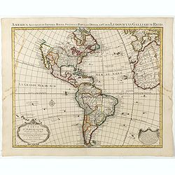
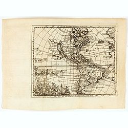
Carte d'Amerique dressée par l'usage du Roy..
Fine map prepared by G.d'Isle depicting North and south America, the west coast taken north to Cap Mendocin and Cap Blanc with a note Entrée decouverte par Martin d'Agui...
Date: Amsterdam, 1739
![(Chatelain "Atlas Historique" in 7 volumes.]](/uploads/cache/47053X-250x250.jpg)
(Chatelain "Atlas Historique" in 7 volumes.]
Henri Abraham Chatelain, whose Atlas Historique was one of the most expansive encyclopedias of the age. First published in 1705, Chatelain's Atlas Historique was part o...
Date: Amsterdam: Chez Zacharie Châtelain, 1732 - 1739
La Chine.
A very nice map of China, including Korea and Taiwan. From Francisco Giustiniani for El Atlas abreviado o el nuevo compendio de la Geografia universal, politica, historic...
- $300 / ≈ €259
Date: Leon de Francia (Lyon), Jaime Certa, 1739
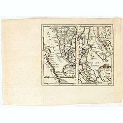
Presqu'Isle de l'inde deça le Golfe du Gange/Presqu'Isle de l'Inde dela le Golfe du Gange.
Two maps on one sheet, one depicting India, Sri Lanka and the Maldives Islands (13,5 x 8 cm) and the otherone Cambodia, Thailand, Singapore and Malaysia (13,5 x 8 cm). F...
- $300 / ≈ €259
Date: Leon de Francia (Lyon), Jaime Certa, 1739
Asiae.
A very nice map of Asia. From Francisco Giustiniani for El Atlas abreviado o el nuevo compendio de la Geografia universal, politica, historica, i curiosa, segun el estado...
- $300 / ≈ €259
Date: Leon de Francia (Lyon), Jaime Certa, 1739
Mogol.
A very nice map of Northern India and Pakistan. From Francisco Giustiniani for El Atlas abreviado o el nuevo compendio de la Geografia universal, politica, historica, i c...
- $150 / ≈ €129
Date: Leon de Francia (Lyon), Jaime Certa, 1739

'T Eilandje Desima verblyf plaats der Hollanders in Japan.
Bird's-eye view of Dejima copied from a manuscript by Voogt, who was second-in-command on Deshima in 1713. The island is viewed from the landside, depicting the developme...
Date: Amsterdam, 1739
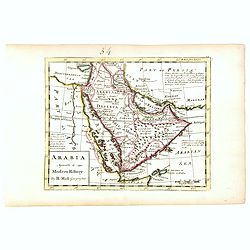
Arabia agreeable to Modern History.
Detailed map of the Arabian Peninsula from the Mediterranean Sea to the Arabian Sea, and western Iran. with an engaging text block on upper right corner: "Arabia, d...
- $550 / ≈ €475
Date: London, 1739
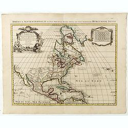
L'Amerique septentrionale, Dressée sur les memoires les plus recens. . .
A very detailed map extending from Hudsons Bay to Panama, and including the West Indies. The map is a later copy of Guillaume de L'Isle's foundation map of North America,...
Date: Amsterdam, 1739
(Arabian peninsula, Turkey, Irak).
A very nice map of the Arabian peninsula, Turkey and Irak. From Francisco Giustiniani for El Atlas abreviado o el nuevo compendio de la Geografia universal, politica, his...
- $150 / ≈ €129
Date: Leon de Francia (Lyon), Jaime Certa, 1739
America.
A very nice map of the American continent with California as an island and an adorned title cartouche.From Francisco Giustiniani for El Atlas abreviado o el nuevo compend...
- $300 / ≈ €259
Date: Leon de Francia (Lyon), Jaime Certa, 1739

Plan de Paris commencé l'année 1734, Dessiné et gravé sous les ordres de Messire Michel Etienne Turgot, prévost des marchands.
FIRST EDITION of Turgot's Monumental Joined View of Paris, stretching to over 10 Feet. This expansive large-scale engraved view of Paris covers the first eleven arrondis...
Date: Paris, 1739
Grande Tartarie.
A very nice map of Tartaria extending from the Caspian Sea to the Pacific Ocean. From Francisco Giustiniani for El Atlas abreviado o el nuevo compendio de la Geografia un...
- $150 / ≈ €129
Date: Leon de Francia (Lyon), Jaime Certa, 1739
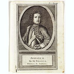
Augusti. II. Re di Polonia, Ellettore di Sassonia.
Portrait of Augustus II the Strong (12 May 1670 – 1 February 1733) of the Albertine line of the House of Wettin was Elector of Saxony (as Frederick Augustus I), Imperia...
Date: Venice, 1739
Perse.
A very nice map of Persia. From Francisco Giustiniani for El Atlas abreviado o el nuevo compendio de la Geografia universal, politica, historica, i curiosa, segun el esta...
- $150 / ≈ €129
Date: Leon de Francia (Lyon), Jaime Certa, 1739
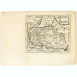
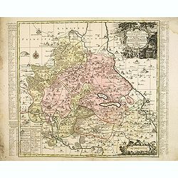
Imperii Russici et Tartariae Universae tam majoris Afiaticæ quam minoris et EuropæTabula.
The map is of interest for the use of East Sea, the sea between Korea and Japan, here called "Mere Orientale Minus".Decorative map covering Russia, Tibet, China...
Date: Nuremberg, 1739

Carte des Isles de Maiorque Minorque et Yvice dediée A.M. le Comte de Maurepas Ministre et secretaire d'Etat. . .
Fine map of the Baleares with much detail, in lower part inset "Plan du Port de Mahon du Fort St. Philippe et ses Fortifications". The map is dedicated to Jean ...
Date: Amsterdam, after 1740
Gemete Kaerte van de Stede Beverwyk, zoo als die tegenwoordigh zich vertoont.
Uncommon plan of Beverwijk made in the year 1739. Published in Hollandsche Arcadia. Title in Dutch and French.
Date: Amsterdam, ca.1740
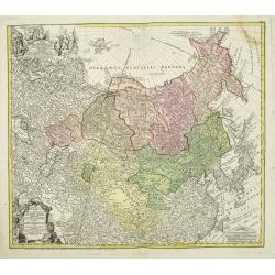
Moscoviae seu Russiae Magnae Generalis Tabula. . .
A scarce and attractive, wide-ranging map of incorporating Scandinavia, the Baltic countries, parts of Germany and Czechoslovakia, Poland, Hungary, Ukraine, Bulgaria, Nor...
- $1500 / ≈ €1295
Date: Augsburg, 1740
Nova Territorii Erfordien in suas praefecturas..
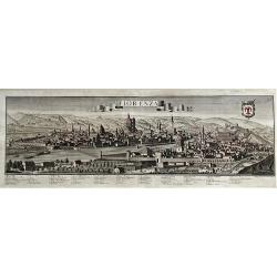
"Showing the area of Erfurt. In the lower part, there is a panoramic view of the town. Lower left and right splendid cartouches.The cartouches are painted in a stron...
Date: Nurenberg, 1740
![[Title page] Atlante Novissimo . . .](/uploads/cache/48001-250x250.jpg)
[Title page] Atlante Novissimo . . .
Uncommon frontispiece, From Girolamo Albizzi, Italian version of Guillaume Delisle atlas"Atlante novissimo . . ."The architectural columns are flanked by both ...
- $225 / ≈ €194
Date: Venice, 1740

Carte de L\'Egypte de la Nubie de L\'Abissinie. . .
Prepared by G.de l'Isle. Uncommon issue by Hendrik de Leth. Very detailed map of northeastern Africa, the Red Sea and the Arabian peninsula shows the political divisions ...
Date: Amsterdam, 1740
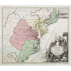
Virginia Marylandia et Carolina..
An attractive and detailed map, covering the coastline from Long Island in the north to just south of Cape Feare in Carolina, with the large fictitious Apalache Lacus in ...
- $1500 / ≈ €1295
Date: Augsburg, 1740
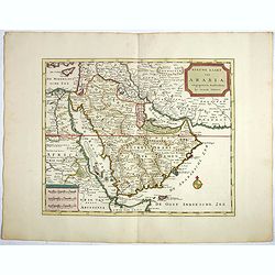
Nieuwe kaart van Arabia.
Here is an attractive map of the Arabian Peninsula, Gelukkig Arabia or Happy Arabia. The map is a great advance on other maps of the time by showing the true extent of...
Date: Amsterdam, 1740
![[Portrait] Johannes Baptista Homann . . .](/uploads/cache/44363-250x250.jpg)
[Portrait] Johannes Baptista Homann . . .
Stunning full portrait of the Imperial Geographer of the Holy Roman Empire, Johann Baptist Homann (1664-1724) who was born in the Bavarian town of Kammlach. Educated at a...
Date: Nuremberg, c.1740
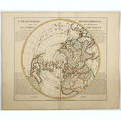
l'Hemisphere Septentrionale pour voir plus distinctement Les Terres Arctiques. . .
This is a stunning and terrific map of the Northern Hemisphere that was originally drawn by Guillaume de L'Isle in 1714 and updated by Coven's and Mortier in 1741. It cov...
Date: Amsterdam 1740
![[Portrait] - Me De Cet Corona se X+I. - Contantia et Fortudine](/uploads/cache/43510-250x250.jpg)
[Portrait] - Me De Cet Corona se X+I. - Contantia et Fortudine
Portrait of German Emperor Charles VI with his motto "Contantia et Fortudine". Holy Roman Emperor, 1711-1740, and King of Hungary as Charles III (1712-1740). Wi...
Date: Germany, 1740
Dantiscum F. Gedanum celeberrimum . . .
Dantzig city plan with a bird-eye view of the city and the main monuments.Matthaus Seutter the elder first published his "Atlas Geographicus" in 1720 and added ...
Date: Augsburg, ca. 1740
Accurata recens delineata ichnographia celeberrimæ liberæ Imperii civitatis ac Sueviæ metropolis Agustæ Vindelicorum -Neu verfertigt accurater ... Haupt Stadt Augspurg.
Superb plan of the fortified town of Augsburg, brilliantly colored at the time, with title in Latin and German. The plan was designed by Johann Thomas Kraus, engraver, ar...
- $1200 / ≈ €1036
Date: Nuremberg, ca. 1740
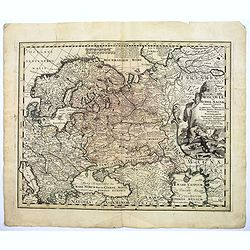
Moscovia o Russia.
Map showing European Russia and is centered on Moscow. In the lower right corner, title cartouche with scale and the town of Astrakhan. From "Atlante Novissimo Che C...
Date: Venice, 1740

Bern in der Schweitz.
Very fine large-scale panoramic view of Bern. With a numbered key (1-25) of principal buildings in town. ¤
Date: Augsburg, 1740

Dominia Anglorum in America Septentrionali.
Four maps on one sheet (New Found land/ New England/ Virginia and Carolina/Florida) based on J.B.Homann's map, showing British possessions in North America. The upper lef...
- $750 / ≈ €647
Date: Nuremberg 1740
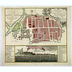
Grund=Riss und Prospect der Koniglichen Danischen auf der Kuste Choromandel in Ost-Indien belegenen Vestung und Stadt Dansburg u Trankenbar . . .
The Danish East India Company was founded in 1616. A first expedition was sent out in November 1618, which led to the purchase of a parcel of land on the Coromandel coast...
Date: Augsburg ca 1740
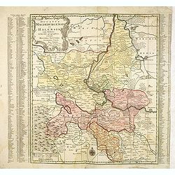
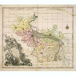
Ducatus Magdeburgensis Et Halensis cum finitimis Delineatio geographica. . .
Very decorative map centered on Magdeburg with Elbe river. With a key to the left and right of the map.
- $75 / ≈ €65
Date: Augsburg, ca. 1740
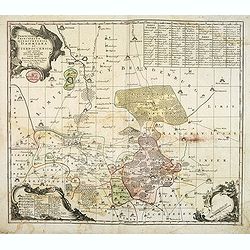
Mappae Imperii Moscovitici pars Septentrionalis..
Detailed map of northern Russia embellished with an uncolored pictorial cartouche showing hunting scenes.Prepared by de l'Isle.
Date: Augsburg, 1740
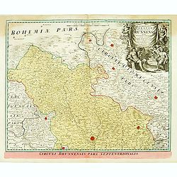
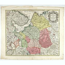
Marchionatus Moraviae circulus brunnensis. . .
Johann Baptist Homann's well-engraved map has a large decorative cartouche. Detailed map centered on Bruenn in Moravia. Prepared by Johann Chr. Mueller. Very decorative t...
- $300 / ≈ €259
Date: Nuremberg, 1740
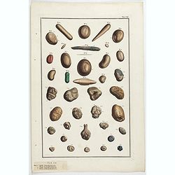
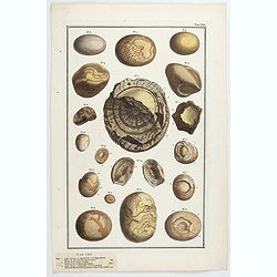
Lapides Bezoardici Orientales. Tab CXI.
Natural history aroused the passion of wealthy collectors in the 17th and 18th centuries. These constitute vast "cabinets of curiosities" and sometimes undertak...
- $90 / ≈ €78
Date: Amsterdam, ca 1740
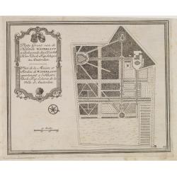
Platte Gront van de Hofstede Waterlant toebehorende den Ed. Achtb. Heer Dirk Trip Schepen te Amsterdam.
Uncommon plan of Hofstede Waterlant. Published in Hollandsche Arcadia. Title in Dutch and French "Plan de la Maison et Jardins appartenant a l'Illustre Dirk Trip Ech...
Date: Amsterdam, 1740
![[Lot of 5 maps of the mouth of the Gironde river] Carte des Entrees et Cours de la Gironde](/uploads/cache/86010-250x250.jpg)
[Lot of 5 maps of the mouth of the Gironde river] Carte des Entrees et Cours de la Gironde
A large sea chart of the mouth and course of the Gironde river as far inland as Bordeaux. Decorated with three cartouches.Jacques Nicolas Bellin (1702-720) was the most i...
- $350 / ≈ €302
Date: Paris, c. 1740
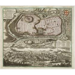
Prospectus Sanctae olim.. Hierosolymae.. Jerusalem. . .
Two bird's eye perspectives views of Jerusalem. Each with an extensive numbered key to principal buildings in town. Title in Latin and German. The print is published by M...
Date: Augsburg, 1740
Praefecturae Principatus Querfurtensis Dahmiana et Iüterboccensis cum vicinia oppidis, vicis, pagis accurate distincta. . .
Showing the region of Ämter Dahme, Jüterbog, Baruth. With in the north Potsdam and in the south Schönwalde, in the west Brück/ Zahna and in the east Buchholz/ Luckau.
- $50 / ≈ €43
Date: Augsburg, ca. 1740
Delineatio Geographica Ditionis Martisburgensis hodie regiis et electoralibus auspiciis florentis edita. . .
Map shows the surrounding of the city of Halle. With a very large title cartouche occupying the lower left corner. Engraved by Tobias Conrad Lotter.
- $75 / ≈ €65
Date: Augsburg, 1740
Delineatio geographica praefecturarum Wittebergensis, et Graefenhaynichen. . .
Showing Amt Wittenberge with the river Elbe. Wittenberge is a town of eighteen thousand people on the middle Elbe in the district of Prignitz, Brandenburg.
- $75 / ≈ €65
Date: Augsburg, 1740
Delineatio geographica praefecturarum Wittebergensis et Graefenhaynichen; in circulo electorali sitarum. . .
Very decorative map of Mansfeld Land, a region in the southwestern corner of the German state of Saxony-Anhalt. The region derives its name from the counts of Mansfeld, w...
- $75 / ≈ €65
Date: Augsburg, ca. 1740
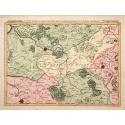
Carte particuliere des environs de Fauquemont et Aix la Chapelle.
An attractive map of the southern part of Limburg, centered on Valkenburg, Aachen, Rolduc and Dalem.
Date: Paris, 1740
Nova et accuratissima Maris Caspii. . .
Original hand colored copper engraving of Matthaeus Seutter. Showing the Caspian Sea with the large Volga Delta in east orientation. Main towns / countries around the Cas...
- $750 / ≈ €647
Date: Augsburg, 1740
Fiorenza.
A spectacular largescale panoramic view of Florence taken from Montoliveto, with legends numbered from 1- 63 in Italian. With the title in a banderol. After a design by F...
Date: Augsburg, ca 1740
Circulus Saxoniae inferioris.
Detailed map of Saxen, including Bremen, Berlin, Lübeck, etc. Johann Baptist Homann (1663-1724) was a German engraver and publisher, who established himself and his fami...
- $200 / ≈ €173
Date: Nuremberg 1740
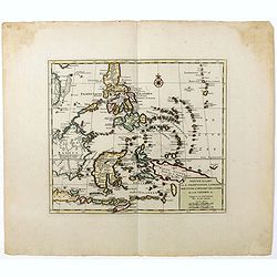
Nieuwe kaart van de Filippynsche, Ladrones, Moluccos of Specery Eilanden als mede Celebes etc.
Shows the western islands of the archipelago, Borneo, Java and Sumatra, up to and including New Guinea. With very good detail to Philippines.Read more Early maps of South...
Date: Amsterdam, 1740
Lapides Bezoar ex Hippototamo, vel Equo marino. Tab CXII.
Natural history aroused the passion of wealthy collectors in the 17th and 18th centuries. These constitute vast "cabinets of curiosities" and sometimes undertak...
- $90 / ≈ €78
Date: Amsterdam, ca 1740
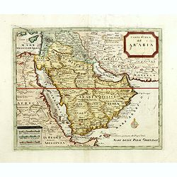
Carta nuova dell'Arabia.
Detailed map of Arabia and environs. Based on a map published by Isaak Tirion in Amsterdam, but here issued by Albrizzi with a modified title.More about Mapping of Arabia...
Date: Venice, 1740

Carte de L'Egypte de la Nubie de L'Abissinie..
Prepared by G.de l'Isle. Uncommon issue by Hendrik de Leth. Very detailed map of northeastern Africa, the Red Sea and the Arabian peninsula shows the political divisions ...
- $500 / ≈ €432
Date: Amsterdam 1740
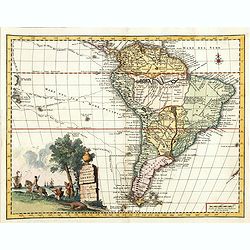
Carta geografica della america meridionale.
Uncommon map of South America based upon Guillaume De L'Isle's map. Includes the routes of early explorers in the Pacific, including Magellan, Drake, Le Maire, Mendana, V...
Date: Venice, 1740