Browse Listings
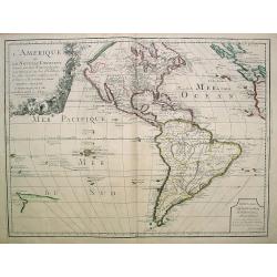
L'Amerique ou le Nouvelle Continent.. Dedieé et presenteé a monseigneur Law.
State one. The map has been prepared by Jean Baptiste Nolin (the elder) has a dedication to Monseigneur LAW controlleur general des finances .Rare general map of the Amer...
- $2200 / ≈ €1899
Date: Paris, 1720
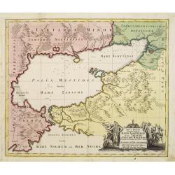
Maris Assoviensis vel de Zabache et Paludis Maeotidis. . .
A very detailed map showing the Black Sea, Azow and Rostow area.
Date: Augsburg, 1720
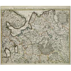
Carte de Moscovie. . .
Centred on Moscow, including Lapland. With fine uncolored title cartouche.
Date: Amsterdam, 1720
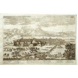
![Mayence Mentz en allemand .. [Metz]](/uploads/cache/13109-250x250.jpg)
Mayence Mentz en allemand .. [Metz]
A very RARE panoramic view of the city of Metz, including a numbered legend in the lower corners. The plate is numbered in red pencil in the upper right corner.Engraved b...
- $200 / ≈ €173
Date: Paris 1690-1720

Norimberga.
A spectacular panoramic town-view of Nuremberg, with legends numbered from 1-39 in German. With the title in a banderol.After a design by Friedrich Bernhard Werner (1690...
Date: Augsburg, ca. 1720

Riga metropolis Livoniae.
A spectacular panoramic view of Riga, with legends numbered from a-z and 1-16 in German. With the title in a banderol.After a design by Friedrich Bernhard Werner (1690-1...
Date: Augsburg, ca. 1720
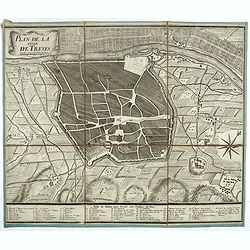
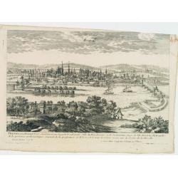
Plan de la ville de Treves.
Very rare town-plan of Trier by Didier Bugnon (1676-1736), geographer of the Duke of Lorraine. With numbered key (1-57) of the main buildings and buildings of the city. T...
Date: Paris?, 1720
Namur.
A very RARE panoramic of the city of Namur, with a numbered legend in both lower corners.The plate is numbered in red pencil in upper right corner.Engraved by Pierre Avel...
- $150 / ≈ €129
Date: Paris, 1690-1720
Nova ac verissima Maris Caspii ante hac maximam fere partem nobis incogniti, ac Regionum adiacentium : Delineatio Iussu Invictissimi Principis Petri Alexii Fil. Magni Russorum Imperatoris / immenso labore et maximis sumptibus facta, atque ex ...
Covers portions of Iran, Turkmenistan, Kazakhstan, Russia and Azerbaijan. Relief is shown pictorially. Depth is shown by soundings. Oriented with north to the left. Rare.
- $750 / ≈ €647
Date: Amsterdam, 1720
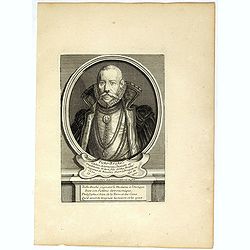
Ticho-Braché . . .
Uncommon portrait of Tycho Brahe, (1546 - 1601) engraved and published by Étienne Jehandier Desrochers ( Lyon 1668 - Paris 1741). Brahe was a Danish astronomer whose wor...
- $150 / ≈ €129
Date: Paris, 1720
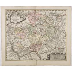
Nassovia Principatus Cum omnibus ei pertinentibus Comitatibus Dominiis ac Praefecturis ut et Confiniis intra Lahnun, Rhenum, et Moenum Flumina, ad situm verum exacte delineatus a Joh. Jac. Stetter. U.J.L. Idstenio-Nassovio . . .
Decorative map of the area between the rivers Rhine and Meuse, including Mainz, Koblenz, Frankfurt, Saarbrucken, etc.Includes an elaborate cartouche and coat of arms.The ...
- $150 / ≈ €129
Date: Amsterdam, 1720
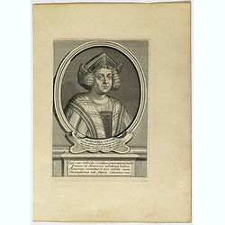
Christophe Colomb . . .
Fine portrait of Christopher Columbus (c.?1451 – 1506) engraved and published by Étienne Jehandier Desrochers ( Lyon 1668 - Paris 1741).Christopher Columbus was an Ita...
- $75 / ≈ €65
Date: Paris, 1720
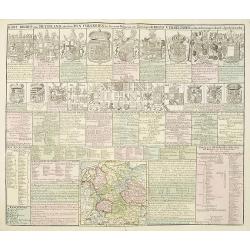
Kort Begryp van Duytsland, de drie Ryx Collegien in hunne Wapens en Zittingen. Kreits Verelingen en Aantekenigen door C. Specht't Utrectht.
Second state of this decorative table of family escutcheons, crests and coats of arms, for various German and Dutch princes and nobles of the 16th, 17th and 18th Centurie...
Date: Amsterdam, 1720

A new map of the English Empire in America. . .
This fine English map of eastern North America including Canada engraved by John Harris and first published by Robert Morden. John Senex acquired and made minor alteratio...
Date: London, 1720

Huquang, Kiangsi, Chekiang ac Fokien.
A reissue of Janssonius' map of south east China, with wash color and uncolored cartouches.The map is based on the maps of Martin Martini, themselves based on Chinese sou...
Date: Amsterdam, 1720
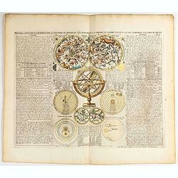
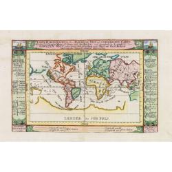
Premiere carte pour l'Introduction a l'histoire du monde, ou l'on remarque la Sphere, le Globe Celeste. . .
Featuring a small double hemisphere world map, showing California as an island, North and South Polar celestial hemispheres, an Armillary Sphere, below with smaller circu...
- $500 / ≈ €432
Date: Amsterdam, 1720
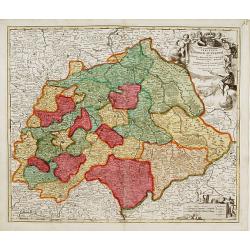
Saxoniae Superioris
Impressive title cartouche with miniature panoramic view of Leipzig, coat of arms, putti and Mercury.Johann Baptist Homann born in Kammlach (1663). He was engraver, map-s...
- $150 / ≈ €129
Date: Augsburg, 1720
![[Title page] Gli Argonauti.](/uploads/cache/23338-250x250.jpg)
[Title page] Gli Argonauti.
Decorative title page illustrating allegorical and mythological figures. Engraved by Alessandro Dalla Via after a drawing by Lodovico Lanberti.At the top some cherubs car...
Date: Venice, ca. 1720
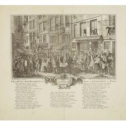
Rue Quinquempoix en l'année 1720. De regte afbeelding der wind negotie gehouden in de straat van Quinquempoix tot Parys.
A true picture of the wind trade of the rue Quinquempoix, Paris, in 1720, taken from "Het groote tafereel der dwaasheid : vertoonende de opkomst, voortgang en onderg...
Date: Amsterdam, 1720
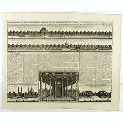
Description te vue de la Place d'Ispahan . . .
Pair of decorative views showing the Royal Palace at Isfahan (Esfahan) and the Royal Mosque of Abas the Great. From Chatelain's monumental 7 volume "Atlas Historique...
- $125 / ≈ €108
Date: Amsterdam, 1720
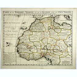
Carte de la barbarie, Nigritie et de la Guinée avec les pays voisins . . .
This great map of western Africa is based on Guillaume Delisle's map. It covers from the Barbary coast to below the equator. There is a mass of geographic detail and nota...
Date: Amsterdam, 1720
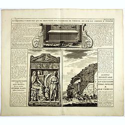
Antiquez curieuses qui se trouvent aux environs de Smyrne, et sur le chemin d'Ephese.
Folio sheet describing and depicting ancient Greek monuments and ruins in Smyrna (Izmir). From Chatelain's monumental 7 volume "Atlas Historique". Henri Abraham...
Date: Amsterdam, 1720
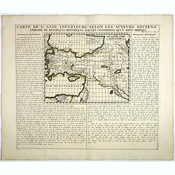
Carte De L'Asie Inferieure Selon Les Auteurs Anciens, Enrichie de Remarques Historiques sur les Changemens qui y sont arrivez.
Text page with inset map (220x269.mm.) of Turkey, including Cyprus from Chatelain's monumental 7 volume "Atlas Historique". Henri Abraham Chatelain (1684 – 17...
Date: Amsterdam, 1720
![Spiegel der Reden Voor de Wanhopende Actionisten. [Mirror for the reason of the despairing stockbrokers. ]](/uploads/cache/28094-250x250.jpg)
Spiegel der Reden Voor de Wanhopende Actionisten. [Mirror for the reason of the despairing stockbrokers. ]
Text page with copper engraving (150 x 100mm.) taken from Het groote tafereel der dwaasheid : vertoonende de opkomst, voortgang en ondergang der actie, bubbel en windnego...
Date: Amsterdam, 1720
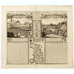
Succession Des Empereurs Du Japon Avec Une Description Du Meurtre De L'Empereur Cubo Et La Reception Des Ambassadeurs Hollandais. . .
The plate is showing the murder of the Emperor Cubo at Kyoto, the arrival of one of the early Dutch embassies.A small map of Honshu in a central panel. Plate from his &qu...
Date: Amsterdam, 1720
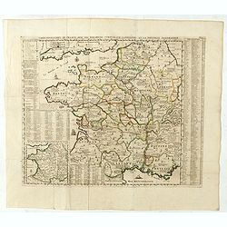
Carte Geographique du Royaume de France, avec des remarques curieuses sur l'ancienne, et la nouvelle geographie.
Map of France with a key table to the towns on both sides.Zacharie Chatelain (d.1723) was the father of Henri Abraham (1684-1743) and Zacharie Junior (1690-1754).They wor...
Date: Amsterdam, ca. 1720
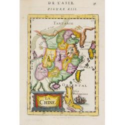
La Chine.
A charming small map of China, Taiwan, the Philippines, Korea, and Kyushu (Japan). By Allain Manesson Mallet (1630-1706), a well-traveled military engineer and geographer...
- $300 / ≈ €259
Date: Paris, 1720
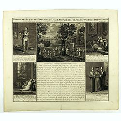
Mariage des Turcs & des Armeniens, avec la ma niere dont se font les demonstrations d'amour . . .
Showing the marriage rituals and lives of Turks and Armenians. Five engravings set round a text panel in French. From Chatelain's monumental 7 volume "Atlas Historiq...
- $150 / ≈ €129
Date: Amsterdam, 1720
Carta Hydrographica oder Algemeine Welt. . .
World map in Mercator projection. Showing California as an island. In the upper left and right-hand corner two ships. The map is showing the important trade routes.
Date: Augsburg, 1720
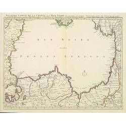
Seconde partie de la Crimee la Mer Noire. . .
The lower part of a set of two maps from the observations of Guillaume Delisle focusing on the Black Sea with wonderful detail of the surrounding regions. Includes Consta...
- $750 / ≈ €647
Date: Amsterdam, 1720

Tabula geographica Russiae Magnae pontus euxinus seu mare nigrum et tauriae regnum. . .
Decorative map of the Black Sea Region, with a large decorative cartouche. Shows Constantinople. Extends north to Moscow and Smolensko.
Date: Nuremberg, 1720
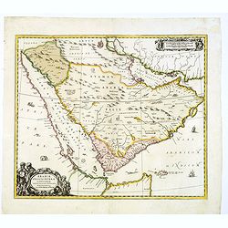
Arabiae Felicis, petrae et desertae.
A very striking map with a finely decorated title cartouche, published by Valk & Schenk, utilizing Jansson's original plate. Interestingly, this map uses the names th...
Date: Amsterdam, 1720
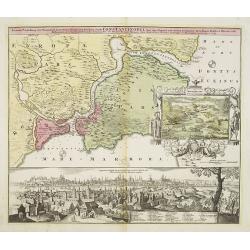
Accurate Vorstellung der Orientalisch Kayserlichen Haupt- und Residenz-Stadt Constantinopel samt ihrer Gegend und Zweyen . . .
The upper part shows Constantinople with adjoining regions. The view shows the former Christian church Hagia-Sophia, the Blue Mosque, three Egyptian obelisks, Sultan Sule...
Date: Nuremberg 1720

Carte de l'Ile de Java.
An inset plan of Batavia and clearly indicated rice fields, mountains, forests, towns in profile and even elephants suggest the wealth of detail found on this map. Modele...
Date: Amsterdam, 1720
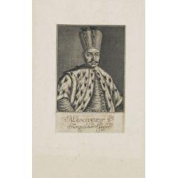
Mahomet V. Türkischer Kayser.
Portrait of Mahomet V. son of Mustapha II. succeeded in 1730, on the deposition of his uncle, Achmet III.Mahomet was more respectable for his pacific disposition, than hi...
Date: Germany, c. 1720

Carte de l'Ile de Java. . .
An inset plan of Batavia and clearly indicated rice fields, mountains, forests, towns in profile, and even elephants, suggesting the wealth of detail found on this map. M...
Date: Amsterdam, 1720
Harlekin en Bombario en den rouw.
Harlequin and Bombario in mourning, taken from Het groote tafereel der dwaasheid : vertoonende de opkomst, voortgang en ondergang der actie, bubbel en windnegotie, in Vra...
Date: Amsterdam, 1720
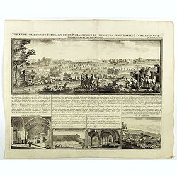
Vue et description de Bethleem et de Nazareth . . .
Decorative panoramic view of Bethlehem and Nazareth, among 3 other views of the Hall of the Annunciation and Church of Cana .From Chatelain's monumental 7 volume "At...
- $200 / ≈ €173
Date: Amsterdam, 1720
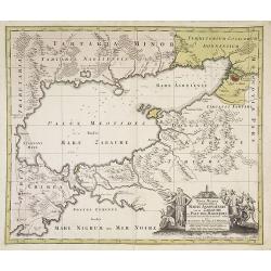
Maris Assoviensis vel de Zabache et Paludis Maeotidis. . .
A very detailed map showing the Black Sea, Azow and Rostow area. With a decorative allegorical cartouche, showing the costumes of the indigenous people of the region.
Date: Augsburg, 1720
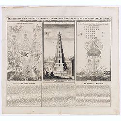
Description d'un des plus fameux temples des Chinois..
This impressive engraving is a wonderful example of Chatelain’s elegant plates.Divided in 3 panels, respectively showing the most important gods in the Chinese deities ...
Date: Amsterdam, ca. 1720
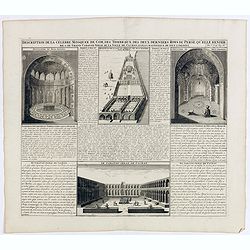
Description de la Celebre Mosquee de Com, Des Tombeaux Des Deux Derniers Rois de Perse qu'elle Renferme & du Grand Caravan-Serai De La Ville De Cachan Le Puls Magnifique de Tout L'Orient ...
Four views on one page with descriptive text showing the interior of the Mosquek, including the Sepulchre of Abas the Second and Sefy the First, along with the Tomb of th...
Date: Amsterdam, 1720

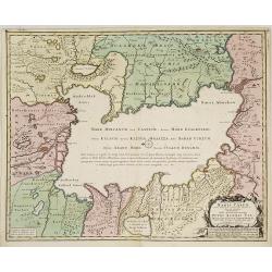
Carte nouvelle de Moscovie represente la partie Septentrionale dressée par G.De L'Isle. . .
Uncommon map covering the area north of Moscow, including Lapland. Prepared by G. de L'Isle.Joachim Ottens (1663 - 1719) and his sons Renier and Joshua were prominent Dut...
Date: Amsterdam, 1720
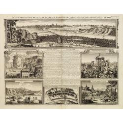
Vue et description de la Ville de Meaco Capitale du Japon. . .
The top part of the print shows a panoramic view of Meaco (Kyoto) at that time the capital of Japan, with a coach and horses in the foreground. Other parts show among oth...
Date: Amsterdam, 1720
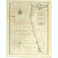
Costes de L'Afrique .. ..Cap de Bone Esperance..
In the upper right-hand corner inset map of Saldanha Bay. Numerous place names, soundings and sand banks are shown round the island and the regions are defined by origina...
Date: Amsterdam, 1720
Bronwater of geneesmiddel voor de zieke actionisten.
Springwater or potion for the sick shareholder, taken from Het groote tafereel der dwaasheid : vertoonende de opkomst, voortgang en ondergang der actie, bubbel en windneg...
Date: Amsterdam, 1720

Japonia Regnum.
It is the first map to correctly show Korea as a peninsula. The rare Covens and Mortier issue of this important map of Japan and Korea, originally published by Blaeu. Thi...
Date: Amsterdam, 1655 - 1720

Vue et description des principales villes de l'Armenie et de la Georgie avec les habillements des femmes du pays, et ceux des prêtres et religieux armeniens. . .Tom: V N° 11 Pag: 28
View and description of the principal Armenian and Georgian cities with illustrations of Armenian women's garments as well as priests' and monks' clothing. The views are ...
Date: Amsterdam, ca 1720
Het Groote Tafereel der Dwaasheid, vertoonende de opkomst, voortgang en ondergang der Actie, Bubbel en Windnegotie, in Vrankryk, Engeland, en de Nederlanden, gespleegt in den Jaare MDCCXX...
AN EARLY ISSUE of this biting and vulgar satire on the Mississippi and South Sea Bubbles and an extraordinary visual record with 78 plates of the first banking crash, sho...
Date: Amsterdam, 1720

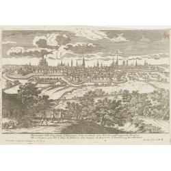
Amsterdam Capitale de la Hollande.
A panoramic of Amsterdam seen from 't IJ. Set within a decorative border, printed from a separate plate. Rare.
Date: Leiden, 1720
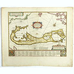
Mappa Aestivarum Insularum, alias Barmudas..
The map is the rare re-issue of the Blaeu's copperplate of 1630. The map includes the arms of Bermuda and England, and lists proprietors of the various tribes into which ...
Date: Amsterdam, 1720
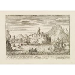
Ceuta Ville d'Afrique au D'estroit de Gibraltar.
A very RARE panoramic view of the city of Ceuta, including a numbered legend in both lower corners.Published by the brothers Chéreau, active in Paris at rue st.Jacques a...
Date: Paris c.1720
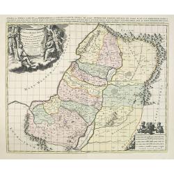
JUDEA seu TERRA SANCTA quae HEBRAEORUM sive ISRAELITARUM in suas duodecim Tribus divisa secretis ab invicem Regnis IUDA et ISRAEL expressis in super sex ultimi temporis eiusdem Terrae Provincijs. . .
Map of Palestine, showing the location of the various tribes, in two kingdoms, Judah and Israel as well as in six provinces. Shows Palestine on both sides of the Jordan, ...
Date: Amsterdam, 1720
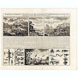
Particularitez Curieuses de l'Ile de St. Christophle et de la Province de Bemarin . . .
Six meticulously detailed and engraved scenes of the island of St. Kitts, also known as Saint Christopher, and the province of Bemarin, indigenous plants, animals, reptil...
Date: Amsterdam, 1720
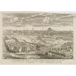
Nuremberg.
A very RARE panoramic view of the city of Nuremberg. The plate is numbered in red pencil in the upper right corner.Engraved by Pierre Aveline (Paris, c.1656 - 23 May 1722...
- $200 / ≈ €173
Date: Paris, 1690-1720
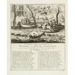
De kornet van vuil gewin of wortel en besse postiljon op zyn mager, doch niewlyks gemest varken uitschreewende de kompany is vol.
Page taken from "Het groote tafereel der dwaasheid : vertoonende de opkomst, voortgang en ondergang der actie, bubbel en windnegotie, in Vrankryk, Engeland, en de Ne...
Date: Amsterdam, 1720
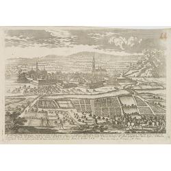
Ausbourg Ville Impériale d'Allemagne dans la Suabe.
A very RARE panoramic of the city of Augsburg. The plate is numbered in red pencil in the upper right corner.Engraved by Pierre Aveline (Paris, c.1656 - 23 May 1722). He ...
- $250 / ≈ €216
Date: Paris, 1690-1720

Carte des pavillons accompagnée d'observations pour en faire comprendre le blazon et les différentes devises aussy bien que d'une table alphabétique pour les trouver facilement.?
Map of 88 marine flags, including Malta, Turkey, Middelburg, Amsterdam, Portugal, Monaco, Tuscany, China, Nanking, the French Royal flag, French admiralty flag and mercha...
Date: Amsterdam, 1720
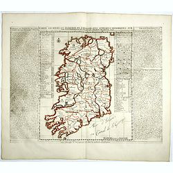
Carte ancienne et moderne de l'Irlande, avec quelques remarques sur son gouvernement . . .
Map of Ireland, based upon the ancient and modern cartographic information as of the beginning of the 18th Century. From Chatelain's monumental 7 volume "Atlas Histo...
- $200 / ≈ €173
Date: Amsterdam, 1720
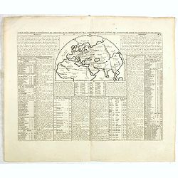
Carte pour servir à l'intelligence de l'histoire de la chronologie et de la géographie des empires des Assiriens, des Perses, des Egyptiens et des Chinois.
Interesting sheet with a map of the classical world showing the empires of the Assyrians, Persians, Egyptians and Chinese, with descriptive French text, from Chatelain's ...
Date: Amsterdam, 1720
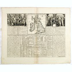
Carte du gouvernement militaire d'Angleterre où l'on représente l'état des officiers de guerre et celui des forces de terre et de mer.
Interesting sheet with a decorative map on the British Isles, with idyllic scenes showing councils of the various military officers of the British Isles, with descriptive...
Date: Amsterdam, 1720
Fribourg Ville d'Allemagne Capitale du païs de Brisgaw.
A very RARE panoramic of the city of Fribourg. The plate is numbered in red pencil in the upper right corner.Engraved by Pierre Aveline (Paris, c.1656 - 23 May 1722). He ...
- $250 / ≈ €216
Date: Paris, 1690-1720
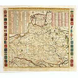
Carte De Pologne Avec La Chronologie Des Rois Et Des Ducs De Lithuanie, Ainsi Que Des Grands M. De L'Ordre Teutonique Les Evechez et Archeveches, et Les Armes Des Provinces . . .
Map of Poland with a key table to the towns, and 30 coats of arms on both sides, extending south the Black Sea. From Chatelain's monumental 7-volume "Atlas Historiqu...
- $1000 / ≈ €863
Date: Amsterdam, 1720

Nouvelle carte du Roiaume D'Alger divisée en toutes ses provinces, avec une partie due cotes D'Espagne . . .
Rare and detailed map of the coast of Algeria. Large inset map of the Bay of Alger (El-Jazir). Shows a coastline of Spain around Alicante. Two compass roses in the Medite...
Date: Amsterdam, 1720
Carte du Gouvernement de la Cour d'Espagne. . .
Engraved text sheet, providing a detailed description of the infrastructure of Spain's ecclesiastical and military government as well as information listed in a lengthy t...
- $75 / ≈ €65
Date: Amsterdam, ca. 1720
Philisbourg.
A very RARE panoramic view of the city of Philipsburg, including a numbered legend in both lower corners. The plate is numbered in black pencil in the upper right corner....
- $150 / ≈ €129
Date: Paris c.1720
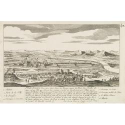
Ratisbonne.
A very RARE panoramic town view of the city of Ratisbonne, including a numbered legend in both lower corners. The plate is numbered in black pencil in the upper right cor...
- $200 / ≈ €173
Date: Paris c.1720
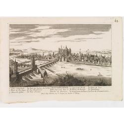
Treves en Allemend Trier.
A very RARE panoramic view of the city of Trier. The plate is numbered in red pencil in the upper right corner.Engraved by Pierre Aveline (Paris, c.1656 - 23 May 1722). H...
- $200 / ≈ €173
Date: Paris, 1690-1720
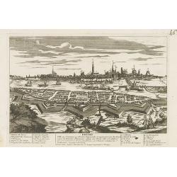
Breme.
A rare panoramic view of the city of Bremen, including a numbered legend in both lower corners.Published by the brothers Chéreau, active in Paris at rue st.Jacques au Gr...
- $200 / ≈ €173
Date: Paris c.1720
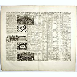
Carte du gouvernement ecclesiastique civil et militaire de l'Empire de l'ordre teutonique et de Malte et des villes anseatiques.
Interesting sheet with a detailed series of views showing the various councils of the Hanseatic League, including the councils of war, finance, state and the college of t...
- $75 / ≈ €65
Date: Amsterdam, 1720
Wegweiser duch das Chiurfurstenthumb Sachen.
Showing distances in-between towns in Saxen, Germany. In upper right hand corner inset map of Saxen, showing Leipzig, Dresden, Prague.More about cartographical curiositie...
- $75 / ≈ €65
Date: Amsterdam 1720
40 De gelegentheyt van ’t Paradys en ’ t Landt Canaan.
Bottom right:' t Amsterdam uytgegeven door Cornelis Dankerts voor aen op de Nieuwendijck in den Atlas met Previlegie.This Cornelis Danckerts ( the spelling of his name di...
- $250 / ≈ €216
Date: Amsterdam, 1720
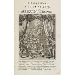
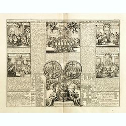
Uitlegginge der tytelplaat voor Arlequyn actionist.
Decorative print. Harlequin stockholder. The engraving (230x180mm.) depicts a kneeling conjuror with cups, balls and cards, Harlequin and Scaramouche drawing back curtain...
Date: Amsterdam, 1720
Tytel-print der actie-kraam of yoor-hof yan Quinquenpoix. . .
Page taken from "Het groote tafereel der dwaasheid : vertoonende de opkomst, voortgang en ondergang der actie, bubbel en windnegotie, in Vrankryk, Engeland, en de Ne...
- $100 / ≈ €86
Date: Amsterdam, 1720

Carte des Indes, de la Chine & des Isles de Sumatra, Java &c..
This fine and quite detailed general map extends from northern Japan to Timor and from India to New Guinea.There are very good details of towns and trade routes in modern...
Date: Amsterdam, 1720
![Waare afbeelding van den vermaarden Heer Quinquenpoix. [True portrait of the reknowed Mr. Quinquenpoix]](/uploads/cache/27965-250x250.jpg)
Waare afbeelding van den vermaarden Heer Quinquenpoix. [True portrait of the reknowed Mr. Quinquenpoix]
Page taken from Het groote tafereel der dwaasheid : vertoonende de opkomst, voortgang en ondergang der actie, bubbel en windnegotie, in Vrankryk, Engeland, en de Nederlan...
Date: Amsterdam, 1720

Nostre Dame de Lorette.
A very RARE panoramic of Lorette and the church, including a numbered legend in both lower corners.The plate is numbered in black pencil in upper right corner.Published ...
Date: Paris c.1720
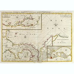
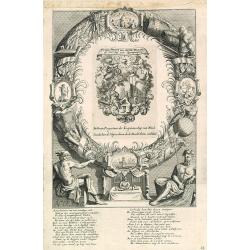
Carte Particuliere de Isthmus ou Darien qui Comprend le Golfe de Panama &c. Cartagena, et les Isles aux Environs.
Finely executed map of a portion of Central America, extending from the East Coast of Nicaragua and Costa Rica in the northwest to Cartagena and Santa Martha in modern Co...
- $1250 / ≈ €1079
Date: Amsterdam, 1720
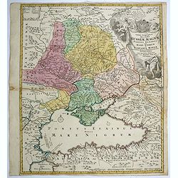
Tabula geographica qua pars Russiae Magnae..
A detailed map of western Russia, depicting the Ukraine, the Black sea, Turkey to the south, Romania and Bulgaria to the south west, Georgia to the east. Shows the cities...
Date: Nuremberg, 1720
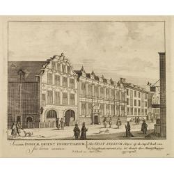
Het Oost Indisch Huys op de Suyd hock..
A decorative print of the East Indian House , the headquarters of the V.O.C., a place for meeting, trading and storage of spices and ship equipment.The maps and charts we...
Date: Amsterdam, 1720
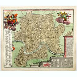
Urbis Romae Veteris ac Modernae Accurata Delineatio. . .
A wonderful 'bird's eye' view of the 'Eternal City' of Rome by Homann, although published in the first quarter of the eighteen century, the map portrays the city at the e...
Date: Nuremberg, ca 1720