Browse Listings
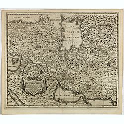
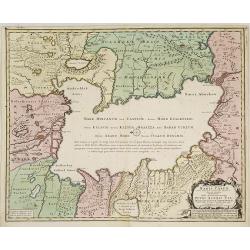
Carte la plus nouvelle et plus exacte du royaume de Perse . . .
This is a decorative map of Persia and Central Asia. It has very good details of the region east of the Caspian Sea, showing modern-day Uzbekistan. The region is labeled ...
- $400 / ≈ €345
Date: Leiden, 1719
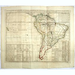
Nouvelle carte de geographie de .. Meridionale de l'Amerique
Chatelain's map of South America. The title is in two lines across the map. The tracks of Magellan, de la Maire, de Mendana, etc. are shown.On each side, borders appear a...
- $250 / ≈ €216
Date: Amsterdam, 1719
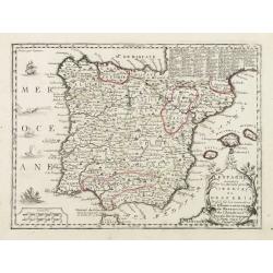
L'Espagne nominée Par les Anciens Grecs Iberia ou Hesperia..
Lovely small map of Spain with decorative title cartouche, vessels and a sea monster in the Atlantic Ocean.Presenting a panel in the upper right corner listing local rule...
Date: Paris, 1719
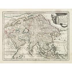
L' Asie Dressée Selon les Observations de Mrs. De l' Academie Royale des Sciences..
Delightful little map of Asia that conforms to the standard French model of the period. Hokkaido is attached to the mainland and Terre de Iesso is off the coast partially...
- $300 / ≈ €259
Date: Paris, 1719
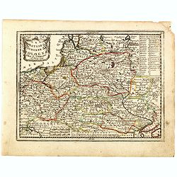
Les Estats de la Couronne de Pologne.
Lovely small map of Poland with title cartouche and a panel in the upper right corner listing local rulers.From Le Nouveau et Curieux Atlas Geographique et Historique.. b...
- $200 / ≈ €173
Date: Paris, 1719
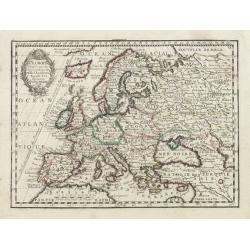
L' Europe Dressée sur les Observations de Mrs. de l' Academie Royale des Sciences..
Charming small map of Europe, including Iceland and the Mediterranean. Based on the geography of Guillaume Delisle.From Le Nouveau et Curieux Atlas Geographique et Histor...
Date: Paris, 1719
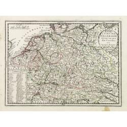
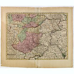
L'Empire D'Allemagne Divisé en ses dix Cercles et Autres Estats..
Map centered on Germany, including Switzerland, Austria, part of France, Northern Italy and Eastern Europe. With title cartouche and a panel in the lower left corner list...
- $60 / ≈ €52
Date: Paris 1719
![Nouvelle carte de la province de Kilan en Persie . . . (Iran]](/uploads/cache/39437-250x250.jpg)
Nouvelle carte de la province de Kilan en Persie . . . (Iran]
Decorative map of southern part of the Caspian Sea in Northern Iran. This well executed engraving was published in 1729 and 1727 by Pieter van der AA, in Leiden in "...
- $300 / ≈ €259
Date: Leiden, 1719
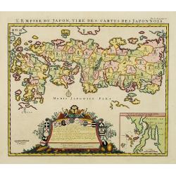
L'Empire du Japon, tire des cartes des Japonnois.
A good impression of this decorative map of Japan based on Reland's map of `1715, one of the earliest to use both Latin names and Japanese characters. With inset of the b...
Date: Amsterdam, 1719
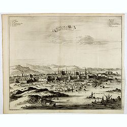
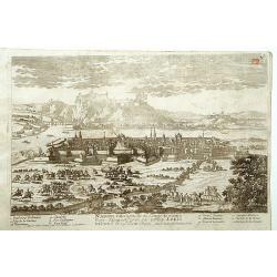
Astrakan, ville capitale du royaume du meme nom, en Moscovie. (Astrakhan)
Decorative view of Astrakhan. Astrakhan is where Europe ends and Central Asia begins. Its position on the Caspian Sea has ensured a long history as an important trading h...
- $300 / ≈ €259
Date: Leiden, 1719
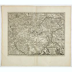
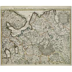
La Moscovie meridionale . . .
Decorative map centred on Moscow. This well executed engraving was published in 1729 and 1727 by Pieter van der AA, in Leiden in "Les Voyages tres-curieux et tres-re...
- $300 / ≈ €259
Date: Leiden, 1719
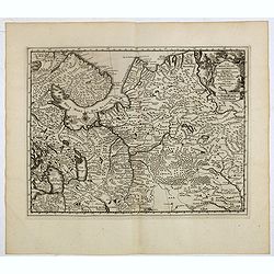
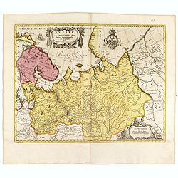
La Moscovie septentrionale . . .
Decorative view of area north of Moscow. This well-executed engraving was published in 1729 and 1727 by Pieter van der AA, in Leiden in "Les Voyages tres-curieux et ...
- $250 / ≈ €216
Date: Leiden, 1719
![[Title page] Le nouveau et curieux Atlas Géographique et historique ou Le Divertissement des Empereurs, Roys, et Princes. Tant dans laz Guerre que dans la Paix.](/uploads/cache/17244-250x250.jpg)
[Title page] Le nouveau et curieux Atlas Géographique et historique ou Le Divertissement des Empereurs, Roys, et Princes. Tant dans laz Guerre que dans la Paix.
Decorative title page. According to its title, this atlas was intended for the entertainment of emperors, kings, and princes!
Date: Paris, 1719
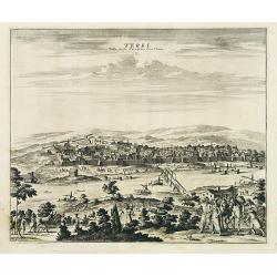
Terki, ville de la Circassie, dans l'Asie.
A very detailed panoramic view of Terki in the Caucasus, the capital of one of the most powerful Dagestani potentates of southeast Asia.Showing the Volga River.The town o...
Date: Leiden, c. 1719
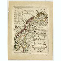
Le Royaume de Norwege Divisé en ses cinq Principaux Gouvernements. . .
Lovely small map of Norway, with much of Sweden to the East, vessel and sea monsters in the Norwegian Sea.It shows a text table in the upper left corner containing the na...
- $100 / ≈ €86
Date: Paris, 1719

Carte du Golfe de Bengale, mer des Indes et rivieres du Gange . . .
Detailed scare map of the Southern part of India with Ceylon. Good detail along the coasts of Malabar, Coromandel, the Maldives islands and the Kingdoms of Visipour, Golc...
Date: Leiden, 1719
La ville de Dantzic dans la Prusse Royale.
Decorative view of Danzig. This well executed engraving was published in 1719 by Pieter van der AA, in Leiden in "Les Voyages tres-curieux et tres-renommez faits en ...
- $400 / ≈ €345
Date: Leiden, 1719
Elbing. (Elblag in Northern Poland)
Decorative view of the town of Elblag in Northern Poland. This well executed engraving was published in 1729 and 1727 by Pieter van der AA, in Leiden in "Les Voyages...
- $400 / ≈ €345
Date: Leiden, 1719
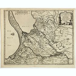
Les trois Iles, appellées en Allemand Werders, ou sont les Territoires de Dantzic, Marienbourg et Elbing dans la Prusse Royale avec les Côtes de la Mer Baltique, suivant la description de Olaus Jean Gotho...
Decorative regional map including the town of Danzig and the region south of it. East to the top. This well-executed engraving was published in 1729 and 1727 by Pieter va...
- $450 / ≈ €388
Date: Leiden, 1719
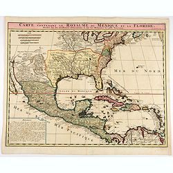
Carte contenant le Royaume du Mexique et la Floride.
This is a derivative of Delisle's landmark map of the southern part of North America.The detailed map shows many English settlements along the East Coast and carefully no...
- $1000 / ≈ €863
Date: Amsterdam, 1719
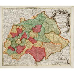
Saxoniae Superioris
Impressive title cartouche with miniature panoramic view of Leipzig, coat of arms, putti and Mercury.Johann Baptist Homann born in Kammlach (1663). He was engraver, map-s...
- $150 / ≈ €129
Date: Augsburg, 1720
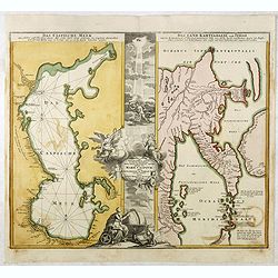
Das Caspische Meer / Das Land Kamtzadalie ...
Two maps on one sheet with the Caspian Sea on one side and northeastern Russia and Kamchatka on the other. The map of the Caspian Sea reflects the survey work of Russia�...
- $450 / ≈ €388
Date: Nuremberg, 1720
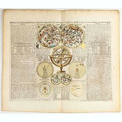
Premiere carte pour l'Introduction a l'histoire du monde, ou l'on remarque la Sphere, le Globe Celeste. . .
Featuring a small double hemisphere world map, showing California as an island, North and South Polar celestial hemispheres, an Armillary Sphere, below with smaller circu...
- $500 / ≈ €432
Date: Amsterdam, 1720

Huquang, Kiangsi, Chekiang ac Fokien.
A reissue of Janssonius' map of south east China, with wash color and uncolored cartouches.The map is based on the maps of Martin Martini, themselves based on Chinese sou...
Date: Amsterdam, 1720

A new map of the English Empire in America. . .
This fine English map of eastern North America including Canada engraved by John Harris and first published by Robert Morden. John Senex acquired and made minor alteratio...
Date: London, 1720
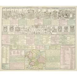
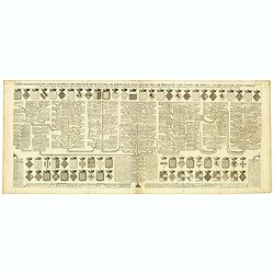
Kort Begryp van Duytsland, de drie Ryx Collegien in hunne Wapens en Zittingen. Kreits Verelingen en Aantekenigen door C. Specht't Utrectht.
Second state of this decorative table of family escutcheons, crests and coats of arms, for various German and Dutch princes and nobles of the 16th, 17th and 18th Centurie...
Date: Amsterdam, 1720
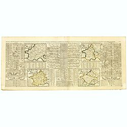
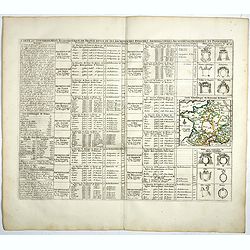
Nouvelle Carte des Differents Etats de la Monarchie Françoise Sous Iule Cesar, Sous les Rois de la Premiere, de la Seconde . . .
Four maps of France surrounded by historical and genealogical information to the history, chronology, ancient and modern genealogy of the french monarchy.Henri Abraham Ch...
- $75 / ≈ €65
Date: Amsterdam, 1720
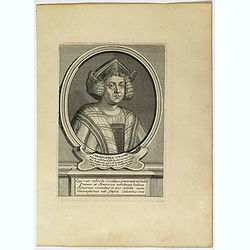
Christophe Colomb . . .
Fine portrait of Christopher Columbus (c.?1451 – 1506) engraved and published by Étienne Jehandier Desrochers ( Lyon 1668 - Paris 1741).Christopher Columbus was an Ita...
- $75 / ≈ €65
Date: Paris, 1720
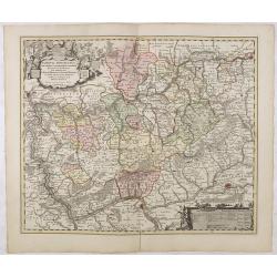
Nassovia Principatus Cum omnibus ei pertinentibus Comitatibus Dominiis ac Praefecturis ut et Confiniis intra Lahnun, Rhenum, et Moenum Flumina, ad situm verum exacte delineatus a Joh. Jac. Stetter. U.J.L. Idstenio-Nassovio . . .
Decorative map of the area between the rivers Rhine and Meuse, including Mainz, Koblenz, Frankfurt, Saarbrucken, etc.Includes an elaborate cartouche and coat of arms.The ...
- $150 / ≈ €129
Date: Amsterdam, 1720
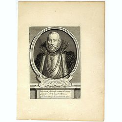
Ticho-Braché . . .
Uncommon portrait of Tycho Brahe, (1546 - 1601) engraved and published by Étienne Jehandier Desrochers ( Lyon 1668 - Paris 1741). Brahe was a Danish astronomer whose wor...
- $150 / ≈ €129
Date: Paris, 1720
Nova ac verissima Maris Caspii ante hac maximam fere partem nobis incogniti, ac Regionum adiacentium : Delineatio Iussu Invictissimi Principis Petri Alexii Fil. Magni Russorum Imperatoris / immenso labore et maximis sumptibus facta, atque ex ...
Covers portions of Iran, Turkmenistan, Kazakhstan, Russia and Azerbaijan. Relief is shown pictorially. Depth is shown by soundings. Oriented with north to the left. Rare.
- $750 / ≈ €647
Date: Amsterdam, 1720
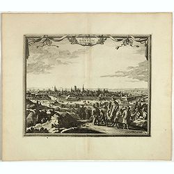
Namur.
A very RARE panoramic of the city of Namur, with a numbered legend in both lower corners.The plate is numbered in red pencil in upper right corner.Engraved by Pierre Avel...
- $150 / ≈ €129
Date: Paris, 1690-1720
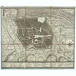
Plan de la ville de Treves.
Very rare town-plan of Trier by Didier Bugnon (1676-1736), geographer of the Duke of Lorraine. With numbered key (1-57) of the main buildings and buildings of the city. T...
Date: Paris?, 1720

Riga metropolis Livoniae.
A spectacular panoramic view of Riga, with legends numbered from a-z and 1-16 in German. With the title in a banderol.After a design by Friedrich Bernhard Werner (1690-1...
Date: Augsburg, ca. 1720

Norimberga.
A spectacular panoramic town-view of Nuremberg, with legends numbered from 1-39 in German. With the title in a banderol.After a design by Friedrich Bernhard Werner (1690...
Date: Augsburg, ca. 1720
![Mayence Mentz en allemand .. [Metz]](/uploads/cache/13109-250x250.jpg)
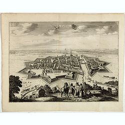
Mayence Mentz en allemand .. [Metz]
A very RARE panoramic view of the city of Metz, including a numbered legend in the lower corners. The plate is numbered in red pencil in the upper right corner.Engraved b...
- $200 / ≈ €173
Date: Paris 1690-1720
Carte de Moscovie. . .
Centred on Moscow, including Lapland. With fine uncolored title cartouche.
Date: Amsterdam, 1720
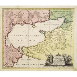
Maris Assoviensis vel de Zabache et Paludis Maeotidis. . .
A very detailed map showing the Black Sea, Azow and Rostow area.
Date: Augsburg, 1720
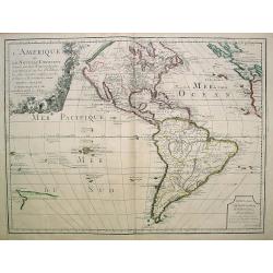
L'Amerique ou le Nouvelle Continent.. Dedieé et presenteé a monseigneur Law.
State one. The map has been prepared by Jean Baptiste Nolin (the elder) has a dedication to Monseigneur LAW controlleur general des finances .Rare general map of the Amer...
- $2200 / ≈ €1899
Date: Paris, 1720

Carte de la Nouvelle France, ou se voit le cours des Grandes Rivieres de S. Laurens & de Mississipi..
Derived from de Fer's 1718 map, from west of the Mississippi it contains a mass of inland detail with notes and vignettes of the indigenous peoples and fauna of North Ame...
Date: Amsterdam, 1720
Carte genealogique des comtes de Dreux, des Seigneursde Beaussart . . .
Genealogical chart of the earls of Dreux, from Chatelain's monumental 7 volume "Atlas Historique". Henri Abraham Chatelain (1684 – 1743) was a Huguenot pastor...
- $50 / ≈ €43
Date: Amsterdam, 1720
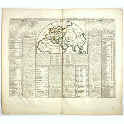
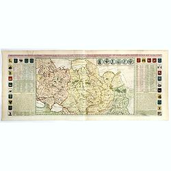
Carte pour servir à l'intelligence de l'histoire de la chronologie et de la géographie des empires des Assiriens, des Perses, des Egyptiens et des Chinois.
Interesting sheet with a map of the classical world showing the empires of the Assyrians, Persians, Egyptians and Chinese, with descriptive French text, from Chatelain's ...
- $75 / ≈ €65
Date: Amsterdam, 1720
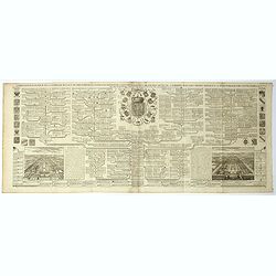
Carte du Gouvernement Ecclesiastique de France Divise en ses Archeveschez, Eveschez, Archidiaconnez, Archipretrez, Doyennez, et Parroisses.
This impressive plate provides a comprehensive list of the ecclesiastical divisions in the country with their corresponding coats of arms. A small inset map depicts the l...
- $55 / ≈ €47
Date: Amsterdam, 1720
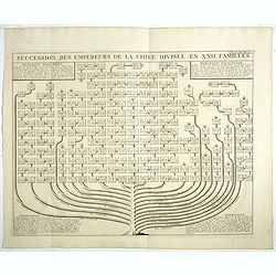
Succession Des Empereurs De la Chine divisée en XXII. Familles.
Showing successions of the Emperors of China divided into 22 families, copper engraved plate from "Atlas Historique". Zacharie Chatelain (d.1723) was the father...
- $100 / ≈ €86
Date: Amsterdam, 1720

Vue et Description de Quelques-Uns des Principaux Forts des Hollandois dans les Indes .
Interesting sheet with seven detailed views illustrating the most important Dutch V.O.C. trading outposts and fortified colonial possessions in the East Indies, including...
Date: Amsterdam, 1720
Carte genealogique de la famille Royale de Brunswick . .
A very detailed composite sheet with a genealogical table of the German royal families of Brunswick, Luneburg and Hanover, with descriptive French textZacharie Chatelain ...
- $50 / ≈ €43
Date: Amsterdam, ca. 1720
Russiae vulgo Moscovia dictae, Partes Septentrionalis. . .
In the north the Murmansk Sea. Including the western coast of Nova Zembla. Title cartouche and two cartouches, the bottom right one showing two hunters, bears, stags etc....
Date: Amsterdam, 1720
Carte du gouvernement ecclesiastique d'Angleterre . . .
Elegant engraving of the ecclesiastical government of England, with an engraving showing three images: in the centre, an ecclesiastical assembly (Convocation of the Clerg...
- $100 / ≈ €86
Date: Amsterdam, 1720
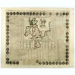
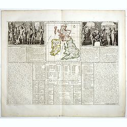
Carte Pour l'Introduction a l'Histoire d'Angleterre, ou l'on Voit son Premier Gouvernement, et l'Etat Abrege de cette Monarchie sous les Empereurs Romains, et sous les Rois Saxons.
The sheet includes a large inset map of Roman Britain including the English Channel and the western coast of France (200 x 255mm.). It also provides a wealth of informati...
- $200 / ≈ €173
Date: Amsterdam, 1720
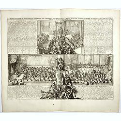
Représentation du parlement d'Angleterre, les chambres assemblées . . .
Engraving showing the British Parliament and an assembly before the King of England. From Chatelain's Atlas Historique, 1732-1739. In upper right margin: 'Tom. 7. No 26.H...
- $80 / ≈ €69
Date: Amsterdam, 1720
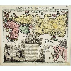
Imperium Japonicum.
The map is based on Engelbert Kaempfer's map of 1727. It shows a much-distorted outline for the Island of Japan and a wonderful decorative cartouche top left.Tobias Conra...
Date: Augsburg 1720
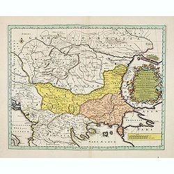
Illyricum Orientis In quo Partes II. Moesia et Thracia. Provinciae XI.
Attractive historical map of the area west of the Black Sea, today's Bulgaria, Rumania, etc. Based on the cartography of Nicolas Sanson and published by Covens and Mortie...
Date: Amsterdam, c. 1720
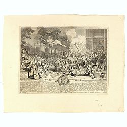
Monument consacré a la posterité en memoire de la folie incroyable de la XX. année du XVIII. siecle. Ter eeuwiger gedagtenisse der dwaasheid van het XX. jaar der XVIII. eeuw.
Monument consecrated to posterity in memory of the unbelievable folly of the 20th year of the 18th century.A caricature in prose and verse satirizing the first truly inte...
- $250 / ≈ €216
Date: Amsterdam, 1720
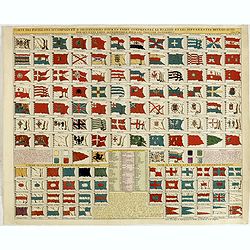
Carte des pavillons accompagnée d'observations pour en faire comprendre le blazon et les différentes devises aussy bien que d'une table alphabétique pour les trouver facilement.
A plate of 88 marine flags, including Malta, Turkey, Middelburg, Amsterdam, Portugal, Monaco, Tuscany, China, Nanking, the French Royal flag, the French admiralty flag an...
- $1200 / ≈ €1036
Date: Amsterdam, 1720
Het Groote Tafereel der Dwaasheid, vertoonende de opkomst, voortgang en ondergang der Actie, Bubbel en Windnegotie, in Vrankryk, Engeland, en de Nederlanden, ...
FIRST ISSUE of this biting and vulgar satire on the Mississippi and South Sea Bubbles and an extraordinary visual record with 78 plates of the first banking crash, show...
- $7500 / ≈ €6474
Date: Amsterdam, 1720
Carte du gouvernement d'Angleterre où l'on représente l'Etat des officiers de Guerre. . .
Decorative map on the British Isles, with idyllic scenes showing councils of the various military officers of the British Isles. Henri Abraham Chatelain (1684 – 1743) w...
- $50 / ≈ €43
Date: Amsterdam, 1720

Nova tabula geographica complectens borealiorem..
A finely engraved pair of maps designed to be cut and joined together to provide a continuous coastline of North America from the Carolinas to Newfoundland and along the ...
Date: Amsterdam 1720
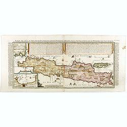
Carte de l'Ile de Java: partie Occidentale, partie Orientale, Dressée tout nouvellement sur les Mémoirs les plus exacts, Avec une Table des principales villes de cette Ile. . .
One of the finest large-scale maps of Java, giving good information regarding the VOC settlements An inset plan of Batavia and clearly indicated rice fields, mountains, f...
- $1500 / ≈ €1295
Date: Amsterdam, 1720
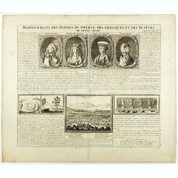
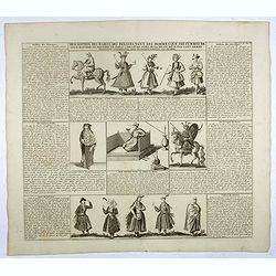
Habillement des femmes de Smyrnes, des Grecques et des Juifs de cette ville.
Four portraits of Smirne women in typical dress, each with a descriptive engraved text. From Chatelain's monumental 7 volume "Atlas Historique".Henri Abraham Ch...
Date: Amsterdam, 1720
Partie Meridionale de Moscovie. . .
Centered on Moscow including Azow and part of present-day Ukraine in the bottom part of the map. The map is based on Delisle's important map of the region with revisions ...
- $200 / ≈ €173
Date: Amsterdam, 1720
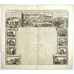
Vue et description de la Ville de Lovango dans le Royaume du Congo. . .
On top a large view of the fabled city of Lovango, text surrounded by ten vignettes of the people and ceremonies of the Kingdom of Congo.Zacharie Chatelain (d.1723) was t...
Date: Amsterdam, 1720
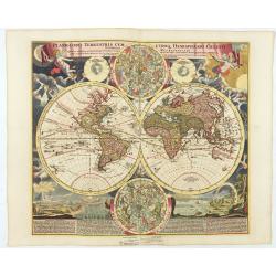
Planiglobii Terrestris Cum Utroq Hemisphaerio.
Vibrantly decorative world map surrounded by vivid engravings of natural phenomena such as waterspouts, a rainbow, earthquakes, and a volcano. Windheads occupy the starry...
Date: Nuremberg, c. 1720
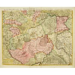
Partie Meridionale de Moscovie..
Centered on Moscow, including Azow in the bottom part of the map.The Amsterdam publishing firm of Covens and Mortier (1721 - c. 1862) was the successor to the extensive p...
- $300 / ≈ €259
Date: Amsterdam 1720
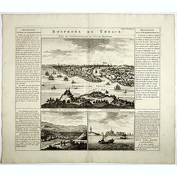
Bosphore de Thrace.
This handsome folio sheet present three views of the strategically important Bosporus. At top is a large decorative bird's-eye view of Istanbul as viewed from across the ...
Date: Amsterdam, 1720
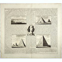
Description des piramides d'Egypte tant au départ qu'au dehors . . .
Engraved text page with 5 views of the pyramids and an image of the Sphinx. From Chatelain's monumental 7 volume "Atlas Historique".Henri Abraham Chatelain (168...
- $36 / ≈ €31
Date: Amsterdam, 1720
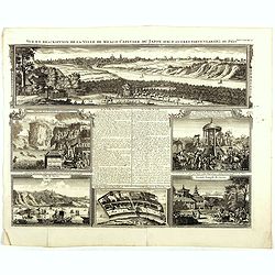
Vue et description de la Ville de Meaco Capitale du Japon. . .
Top part of the print shows the town of Meaco (Kyoto) at that time the capital of Japan, with a coach and horses in the foreground. Other parts show among other things th...
- $450 / ≈ €388
Date: Amsterdam, 1720
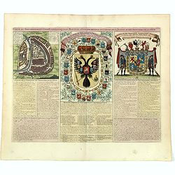
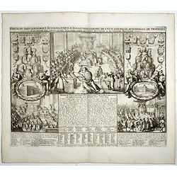
Carte du gouvernement civil ecclésiastique de moscovie, l'état des revenus et l'ordre de la justice et des officiers de la cour.
Interesting sheet with a detailed plan of Moscow, plus two large coats-of-arms, with descriptive French text, from Chatelain's monumental 7 volume Atlas Historique. In up...
- $950 / ≈ €820
Date: Amsterdam, 1720
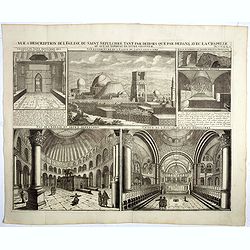
Vue & description de l'Eglise du Saint Sepulchre tant par dehors que dedans . . .
Shows various interiors and exterior views of the Church of the Holy Sepulcher in Jerusalem. From Chatelain's monumental 7 volume "Atlas Historique".Henri Abrah...
Date: Amsterdam, 1720

Imperii Sinarum nova descriptio.
Schenk and Valk's rare early 18th century issue of Janssonius milestone map of China, Korea and Japan after Martino Martini. Engraved by Johannes van Loon. The overall ba...
Date: Amsterdam, ca. 1720
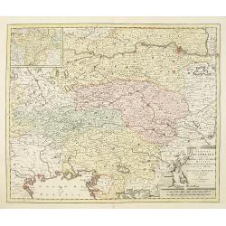
Circuli Austriaci in quo sunt. . .
Fine map of Austria, with in upper left corner a inset map of Tirol.Joachim Ottens (1663 - 1719) and his sons Renier and Joshua were prominent Dutch booksellers and map p...
- $200 / ≈ €173
Date: Amsterdam, 1720
Het Groote Tafereel der Dwaasheid.
AN EARLY ISSUE of this biting and vulgar satire on the Mississippi and South Sea Bubbles and an extraordinary visual record with 78 plates of the first banking crash, sho...
Date: Amsterdam, 1720
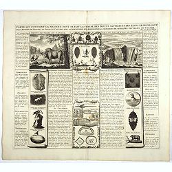
Carte qui contient la manière.. Niagara..
A series of 12 engravings together with descriptive text, derived from the works of Lahontan and Hennepin, illustrating the methods of the Indians hunting buffalo and sim...
Date: The Hague 1720
Carte generale des Etats du Czar. Empereur de Moscovie, ou L'on voit ce que ce prince possede en Europe ..
Impressive map of Russia Tartary and part of China with key tables to the towns. Depicting the different states belonging to the Czar in Asia and Europe, showing the path...
- $900 / ≈ €777
Date: Amsterdam, ca. 1720
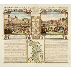
Succession Des Empereurs Du Japon Avec Une Description Du Meurtre De L'Empereur Cubo Et La Reception Des Ambassadeurs Hollandais. . .
The plate is showing the murder of the Emperor Cubo at Kyoto, the arrival of one of the early Dutch embassies.A small map of Honshu in a central panel. Plate from his &qu...
- $400 / ≈ €345
Date: Amsterdam, 1720
Carte des Grisons et des Communautez qui Composent leurs Ligues, les Etats de St. Gal, Neuchastel, Geneve et Quelques Autres Etats Alliez des Suisse.
This finely engraved sheet provides the history of various cities and regions allied with Switzerland at the beginning of the eighteenth century. The top section of the s...
- $150 / ≈ €129
Date: Amsterdam, 1720
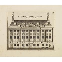
D' Admiralyteyts Huys - La maison de l'Amirauté.
Decorative print of the Admiralty House of the V.O.C., now-a-days Maritime Museum in Amsterdam.
Date: Amsterdam, c.1720
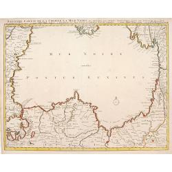
Seconde partie de la Crimee la Mer Noire. . .
The lower part of a set of two maps from the observations of Guillaume Delisle focuses on the Black Sea with wonderful detail of the surrounding regions. Includes Constan...
- $500 / ≈ €432
Date: Amsterdam, 1720
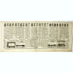
Description des habits des Persans..
This impressive engraving is a wonderful example of Chatelain’s elegant plates.Ornamented with numerous vignettes showing the costumes of the ancient Persians.General i...
- $150 / ≈ €129
Date: Amsterdam, ca. 1720
Carte genealogique de la maison des Valois. . .
This impressive engraving is a wonderful example of Chatelain’s elegant plates from his "Atlas Historique, Ou Nouvelle Introduction A L’Histoire …", Tom 7...
- $50 / ≈ €43
Date: Amsterdam, ca. 1720

Carte Particuliere d'une Partie d'Asie ou sont Les Isles D'Andemaon, Ceylan, Les Madives . . .
An impressive large sheet chart including the Red Sea, the coasts of Somali, Yemen, east coast of the Arabian peninsula. One of the early maps to focus on this area. Nume...
- $1500 / ≈ €1295
Date: Amsterdam, 1720