Browse Listings
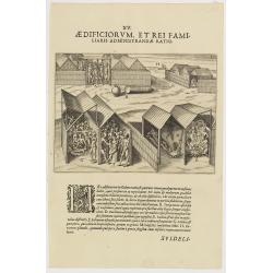
XV. Aedificiorum, et Rei Familiaris Administandae Ratio.
A village-scene in Guinea.Theodore de Bry, a German engraver and book dealer, began a compilation of early voyages in 1590 and had published six parts at the time of his ...
- $100 / ≈ €86
Date: Frankfurt, 1609
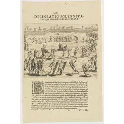
XVI. Delineatio Solennitatis, qua Nobiles Creari Solent.
Fine print of a Ceremony of electing or appointing a Nobleman in Guinea. Text below the engraving with an explanation in Latin : "During this ceremony there is a gre...
- $90 / ≈ €78
Date: Frankfurt, 1609
![[Bantam].](/uploads/cache/37941-250x250.jpg)
[Bantam].
Text engraving showing the arrival of the Dutch fleet at Bantam from "Premier livre de l'histoire de la navigation aux Indes Orientales, par les hollandois, et des c...
- $150 / ≈ €129
Date: Amsterdam, Cornille Nicolas, 1609
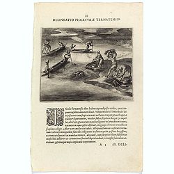
Delineatio Piscationum Ternatensis.
Fishing scene on Ternate island, Maluku, Indonesia.Theodore de Bry, a German engraver and book dealer, began a compilation of early voyages in 1590 and had published six ...
- $80 / ≈ €69
Date: Frankfurt, 1609
![[View of the arrival of Cornelis de Houtman's fleet at Bantam, Java.].](/uploads/cache/37937-250x250.jpg)
[View of the arrival of Cornelis de Houtman's fleet at Bantam, Java.].
Engraved map of Bantam on Java with a lettered key (A-N) showing the arrival of Cornelis de Houtman’s fleet at Bantam, Java in 1596. Houtman’s four vessels, the Amste...
- $200 / ≈ €173
Date: Amsterdam, Cornille Nicolas, 1609
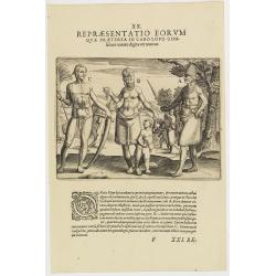
XX. Repraesentatio Eorum Quae Praeterea in Cabo Lopo Gonfalues. . . (More inhabitants of Cabo Lopo Gonsalues)
Here we see more figures of Cabo Lopo Gonsalues and Rio de Gabon. A: a distinguished man decked out in his finery and carrying several types of knives in his belt. In his...
- $100 / ≈ €86
Date: Frankfurt, 1609
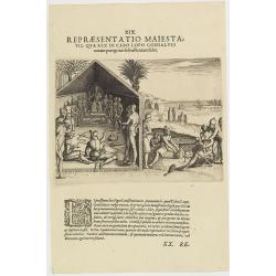
XIX. Repraesentatio Maiestatis, qua rex in Cabo Lopo Gonsalves . . . (How the chief of Cabo Lopo Gonsalues presents himself )
This describes the places they call Cabo Lopo Gonsalues and Rio de Gabon, where the chief receives his visitors. He sits on a chair placed upon a platform with two or thr...
- $100 / ≈ €86
Date: Frankfurt, 1609
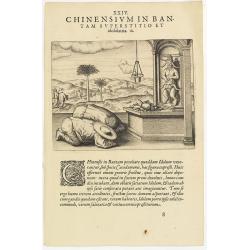
Chinensium in Bantam Superstitio et idololatria. 18. ( How the Chinese worship their idols in Bantam)
How the Chinese worship their idols in Bantam. As can be seen here, the Chinese worship their idol, which takes the form of a devil. They lay offerings of fruit on an alt...
- $100 / ≈ €86
Date: Frankfurt, 1609
![[Celebrating the arrival of the Dutch in Turban].](/uploads/cache/37949-250x250.jpg)
[Celebrating the arrival of the Dutch in Turban].
Text engravings of a tournament in Turban. On 23rd January 1599, the Dutch landed at Turban (on the north coast of Java) with several small boats. Great crowds of people ...
- $150 / ≈ €129
Date: Amsterdam, Cornille Nicolas, 1609
![[Plants and fruits of the East Indies].](/uploads/cache/37951-250x250.jpg)
[Plants and fruits of the East Indies].
Two text engravings from "Premier livre de l'histoire de la navigation aux Indes Orientales, par les hollandois, et des choses a eux advenues . . . ", being the...
- $50 / ≈ €43
Date: Amsterdam, Cornille Nicolas, 1609
![[Foreign Merchants at Bantam].](/uploads/cache/37943-250x250.jpg)
[Foreign Merchants at Bantam].
Two text engravings from "Premier livre de l'histoire de la navigation aux Indes Orientales, par les hollandois, et des choses a eux advenues . . . ", being the...
- $100 / ≈ €86
Date: Amsterdam, Cornille Nicolas, 1609
![[Ambon].](/uploads/cache/37953-250x250.jpg)
[Ambon].
Text engraving showing a bay on the Island of Ambon, an island in the Maluku Islands (Moluccas) of eastern Indonesia. Above the map a lettered key (A-D). Text engraving f...
- $150 / ≈ €129
Date: Amsterdam, Cornille Nicolas, 1609
![[Ternate].](/uploads/cache/37954-250x250.jpg)
[Ternate].
Text engraving showing a bay on the Island of Ternate, an island in the Maluku Islands (Moluccas) of eastern Indonesia. Above the map a lettered key (A-E). Text engraving...
- $100 / ≈ €86
Date: Amsterdam, Cornille Nicolas, 1609
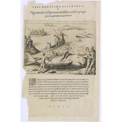
Pars Undecima Orientalis X. Quomodo in Septentrionalibus insulis prope. (How the inhabitants catch whales off the east coast of Madagascar.)
How the inhabitants catch whales off the east coast of Madagascar. When the natives of Santa Marta, off the east coast of Madagascar see a whale, they row out in their li...
- $100 / ≈ €86
Date: Frankfurt, 1609
![[Java Fruits].](/uploads/cache/37933-250x250.jpg)
[Java Fruits].
Text engraving of fruits on Java from "Premier livre de l'histoire de la navigation aux Indes Orientales, par les hollandois, et des choses a eux advenues . . . &qu...
- $75 / ≈ €65
Date: Amsterdam, Cornille Nicolas, 1609
![[Sumatra]](/uploads/cache/37955-250x250.jpg)
[Sumatra]
Text engraving from "Premier livre de l'histoire de la navigation aux Indes Orientales, par les hollandois, et des choses a eux advenues . . . ", being the clas...
- $50 / ≈ €43
Date: Amsterdam, Cornille Nicolas, 1609
![[Madagascar].](/uploads/cache/37962-250x250.jpg)
[Madagascar].
Two text engravings from "Premier livre de l'histoire de la navigation aux Indes Orientales, par les hollandois, et des choses a eux advenues . . . ", being the...
- $125 / ≈ €108
Date: Amsterdam, Cornille Nicolas, 1609
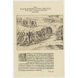
XXI. Repraesentatio Bellorum, Quae Aethiopes Invicem . . .
A fight between Ethiopian warriors.Theodore de Bry, a German engraver and book dealer, began a compilation of early voyages in 1590 and had published six parts at the tim...
- $75 / ≈ €65
Date: Frankfurt, 1609
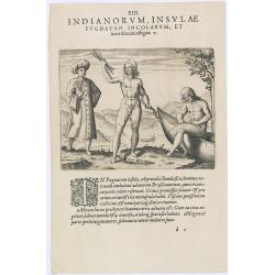
Indianorum, Insulae Pugnatan Incolarum. (The natives of the island of Pugnatan)
There was an island called Pugnatan at the western entrance to the Strait of Sudan, where the natives went about completely naked. Like the natives of Brazil, their hair ...
- $100 / ≈ €86
Date: Frankfurt, 1609
![[Javanese gamelan orchestra]](/uploads/cache/37960-250x250.jpg)
[Javanese gamelan orchestra]
Two text engravings from "Premier livre de l'histoire de la navigation aux Indes Orientales, par les hollandois, et des choses a eux advenues . . . ", being the...
- $75 / ≈ €65
Date: Amsterdam, Cornille Nicolas, 1609
![[Sunda].](/uploads/cache/37956-250x250.jpg)
[Sunda].
Text engraving and coastal profiles in wood block from "Premier livre de l'histoire de la navigation aux Indes Orientales, par les hollandois, et des choses a eux ad...
Date: Amsterdam, Cornille Nicolas, 1609
![[Tropical fruits of Java].](/uploads/cache/37934-250x250.jpg)
[Tropical fruits of Java].
Two text engravings of fruits on Java from "Premier livre de l'histoire de la navigation aux Indes Orientales, par les hollandois, et des choses a eux advenues . . ....
- $75 / ≈ €65
Date: Amsterdam, Cornille Nicolas, 1609
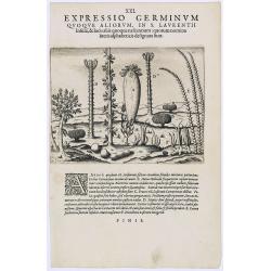
Expressio Germinum Quoque Aliorum, in S. Lavrentii.
Plants found in the island of S. Laurenti [Madagascar]. A’ denotes a tree with only a few twigs on the top. From this tree, canoes and boats are made. ‘B’ is a bush...
- $100 / ≈ €86
Date: Frankfurt, 1609
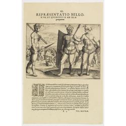
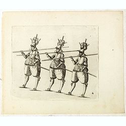
VI. Repraesentatio Bellorum, et Quomodo se ad Illa praeparent. (How the natives fight each other)
This shows how the men go to war and which weapons they use. They hold large square shields, about six feet high and four feet wide, made of cane and fortified with ox-hi...
- $90 / ≈ €78
Date: Frankfurt, 1609
![[Bantam].](/uploads/cache/37970-250x250.jpg)
[Bantam].
Text engravings from "Premier livre de l'histoire de la navigation aux Indes Orientales, par les hollandois, et des choses a eux advenues . . . ", being the cla...
Date: Amsterdam, Cornille Nicolas, 1609
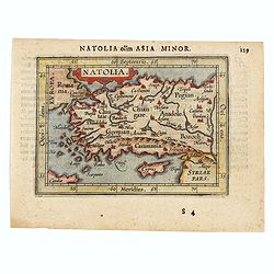
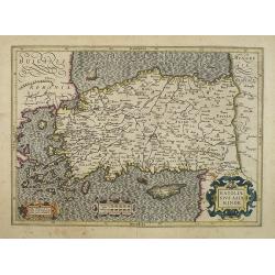
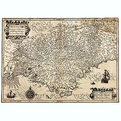
Natolia olim Asia Minor.
Genuine antique map "Natolia" by Abraham Ortelius from Epitome Theatri Orbis Terrarum, published in Antwerp in 1609. This charming 400-year-old miniature copper...
- $200 / ≈ €173
Date: Antwerp, 1609
![[Chinese Merchants and temple].](/uploads/cache/37966-250x250.jpg)
[Chinese Merchants and temple].
Two text engravings of Chinese merchants on Java and a Chines temple from "Premier livre de l'histoire de la navigation aux Indes Orientales, par les hollandois, et ...
- $100 / ≈ €86
Date: Amsterdam, Cornille Nicolas, 1609
![[Native Flora of Java].](/uploads/cache/37964-250x250.jpg)
[Native Flora of Java].
Text engraving of native flora of Java from "Premier livre de l'histoire de la navigation aux Indes Orientales, par les hollandois, et des choses a eux advenues . . ...
- $75 / ≈ €65
Date: Amsterdam, Cornille Nicolas, 1609
![[Bantam].](/uploads/cache/37963-250x250.jpg)
[Bantam].
Text engraving showing some merchants of Bantam, from "Premier livre de l'histoire de la navigation aux Indes Orientales, par les hollandois, et des choses a eux adv...
- $75 / ≈ €65
Date: Amsterdam, Cornille Nicolas, 1609
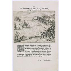
Delineatio Foederis Hollandorum cum Rege Calecutanorum pacti.
A treaty between the Dutch and the king of Calicut. The Dutch Admiral, Steffan van der Haagen already knew that the people of Calicut, on the Malabar Coast of India, were...
- $100 / ≈ €86
Date: Frankfurt, 1609
![[Title page] Germaniae Tabule Geographicae ...](/uploads/cache/43267-250x250.jpg)
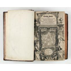
[Title page] Germaniae Tabule Geographicae ...
This is the title page to the volume of the atlas devoted to maps of Germany. According to Shirley the "early sectional parts of his "Atlas" each had Manne...
Date: Amsterdam, 1585-c.1610
(Title page) Principum Christianorum Stemmata.
Uncommon title page. From Antonio Albizzi, "Principum Christianorum Stemmata ab Antonio Albizio Nobili Florentino collecta: et Cum brevibus ejusdem notationibus ex A...
- $200 / ≈ €173
Date: Strasbourg, 1610
Natoliae Sive Asia Minor.
Map of Turkey, also depicting Cyprus.
- $750 / ≈ €647
Date: Amsterdam, 1610
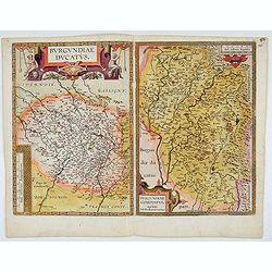
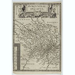
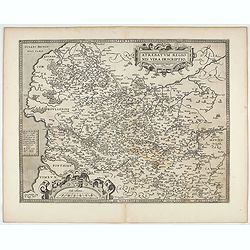
Burgundiae Ducatus. Burgundiae Comitatus.
Separately issued map of Burgundy area. Two maps of Burgundy region on a plate. Separately published map, without text on the verso. Second state with the date 1597 remov...
Date: Antwerp, after 1612
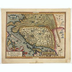
Chinae, olim Sinarum Regionis, nova descriptio. Auctore Ludovico Georgio.
The first map of China ever to appear in a Western atlas, west to the top. When this map appeared, it was by far the most accurate one of China.The map is based on a manu...
- $5500 / ≈ €4748
Date: Antwerp, 1608 /1612
Gelriae, Cliviae, Finitimorumque Locorum Verissima Descriptio.
From the very rare Galle edition of the Ortelius Atlas, published after 1612. Fine map of Geldria and Limburg, prepared by Christian s'Grooten. Very fine title cartouche ...
Date: Antwerp, after 1612

Limburgensis Ducatus Tabula Nova.
Map of Limburg, prepared by the Antwerp expert in law and mathematics Aegidius Martini. After 1600 Jan Baptist Vrients acquired the stock and the plates of Ortelius' Thea...
Date: Antwerp, 1606-1612
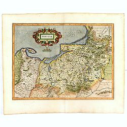
Prussia .
Important early map showing coast of Baltic Sea in Prussia, today Poland, prepared by the German cartographer Gaspher Henneberg of Erlich. Embellished with a large strapw...
Date: Amsterdam, 1612

Hydrograhica descriptio
This very rare chart is important as the first printed sea chart of the Mediterranean coast of Spain, Gibraltar, also depicting the northern coast of Marocco.Willem Bar...
Date: Amsterdam, W.Blaeu, 1612
Prussia .
An early map of northern Poland from the "Atlas Minor" (Gerhard Mercator / Jodocus Hondius). Extends from Memel to Torun and the Narew River. With two sailing s...
- $300 / ≈ €259
Date: Amsterdam, 1612
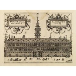
Domus Hansae Teutonicae / Sacri Romani Imperii. (Antwerp townhall)
From Ludovico Guicciardini.'s description of the Netherlands "Beschrijvinghe van alle de Nederlanden anderssins ghenoemt Neder-Duytslandt", published by Willem ...
- $100 / ≈ €86
Date: Amsterdam, 1612
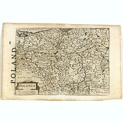
Polonia. (With text page)
Early map of Poland (168x250mm.) printed on a text page, together with another giving a description of the region in English.
- $150 / ≈ €129
Date: Amsterdam, 1612
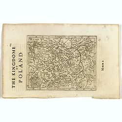
Polonia et Silesia. (With text page)
Early map of Poland. With English title above the map and an description of the region in English on verso.
- $250 / ≈ €216
Date: Amsterdam, 1612

Tartariae sive Magni Chami Imperium.
This is a very early depiction of the northern Pacific, with the first mapping of Northwest Coast of America and probably the first map to name California 'C. Califormio...
- $2500 / ≈ €2158
Date: Antwerp, c. 1608-1612
Burgundiae Ducatus.
Map of Burgundy region without text on the verso. Second state with the date 1597 removed from the title cartouche. This is the rarest Burgundy map of the four that Ortel...
- $500 / ≈ €432
Date: Antwerp, after 1612

Sardinia / Sicilia.. / Corfu / Zerbi.. / Elba / Malta. . .
Six very fine and early maps on one sheet. Including the islands of Sicily, Corfu, Sardinia, Zerbi (Djerba), Elba and Malta.The map of Malta has a sinking ship at Cala di...
Date: Antwerp, 1570-1612
Cruydt-Boeck van Remberus Dodonaeus. . .
Scarce, the last edition of Dodoens' Cruydt-Boeck, one of the most influential and important botanical works of the 16th and 17th centuries. With richly engraved frontisp...
Date: Leyden, 1612

Ruremunda Gelriae opp.
A bird's eye town-plan of the town of Roermond. From the first Dutch translation of Guicciardini's description of the Netherlands.
Date: Amsterdam, 1612
Artois. Atrebatum Regionis Vera Descripto.
Prepared by Jacob Surhon who made a manuscript map of Artois for which he received 36 Livres from Charles V in 1554. For security reasons the map was not published. Only ...
- $500 / ≈ €432
Date: Antwerp, after 1612
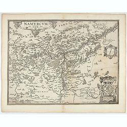
Namurcum Comitatus.
Prepared by Jacques Surhon in 1555. His manuscript map was for security reason not published. Only in 1579, when Antwerp was independent for a short time, Ortelius used a...
- $500 / ≈ €432
Date: Antwerp, after 1612

Flandria.
Very decorative, egg-shaped map. This is the last and very rare third state with the signature Theodorus Galle. The fortifications along the Scheldt River are added and t...
- $1000 / ≈ €863
Date: Antwerp, after 1612

DELFT. Delphium urbs Hollandiae cultissima. . .
A bird's-eye view of the town of Delft. From the first Dutch translation of Guicciardini's description of the Netherlands. In this town-plan, three buildings, still domin...
Date: Amsterdam, 1612
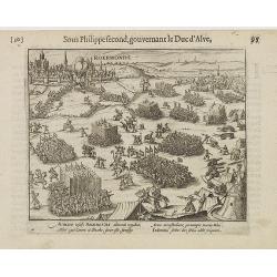
Auriaco infaelix Roermonda. . .
Showing the siege in May 1572 of Roermond.
- $100 / ≈ €86
Date: Amsterdam, 1612
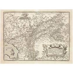
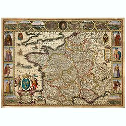
Provinciae, Regionis Galliae, vera exactissimaq. descriptio. Provence Petro Ioanne Bomparioo auctore.
A finely engraved map of the Province prepared by Pierre-Jean de Bompar who published a single sheet map of the Province in 1591. Title cartouche in the upper left-hand c...
- $500 / ≈ €432
Date: Amsterdam, 1613
![[Title page for] Galliae tabule geographicae . . .](/uploads/cache/47941-250x250.jpg)
[Title page for] Galliae tabule geographicae . . .
Very fine title page by Gerard Mercator, composed of an elaborate strapwork design with the portrait of a King at the top.
Date: Amsterdam, 1613
![[Title page colored by Georg Mack Jr. to : Hortus Eystettensis, Sive Diligens et Accurata Omnium Plantarum, Florum, Stirpium,. . .]](/uploads/cache/39343-250x250.jpg)
[Title page colored by Georg Mack Jr. to : Hortus Eystettensis, Sive Diligens et Accurata Omnium Plantarum, Florum, Stirpium,. . .]
Title page to the first edition, one of about 300 copies printed, from one of the largest and most magnificent of the great flower books, depicting more than 1000 flowers...
Date: Nuremberg, ca 1613
![Description de tovts les Pays-Bas, autrement appellez, la Germanie Inferieure, ov Basse Allemagne / par Messire Loys Gvicciardin [...]](/uploads/cache/48781-250x250.jpg)
Description de tovts les Pays-Bas, autrement appellez, la Germanie Inferieure, ov Basse Allemagne / par Messire Loys Gvicciardin [...]
Fine early edition of the French oblong edition of this famous description of the Low Countries. For the French edition most plates are newly engraved by Petrus Kaerius.....
- $3500 / ≈ €3021
Date: Arnhem, Janssonius, J.,1613
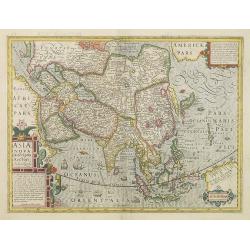
Asiae Nova Descriptio. . .
Several sources appear to have been used in the compilation of this map, including the Portuguese Jesuits Luis Teixeira (1595) for Japan, and Luis Jorgede Barbuda (1584) ...
- $3000 / ≈ €2590
Date: Amsterdam, 1613
![[Titlepage] Italiae, Sclavoniae, et Graeciae tabula geographice..](/uploads/cache/21220-250x250.jpg)
[Titlepage] Italiae, Sclavoniae, et Graeciae tabula geographice..
The text in this decorative title page from the atlas by Mercator is enclosed in an architectural framework engraved with cherubs, garlands and an eagle.Read more about t...
- $220 / ≈ €190
Date: Amsterdam, 1613
![[Titlepage] Galliae tabulae geographicae..](/uploads/cache/21219-250x250.jpg)
[Titlepage] Galliae tabulae geographicae..
Decorative title page from the atlas by Mercator, surrounded with strapwork designs, garlands, fruit, birds and a portrait of a king.Read more about title pages. [+]
- $220 / ≈ €190
Date: Amsterdam, 1613

Nova et accurata Foederatarum Orovinciarum Inferioris Germaniae descriptio… 1615 P.Kaerius.
The oldest know map of the Dutch Republik. The extremely rare 1615 editiion of the map of the Netherlands. The map is better from from the Cloppenburg editions of the At...
- $1500 / ≈ €1295
Date: J.Janssoius, Arnhem, 1615
De Christiana expeditione apud Sinas suscepta ab Societate Jesu, ex P. Matthaei Ricci.
Very rare first edition of the most influential Western description of China since the 13th-century account by Marco Polo. Printed in Latin with an engraved title page in...
Date: Augustæ Vind. (Augsburg), C. Mangium, 1615
Aufzug des durchleuchtigsten hochgebornen Fürsten und Herren, Herren Friderichen Pfaltzgrafen bey Rhein.. .
Finely executed engraving by Matthäus Merian, taken from "Aufzug des durchleuchtigsten hochgebornen Fürsten und Herren, Herren Friderichen Pfaltzgrafen bey Rhein. ...
Date: Hulsen, Stuttgart, 1616
Gallia. Nova Galliae descriptio . . .
Very rare and early map of France with figures on three sides with views of cities, portraits (Henri IV and Marie de Medicis) and costumes. The map was directly influence...
Date: Amsterdam, 1616
Aufzug des durchleuchtigsten hochgebornen Fürsten und Herren, Herren Friderichen Pfaltzgrafen bey Rhein.. .
Finely executed engraving by Matthäus Merian, taken from "Aufzug des durchleuchtigsten hochgebornen Fürsten und Herren, Herren Friderichen Pfaltzgrafen bey Rhein. ...
- $100 / ≈ €86
Date: Hulsen, Stuttgart, 1616
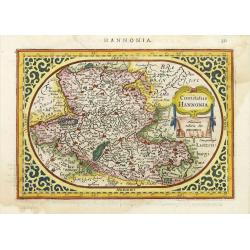
Comitatus Hannonia.
Detailed map of the Belgium province Hainault or Henegouwen. Including the towns of Mons, Geraadsbergen, etc.Uncommon and decorative oval map in a rectangular frame, the ...
- $100 / ≈ €86
Date: Amsterdam, 1616
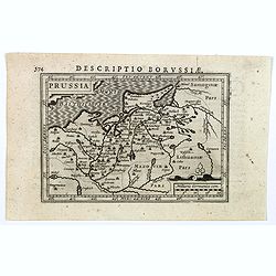
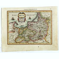
Descriptio Borussiae.
Fine miniature map of Prussia, now-a-day Poland. Bertius was a Flemish theologian, historian, geographer and cartographer. This little copperplate gem was engraved by van...
- $150 / ≈ €129
Date: Amsterdam, 1616

Nieuw Nederlandtsch Caertboeck. Waer in volkomentlijcker als oyt te voren vertoont werden de XVII. Nederlanden.
Rare first edition of this atlas of the provinces of the Netherlands, Belgium and Luxemburg. Engraved title page, with : "Gedruckt t' Amsterdam by Abraham Goos Plaet...
Date: Amsterdam, 1616
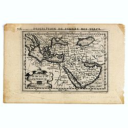
Turicum imperium.
FIRST IMPRINT FROM THE NEWLY ENGRAVED PLATES IN 1616. - A rare miniature map of the Ottoman empire with Turkey and the Arabian Peninsular. Title cartouche on the lower le...
Date: Amsterdam, J. Hondius, 1616
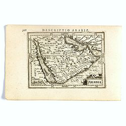
Arabia.
FIRST IMPRINT FROM THE NEWLY ENGRAVED PLATES IN 1616. - A rare miniature map of the Arabian Peninsular. Title cartouche on the lower left corner.First published in 1598 i...
Date: Amsterdam, J. Hondius, 1616
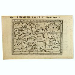
Russia.
Centered on Moscow, with the southern reaches of the map showing Persia, Armenia and Tashkent, the Black and Caspian Seas, and northward to Lapland and the frozen arctic ...
- $200 / ≈ €173
Date: Amsterdam, 1616
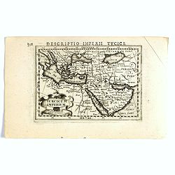
Turcicum Imperium.
FIRST IMPRINT FROM THE NEWLY ENGRAVED PLATES IN 1616. - A rare miniature map of the Arabian Peninsular. Title cartouche on the lower left corner.First published in 1598 i...
- $500 / ≈ €432
Date: Amsterdam, J. Hondius, 1616
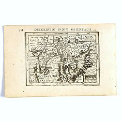
India Orientalis.
FIRST IMPRINT FROM THE NEWLY ENGRAVED PLATES IN 1616. - A rare miniature map of the East Indies.First published in 1598 in his Caert-Thresoor, the plates were executed by...
Date: Amsterdam, J. Hondius, 1616
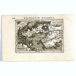
Malacca.
FIRST IMPRINT FROM THE NEWLY ENGRAVED PLATES IN 1616. - A rare miniature map of Malacca, Borneo, part of Sumatra . Latin text on verso.First published in 1598 in his Caer...
Date: Amsterdam, J. Hondius, 1616
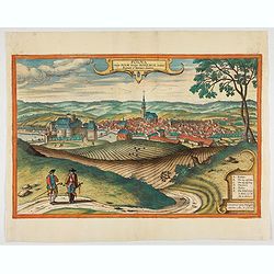
Polna vulgo Polm insign : Bohemia. . .
This is a view of Polna from the southwest, looking across the Bohemian-Moravian Highlands from a slightly elevated viewpoint. In addition to the parish church (D) in the...
Date: Cologne, 1617
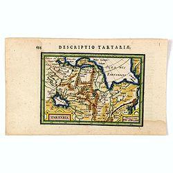
Tartaria.
An original early 17th century copper engraved miniature antique map of Tartary, China and part of America by Petrus Bertius.The title is displayed in a strap work cartou...
- $150 / ≈ €129
Date: Amsterdam, J.Hondius, 1618
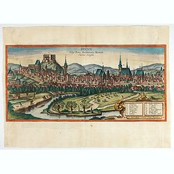
Brunn Vulgo Brinn Marchionatus Moraviae Civitas insignis.
Fine view of Brno seen from the southeast. TRANSLATION OF CAPTION: Brunn, in the vernacular Brno, eminent city in the Margravate of Moravia.COMMENTARY BY BRAUN: "Brn...
- $500 / ≈ €432
Date: Cologne, 1618
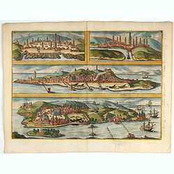
Casablanca (Anfa) - Azemmour (Azamor) - Diu - Old Goa (Velha Goa)
Four fine coastal views of these harbors cities which were important to Portuguese trade. Goa and Diu on the western coast of India, together with Anfa (Casablanc) and Az...
- $450 / ≈ €388
Date: Cologne, 1618
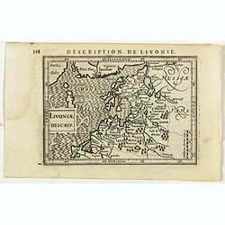
Livoniae Descrip.
A rare miniature map of the Baltic States Estonia, Latvia & Lithuania. The present map is one of the earliest obtainable maps to focus this region. Title cartouche o...
- $200 / ≈ €173
Date: Amsterdam, 1618
!['T Derde deel van 't Licht der zee-vaert, inhoudende de beschryvinghe der zeecusten van de Middelandtsche Zee /, By een vergaedert ende in't licht ghebracht door Willem Janssen. [Blaeu sea atlas].](/uploads/cache/49048-250x250.jpg)
'T Derde deel van 't Licht der zee-vaert, inhoudende de beschryvinghe der zeecusten van de Middelandtsche Zee /, By een vergaedert ende in't licht ghebracht door Willem Janssen. [Blaeu sea atlas].
Extremely rare W. Blaeu's Sea Atlas describing the coasts and islands of the Mediterranean Sea, published in Amsterdam by W. Blaeu" Tot Amsterdam, by Willem Jansz. ...
- $150000 / ≈ €129480
Date: Amsterdam, 1618
