Browse Listings in Europe
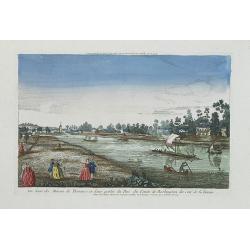
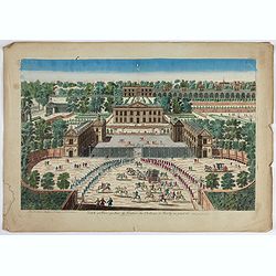
Vue d'une des Maison de Plaisance et d'une partie du Parc du Comte de Burlington du Coté de la Tamise.
A so-called optical print of Burlington County and the River Thames. Published by the brothers Chéreau, active in Paris at rue St. Jacques au dessus de la Fontaine St. S...
- $225 / ≈ €194
Date: Paris, 1760
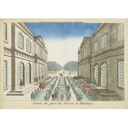
Entree du parc du Prince à Manheim.
Perspective view of the Royal Park in Manheim by Basset, a well-known publisher of optical prints, established in rue St.Jacques in Paris. With a brief key list.In the ei...
- $75 / ≈ €65
Date: Paris, 1760
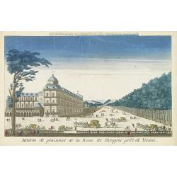
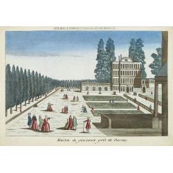
Maison de plaisance de la reine de Hongrie pres de Vienne.
Perspective view of the castle of the queen of Hungary near Vienna. Basset was a well-known publisher of optical prints, established in rue St.Jacques in Paris. With brie...
Date: Paris, 1760
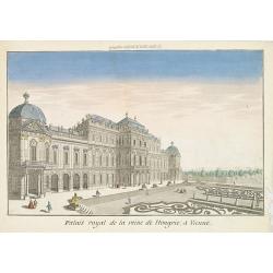
Palais royal de la reine de Hongrie à Vienne.
Perspective view of the royal palace of the queen of Hungry, in Vienna, a well-known publisher of optical prints, established in rue St.Jacques in Paris. With brief key l...
Date: Paris, 1760
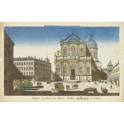
Eglise et place de Saint Andre dellavalle à Rome.
Perspective view of the church and place Sant'Andrea della Valle church in Rome. Sant'Andrea della Valle later became a model for the construction of other churches like ...
Date: Paris, 1760

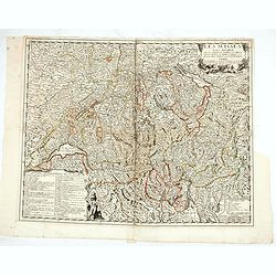
Belgica Foederata. . .
Decorated with a cartouche showing the coats of arms of Zeeland, Holland, Utrecht, Friesland, Groningen and Overijssel. T.C. Lotter married M. Seutter's daughter in 1740 ...
Date: Augsburg, ca.1760
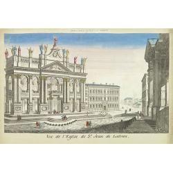
Vue de l'eglise de St Jean de Latran.
So-called optical print of the church Saint Jean de Latran, by Basset a well-known publisher of optical prints, established in rue St.Jacques in Paris. With brief key lis...
- $150 / ≈ €129
Date: Paris, 1760
Maison de plaisance près de Parme.
So-called optical print of a country house near Parma, by the well-known publisher of optical prints, Basset, established in rue St.Jacques in Paris.In the eighteenth and...
- $150 / ≈ €129
Date: Paris, 1760
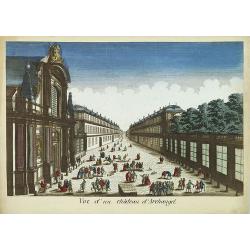
Vue d'un château d'Archangel.
So-called optical print of a street and house in Arkhangelsk, by the well-known publisher of optical prints, Basset, established in rue St.Jacques in Paris. In the eighte...
- $300 / ≈ €259
Date: Paris, 1760

6e Vüe d'Optique Représentant Le Chœur de la Cathedrale de St. Paul de Londres.
So-called optical print illustrating a perspective view of the interior of the Saint Paul Cathedral in London.In the eighteenth and nineteenth centuries there were many p...
Date: Paris, 1760

5e Vue d'Optique Representant La Vue interieure de la Cathedralle de St. Paul de Londres.
So-called optical print illustrating a perspective view of the interior of the Saint Paul cathedral in London. Engraved by la Marcade.In the eighteenth and nineteenth cen...
Date: Paris, 1760
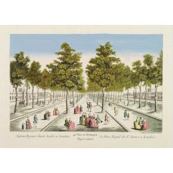
40e Vue d'Optique Representant Le Parc Royal de St. James a Londres.
So-called optical print illustrating a perspective view of Saint James Park, in London.In the eighteenth and nineteenth centuries there were many popular speciality estab...
- $250 / ≈ €216
Date: Paris, 1760

39e Vüe d'Optique Representant L'Hotel du Lord Maire de Londre.
So-called optical print illustrating a perspective view of Somerset House on the Strand in London.In the eighteenth and nineteenth centuries there were many popular speci...
Date: Paris, 1760

26e Vüe d'Optique Representant L'Abbaye de Westminster et de l'Eglise Ste. Marguerite à Londres.
So-called optical print illustrating a perspective view of the Westminster Abbey, in London.In the eighteenth and nineteenth centuries there were many popular speciality ...
Date: Paris, 1760

Vuë du dedans de l'Eglise de St. MARTIN à Londre.
So-called optical print illustrating a perspective view of the central aisle of St. Martin's church, in London.In the eighteenth and nineteenth centuries there were many ...
Date: Paris, 1760

Vüe Perspective du Pont neuf construit sur la tamise a Hampton-Court.
So-called optical print illustrating a bridge on the river Thames at Hampton-Court.In the eighteenth and nineteenth centuries there were many popular speciality establish...
Date: Paris, 1760
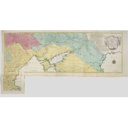
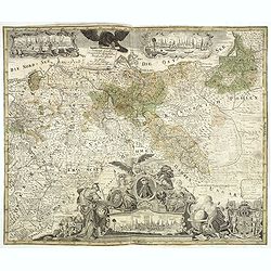
![Partie septentrionale du cercle de Haute Saxe [...] Brandebourg.](/uploads/cache/64110-250x250.jpg)
Partie septentrionale du cercle de Haute Saxe [...] Brandebourg.
Finely and crisply engraved map of north eastern part of Germany, including part of Poland. With inset map of Brandenburg. Map by Giles Didier Robert De Vaugondy with era...
- $150 / ≈ €129
Date: Paris, c. 1760
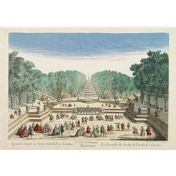
77e Vüe d'Optique Représentant Les Cascades du Jardin de Vauxhall a Londres.
So-called optical print illustrating a perspective view of the fountains and artificial cascades in Vauxhall Gardens, London.In the eighteenth and nineteenth centuries th...
Date: Paris, 1760
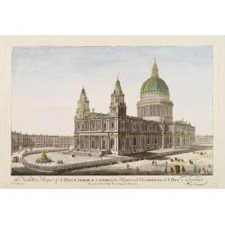
The North West Prospect of S. Pauls Cathedral in London.
Uncommon optical print illustrating a view of St. Paul's Cathedral in London.In the eighteenth and nineteenth centuries there were many popular speciality establishments ...
- $275 / ≈ €237
Date: Paris, 1760

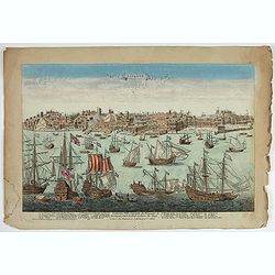
A view of Amsterdam taken from the Old Rampart.
So-called optical print of Amsterdam, published by Jean Mondhare after a print by Laurie and Wtitle. With captions in English and French above and belowIn the eighteenth ...
Date: Paris, ca. 1760
![Partie septentrionale du cercle de Haute Saxe [...] Brandebourg.](/uploads/cache/33211-250x250.jpg)
Partie septentrionale du cercle de Haute Saxe [...] Brandebourg.
Finely and crisply engraved map of north eastern part of Germany, including part of Poland. With inset map of Brandenburg. Map by Giles Didier Robert De Vaugondy with era...
Date: Paris, c. 1760
Carte géographique représentant le théâtre de la guerre entre les Russes, les Turcs et les Polonois confédérés. . .
Interesting and rare map showing the area of the Russo-Turkish Wars. To the right a large title cartouche and extensive text describing the different stages and the Wars ...
- $1500 / ≈ €1295
Date: Augsburg, 1760
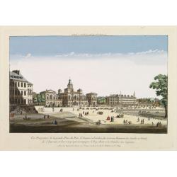
Vüe Perspective de la grande Place du Parc St. Jacques à Londres, du nouveau Batiment des Gardes a Cheval, de l'Amirauté..
So-called optical print illustrating a cortege of subjects accompanying the king to the House of Lords along the Horse guards Road in St. James's Park, in London.The Old ...
- $200 / ≈ €173
Date: Paris, 1760
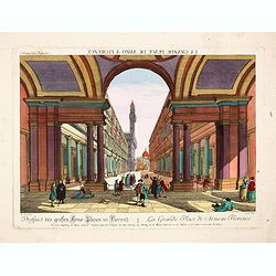
Prospect des grossen Arno Platzes in Florenz.
Rare so-called optical print illustrating a Street scene in Florence with the Palazzo Vecchio (town hall) and its Duomo (cathedral) in the background. Engraved by Balth F...
- $250 / ≈ €216
Date: Augsburg, 1760
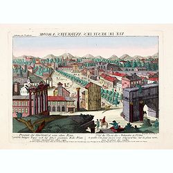
Prospect der Überbleibssel von altem Rome. - Vue du Reste des Antiquites a Rome.
A rare so-called optical print illustrates Roman Forum, ancient Rome's showpiece center, a grandiose district of marble-clad temples, proud basilicas and vibrant public s...
- $250 / ≈ €216
Date: Augsburg, 1760
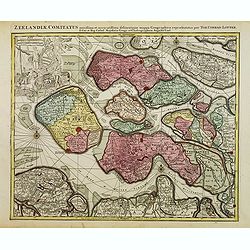
Zeelandiae Comitatus. . .
Scarce map of Zeeland, this is the state published by Tobias Conrad Lotter, previously published by Matthäus Seutter.Impressive cartouche with coat of arms of Zeeland to...
Date: Augsburg, c.1760
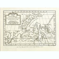
Carte des Païs habités par les Samojedes et Ostiacs, pour l'histoire générale des voyages.
Map shows Nova Zembla and the area of northern Russia that was inhabited by the Samoyeds and Ostiacs.Prepared by Jacques Nicolas Bellin after Dutch sources and included i...
- $75 / ≈ €65
Date: Paris, 1760
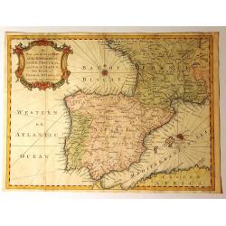
A New and Accurate Map of the Kingdoms of Spain, Portugal and Part of France, The Islands of Majorca, Minorca &c.
Produced for “Universal Magazine” by J. Hinton. It was engraved by Richard William Seale (1703-1762). The map features an attractive rococo cartouche and compass ros...
Date: London, ca. 1760
Vue et Perspective de la Trinité a Vienne.
Decorative perspective view of a square in Vienna centered on the column which represents the Trinity. Published by Jacques François Chereau [1742 -1794], who was active...
- $200 / ≈ €173
Date: Paris, 1760
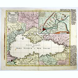
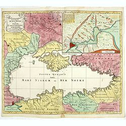
Nova Mappa Maris Nigris et Freti Constantinopolitani...
Map of the Black Sea with the Crimea and adjacent countries, inset map of the Bosporus with Constantinople at upper right.T.C. Lotter married M. Seutter's daughter in 174...
- $600 / ≈ €518
Date: Augsburg, ca. 1760
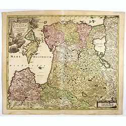
Dvcatvvm Livoniae et Cvrlandiae cum vicinis insulis nova exhibitio geographica.
A very attractive of Livonia, Estonia, Curlandia and the Baltic coast, which also includes the Gulf of Livonia or Riga.
- $500 / ≈ €432
Date: Nuremberg, 1760
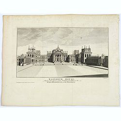
Blenheim House.
An attractive view of the front of Blenheim House (now Palace) home to the present 12th Duke and Duchess of Marlborough. The house was begun in 1705, built by Sir John Va...
- $50 / ≈ €43
Date: London, ca. 1760
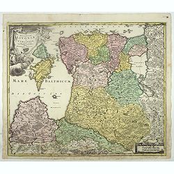
Dvcatvvm Livoniae et Cvrlandiae cum vicinis insulis nova exhibitio geographica.
A very attractive of Livonia, Estonia, Curlandia and the Baltic coast, which also includes the Gulf of Livonia or Riga.
- $450 / ≈ €388
Date: Nuremberg, 1760
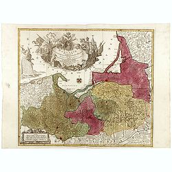
Borussiae Regnum compectens Circulos Sambiensem, Natangiensem, et Hockerlandiae Nee non Borussia Polonica, exhibens Palatinatus Culmiensem. . .
Decorative map covering northern Poland with Prussia, Pomerania, Hockerlandia, Warmiaermelandia, Natanglensis, Galindia, Nandrovia, Sclavonia, and the Baltic Sea. Include...
- $400 / ≈ €345
Date: Augsburg, ca. 1760
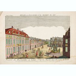
Prospect des Rossmarcktes zu Statin - Vue du Marché aux Cheveaux a Stettin.
Rare so-called optical print illustrating the Horse market of Stettin in Poland. Engraved by F. Riedel. The Academie Imperiale was a well-known publisher of optical print...
- $600 / ≈ €518
Date: Augsburg, 1760
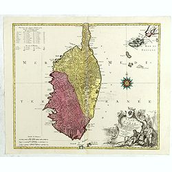
L'isle de Corse avec les différents districts, appartenante à la République de gênes . . .
Map published during the uprising of the Corsican people against the Republic of Genoa. It is decorated with a wind rose compass and a beautiful title cartouche decorated...
Date: Augsburg, 1760
Generale Carte der gesamten Koniglichen Preussischen Lander. . .
Beautiful and rare two sheet map of Prussia. The title cartouche is hold by a crowned eagle. In lower part a large baroque cartouche with allegorical figures and a portra...
- $1200 / ≈ €1036
Date: Berlin, 1760
Nova Mappa Maris Nigri et Freti Constantino Politani. . .
Decorative and uncommon map the Black Sea region. In upper left hand corner an inset map (200 x 280mm) of the Bosporus including Istanbul. Title engraved onto a drape-sty...
- $450 / ≈ €388
Date: Augsburg, ca. 1760
Les Suisses leurs sujets et leurs alliez. . .
Un uncommon map of Switzerland by Nolin.
- $250 / ≈ €216
Date: Paris, ca. 1760
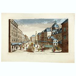
Lisbone Ville Capitale du Royaume de Portugal…
A very RARE panoramic view of the city of Lisbon, including a numbered legend in the lower part : 1-28.The plate, at the joint address of Esnault et Rapilly and Daumont,...
Date: Paris, c. 1760
Veuë et Pers-pective de l'Entrée du Château de Marly en général.
A rare panoramic view of the Château de Marly (Marly-le-Roi) by Aveline. The plate, at the joint address of Esnault et Rapilly and Daumont, is numbered in upper right co...
- $250 / ≈ €216
Date: Paris, c. 1760

Nieuwe Paskaart van het Westerlykste Gedeelte van HET KANAAL strekkende aan de ENGELSCHE KUST van Poortland tot de Sorlinges. . .
Nieuwe Paskaart van het Westerlykste Gedeelte van HET KANAAL strekkende aan de ENGELSCHE KUST van Poortland tot de Sorlinges en aan de Fransche kust van het Eylandt Guern...
- $900 / ≈ €777
Date: Amsterdam, 1760

Gesigt van den Vermaakelyken Overtoom ... der stad Amsterdam....
A view of the Overtoom in the eighteenth century. Etching on two joined sheets of paper, after A.Rademaker. By the eighteenth century, numerous country villas had been bu...
Date: Amsterdam, 1760

Pagus Helvetiae Abbatiscellanus .. Valle Rhenana. . .
Scarce. A splendid map of the Swiss Alps, the area south west of the Boden See and west of the River Rhine, centered on Appenzell, St. Gallen. Engraved by Tobias C. Lotte...
- $800 / ≈ €691
Date: Augsbourg, 1760

Belgium Foederatum auctius et emendatius edit..
Map of the northern part of the Netherlands. With a decorative title cartouche, with an inset map of South East Asia.
Date: Augsburg 1760

Vue perspective de la Galerie Royale de Copenhague conduisant au Jardin.
So-called optical print illustrating a perspective view of the Royal Portico in Copenhagen.Mondhare was a well-known publisher of optical prints, established in Paris. In...
Date: Paris 1761

Vue de la superbe Gallerie de Petersbourg en Russie.
So-called optical print illustrates a perspective view of the interior of a palace in Saint Petersburg.Mondhare was a well-known publisher of optical prints, established ...
- $200 / ≈ €173
Date: Paris, 1761

Pianta Geografia delle Isole di Malta, e Gozo della Sagra Religione Gerosolimitana di S. Giovanni delineata, ed incisa in quest anno 1761.
A rare map of Malta and Gozo printed by the priest Antonio Bova (1688 - 1775), who was active as engraver in Palermo ca. 1727-1773. He produced cartographic engravings, s...
Date: Bova Ant., Palermo, 1761
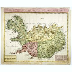
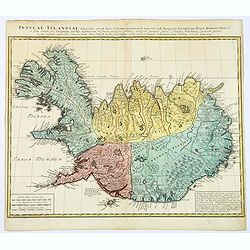
Insulae Islandiae delineatio : prout haec Solenni mensurandi negotio sub Auspiciis Potensissimi Regis Daniae facto . . .
Detailed and important map of Iceland, prepared by Th. H. Knoff and O. Ranzow and published by the Homann Heirs. The map is more scientific than many previous similar ver...
- $850 / ≈ €734
Date: Nuremberg, 1761
Insula Islandiae delineatio. . .
A nice large map of Iceland published by Homann Heirs. The country is divided up into four differently colored regions, lettered title to top of map, boxed mileage scales...
- $900 / ≈ €777
Date: Nuremberg, 1761
Le Comté de Tirol, les Evèchés de Trente et de Brixen..
Detailed map of Austria showing territories of Tyrol, Bavaria, Brixen. Engraved by Cordier.
Date: Paris, 1761
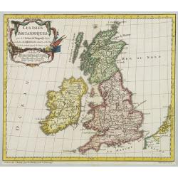
Les Isles Britanniques..
A first state (of 2) dated 1762. Fine map of the British Isles, engraved by E.Dussy. Fine title cartouche upper left engraved by Arrivet. From his Nouvel Atlas Portatif .
Date: Paris, 1762
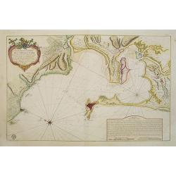
Carte Hydrographique De La Baye De Cadix. . .
Beautiful chart of the Bay of Cadiz, from Rota to Cadiz, with dramatic coastal topography, soundings, anchorages, forts, loxodromic lines, compass rose and large decorati...
Date: Paris, 1762
![[Mer Baltique]](/uploads/cache/37796-250x250.jpg)
[Mer Baltique]
Detailed map of Northern part of Poland with Danzig, from his "Atlas moderne ou collection de cartes...".map N° 15.
- $300 / ≈ €259
Date: Paris, 1762
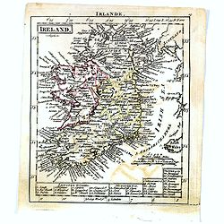
Ireland.
Uncommon miniature map of Ireland, engraved by J. Bayly for "A New General and Universal Atlas Containing Forty five Maps by Andrew Dury".This miniature atlas p...
- $50 / ≈ €43
Date: London, 1761-1763
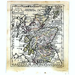
A map of Scotland.
Uncommon miniature map of Scotland, engraved by Thomas Kitching for "A New General and Universal Atlas Containing Forty five Maps by Andrew Dury".This miniature...
- $50 / ≈ €43
Date: London, 1761-1763
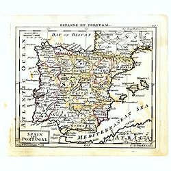
Spain and Portugal.
Uncommon miniature map of Spain and Portugal, engraved by Thomas Kitching for "A New General and Universal Atlas Containing Forty five Maps by Andrew Dury".This...
- $60 / ≈ €52
Date: London, 1761-1763
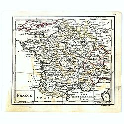
France.
Uncommon miniature map of France, engraved by J.Spilbury for "A New General and Universal Atlas Containing Forty five Maps by Andrew Dury".This miniature atlas ...
- $50 / ≈ €43
Date: London, 1761-1763
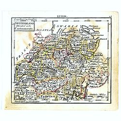
Switzerland divided into Cantonments.
Uncommon miniature map of Switzerland, engraved by Thomas Kitching for "A New General and Universal Atlas Containing Forty five Maps by Andrew Dury".This miniat...
- $30 / ≈ €26
Date: London, 1761-1763
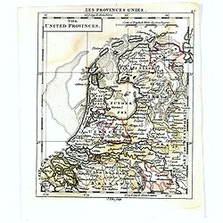
The United Provincies.
Uncommon miniature map of The Netherlands, engraved by J.Ellis for "A New General and Universal Atlas Containing Forty five Maps by Andrew Dury".This miniature ...
- $50 / ≈ €43
Date: London, 1761-1763
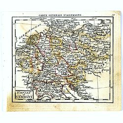
Empire of Germany.
Uncommon miniature map of Germany, Poland, the Low Countries and Eastern Europe, engraved by Thomas Kitching for "A New General and Universal Atlas Containing Forty ...
- $40 / ≈ €35
Date: London, 1761-1763
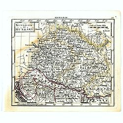
Kingdom of Hungary.
Uncommon miniature map of Hungary, engraved by Thomas Kitching for "A New General and Universal Atlas Containing Forty five Maps by Andrew Dury".This miniature ...
- $75 / ≈ €65
Date: London, 1761-1763
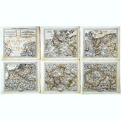
The Empire of Germany.
Uncommon miniature map in six sheets of the Empire of Germany, engraved by Thomas Kitching for "A New General and Universal Atlas Containing Forty five Maps by Andre...
- $75 / ≈ €65
Date: London, 1761-1763
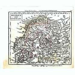
Sweden and Norway.
Uncommon miniature map of Sweden and Norway, engraved by Thomas Kitching for "A New General and Universal Atlas Containing Forty five Maps by Andrew Dury".This ...
- $75 / ≈ €65
Date: London, 1761-1763
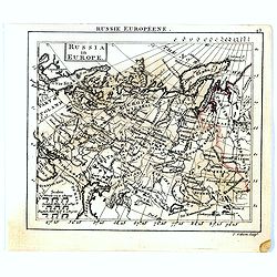
Russia in Europe.
Uncommon miniature map of Russia, engraved by Thomas Kitching for "A New General and Universal Atlas Containing Forty five Maps by Andrew Dury".This miniature a...
- $75 / ≈ €65
Date: London, 1761-1763
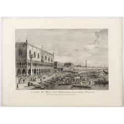
A minore D: Marci Area Dalmatarum ripam.
A minore D: Marci Area Dalmatarum ripam". View of the Riva degli Schiavoni from the east including the Palazzo Ducale in the foreground. Apud Ludovicum Furlanetto su...
Date: Venice, c. 1763
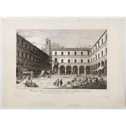
Prospectus Plateae et Ecclesiae Sancti Jacobi prope Pontem Rivi alti.
Prospectus Plateae et Ecclesiae Sancti Jacobi prope Pontem Rivi alti". The Church of San Giacomo di Rialto, at right Palazzo dei Dieci and the bridge of Rialto.From ...
Date: Venice, c. 1763
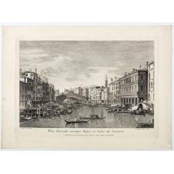
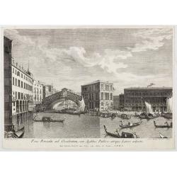
Pons Rivoalti, utriumqque Ripae, et Aedes ad Orientem.
Pons Rivoalti, utriumqque Ripae, et Aedes ad Orientem." From the series "Prospectum Urbis Venetiarum" (Views of Venice). 1st state. Published by Lodovico F...
Date: Venice, 1763
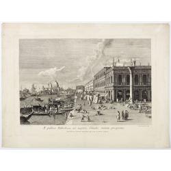
A publica Bibliotheca ad majoris Canalis initium prospectus.
A publica Bibliotheca ad majoris Canalis initium prospectus". View of the Biblioteca Nazionale Marciana, the column of San Teodoro at right, at left the Grand Canal,...
Date: Venice, 1763
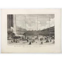
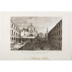
Qua late patet S. Marci area major novum Regim Palatium versus.
Qua late patet S. Marci area major novum Regim Palatium versus". View of piazza San Marco, the church of San Geminiano at the far end, figures and market stalls in t...
Date: Venice, 1763
Pons Rivoalti ad Occidentem, cum Aedibus Publicis utrique Lateri adjectis.
Pons Rivoalti ad Occidentem, cum Aedibus Publicis utrique Lateri adjectis."From the series "Prospectum Urbis Venetiarum" (Views of Venice). 1st state. Publ...
Date: Venice, 1763
Prospectus Plateae ad Divum Iacobum de Rivoalto ubi Mercatores conveniunt.
Prospectus Plateae ad Divum Iacobum de Rivoalto ubi Mercatores conveniunt. From the series "Prospectum Urbis Venetiarum" (Views of Venice). Published by Lodovic...
Date: Venice, c. 1763
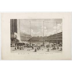
Qua late patet S. Marci area major novum Regim Palatium versus.
Qua late patet S. Marci area major novum Regim Palatium versus". View of piazza San Marco, the church of San Geminiano at the far end, figures and market stalls in t...
Date: Venice, 1763
![[56] I.Scio.](/uploads/cache/12828-250x250.jpg)
[56] I.Scio.
"Charming chart of the harbour of the Greek town of Chios. Showing town and harbour plan, with soundings, anchorages, rocks, shoals, fortifications and lighthouses.J...
- $80 / ≈ €69
Date: Marseille, 1764
![[59] Svr I. De Paros.](/uploads/cache/12831-250x250.jpg)
[59] Svr I. De Paros.
Charming chart of the harbour of the Greek island of Paros. Showing town and harbour plan, with soundings, anchorages, rocks, shoals, fortifications and lighthouses.Josep...
- $50 / ≈ €43
Date: Marseille, 1764
![[60] Porto de Ganea.](/uploads/cache/12832-250x250.jpg)
[60] Porto de Ganea.
Charming chart of the harbour of the Greek town of Ganea. Showing town and harbour plan, with soundings, anchorages, rocks, shoals, fortifications and lighthouses.Joseph ...
Date: Marseille, 1764

Ajustement des Femmes de Valday Situé entre Petersbourg et Moscou.
Etching by Jean-Baptiste Le Prince (1734-1781), from "2me Suite de divers cris de marchands de Russie", showing typical russian customs. The sketches Le Prince ...
- $110 / ≈ €95
Date: Paris, 1764
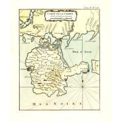
Carte de la Crimée.
Fine map of Crimea (Ukraine) here in the only issue of this version of Bellin's map, slightly larger than the common version. From Bellin's Le Petit Atlas Maritime Recuei...
Date: Paris, 1764

Het stadhuis, van vooren.
The former Amsterdam Town Hall, now the Royal Palace. Copper engraving by Frans de Bakker after Reinier Vinkeles (1741-1816).From the well-known description of Amsterdam ...
Date: Amsterdam, 1765
Nouvelle carte géographique des postes et autres routes d'Allemagne. . .
Map showing the northern provinces in Germany and part of the Netherlands. Decorative title cartouche in the upper left corner. A so-called post road maps.
- $80 / ≈ €69
Date: Paris, 1766