Browse Listings
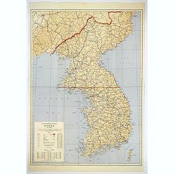
Official War map of Korea.
A large folding map of Korea published in the year of the outbreak of the Korean War, published by the Rand McNally Company. The map is extremely detailed and features a ...
Place & Date: America, ca 1950

L'Homme A La Boule.
Satirical print in which Count Otto von Bismarck balances on the world with one spurred foot entering France, and wearing only his underpants which are marked with the Ge...
Place & Date: Paris, 1870-1871

Circoscrizione delle Provincie ecclesiastiche e Diocesi nei regni del Belgio, ed Olanda (Tav LXI)
This large-format map showing Belgium and Holland with its different dioceses. The map is finely engraved and beautifully colored and was prepared by Girolamo Petri, a la...
Place & Date: Rome, 1858

London in Miniature With The Surrounding Villages. An Entire New Plan In which the Improvements both present and intended are actually reduced, by permission, from the surveys of the Several Proprietors. . .
Hand-coloured engraved map, dissected and mounted on linen, orange publishers label on one side, extending west to east from Kensington to East India and Greenwich Dock a...
Place & Date: London, 1821

Voyage of his majesty’s ship Alceste, along the Coast of Corea, to the island of Lewchew, with an account of her subsequent shipwreck, by John M’LEOD. Surgeon of the Alceste.
Second and best edition, with frontispiece portrait of Captain Maxwell and five fine hand-colored aquatint plates, including a plate not present in the first edition of t...
Place & Date: London, John Murray, 1818

Novus de Leone Belgico eiusq topographia atq. Historica descriptione liber (…). Rerumque in Belgio maxime gestarum, inde ab anno Christi M.D.LIX. Usque ad annum M.D.LXXXVII perpetua narratione continatus.
ENLARGED EDITION, with 207 (of 208) engravings of a famous eyewitness account of the Dutch Revolt, with the famous "Leo Belgicus" map, here in its second state...
Place & Date: Cologne, Gerardus Campensis for Frans Hogenberg, 1588
Carte Generalles des Royaumes & Provinces, de la haute et basse Allemagne, Reveües et Corigées, par le Sr. Tassin, Geographe Ordinaire de Sa Ma.té.
Illustrated with 51 (of 52) maps of The Netherlands, Belgiem, Germany, France, Poland, Bohemia...Christophe Tassin, who was active from 1633 till 1655, was appointed 'roy...
Place & Date: Paris, [Sébastien Cramoisy], 1633

Slusa, Teutonicae Flandriae opp. . . (Sluis)
Bird'eye view of the town of Sluis.From the greatest publication in this genre!. The Civitates was compiled and written by George Braun, Canon of Cologne Cathedral. Braun...
Place & Date: Cologne, 1580

Germaniae Nova ac Accurata Descriptio.
This "carte à figures"- map covers the Low Countries, Germany, Poland, Switzerland and Austria. Overall a very good copy of this excellently engraved, uncommon...
Place & Date: Amsterdam, 1642

Siberia & Central Asia.
This map covers the eastern section of Russia as well as China, Japan, Korea, India and Tibet. The map is of interest for the use of Sea of Corea, the sea between Korea a...
Place & Date: Boston, 1835

Kaartje van Asia. . .
Attractive and rare map of Asia. From Atlas Portatif . With a curious and oversized Hokkaido. The map is of interest for the use of Coreanse Zee for the sea between Korea...
Place & Date: Deventer 1742

The Russian Empire in Europe and Asia . . .
Detailed map of the whole of Russia, extending from Poland to the Pacific and from Nova Zembla to Tartaria.The map is of interest for the use of Corea Gulf for the sea be...
Place & Date: London, 1790
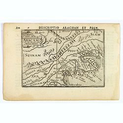
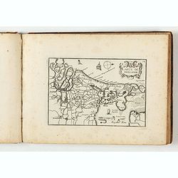
Aracam.
A rare miniature map of Thailand and Burma. Title cartouche on the upper left corner. First published in 1598 in his 'Caert-Thresoor', the plates were executed by the mos...
Place & Date: Amsterdam, 1606
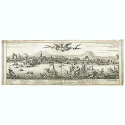
Candie.
A panoramic view, showing the Turkish siege of Candia, with a numbered key (1-33) at the bottom locating 33 points of interest. of Crete coast and the Turkish vessels (33...
Place & Date: Amsterdam, ca. 1678
![Candia [Map of the island Crete]](/uploads/cache/45233-250x250.jpg)
Candia [Map of the island Crete]
Very rare map of the island Crete published in the first edition of "Viaggio da Venetia, a Costantinopoli. Per Mare, e per Terra, & infieme quello di Terra Santa...
Place & Date: Venice, Giacomo Franco, 1598
![Rodi [View of Rhodes]](/uploads/cache/45236-250x250.jpg)
Rodi [View of Rhodes]
Very rare view of the City of Rhodes on the island of Rhodes. Historically, Rhodes island was very famous worldwide for the Colossus of Rhodes, one of the Seven Wonders o...
Place & Date: Venice, Giacomo Franco, 1598

Jerusalem.
Very rare view of Jerusalem published in the first edition of "Viaggio da Venetia, a Costantinopoli. Per Mare, e per Terra, & infieme quello di Terra Santa. Da G...
Place & Date: Venice, Giacomo Franco, 1598
![Namphio. [Map of Anafi]](/uploads/cache/45243-250x250.jpg)
Namphio. [Map of Anafi]
Very rare map of the island of Anafi Island published in the first edition of "Viaggio da Venetia, a Costantinopoli. Per Mare, e per Terra, & infieme quello di T...
Place & Date: Venice, Giacomo Franco, 1598
![Stampalia. [Map of Astypalaia]](/uploads/cache/45244-250x250.jpg)
Stampalia. [Map of Astypalaia]
Very rare map of the Greek island Astypalaia. The island is known in Italian as Stampalia. Published in the first edition of "Viaggio da Venetia, a Costantinopoli. P...
Place & Date: Venice, Giacomo Franco, 1598

L'Africa divisa nelle sue Parti secondo le pui moderne . . .
A beautiful and rare two-sheet map of Africa. The title cartouche is depicted on a drape surrounded by native animals.A most noticeable feature of the decoration on the m...
Place & Date: Venice, 1690
-250x250.jpg)
Israel.
Decorative poster advertising flights to Israel made by Georges Mathieu. The poster is one of a series of 15 composed of posters of Greece, Israel, Germany, Great Britai...
Place & Date: Paris, 1967
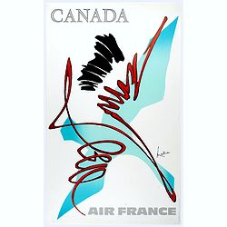
Canada.
Decorative poster advertising flights to Canada made by Georges Mathieu. The poster is one of a series of 15 composed of posters of Greece, Israel, Germany, Great Britai...
Place & Date: Paris, 1967

Hong Kong.
Decorative poster advertising flights to Hong Kong made by Georges Mathieu. The poster is one of a series of 15 composed of posters of Greece, Israel, Germany, Great Bri...
Place & Date: Paris, 1967
![[Two vomlumes, with two Leo maps] De Bello Belgico, Decas Prima / Decas Secunda.](/uploads/cache/48779-250x250.jpg)
[Two vomlumes, with two Leo maps] De Bello Belgico, Decas Prima / Decas Secunda.
With 2 engraved titles of the 'Leo Belgicus', with one paw resting on a shield bearing the title, large woodcut printer's device on the colophons, and 30 richly engraved ...
Place & Date: Rome, Franciscus Corbelletus, 1632-1647
![Amerique Septentrionale divisée en ses principales parties. . .1685. [California as an Island]](/uploads/cache/60628-250x250.jpg)
Amerique Septentrionale divisée en ses principales parties. . .1685. [California as an Island]
Engraved by Cordier. Spectacular example of Jaillot's map of North America, showing California as an Island, based upon Sanson's landmark map of 1656. This map shows the ...
Place & Date: Paris, 1685
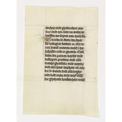
Manuscript leaf on vellum from a Dutch Book of Hours.
A leaf from a medieval manuscript Book of Hours, written in Utrecht.Fourteen lines of monastic Textura script with 4 two-line initial "I" in liquid gold on a bl...
Place & Date: Utrecht, ca.1450 - 1460
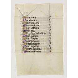
Manuscript leaf on vellum from a Dutch Book of Hours.
A leaf from a medieval manuscript Book of Hours, written in Utrecht.Fourteen lines of monastic Textura script with fourteen 1-line initials in blue or gold with extensive...
Place & Date: Utrecht, ca.1450 - 1460
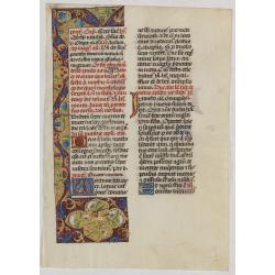
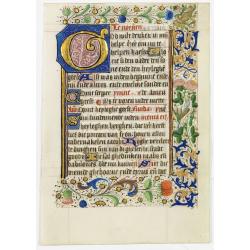
Leaf on vellum from a manuscript Brevier.
RECTO: One 3-line illuminated initial in burnished gold on colored grounds. Panel border of acanthus leaves, flowers and birds on a partly liquid gold and dark red ground...
Place & Date: Tours, c.1485

A new & accurate map of the Empire of China from the Sieur Robert's Atlas. With improvements.
An excellent early engraving of China and Korea that appeared in Sieur Robert de Vaugondy's Geographical Dictionary (London: 1759). Decorative title cartouche on the uppe...
Place & Date: London, 1759

Asia secundum legitimas projectionis stereographicae.
Highlighted area covers part of Spain, eastern coast of Ireland to western part of Papua New Guinea and the Asian continent from the Northern Polar Sea to the Indian Ocea...
Place & Date: Nurenberg, 1744

Carte de la Mer Rouge, depuis Moka jusqu's Gedda. . . .
Chart of the Red Sea. With 3 inset maps of Shake Omare, Goofs and Gedan. D'Après De Mannevillette (1707-1780) was one of France's first hydrographers. When the first edi...
Place & Date: Paris, 1753
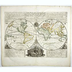
Mappe-Monde pour connoitre les progres & les conquestes..
Unusual double hemisphere map with California as an Island. Dutch text describes the expeditions and colonial possessions of the Dutch East India Company. The map origina...
Place & Date: Amsterdam, 1729
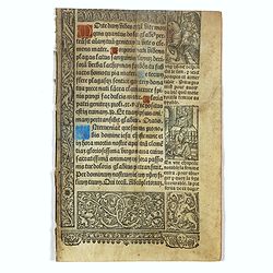
Leaf on vellum from a printed Book of Hours.
21 lines of printed text, surrounded by Renaissance borders decorated with flowers and little miniatures with figures on both sides.From the press of the leading Parisian...
Place & Date: Paris, Germain Hardouyn, c. 1520-1540
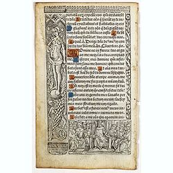
Leaf on vellum from a printed Book of Hours In Latin and French.
24 lines of printed text, surrounded by renaissance borders decorated with flowers, vases and figures. Gothic type, text in Latin, numerous one and two-line initials in g...
Place & Date: Paris, Germain Hardouyn, c. 1520-1540
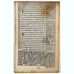
Leaf on vellum from a printed Book of Hours In Latin and French.
24 lines of printed text, surrounded by renaissance borders decorated with flowers, vases and figures. Gothic type, text in Latin, numerous one and two-line initials in g...
Place & Date: Paris, Germain Hardouyn, c. 1520-1540

Charte von China und den angränzenden Ländern und Völkerschaften so wie den letzten Kaiser Tschien-Long. . .
Uncommon map of China on a scale of ca. 1:6,000,000. The map's complete title is “Charte von China und den angränzenden Ländern, und Völkerschaften so wie sie dem le...
Place & Date: Parague, 1812
Selling price: $400
Sold in 2023
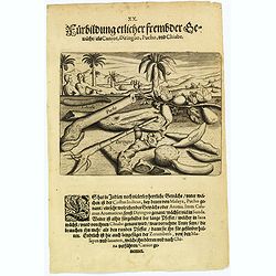
Plants, including the canior, diringuo, pucho and chiabe.
In the Indies there are many delightful plants, which include the ‘costus indicus’ (named by the Malays 'pucho') that has a wonderful aroma. Then there is the ‘cala...
Place & Date: Frankfurt, 1598
Leaf on vellum, from a manuscript book of hours.
Scatter border of flowers. Borders of very high quality, executed by an artist of the Ghent-Bruges school.VERSO: 19 lines of Dutch text in brown ink. A 6-lines capital &q...
Place & Date: Flanders, 1450

Asia By H.Moll Geographer.
Detailed map of Asia. From his "Atlas minor: or a new and curious set of sixty-two maps. . .", which was first published in 1729 and reprinted in 1732, 1736.The...
Place & Date: London, 1736

Carte des Isles du Japon Sequels est remarque la Route..
This uncommon map of Japan, a reduced version of his larger map, contains comments about the nature of the country. For instance, Ocsaqui (Okazaki, near Nagoya) is said t...
Place & Date: Paris / Amsterdam, 1679