Browse Listings
![[Albania, Bulgaria, Europe, Eastern, Greece, Hungary, Macedonia, Romania]](/uploads/cache/33868-250x250.jpg)
[Albania, Bulgaria, Europe, Eastern, Greece, Hungary, Macedonia, Romania]
Wood block printed map and one of earliest printed representation of Albania, Bulgaria, Europe, Eastern, Greece, Hungary, Macedonia, Romania prepared Martin Waldseemülle...
Place & Date: Vienna, Trechsel, G., 1525 -1541

Carte historique de la France, et l'Angleterre depuis la naissance de Jésus-Christ jusqu'à l'an 1700, qui contient en abrégé les événements principaux de ces royaumes pendant l'empire romain. . .
A rare wall map showing a chronological tree of French and English historical events from the year of the birth of Christ until 1700. The map is prepared by Jérôme Andr...
Place & Date: Paris, c. 1721

Guyana, Surinam, Amapa.
Very rare Ottoman printed map of Guyana, Suriname and Amapa. With Trinidad, an inset map of the mouth of the Rivers Essequibo, Courantyne, Suriname with Paramaribo.From C...
Place & Date: Üsküdar (Istanbul), 1803
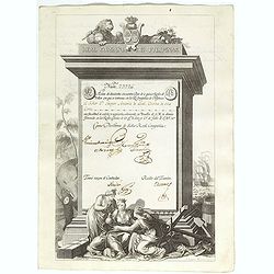
A scarce Real Compañia de Filipinas 250 Pesos deed issued in 1785
A scarce Real Compañia de Filipinas 250 Pesos deed issued in 1785. Share nº 23726, hand signed by several company officials.Engraved by Fernando Selma (1752-1810) after...
Place & Date: Spain, 1785
-250x250.jpg)
Lyste vande prysen der goederen ingekoft by de Kamer. . .
Rare price list of meat, bacon, wheat, rye, butter, cheese, olive oil, Spanish wines, Bordeaux, brandy etc.On front page in letter press Lyste Van de Pryfen der Goederen,...
Place & Date: Amsterdam, 1685

III. Gallia. Franckrych.
Very early wood cut printed map of France, North of river Rhine, Northern Italy. Coast of England from Dover to Cornwall. A ship, sea monsters and coats of arms are filli...
Place & Date: Zurich, Christoffel Froschover, 1548,1552-1566

Malte Vue prise de la Mer. - Malta Vista lomada del mar.
Very decorative view of the Grand Harbour of Malta by Louis Lebreton, published in "Ports de Mer d’Europe" in 1859 by L. Turgis in Paris.This lithography show...
Place & Date: Paris, Turgis, 1859
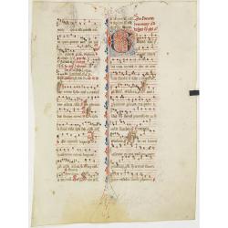
Leaf on vellum from an antiphonary.
A more than 600 years old antiphonary leaf, written in Besançon, in 1370. Musical notation on 4 bars, the staves are in red and the notes in black: numerous pen-flourish...
Place & Date: Besançon, 1370

Karte von Europa im Jahre 1870 nach einem französischen Holzschnitte.
Satirical illustration by Paul Hadol showing disposition of power in Europe at the beginning of 1870. Satirical print depicting a map of Europe in which the countries are...
Place & Date: Hamburg, Fuchs, 1914

Carte routière de l'Indochine. Des kilomètres en sécurité sur Goodrich.
Advertising poster for the brand Goodrich, showing a map of Indochina.Goodrich Corporation is a former American company specializing in civil and military aeronautical eq...
Place & Date: Paris, ca 1934

A ship's hour glass.
Maritime hourglass with blown glass bulbs, orange sand, junction ring covered with cord, the circular ebony frame with six turned baluster columns.The invention of the ho...
Place & Date: The Netherlands, Germany, ca. 1750

Japan (poster signed by Georges Mathieu)
Dedicated "Pour Benijs Boulanger" and signed "Georges Mathieu", in black marker. Decorative poster advertising flights to Japan made by Georges Mathie...
Place & Date: Paris, 1967

Histoire Socialiste.
Text includes “Imp. Centre de Propagande, des Républicains Nationaux, 102, rue Amelot, Paris (XIe), ou l’on peut se procurer cette affiche. Cette affiche ne peut êt...
Place & Date: Paris, 1931

Carte des Isles de Maiorque Minorque et Yvice dediée A.M. le Comte de Maurepas Ministre et secretaire d'Etat. . .
Fine map of the Baleares with much detail, in lower part inset "Plan du Port de Mahon du Fort St. Philippe et ses Fortifications". The map is dedicated to Jean ...
Place & Date: Amsterdam, after 1740
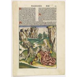
Prima Etas Mundi. IX (with Eve nursing Kain and Abel)
A very fine presentation of Eve nursing Kain and Abel. Adam is working (255x220 cm). VERSO a genealogy of Adam.Page from the richest illustrated Incunabel, the famous: Li...
Place & Date: Nuremberg, 12 July 1493

Wittstocs.
Very decorative and rare panoramic of Wittstock, Bez. Potsdam.The engraver and publisher of prints, Mrs. Anna Beek of the Hague, enlarged the print and mounted it on larg...
Place & Date: The Hague, ca. 1642

Virginiae Partis Australis, et Floridae Partis Orientalis.
Blaeu based this map on the Mercator-Hondius of 1606. A number of geographical improvements, however were incorporated, although two large fictions lakes accompanied by e...
Place & Date: Amsterdam, 1640

View of the harbour of Taloo, in the island of Eimeo.
John Webber View of the Harbour of Taloo on Moorea (Society Islands), from "Views in the South Seas" being a very important and early views depicting scenes enc...
Place & Date: London, Boydell and Co., 1808

The narta, or Sledge for burdens in Kamtschatka.
The narta, or Sledge for burdens in Kamtschatka, taken from "Views in the South Seas" being a very important and early views depicting scenes encountered while ...
Place & Date: London, Boydell and Co., 1808
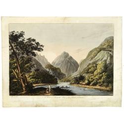
A view in Oheitepeha Bay in the Island of Otaheite. (Tahiti)
A view of Vaitepiha Bay (Tahiti), with a mountainous landscape, with a river in the centre, a small canoe, Tahitian houses to the right, and a Tahitian couple in the left...
Place & Date: London, Boydell and Co., 1808
![Aou, Tōkei. Kokugun Zenzu [Atlas of Provinces and Counties of Japan]. (volume 1 only)](/uploads/cache/63619-250x250.jpg)
Aou, Tōkei. Kokugun Zenzu [Atlas of Provinces and Counties of Japan]. (volume 1 only)
First edition. Very attractive early Japanese Atlas of detailed maps of Japanese regions compiled by six Japanese civilians in the eighth year (1837) of the Tenpō era (...
Place & Date: [Nagoya]: Tōheidō, Tenpō 8 = 1837

CARTE de la Côte Occidentale de COREE, Plan Croquis de la Rivière HAN-KANG ou de SEOUL, depuis son Embouchure jusqu'à Séoul, dressée en 1866 ...
Uncommon chart of the Han-Kang River from its mouth to Seoul, prepared in 1866 by order of C.A. ROZE, Commander-in-Chief of the French " la Station des Mers de Chine...
Place & Date: Paris, 1868

Tschopau.
Very decorative and rare panoramic of Tschopau.The engraver and publisher of prints, Mrs. Anna Beek of the Hague, enlarged the print and mounted it on larger paper: she ...
Place & Date: The Hague, ca. 1700
![Sexta Etas Mundi. Ratisbonna. [Ratisbonne]](/uploads/cache/13549-250x250.jpg)
Sexta Etas Mundi. Ratisbonna. [Ratisbonne]
A very fine presentation of the city of Ratisbon, in Germany, centered on the cathedral (Dim. : 191 mm W : 525 mm).Overleaf a very nice view of Vienna, with two swans on ...
Place & Date: Nuremberg, 12 July 1493

Mexico.
Unusual poster for Mexican tourism, published by Asociacion Mexicana de Turismo, The artist is unknown and the design is surreal and modern at the same time.The popularit...
Place & Date: Mexico, ca. 1935

Réseau aérien mondial.
"Sur les ailes d'Air France, découvrez le monde à votre tour" lithograph poster from AIR France. A great mid-century design by Air France advertising poster b...
Place & Date: Imprimerie Perceval Paris, ca. 1940-1950
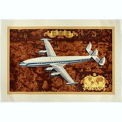
AIR France - Super constellation, Lockhead L - 10 - 49.
Promotional poster attributed to Lucien Boucher showing of a Lockhead L - 10 - 49 on a Mercator projection world map. The map depicts a pictorial map of the entire world ...
Place & Date: Perceval, Paris, 1953

Imperium Russicum, cum regionibus adiacentibus duabus Tabulis ex optima quae A. 1784 tribus foliis comparavit Mappa geographica, aliisque subsidiis delineatum a C. Mannert, Tabula Ima. . .
A detailed map of the European part of the Russian Empire. Scarce map. Copper etching by C. Mannert and edited by Adam Gottlieb Schneider and Johann Christoph Weigel. Man...
Place & Date: Nuremberg, 1794

Germaniae Nova ac Accurata Descriptio.
This "carte à figures"- map covers the Low Countries, Germany, Poland, Switzerland and Austria. Overall a very good copy of this excellently engraved, uncommon...
Place & Date: Amsterdam, 1642

Virginie, Grande Region l'Amerique Septentrionale...
Pierre van der Aa used the old copper plate of Meurs and re-did the engraving, changed the large pictorial cartouche, a new scale of German and French leagues is provided...
Place & Date: Amsterdam, 1729

Vue de Gattweick et de l'embouchure du Rhin, dans la Mer du Nord.
Very decorative view of Katwijk. Signed lower right, Louis Bleuler au chateau de Laufen . Original design by Louis Bleuer. This gouache was the model for his aquatint in ...
Place & Date: 1820

Quarta pars Brabantiae cujus caput Sylvaducis.
A good and dark impression in strong original colors.The third state. The coat of arms of Brabant and 's-Hertogenbosch appears on the map. The municipal arms in the colum...
Place & Date: Amsterdam, 1645
![Generalkarte vom Königreich Preussen u. d. Herz[ogtum] Warschau nach astronomischen Ortsbestim[m]ungen und geodätischen Messungen. . .](/uploads/cache/37060-250x250.jpg)
Generalkarte vom Königreich Preussen u. d. Herz[ogtum] Warschau nach astronomischen Ortsbestim[m]ungen und geodätischen Messungen. . .
Rare seemingly unrecorded map of Poland with its borders after the Congress of Vienna, probably based on a lost first edition of Daniel Friedrich Sotzmann's (1754-1840) m...
Place & Date: Nuremberg, Schneider & Weigel 1815

De Stadt Jerusalem.
Plan of ancient Jerusalem from a Dutch bible after Villalpando. The print is in contemporary colors, which is extremely rare for a plate like this. Lower left the Temple ...
Place & Date: Amsterdam, 1710

Carte des Principales Ports de Mer Bancs de sable &c: qui sont dans la Mer Rouge..
Some cities existed along the western coast of the Arabian peninsula, where they served as entrepots for transcontinental trade between Europe and Asia. Mecca, founded by...
Place & Date: Amsterdam, 1720

Volna.
Very decorative and rare panoramic town-view of Volna. We have more Anna Beek prints available.The engraver and publisher of prints, Mrs. Anna Beek of the Hague, enlarg...
Place & Date: The Hague, ca. 1700

Carta Topografica dell' Isola Del Maritaggio di Monsieur le Boble per la prima volta. Tradotta dal francese in italiano.
Second Italian printing of Eustache Le Noble’s "Carte de l’isle de marriage." The book’s text offers instructions on how to reach this matrimonial island ...
Place & Date: Cosmopoli, 1766
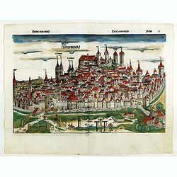
Nuremberga. Folio C.
Double page panoramic view of Nuremberg. Lettered above the view: "NVREMBERGA"; and with the names of the city's two most famous churches, S. Lorenz and S. Seba...
Place & Date: Nuremberg, 12 July 1493
Selling price: $1500
Sold in 2023
![[Lot of 4 charts] Plan de la Baie et du Port de Camraigne / Plan de la Baie de Niatrang et du Golfe de Binkang / Plan de la Cote de Cochinchine. . . / Plan des Ports de Xuandai, Vung-Lam. . .](/uploads/cache/44795A-250x250.jpg)
[Lot of 4 charts] Plan de la Baie et du Port de Camraigne / Plan de la Baie de Niatrang et du Golfe de Binkang / Plan de la Cote de Cochinchine. . . / Plan des Ports de Xuandai, Vung-Lam. . .
[A set of four French sea charts numbered consecutively]. A set of 4 basic coastal sea charts of parts of southern French Indochina (Vietnam).Chart 295 centers on the reg...
Place & Date: Paris ca 1780

Sincapour.
Early view of Singapore after Paris and engraved in aquatint technique by Sigismond Himely (1801-1872). Published as plate 28 in Voyage autour du monde par les mers de l'...
Place & Date: Paris, Finot, 1835

Chosen Danpan - Korean negotiation.
A scene of a Japanese legation under the command of Hanabusa Yoshitada who is forcing the Korean King Kojong (1852-1919) to agree to Japanese demands during the Chemulpo ...
Place & Date: August 8, MEIJI 27th year or 1894
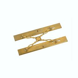
Marine parallel rulers in brass.
Very fine marine parallel rulers in brass. The parallel ruler is the oldest and most traditional way to measure and trace routes and bearings. The principle is simple: t...
Place & Date: Paris, ca. 1880

Stoel des Oorlogs in America Waar in Vertoont Werden Alle Desself Voornaamste Eylande . . .
Large impressive map of the West Indies with the Gulf of Mexico and Florida. The map shows prominently in the center Cuba, Haiti, the Bahamas and Florida, which is here m...
Place & Date: Amsterdam, c. 1720
![[No title] 'Daniel's Dream Map' or 'Wittenberg World Map'.](/uploads/cache/34785-250x250.jpg)
[No title] 'Daniel's Dream Map' or 'Wittenberg World Map'.
Wood block print engraved by the famous engravers Jost Amman and Virgil Solis - with their initials in lower bottom of the map. This somewhat curious map of Europe, Afric...
Place & Date: Cologne, ca. 1564
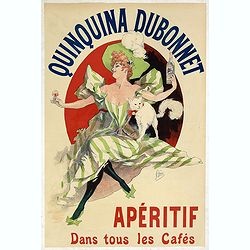
Quinquina Dubonnet, apéritif dans tous les cafés.
Original chromo lithographed medium size poster, "Quinquina Dubonnet, apéritif dans tous les cafés", by CHERET, signed in the plate. Supplement to "Courr...
Place & Date: Paris, Imprimerie Chaix, 1895
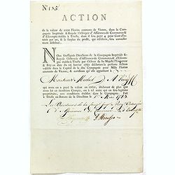
Share of 1000 Florins to Michel de Knyff. N° 135.
Share of 1000 Florins, paid in four tranches at 250 Florins of Vienna, from "Compagnie Imperiale & Royale Octroyee d'Assurance de Commerce & d'escompte."...
Place & Date: Trieste, 1782 - 1783

A rare suite of 12 original etchings by Martin van Maele to the famous work by Edmond Haracourt.
A rare suite of 12 original etchings by Martin van Maele to the famous work by Edmond Haracourt. The series was published anonymously in a small edition. These etchings a...
Place & Date: Nevers, Brussels, 1882,1883
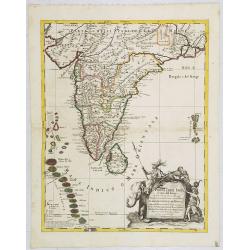
Penisola dell India di là dal Gange et Isole intorno ad essa adiacenti..
Giacomo Rossi's fine late 17th century map of India with Ceylon and Maldives. Issued in Il Mercurio geografico In lower right hand corner a large title cartouche with ded...
Place & Date: Rome, 1683-1688

(Untitled view from Scutari with a view of Constantinople)
Panoramic view from Scutari with a view of Constantinople in the distance, after a design by Johann Schranz. Published by J. Missiriè.
Place & Date: Paris, 1860

Strasborcs In der Vocker Marckt.
Very decorative and rare panoramic town view of Völckermarckt in Kärten.The engraver and publisher of prints, Mrs. Anna Beek of the Hague, enlarged the print and mounte...
Place & Date: The Hague, ca. 1642

Carte des Trois Arabies. Tiree en Partie de l'Arabe de Nubie, en Partie de Divers autres Autheurs. . .
Rare map of the Arabian Peninsula, first published in 1654 and one of the first large maps focused specifically on the Arabian Peninsula. Sanson's map of the Arabian Peni...
Place & Date: Paris, 1654

Manuscript plan of Havana harbour.
Manuscript chart with good nautical detail and soundings of Havana harbour.
Place & Date: Spain c.1820

La mer Mediterranee divisee en ses principales parties ou mers. . .
Very large map centered on the Mediterranean. With a sub title along upper margin "La Mer Mediterranée divisée en Mer de Levant et de Ponant Subdivisées en Leurs ...
Place & Date: Amsterdam, c.1705

Indonesia.
Original vintage travel advertising issued by the Indonesian Council for Tourism featuring a colorful pictorial map marking the islands and oceans with images of local pe...
Place & Date: Jakarta, ca. 1955

Nader prolongatie van het Octroy voor de Westindische Compagnie voor den tyd van nog dertig jaaren. . .
A proclamation by the Dutch States General, dated 1761, extending the charter of the Dutch West India Company for another thirty years. Like the 1730 proclamation, it has...
Place & Date: Amsterdam, 1761
Coupe d'une galère avec ses proportions - Quille d'une Galere sur le chantier.
Fine double-page engraved plate of a cutaway of a standard late 17th-century French galley with a detailed legend of parts (in French). Below is a representation of the k...
Place & Date: Amsterdam, 1695
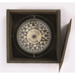
Compass.
A very nicely crafted sloop compass in original box. The compass is gimbaled and is executed in beautiful red copper. Made and signed by F.J. Kloos & Son of Rotterdam...
Place & Date: Rotterdam, 1850-1875
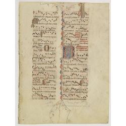
Leaf on vellum from an antiphonary.
A more than 600 years old antiphonary leaf, written in Besançon, in 1370. Musical notation on 4 bars, the staves are in red and the notes in black: numerous pen-flourish...
Place & Date: France, 1370

Pecheli, Xansi, Xantung, Honan, Nanking, In plaga Regni Sinensis. . .
A map of the northern provinces of China after the Jesuit Martino Martini, depicting of Hebei (Pecheli), Shanxi (Xansi), Shandong (Xantung), Henan (Honan), and Jangsu (Na...
Place & Date: Amsterdam, ca 1660
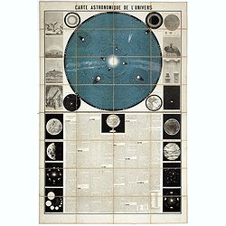
Carte Astronomique de L'Univers.
A large and decorative, informative chart illustrating and describing the Solar System, backed by the stars, printed in blue and black, surrounded by further 17 vignette ...
Place & Date: Paris, 1875

Potentissimo Borussorum Regi Friderico Wilhelmo Maiestate, Fortitudine Clementia Augustissimo Hancce Lithuaniam Borussicam : in qua luca coloniis Salisburg., ad incolendum Regio nutu...
Potentissimo Borussorum Regi Friderico Wilhelmo Maiestate, Fortitudine Clementia Augustissimo Hancce Lithuaniam Borussicam : in qua luca coloniis Salisburg., ad incolendu...
Place & Date: Nuremberg, 1735

ANNA IWANOVNA - Anna Ioannovna imperatricea i camoderschiza wserossinskaja (rossice). Anna Joannowna imperatrix totius Russiae
Extremely rare half portrait print of Anna Ivanovna (7 February [O.S. 28 January] 1693, Moscow – 28 October [O.S. 17 October] 1740) reigned as Duchess of Courland from ...
Place & Date: St. Petersburg, 1743

ELISABETH I. - Elisabet imperatriza wseros sinskaja petra welikago dscherj (rossice). Elisabetha imperatrix. Omnium Russiarum Petri. Magni. Filia.
Extremely rare half portrait print of Elizaveta Petrovna (29 December [O.S. 18 December] 1709 – 5 January 1762 [O.S. 25 December 1761] ), also known as Yelisavet and El...
Place & Date: St. Petersburg, 1743

FJODOR JOANNOWITSCH - Feodor Ioannowitsch zar i camoderschez wserossinskij (rossice). Feodor Ioannowicz tzaar et autocrator totius Russiae Joann Alexiewicz tzaar et autocrator totius Russiae.
Extremely rare half portrait print of Czar Fyodor I Ivanovich (31 May 1557 – 16/17 January 1598) was the last Rurikid Tsar of Russia (1584 - 1598), son of Ivan the Terr...
Place & Date: St. Petersburg 1743

ALEXEI I. - Alexei Michailowitsch zar i camoderschez wserossinskij (rossice). Alexei Michailowicz tzaar et autocrator totius Russiae.
Extremely rare half portrait print of Czar Alexei Michailowicz..Aleksey Mikhailovich Romanov ( 9 March 1629 (O.S.) – 29 January 1676 was the Tsar of Russia during some ...
Place & Date: St. Petersburg, 1743

IWAN ALEXEJEWITSCH - Ioann Alexejewitsch zar i camoderschez wserossinskij (rossice).Joann Alexiewicz tzaar et autocrator totius Russiae.
Extremely rare print of Czar Ivan Alexejewitsch, who was the brother of Peter the Great.Johann Stenglin was a well known engraver, born at Augsburg in 1715, he studied un...
Place & Date: St. Petersburg 1743

Nuevo plano de la ciudad de Buenos Aires y parte del partido de avellaneda . . .
A rare detailed city plan of Buenos Aires prepared in 1912 by Ernesto Escalante. The plan depicts the city from the Partido de Avellaneda and the Villa Riachuelo to the R...
Place & Date: Buenos Aires, 1912

Hedendaegsche Historie of tegenwoordige staet van alle volkeren 1 deel. (Volume 1 - China, Japan, Phillippines, Moluccas)
This provides an interesting illustrated description of China, Japan, the Phillippines, Moluccas. Including a map of China, Korea, and Japan, with the Sea between Korea a...
Place & Date: Amsterdam, 1734
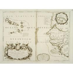
Bocche del Fiume Negro et Isole di Capo Verde.
Double-page engraved map of the Cape Verde Islands and part of the coast of Senegal, with large decorative cartouche. One with inset of the island Goree. During three cen...
Place & Date: Venice, 1690
![[Spain and Portugal]](/uploads/cache/47718-250x250.jpg)
[Spain and Portugal]
A rare map of Spain and Portugal engraved by Jan and Lucas van Deutecom and published by Gerard de Jode, Antwerp 1593. Latin text on verso.The map appeared in the second ...
Place & Date: Antwerp, 1593

Pianta Della Citta di Roma con la Indicazione di tutte le Antichita e Nuovi Abbelliment.
Beautiful engraved town-plan of Rome with side borders depicting the 16 most important monuments and with a legend locating the major places and buildings.The views are o...
Place & Date: Venanzio Monaldini, Rome, 1829
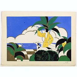
(Art déco gouache)
Outstanding "art deco" gouache (unsigned) from the workshop of "Robert Pichon. Ateliers de Dessin et Lithographie – 10, rue Rochechouart – Paris. The g...
Place & Date: Paris, ca. 1930

Carte de l'Ile de Java.
An inset plan of Batavia and clearly indicated rice fields, mountains, forests, towns in profile and even elephants suggest the wealth of detail found on this map. Modele...
Place & Date: Amsterdam, 1720
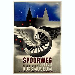
Spoorweg Museum Thans in Het Rijksmuseum.
Interesting Art Deco style poster for the Railway Museum, now in the Rijksmuseum. Carolus Adrianus Maria Thole (20 April 1914 – 26 March 2000) was a Dutch-Italian paint...
Place & Date: Amsterdam, 1942

Het Beloofde Landt Canaan door wandelt . . .
A beautifully engraved map of the ancient land of Canaan which roughly corresponds to present-day Israel. Cherubs hold up a draped cloth of key symbols, also a scale pane...
Place & Date: Amsterdam, 1682

La Florida/ Peruviae Auriferae regionis Typus/ Guastecan.
The Chaves map of Florida is a prime example of an explorer's map since it records the recent discoveries of Cabeza de Vaca, De Soto, and Moscoso. The map revealed little...
Place & Date: Antwerp, 1592
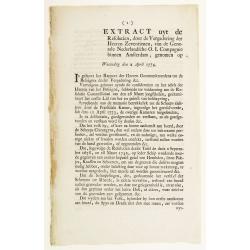
Extract uyt de Resolutien, door de Vergadering der Heeren Zeventienen, van de Generale Nederlandsche O. I. Compagnie binnen Amsterdam, genomen op Woensdag den 2 April 1774.
Contains a list of resolutions dated from 2nd April 1774 and concerning health care. Boarding crew had to be examined by the ship's surgeon. People with illnesses were to...
Place & Date: Amsterdam, 1751

Cunard to Canada.
Poster by Charles Eddowes Turner for Cunard lines. The poster shows The NEW SYLVANIA, one of the four new 22,000 - ton Cunarders which are the largest ever built for serv...
Place & Date: England, ca. 1930

Carte des découvertes fautes en 1787 dans les Mers de Chine et de Tartarie par les Frégates Françaises la Boussole et l'Astrolabe. . . ée. Feille.
La Pérouse's important large-scale of Northern Japan, Hokkaido, the Kuriles, the tip of Kamschatka, and the northern part of Korea.Showing the track of Perouse from 27 ...
Place & Date: Paris, 1797

Map of the Great Salt Lake And Adjacent Country in the Territory Of Utah. Surveyed in 1849 and 1850, under the orders of Col. J.J. Abert ...
Map of the Great Salt Lake And Adjacent Country in the Territory Of Utah. Surveyed in 1849 and 1850, under the orders of Col. J.J. Abert .. by Capt. Howard Stansbury .. a...
Place & Date: Ackerman, New York, 1852