Browse Listings in Europe > Netherlands

Zeelandiae Comitatus.
Rare map of Zeeland, with inset view of the town of Middelburg topped with costumed figures. This is the second edition published by Claes Jansz. Visscher. The first edit...
Place & Date: Amsterdam, 1617-1631

Inferior Germania.
A rare miniature map of present-day The Netherlands and Belgium. Strap-work title cartouche in the lower right corner with scale. Expertly engraved by Petrus Kaerius, the...
Place & Date: Amsterdam, 1606

Deliciae Batavicae.
It is a charming book illustrated with portraits of Willem of Orange and Prince Maurits and eight engraved armorial plates. Followed by 30 engraved views or scenes of ...
Place & Date: Amsterdam, Johannes Janssonius, 1618

Hollandia Comitatus.
Orientated west to the top of the sheet, this presents the County of Holland in the classical orientation for seventeenth-century maps, with Amsterdam at the center. The ...
Place & Date: Amsterdam, 1660

Belgii sive Germaniae Inferioris accuratissima tabula.
Very rare and very decorative map with in the right and left borders costumed figures and town plans alternately. In top and bottom border town plans and views.Separate p...
Place & Date: Amsterdam, 1631

Tabula comitatus Hollandiae. . .
Fine map of the provinces of North and South Holland. In upper left hand corner an inset with the islands of Texel and Vlieland.
Place & Date: Augsburg 1760

De Zype. / Purmer / Wormer/ Beemster / Waterland.
Five maps on one sheet. Showing the polders of De Zype, De Purmer, De Wormer, De Beemster and a map of Waterland, including de Bylmermeer and Monnekedam. Showing the Noor...
Place & Date: Amsterdam, 1652-1658

Episcop. Ultraiectinus.
A very detailed map based on Utrecht. Scale cartouche held by a surveyor. Based on the map by B.F.van Berckenrode (1620-21) and engraved by the master engraver Evert Sijm...
Place & Date: Amsterdam, 1630-1632

Vue du village de Maarsen en Hollande.
Showing the river Vecht at the town of Maarsen. Published by Jacques Chereau, who was a well-known publisher of optical prints, established in rue St. Jacques in Paris. I...
Place & Date: Paris, ca. 1750

Vue perspective edu fauxbourg et du port de Scheveningue a une lieue de la Haye, en Hollande.
Optical print showing the village and harbor of Scheveningen with the church at the right, in the background the North Sea. In the background the summer residence Nieuw S...
Place & Date: Paris, ca. 1750

A view of Amsterdam taken from the Old Rampart.
So-called optical print of Amsterdam, published by Jean Mondhare after a print by Laurie and Wtitle. With captions in English and French above and belowIn the eighteenth ...
Place & Date: Paris, ca. 1760

't Hooge Heemraedschap van Delfland met alle de Steden, Dorpen, Ambachten, Litmaten, Polders, (etc.).
The so-called Kruquius map is a wall-map of the Delfland water board district. The map consists of 25 engraved map sheets. Several maps flanked by fine large armorial car...
Place & Date: Delft, 1712-1750

Amsterdam Capitale de la Hollande.
A panoramic of Amsterdam seen from 't IJ. Set within a decorative border, printed from a separate plate. Rare.
Place & Date: Leiden, 1720

't dorp Aalst.
Rare print of the old church of Aalst (near Eindhoven), from Vaderlandsche gezichten of afbeeldingen.. by J.Bulthuis, printed by H.Gartman in Amsterdam.
Place & Date: Amsterdam, 1786 / 1792

Mastric ou Maëstricht, Ville du Brabant-Hollandois. . .
A very decorative and extremely rareof Maastricht, including a numbered key (1-23) in lower part. Engraved by Pierre-Alexandre Aveline. With "Fait par Aveline avec p...
Place & Date: Paris, ca.1692

Fossa Sanctae Mariae.
Detailed map of part of the country between rivers Rhine and Meuse showing a canal to be dug between 1626 and 1628 between Rheinberg in Germany and Venlo. A deficiency of...
Place & Date: Amsterdam, 1645

Kaart van Zeeland.
Fine map of the province of Zeeland, with the fortified cities are highlighted in red. Isaac Tirion was born in Utrecht ca. 1705. He came to Amsterdam ca. 1725. Tirion pu...
Place & Date: Amsterdam, 1747

Tabula Episcopatuum Leodiensis et Coloniensis. . .
Rare issue of Cornelis Danckert's attractive map of Limburg, shows the area of Cologne, Mainz, Trier, Jülich, Mons, Antwerp and Liege in Belgium.Decorative title cartouc...
Place & Date: Amsterdam, 1700

Vermakelykheden van Brabant, en deszelfs onderhoorige Landen... (2 volumes)
Topographical and iconographical work on Brabant illustrated with 1 engr. title-vignette and 190 engraved views, plans & armorial plates by J. Harrewijn, G. Bouttats ...
Place & Date: Amsterdam, P.J. Entrop, 1768

Frisia occidentalis.
A rare separately published carte-a-figures of Friesland by Geelkercken in its first state. The title and the coats of arms of the eleven Frisian towns appear in the cent...
Place & Date: [Leeuwarden], Dierick Albertsen, 1618

Amstelodamum, Celebre Emporium Forma Plana.
Second state of this rare and decorative plan of Amsterdam with Visscher's imprint. With a panoramic view seen from the IJ and further insets of Council House, The Exchan...
Place & Date: Amsterdam, c. 1636

Nieuw Nederlandtsch Caertboeck. Waer in volkomentlijcker als oyt te voren vertoont werden de XVII. Nederlanden.
Rare first edition of this atlas of the provinces of the Netherlands, Belgium and Luxemburg. Engraved title page, with : "Gedruckt t' Amsterdam by Abraham Goos Plaet...
Place & Date: Amsterdam, 1616

Descrittione di M. Lodovico Guicciardini patritio Fiorentino, di tutti i Paesi Bassi,...
Second Italian edition (variant B) and first Plantin edition (1st Silvius 1567) and the most sought-after edition of the famous description of the Low Countries, updated ...
Place & Date: Antwerp, Plantin, 1581

The hanging of the head of police Jean Grauwels in Brussels, 11 february 1569.
Print relating to Brussels during the first decades of the eighty year war between Spain and the Low Countries: (plate 18). This plate shows the hanging of the head of po...
Place & Date: Cologne, ca. 1590

Tabula Bergarum ad Zomam Stenbergae et novorum ibi operum.
The map gives an outline of the Scheldt from Bergen op Zoom to Antwerp, with all the ramparts built between 1622 and 1627.
Place & Date: Amsterdam, 1647

Amsterdam Ville du comté de Hollande. . .
A very decorative and very rare town-view of Amsterdam, including a numbered key ( A- T) in the lower part. Engraved by Pierre-Alexandre Aveline. With the signature "...
Place & Date: Paris, ca.1692

Sexta Etas Mundi. Folium. CCXVII (dancers of Maastricht).
Latin text page with woodcuts of male Siamese twins, a man headed lion. The large illustration is the only illustration related to the Netherlands : it shows a bridge col...
Place & Date: Nuremberg, 12 July 1493

Novus XVII Inferioris Germaniae Provinciarum Typus.
Willem Blaeu published this map in 1608 as a wall map with figured borders. When later, in 1630 he needed a general map of the Netherlands for his first atlas, the Append...
Place & Date: Amsterdam, 1634

Ultrajectum.
An original early 17th century copper engraved miniature antique map of the Dutch province of Utrecht by Petrus Bertius, that was published in Amsterdam at the beginning ...
Place & Date: Amsterdam, 1606

Nova XVII Provinciarum Inferioris Germaniae descriptio .
Extremely rare map of the Benelux by Frederick de Widt. Originally engraved and published by P.Kaerius in 1607. In 1662 the plate came in the possession of Frederick de W...
Place & Date: Amsterdam, 1662

Plan de la ville de Maestricht avec ses attaques commandées par M. le maréchal de Saxe, depuis le 15 avril jusqu'au 3 may 1748 . . .
A plan of Maastricht rising after the capture of the city by the French troops led by the Marshal of Saxony. The city was besieged between 15 April and 3 May 1748, during...
Place & Date: Paris, 1781

Nieuwe en zeer accuraate Zee-Caart van de Hollandse Wal strekkende van de Maas tot Texel opgenomen door Jan Rokusz Douw, , ,
A very fine and rare chart of the coast of Holland, Prepared by Jan Rokusz, Douw and Agge Roskam Kool.Embellished with a very decorative cartouche with a dedicational tex...
Place & Date: Amsterdam, 1750

Fossa Sanctae Mariae.
Detailed map of part of the country between rivers Rhine and Meuse showing a canal to be dug between 1626 and 1628 between Rheinberg in Germany and Venlo. A deficiency of...
Place & Date: Amsterdam, 1645

Amsterdam Ville du Comté de Hollande et la plus considerable des Provinces Unies. . .
A very decorative and extremely rare town-view of Amsterdam, including a numbered (1-18) key in lower part. Extensive shipping on the IJ. To the left the headquarters of ...
Place & Date: Paris, ca.1750
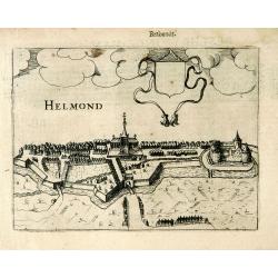
Helmond.
A panoramic view of the Helmond, seen from the Kromme Steenweg .
Place & Date: Arnhem, 1613

Limburgensis Ducatus Tabula Nova.
Map of Limburg, prepared by the Antwerp expert in law and mathematics Aegidius Martini. After 1600 Jan Baptist Vrients acquired the stock and the plates of Ortelius' Thea...
Place & Date: Antwerp, 1606-1612

Middelbourg Ville la plus considerable de l'Isle de Walcheren et du Comté de Zelande l'une des huit provinces Unis des pais-bas . .
A very decorative and extremely rare of Middelburg, including a numbered (1-19) key in lower part. Published by Jacques Chéreau, (1688 - 1776). Engraved by Aveline and ...
Place & Date: Paris, ca.1750

Nouvelle Carte des dix-sept Provinces des Pays-Bas.
Map of the 17 provinces of the Netherlands. In an inset upper left corner 17 coats of arms of each province and vignettes. The Channel is filled with Naval battles fought...
Place & Date: Amsterdam, ca. 1720

Die Zyp / La Zype.
A miniature map showing the polder of De Zype. Title cartouche in the upper side.First published in 1598 in his Caert-Thresoor, the plates were executed by the most famou...
Place & Date: Amsterdam / Frankfurt, 1609

Vue de Gattweick et de l'embouchure du Rhin, dans la Mer du Nord.
Very decorative view of Katwijk. Signed lower right, Louis Bleuler au chateau de Laufen . Original design by Louis Bleuer. This gouache was the model for his aquatint in ...
Place & Date: 1820