Browse Listings in Map Types > Asian Made Maps & Items

Nansenbushu bankoku shoka no zu.
This wall-map is a great example of Japanese world maps representing Buddhist cosmology with real-world cartography. It is the earliest one and - therefore - the prototyp...
Date: Kyoto, (Hoei 7 = Year of the Tiger) 1710

Paldobundo Province.
Woodblock printed map of Jeolla Province which was one of the historical Eight Provinces of Korea during the Kingdom of The map is drawn in "Paldo Bundo," styl...
Date: 1710-1718
![Ch'onha chido.[Atlas of all under Heaven]](/uploads/cache/44639composition-world-250x250.jpg)
Ch'onha chido.[Atlas of all under Heaven]
A late 18th-century Ch'onha chido atlas with 13 woodblock maps showing the World, China, Korea, Japan, Okinawa, and the 8 provinces. The seas are in black.Slight wear, co...
Date: Korea, ca. 1760
![Ch'onha chido. [Atlas of all under Heaven]](/uploads/cache/44640-250x250.jpg)
Ch'onha chido. [Atlas of all under Heaven]
A late 18th-century Ch'onha chido atlas with 10 woodblock maps showing the World, China, and the 8 province maps of Korea (Hamgyeong, Gangwon, Jeolla, Gyeongsang, Pyeonga...
Date: Korea, ca. 1780
![CH'ONHA CHIDO [Atlas of all under Heaven]](/uploads/cache/33625-250x250.jpg)
CH'ONHA CHIDO [Atlas of all under Heaven]
The Ch’onha chido [Atlas of all under Heaven] is a late 18th century copy of the traditional Korean atlas produced in the early Choson dynasty (1392-1910). One of the map...
Date: Korea, ca. 1790
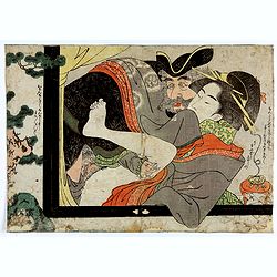
Dutchman and a Maruyama prostitute.
An explicit scene of a Dutchman and a Maruyama prostitute featuring a gray-bearded westerner coupling with a courtesan. The woman protests that she doesn't understand wha...
Date: Late Edo, 1790

SETTSU MEISHO ZUE. Illustrations of famous places in Settsu.
Settsu Meisho Zue was printed in two series of 8 and 4 volumes. The principal illustrator was Takehara Shunchosai, but many illustrations in the 4 volumes supplement are ...
Date: Osaka, Yanagiwara Kibei, Kansei 8-10 or 1796-1798

Shinkan Nagasaki no Dzu.
The oldest of these so-called Nagasaki pictures (Nagasaki-zu) were two panoramic prints by the artist Chikujuken that served as guides to the city of Nagasaki for visitor...
Date: Nagasaki, 1801
![Morokoshi Meisho Zue [Illustrated Description of Famous Sites of China].](/uploads/cache/34118-250x250.jpg)
Morokoshi Meisho Zue [Illustrated Description of Famous Sites of China].
Published in Osaka, Kawachiya Genhichiro, et al. [8 book sellers], slightly later issue but apparently in Edo period, using all the same woodblocks of original first edit...
Date: Osaka, Edo, slightly later than Bunka 3, year of the tiger - 1806
![Aou, Tōkei. Kokugun Zenzu [Atlas of Provinces and Counties of Japan]. (volume 1 only)](/uploads/cache/63619-250x250.jpg)
Aou, Tōkei. Kokugun Zenzu [Atlas of Provinces and Counties of Japan]. (volume 1 only)
First edition. Very attractive early Japanese Atlas of detailed maps of Japanese regions compiled by six Japanese civilians in the eighth year (1837) of the Tenpō era (1...
Date: [Nagoya]: Tōheidō, Tenpō 8 = 1837

Chosen Danpan - Korean negotiation.
A scene of a Japanese legation under the command of Hanabusa Yoshitada who is forcing the Korean King Kojong (1852-1919) to agree to Japanese demands during the Chemulpo ...
Date: August 8, MEIJI 27th year or 1894

KOUSHI NYUJO no Zu - HANABUSA Legation enters in Palace, Seoul.
A scene of Japanese legation HANABUSA who are entering the Royal Palace, Seoul.
Date: August 8, MEIJI 27th year or 1894
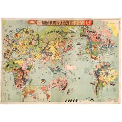
Japanese Stereotype Map of the World from 1932 Share Hitome de wakaru Manga sekai genjō chizu. At a glance: Cartoon Map of the Current World Situation. 目でわかる 漫画世界現状地圖
An extraordinary satirical map of the world was seen through Japanese eyes in the early 1930s as Japanese imperial ambitions strengthened. The map was published as an edi...
Date: Tokyo, Showa 7, or 1932
