Browse Listings in Map Types
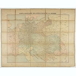
Carte populaire des opérations de la guerre. 2ème édition.
Folding map. War Operations Map showing a part of Europe, published by Epinal.
Date: Paris, ca. 1919
![[6 Post cards of young woman seated on a globe ]](/uploads/cache/41502-250x250.jpg)
[6 Post cards of young woman seated on a globe ]
Complete set of 6 pictorial post cards showing young women seated on a globe. Signed "Morin". Unsent.More aboutcartographical curiosities [+]
Date: Italy, ca. 1920
![Hoo Daihiko Kinen Hiko Sugoroku [ [訪欧大飛行記念飛行双六 ]](/uploads/cache/46569-250x250.jpg)
Hoo Daihiko Kinen Hiko Sugoroku [ [訪欧大飛行記念飛行双六 ]
FIRST EDITION. A rare paper board game celebrating a flight from Tokyo to Rome Europe. Published in by Osaka Asahi Shinbun.This color offset-printed sugoroku (a paper “bo...
Date: Osaka, Taisho 14 or 1925
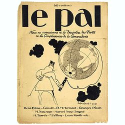
Le Pal - Nous ne connaissons ni la discipline des partis ni les complaisances de la camaraderie.
Original cover design in pen and ink by Henri Desbarbieux for the satirical bi-monthly journal Le Pal.Not much information is found about Henri Desbarbieux. In this BNF l...
Date: Paris, 1925

The Wonderground Map of London.
A large and pictorially striking 'Wonderland' advertising poster on behalf of the London Underground, published in the late 1920s. The poster was very popular, and ran fo...
Date: London, 1927

United States At-A-Glance.
A clever device for demonstrating the statistics of each state, the Area, Population, Highest Elevation, Principal River, Capital, railroad Mileage, Date Entered Union, P...
Date: New York / London: International At-A-Glance Chart Co. 1931
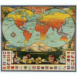
McCormick's Map of the World.
Colorful promotional map of the 20th century spice trade.What better way to showcase the global composition of a multi-national company than with a world map? This lovely...
Date: United-States, 1931
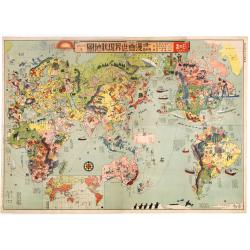
Japanese Stereotype Map of the World from 1932 Share Hitome de wakaru Manga sekai genjō chizu. At a glance: Cartoon Map of the Current World Situation. 目でわかる 漫画世界現状地圖
An extraordinary satirical map of the world was seen through Japanese eyes in the early 1930s as Japanese imperial ambitions strengthened. The map was published as an edi...
Date: Tokyo, Showa 7, or 1932

Philippines Islands.
Pictorial map of Philippines Islands, from the famous illustrator, Ruth Taylor White and published in "Our USA: A Gay Geography".Ruth Taylor White was among the...
Date: Boston, Little, Brown and Company, 1935
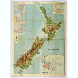
Bartholomew's Touring Map of New Zealand.
A full color map. 'Reduced Survey Map of New Zealand, colored to Show Height of Land'. With insets of Auckland Harbour, Wellington and Port, Christchurch and Port Lyttelt...
Date: Edinburgh, 1935

A Hysterical Map of the Yellowstone Park. . .
A funny 1936 pictorial map of Yellowstone Park, that was 'hatched and scratched' by the American printer and humourist Jolly Elmer Lindgren. This wonderful map covers the...
Date: Spokane, 1936

A Map and History of Peiping; formerly known as Peking; capital of provinces, princedoms and kingdoms since 1121 B.C. . .
The uncommon second edition of this very decorative and informative pictorial map of Beijing and surrounding areas whimsically illustrates the Forbidden City, essential e...
Date: The Peiyang Press, Ltd. Tientsin-Peiping, 1936
![[Magazine including pictorial world map, Carriers of the New Black Plague by William Cotton.]](/uploads/cache/43680-250x250.jpg)
[Magazine including pictorial world map, Carriers of the New Black Plague by William Cotton.]
Front cover with color illustration of a Moroccan male sheik and yellow lettering.Oversized magazine, features analysis of English justice, map of Herr Hitler's heaven (f...
Date: Chicago, April 7th, Vol.1 No.1 1938

Carriers of the New Black Plague.
A powerful satirical commentary on totalitarian control of speech from the first issue of Ken Magazine. "Caught here in all their peculiar beauty by the soul searchi...
Date: Chicago, 1938
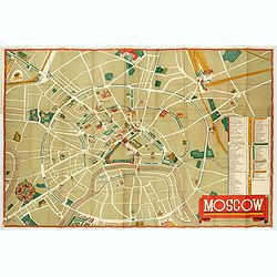
Moscow.
Fantastic pictorial map of Moscow designed to draw tourists to the new Soviet Union.The cultural vitality of Moscow in the early years of the Soviet Union is the focal po...
Date: Moscow, c. 1938

L'Europe en Sept 1939. Ille terrarum mihi angulus ridet.
A rare oversized serio-comic map of Europe at the start of the Second World War depicting stereotypes of 31 countries, as listed in the key lower right, including Brit...
Date: Bruges, Leon Burghgraeve, 1939

The Greyhound Map of This Amazing America. . .
A large colored lithograph map of the USA, published by the Greyhound Corporation during the Second World War. The map demonstrates where all the Greyhound bus routes int...
Date: United States, 1941
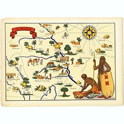
Niger.
Very decorative, informative map of Nigeria. The map is filled with buildings, animals, figures and two locals. With a large compass rose in upper right corner.In lower l...
Date: France, 1943

Carte de la Charte de L'Antique . . .
The rare French version of this decorative pictorial world map by MacDonald Gill. "This magnificent map drawn up while the Second World War still raged is already en...
Date: London, Alf Cooke Ltd, 1943

Carte géologique détaillée. Beyrouth.
Geological or soil map showing part of Lebanon with Beyrouth, including in top a colored legend with signs of the different geological ages. Provenance : Fondation P. Fal...
Date: Liban, Service geographique des F.F.L., 1945

Carte géologique détaillée. Jezzîne.
Geological or soil map showing part of Lebanon with Jezzîne, including a legend with signs of the different geological ages and giving many information of greatest intere...
Date: Liban, Service geographique des F.F.L., 1945

Carte géologique détaillée. Râchaïya Nord.
Geological or soil map showing part of Lebanon with Râchaïya , including a legend with signs of the different geological ages and giving many informations of greatest int...
Date: Liban, Service geographique des F.F.L., 1945

Carte géologique détaillée. Zahle.
Geological map showing part of Lebanon with Zahle. , including a legend with signs of the different geological ages. Provenance : Fondation P. Fallot
Date: Liban, Service geographique des F.F.L., 1945

Carte geologique detaillee. Jbail.
Geological or soil map showing part of Lebanon with Jbail antique Byblos Ancien Port phenicien / scale 1 : 50 000., including a legend with signs of the different geologi...
Date: Liban, Service geographique des F.F.L., 1945

ADSEC in Action from Thames to Rhine.
A pictorial map showing the allied movement from London on 14 March 1944 thru the conquest of Germany. Showing the track from London along Bristol, crossing the British C...
Date: London, 1945
![Mapa geral do Brasil / organizado pelos J. Carneiro da Silva e Pedro Voss. [Together with] Micro geografia do Brasil. [Together with] Pequeno Mapa do Brasil.](/uploads/cache/45466-250x250.jpg)
Mapa geral do Brasil / organizado pelos J. Carneiro da Silva e Pedro Voss. [Together with] Micro geografia do Brasil. [Together with] Pequeno Mapa do Brasil.
Large folding national map published by "Comp. Melhoramentos de São Paulo Industrias de Papel". Nova edicao revista 1946. Figures for all states. "Futuro D...
Date: São Paulo, 1946

A Hysterical Map Of Death Valley National Monument -- And It's Looking Mighty Low
First edition Humorous map of Death Valley. "Drawn In Broken English by Jolly Lindgren," this comic pictorial map is full of puns and comic vignettes related to...
Date: Spokane, Wash., Lindgren Brothers, 1948

Coast to Coast.
A game board that features a map of the U.S. with a built-in spinner. Players travel a circular track around the map visiting landmarks as they go. A fun way to learn geo...
Date: New York, ca. 1950
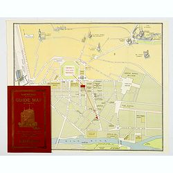
Souvenir Guide Map of Cairo.
A lovely small colored plan of central Cairo, published by Groppi in Cairo. Plan is housed within the original red and gold printed paper covers, with advertisements for ...
Date: Cairo, 1920-1950
![[Planisphère] - Crédit Lyonnais - Fondé en 1863. Afrique du Nord à Union Française.](/uploads/cache/44865-250x250.jpg)
[Planisphère] - Crédit Lyonnais - Fondé en 1863. Afrique du Nord à Union Française.
Original pictorial lithographed advertising poster showing the western part of Africa. Published by the French bank Crédit Lyonnais.Design by Lucien_Boucher who is a famo...
Date: Paris, 1950

A map of the British Army with battle honours and militray achievements and Regimental Badges . . .
Shows English County Regiments, Battle Honours and Military Achievements. Bordered by Regimental Badges.A fascinating piece of British history.Read more about Pictorial M...
Date: London, 1952
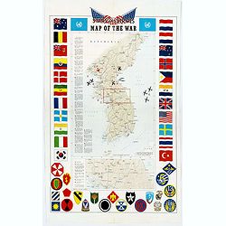
Pacific Stars and Strips Map of the War.
A detailed map of the Korean War. Several silhouetted flying military aircraft are shown in formation. The map shows the Korean Peninsula from its northern border with Ru...
Date: America, 1953
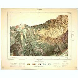
Servoz - Cluses N°8 Sud.
Magnificent 1:10,000 scale color printed map of Servoz (Cluses N°8 Sud) based on stereotopographic ground and aerial surveys carried out in the field in 1950 and rendere...
Date: Paris, 1953

(World map). Americus Vespucio novo te Duce Ducta Freto Ambivi Meritoqs Vocor.
Manuscript world map showing the American and African continent and the southern parts of Asia. In the Indian Ocean a large depiction of Amerigo Vespucci 1454 – 1512) on ...
Date: Italy, ca. 1954
![[No title] Gouache of a class scene with globe, revolting students and a teacher.](/uploads/cache/44404-250x250.jpg)
[No title] Gouache of a class scene with globe, revolting students and a teacher.
Gouache of a class scene with a globe centered on Europe and Africa with revolting students and a teacher. Original design for a pulp publication.
Date: ca. 1950-1960
![[Pictorial map of Georgia (Caucasus)].](/uploads/cache/47135-250x250.jpg)
[Pictorial map of Georgia (Caucasus)].
A scarce pictorial map of a region in Georgia in the Caucasus. Map is entirely in Russian, complete with legend at base of map, with small thumbnail pictures and symbols ...
Date: Moscow, 1963
![[Afghanistan].](/uploads/cache/44611-250x250.jpg)
[Afghanistan].
A scarce Russian relief map (in Russian) of Afghanistan published in Moscow during the Soviet occupation of the country during the early 1980s. Complete with a separate b...
Date: Moscow, 1982
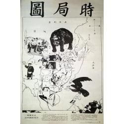
The Situation in the Far East. (時局圖)
An unusual rendering of Tse's "Situation in the Far East". Tse Tsan-tai (1872-1939), a Chinese patriot, drew the original political cartoon in Hong Kong in 1899...
Date: China, n.d. but ca. 1980/1990
