Browse Listings

Carte des Isles du Japon Sequels est remarque la Route..
This uncommon map of Japan, a reduced version of his larger map, contains comments about the nature of the country. For instance, Ocsaqui (Okazaki, near Nagoya) is said t...
Place & Date: Paris / Amsterdam, 1679
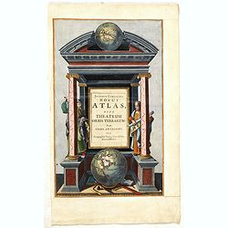
Joannis Janssonii Novus Atlas, sive Theatrum Orbis Terrarum: in quo Orbis Antiquus. . .
A glorious mid-seventeenth century engraved frontispieces to atlas by Janssonius. Finely decorated with a pair of terrestrial (bottom) and celestial (top) globes and the ...
Place & Date: Amsterdam, 1650

Provincia ecclesiastica di Malines nel Belgio (Tav LXII)
This large-format map of Belgium with its different dioceses. The map is finely engraved and beautifully colored and was prepared by Girolamo Petri, a lawyer who served a...
Place & Date: Rome, 1858
![[Map of Corfu. View of the city of Corfu on the foreground. ]](/uploads/cache/45221-250x250.jpg)
[Map of Corfu. View of the city of Corfu on the foreground. ]
Very rare map of Corfu with a view of the city of Corfu on the foreground. Published in the first edition of "Viaggio da Venetia, a Costantinopoli. Per Mare, e per T...
Place & Date: Venice, Giacomo Franco, 1598
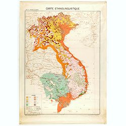
Carte de l'Indochine au 1 : 2.000.000. Carte ethnolinguistique.
Map showing Vietnam, Cambodia, and Laos, prepared under the direction of "l'Ecole Française d'Extrême-Orient". Relief shown by spot heights. With a colored ke...
Place & Date: Hanoï, 1949

The Empire of China and Island of Japan. . .
The map is of interest for the use of East Sea, the sea between Korea and Japan, here called "Sea of Corea". Some interesting notations are made. From his atlas...
Place & Date: London, 1736
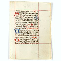
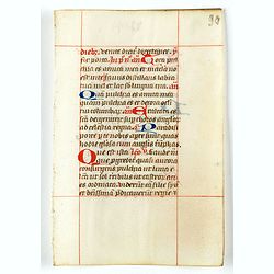
A leaf from a breviary.
Two large 2-line initials in red and or blue for the start of the new chapter.Nice clean leaves, with ample margins, from a breviary, end of the 15th. century.
Place & Date: Northern Netherlands ?, ca. 1480
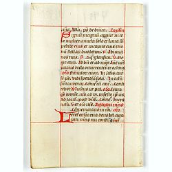
A leaf from a breviary.
Two large 2-line initials in red and or blue for the start of the new chapter.Nice clean leaves, with ample margins, from a breviary, end of the 15th. century.
Place & Date: Northern Netherlands ?, ca. 1480
A leaf from a breviary.
Two large 2-line initials in red and or blue for the start of the new chapter.Nice clean leaves, with ample margins, from a breviary, end of the 15th. century.
Place & Date: Northern Netherlands ?, ca. 1480
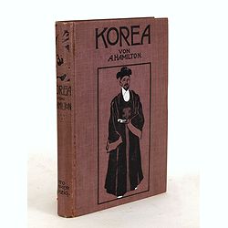
Korea. Das Land des Morgenrots. Nach seinen Reisen geschildert von Angus Hamilton. Autorisierte Übersetzung aus dem Englischen.
With 114 illustrations after photographes and one map.
Place & Date: Leipzig: Spamer, 1904
![Ch'onha chido.[Atlas of all under Heaven]](/uploads/cache/44639composition-world-250x250.jpg)
Ch'onha chido.[Atlas of all under Heaven]
A late 18th century Ch'onha chido atlas with 13 woodblock maps showing the World, China, Korea, Japan, Okinawa, and the 8 provinces. The seas are in black.
Place & Date: Korea, ca. 1760
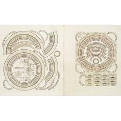
Two sheets for constructing an armillary sphere.
Two sheets for constructing an armillary sphere. Cassini was a geographer and cartographer, but also perspective and architecture carver - one of Giovanni Battista Pirane...
Place & Date: Rome, 1795

Hydrograhica descriptio
This very rare chart is important as the first printed sea chart of the Mediterranean coast of Spain, Gibraltar, also depicting the northern coast of Marocco.Willem Bar...
Place & Date: Amsterdam, W.Blaeu, 1612
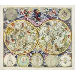
Planisphaerium Coeleste.
Magnificent double hemisphere celestial chart showing the northern and southern sky with constellations in allegorical form derived from Hevelius.A diagram in the upper l...
Place & Date: Augsburg, 1730
![[Page with imaginary towns in Hungary. ] CCLXVIII](/uploads/cache/26932-250x250.jpg)
[Page with imaginary towns in Hungary. ] CCLXVIII
Page with imaginary towns in Hungary (230x225mm.) This leaf is from an edition of Hartmann Schedel's Liber chronicarum or Nuremberg Chronicle. The Chronicle was published...
Place & Date: Nuremberg, 1493

Nuova carta dell' Imperio della Chia e dei Paesi circonvicini. / Nueva carta de l'Impario de la Quina.
The map is of interest for the use of Mar di Corea" and "Mar Setentrionale del Giapone" in the sea between Korea and Japan.Rare early edition of Albrizzi's...
Place & Date: Venice, 1740
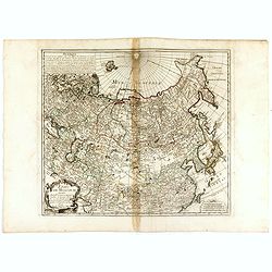
ETATS DE MOSCOVIE.
A detailed map of the Russian Empire West to East from Poland, Finland to the Baring Strait and North to South from China to Spitzbergen. The Siberian coastline is based ...
Place & Date: Paris, 1744

La Saxe Contenant le Routes et les postes. . .
Fine post-route map of Saxony in Germany with a splendidly engraved title cartouche. The map is centered on Leipzig. George Louis Le Rouge was active between 1740 and 178...
Place & Date: Paris, 1756

Habillement de l'Empereur de la Chine & des Dames de son Palais..
This impressive engraving is a wonderful example of Chatelain’s elegant plates.Divided in 3 panels, showing examples of costumes of Chinese ladies and those of the king...
Place & Date: Amsterdam, ca. 1728

Vue de la ville et du château de Heidelberg . . . Ansicht der stadt und des schlosses Heidelberger . . .
Engraving after Louis Charles François de Graimberg-Belleau. Engraved by Ch. Haldennvang.French artist. Son of Gilles-François Belleau Graimberg. Louis Charles Françoi...
Place & Date: Graimberg, Heidelberg, ca. 1840

Insulae Indiae Orientalis.
Map of South East Asia with good detail on the Philippines from the rare Cloppenburg edition slightly larger format and more scarce edition of the Mercator/Hondius "...
Place & Date: Amsterdam, 1630

Ormus
A lovely map of miniature map the Kingdom of Ormus, published by Petrus Bertius, and published in Amsterdam at the beginning of the seventeenth century. With an attractiv...
Place & Date: Amsterdam, 1606
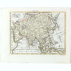
Asia.
Detailed map the Asian continent. The map is of interest for the use of Sea of Corea, the sea between Korea and Japan.
Place & Date: Amsterdam, 1682
Selling price: $225
Sold in 2023
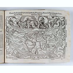
Cosmographie, ou description des quatre parties du Monde...
Fourth French edition (first French collective edition), considerably enlarged with the double-page truncated cordiform world map "Charte cosmographique", in us...
Place & Date: Antwerp, Jean Bellere, a l'Aigle d'Or, 1581
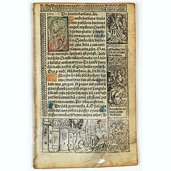
Leaf on vellum from a printed Book of Hours.
24 lines of printed text, surrounded by renaissance borders decorated with flowers, vases and religious scenes.From the press of the leading Parisian publisher and illumi...
Place & Date: Paris, Germain Hardouyn, c.1520-1540
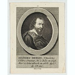
M.Merian, l'Ancien célébre graveur . . .
Portrait of Matthäus Merian (1593-1650) by Hubert. Matthäus Merian der Ältere was a Swiss-born engraver who worked in Frankfurt for most of his career, where he also ...
Place & Date: Paris, 1784
Histoire de la Navigation.
A fine example of Linschoten's classic illustrated travelogue to the East and West Indies, termed by Lach “the most important of the firsthand accounts published indepe...
Place & Date: Amsterdam, Evert Cloppenburgh, 1638

Chaerte vande Wieringer waert, de welcke inden jaere XVI… (Wieringerwaard)
Rare wall map of the Wieringerwaard polder, as raffled on 12 July 1611. The polder was laid dry in 1610. It border, and also the border of the municipality, were the Zuid...
Place & Date: 1741-1744
![[Lot of 4 charts] Plan de la Baie et du Port de Camraigne / Plan de la Baie de Niatrang et du Golfe de Binkang / Plan de la Cote de Cochinchine. . . / Plan des Ports de Xuandai, Vung-Lam. . .](/uploads/cache/44795A-250x250.jpg)
[Lot of 4 charts] Plan de la Baie et du Port de Camraigne / Plan de la Baie de Niatrang et du Golfe de Binkang / Plan de la Cote de Cochinchine. . . / Plan des Ports de Xuandai, Vung-Lam. . .
[A set of four French sea charts numbered consecutively]. A set of 4 basic coastal sea charts of parts of southern French Indochina (Vietnam).Chart 295 centers on the reg...
Place & Date: Paris ca 1780
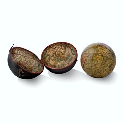
Globe, Miniature, Terrestrial Pocket Globe in Celestial Case
A pocket globe, of typical form, the terrestrial globe with engraved hand-colored gores, having holes at the poles but no axis pins (as issued). The globe is contained wi...
Place & Date: London, ca. 1780

Provincie Noord-Braband. / Breda, de Langstraat. . .
Decorative and uncommon custume plate lithographed by R. de Vries and published by Frans Buffa & Zonen in Amsterdam. A group of 4 women from the area of Baronie van B...
Place & Date: Amsterdam, 1857
![Figure 27 deuxieme partie a gauche.. [Hors riding].](/uploads/cache/14160-250x250.jpg)
Figure 27 deuxieme partie a gauche.. [Hors riding].
This fabulous illustration depicts formal movements of equitation for horse riding school movements. The print shows both A.de Pluvinel and the future King at the age of ...
Place & Date: Paris, 1629
![Figure 38 troisieme partie. [Hors riding]](/uploads/cache/14164-250x250.jpg)
Figure 38 troisieme partie. [Hors riding]
This fabulous illustration depicts formal movements of equitation for horse riding school movements. The print shows both A.de Pluvinel and the future King at the age of ...
Place & Date: Paris, 1629
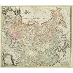
Imperii Russici et Tartariae Universae tam majoris Afiaticæ quam minoris et EuropæTabula.
The map is of interest for the use of Mere Orientale Minus Corea for the sea between Korea and Japan.Decorative map covering Russia, Tibet, China, Tartary, Korea, Taiwan ...
Place & Date: Nuremberg, 1739

Simori.
Portrait of Simori.Von Siebold was born in Wurtzburg, in Germany, and worked for the Dutch government as a doctor in Java. In Japan, where Von Siebold arrived in 1823 at ...
Place & Date: Leiden, 1832-1852

Globe Terrestre Didié et Présénté a Monseigneur le Comté Maubec de Brancas...
Terrestial globe dated 1741. Complete title "Globe Terrestre Didié et Présénté a Monseigneur le Comté Maubec de Brancas Par Jacque Hardy. Dressé sur ...
Place & Date: Paris, dated 1741

Forest scene on the Tobihanna Alleghany Mountains.
Original aquatint engraving for Travels in the Interior of North America between 1832-34 . Engraved by L.Weber. The finest work on American Indian life and the American F...
Place & Date: London/Paris/Coblenz, 1839
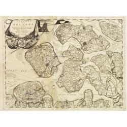
Contado di Zelanda..
A most attractive and decorative map by Vincenzo Coronelli. An elaborate title cartouche garlanded with intertwined flowers and dedicated to Vincenzo Caualli. The remarka...
Place & Date: Venice 1692
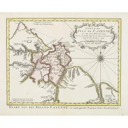
Carte de L'Isle de Caiene et de ses environs.
Uncommon edition of this accurate map of Cayenne. In lower right engraved "31."From Atlas Portatif pour servir a l'intelligence de l'Histoire Philosophique et P...
Place & Date: Amsterdam, 1773
![[Perspective print after J. Vredeman de Vries. ]](/uploads/cache/26445-250x250.jpg)
[Perspective print after J. Vredeman de Vries. ]
Engraving depicting the use of the vanishing point. From Les cinq rangs de l'architecture, a savoir, Tuscane, dorique, ionique, corinthiaque et composée avec l'instructi...
Place & Date: The Hague, 1606