Browse Listings in Asia > India > Sri Lanka (Ceylon)
![.Taprobana Ins. Tabula XII Asiae. [Sri Lanka.]](/uploads/cache/27928-250x250.jpg)
.Taprobana Ins. Tabula XII Asiae. [Sri Lanka.]
Ptolemy's mythical island of Taprobana originally became associated with Sri Lanka although it was sometimes confused with Sumatra. Taprobana, as it was called on most ea...
Date: Lyons, M. Servetus, 1535

Maldivae Insulae.
Very fine early miniature map of Maldives Islands. East is at the top. Title cartouche on the lower right corner. A dolphin and two ships are depicted.First published in ...
Date: Amsterdam / Frankfurt, 1609
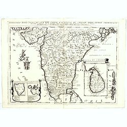
Penisola dell'Indo di qua del Gange, e l isola di Ceilan..
India below the Tropic of Cancer, with an inset of Ceylon and Trincomalee.The remarkable Vincenzo Coronelli (1650-1718), encyclopaedist, geographer, inventor and Doctor o...
Date: Venice, 1698
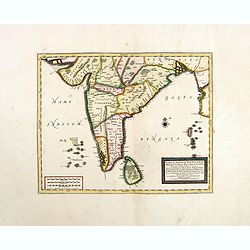
Carte du Golfe de Bengale, Mer de Indes, et Riviere du Gange, Avec les Pais et Iles d'alentour, Savoir les Cotes de Malabar, Cormandel, Ile de Ceylon, Les Maldives . . .
Detailed map of the Southern part of India with Ceylon. Good detail along the coasts of Malabar, Coromandel, the Maldives islands and the Kingdoms of Visipour, Golconda, ...
Date: Leiden, 1719
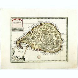
Isola Ceilon.
Attractive copper engraved map of Sri Lanka showing mountains, Towns and the Rama's Bridge (Ponte di Adamo). Included in "Atlante Novissimo che Contiene Tutte le Par...
Date: Venice, 1740

De Zuydwest-Kust van Het Eyland Ceylon.
A finely engraved and detailed chart of Nilwella / Kudawella Harbor.Very rare: only included in the 6th volume (so-called secret atlas) of Van Keulen's. A lettered key in...
Date: Amsterdam, 1753

Outposts of Empire. Ceylon.
A large colored lithograph by John Vickery (1906-1983), he was an Australian artist. He worked in the fields of painting, illustration and advertising. He is the only Aus...
Date: London, ca 1937
