![[East Asia]](/uploads/cache/33873-250x250.jpg)
[East Asia]
Wood block printed map and one of earliest printed representation of East Asia and centered on Amenia, prepared Martin Waldseemüller. Based on the slightly larger map fr...
Date: Vienna, 1525 -1541

Tafel der Lender darin der Apostel Paulus geprediget hat.
Rare wood block map depicting the Mediterranean, with an over-sized Cyprus from the final Dutch edition of Heinrich Bünting's famous Itinerarium Sacrae Scripturae, a boo...
Date: Magdeburg, 1581

Terrae Yemen Maxima Pars, seu Imperii Imami, Principatus Kaukeban nec non ditionum Haschid u Bekil, Nehhm, Chaulan, Abu Arisch et Aden Tabula ...
South-west Arabia, with the Saudi Arabian city of Jizan south to Aden. With a fine title, cartouche. Based on a map by Carsten Niebuhr. With the name Sinus Arabicus Mare ...
Date: Augsbourg, 1774
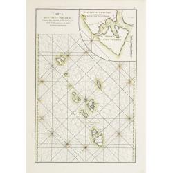
Carte des Isles Nicobar... (with) Plan particulier du Port compris entre les Isles Nacaveri, Souri, et Tricutte.
French chart of Isles of Nicobar in Gulf of Bengal near Birmanie and Sumatra. Prepared by Jacques-François L'Abbé Dicquemare (1733-1789). Latitude and longitude scales,...
Date: Paris, Brest, chez Demonville, 1775
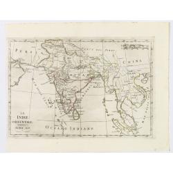
Le Indie Orientali.
A nice map of the East Indies, published in Rome at the beginning of the nineteenth century. Shows from the Persian Gulf across Pakistan, India, and Bangladesh, then sout...
Date: Rome, ca 1803
