Browse Listings in America > South America > Magallan / Tierra del Fuego
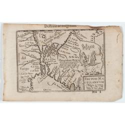
Fretum Magellanicum / Detroit de Magellan.
Early nice map of the South American extremity with the Strait of Magallanes, discovered by Ferdinand Magellan ( c. 1480 – 27 April 1521). Two natives holding a shield ...
Date: Amsterdam, 1606
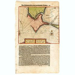
Caarte vande nieuwe Passagie bezuijden de Strate Magellan. . . / Description de nouveau passage vers le zud du destroit de Maggellan. . .
Map showing the new route around the bottom of South America discovered by Schouten and Le Maire: through the Le Maire Strait, around the Barnevelt Islands, and past Cape...
Date: Frankfurt am Main, 1619
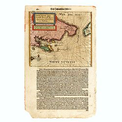
Sudseite des Landts Terza del Fuoco, abgezeichnet durch Iohan von Walbeck.
Map showing Cap Horn and the Terra del Fuego.From a German text edition of Theodor de Bry's travel book. The original copper plate is now shortened at the left side and h...
Date: Frankfurt am Main, 1630
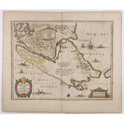
Freti Magellanici ac novi Freti vulgo Le Maire. . .
A fine map of Tierra del Fuego. With an explanatory text of the passage by Barent Jansz. Potgieter, who accompanied Captain Sebald de Weert to the Straits in 1599/1600, w...
Date: Amsterdam, ca. 1633

Rivage du port Saint-Nicolas.
Exquisite contemporary colored lithograph of Port Saint-Nicolmas Bay in most southern part of South America, with Dumont D'Urville's officers making landfall. Drawn by E....
Date: Paris, 1846
