Please login to see price!.
Subscribe to be notified if similar examples become available.
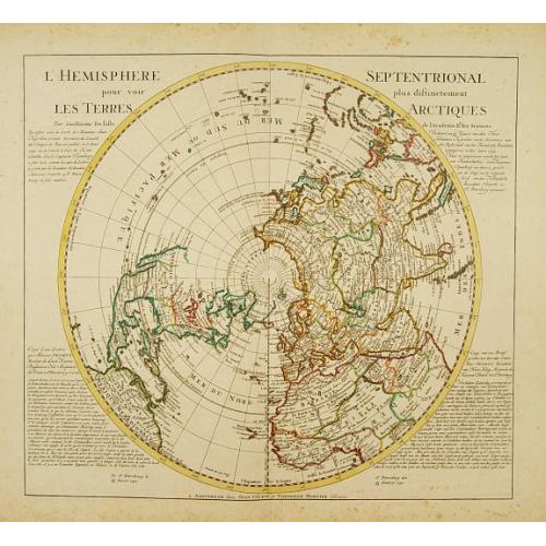
L'Hemisphere Septentrional pour voir plus distinctement les Terres Arctiques. |
||||||||||||||||||||
|
||||||||||||||||||||
|
|
||||||||||||||||||||
|
|
Virtual Collection - Save and collect this or any of your favorite items in one place.
If you want to save the items permanently, please sign in or create account first. |
|||||||||||||||||||
Description
Decorative map depicting from the northern pole to the Equator with good detail, and showing all the political divisions. California is correctly shown as a peninsula with the entire northwest coast blank above Cap Mendocino.
Near the northern coast of Asia is Terre de la Compagnie with a note about its discovery by Jean de Gama. Covens & Mortier's edition of De L'Isle's map of the Northern Hemisphere ratified to include the Kamchatka peninsula. Presents the copy of a letter concerning the discovery of 34 islands by the captain Spanberg.
This important map, originally produced by Guillaume Delisle in 1714, was published by Covens and Mortier. The map went through several revisions, this is the more desirable issue with annotations written in French and Dutch beside the hemisphere.
The map is of interest for the use of the sea between Korea and Japan, here called "Mer Orientale".
North America is drawn as it appeared at the height of the Colonial period. English colonies skirt the east coast, the French control the Great Lakes regions and Louisiana, and the Spanish dominate in Mexico, California and the Southwest. California is drawn connected to the mainland with a dotted line - indicating that European map publishers were not yet prepared to give up on the idea that California may indeed be an Island.
Names the city of Quivara, which is one of the lands associated with Spanish legends of the Seven Cities of Gold. Also notes the Sioux and the Apalache peoples. As befits De L'Isle's scientific approach to cartographer much of the unexplored northwest of America remains blank.
By contrast the northeast parts of Asia, which had recently been explored by Vitus Bering and Tschirikow, offer a number of interesting elements. The land of Compagnie is shown just the east of Yedso (likely Hokkaido) with a note regarding its mysterious discovery by Jean de Gama. Often called de Gamma Land or Gama, this island was supposedly discovered in the 17th century by a mysterious figure known as Jean de Gama. Various subsequent navigators claim to have seen this land, but it was left to Bering to finally debunk the myth. In 1729, he sailed for three days looking for Juan de Gama land but never found it. Thought it may be little more than a mis-mapping of Hokkaido or the Japanese Kuriles, Gama or Compagnie remained on maps for about 50 years following Bering's voyages until the explorations of Cook confirmed the Bering findings.
Japan itself is only vaguely mapped though Edo (Yendo) is indicated. Just to the west the Peninsula of Korea is drawn with a fairly accurate if slightly bulbous form. Further south Formosa and the Philippines are well mapped.
Reference: Wagner, H. R., The Cartography of the Northwest Coastof America to the Year 1800, #504
FAQ - Guarantee - Shipping
Buying in the BuyNow Gallery
This item is available for immediate purchase when a "Add to Cart" or "Inquire Now" button is shown.
Items are sold in the EU margin scheme
Payments are accepted in Euros or US Dollars.
Authenticity Guarantee
 We provide professional descriptions, condition report (based on 45 years experience in the map business)
Paulus Swaen warrants the authenticity of our items and a certificate of authenticity is provided for each acquired lot.
Condition and Coloring
We indicate the condition of each item and use our unnique HiBCoR grading system in which four key items determine a map's value: Historical Importance, Beauty, Condition/Coloring and Rarity.
Color Key
We offer many maps in their original black and white condition. We do not systematically color-up maps to make them more sellable to the general public or buyer.
Copper engraved or wood block maps are always hand colored. Maps were initially colored for aesthetic reasons and to improve readability. Nowadays, it is becoming a challenge to find maps in their original colors and are therefor more valuable.
We use the following color keys in our catalog:
Original colors; mean that the colors have been applied around the time the map was issued.
Original o/l colors; means the map has only the borders colored at the time of publication.
Colored; If the colors are applied recently or at the end of the 20th century.
Read more about coloring of maps [+]
Shipping fee
A flat shipping fee of $ 30 is added to each shipment by DHL within Europe and North America. This covers : International Priority shipping, Packing and Insurance (up to the invoice amount).
Shipments to Asia are $ 40 and rest of the world $50
We charge only one shipping fee when you have been successful on multiple items or when you want to combine gallery and auction purchases.
Read more about invoicing and shipping
FAQ
Please have a look for more information about buying in the BuyNow gallery
Many answers are likely to find in the general help section.
Virtual Collection
![]()
With Virtual Collection you can collect all your favorite items in one place. It is free, and anyone can create his or her Virtual map collection.
Unless you are logged in, the item is only saved for this session. You have to be registed and logged-in if you want to save this item permanently to your Virtual Collection.
Read More[+]
Register here, it is free and you do not need a credit card.
Add this item to
Virtual Collection
or click the following link to see my Virtual Collection.
| Digital Image Download | |
|
Paulus Swaen maintains an archive of most of our high-resolution rare maps, prints, posters and medieval manuscript scans. We make them freely available for download and study. Read more about free image download |
Click the image for a free small image download. |
In accordance with the EU Consumer Rights Directive and habitually reside in the European Union you have the right to cancel the contract for the purchase of a lot, without giving any reason.
The cancellation period will expire 14 calendar days from the day after the date on which you or a third party (other than the carrier and indicated by you) acquires, physical possession of the lot. To exercise the right to cancel you must inform Paulus Swaen Inc, of your decision to cancel this contract by a clear statement (e.g. a letter sent by post, or e-mail (amsterdam@swaen.com).
To meet the cancellation deadline, it is sufficient for you to send your communication concerning your exercise of the right to cancel before the cancellation period has expired.
