Subscribe to be notified if similar examples become available.
Description de l'Empire de la Chine et de la Tartarie chinoise. |
||||||||||||||||||||
|
||||||||||||||||||||
|
|
||||||||||||||||||||
|
|
My Collection +
Add this or any of your favorite items in one place. If you want to save the items permanently, you have to sign in or create an account first. |
|||||||||||||||||||
Description
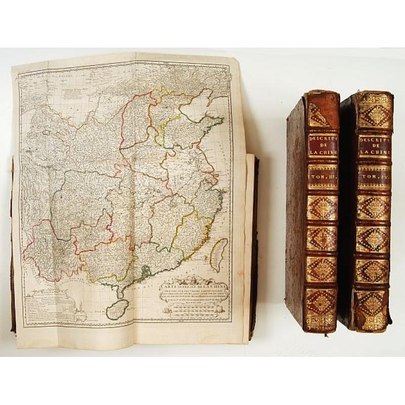
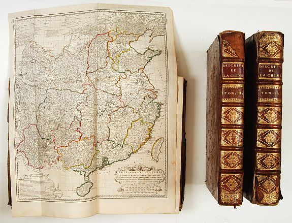
Titles printed in red and black and incorporating an engraved pictorial vignette by Baquoy after Humblot, fine engraved maps (many folding) and plates, text printed in double-columns and decorated with many woodcut head- and tail-pieces and typographic ornaments.
First Edition.
The general maps have original out-line color.
Volume I: With a large folding map of China and Taiwan and a great number of maps of Chinese Provinces.
Volume III: with plate of Chinese scientists, and several more showing plans.
Volume IV: With a large folding map of China/Tartary and a map of Corea (The first separate map of the peninsular). Maps of Tartary and Tibet.
Du Halde's beautifully printed and splendidly illustrated work is the summation of European knowledge on China in the 18th-century. It was begun by the Jesuit missionaries to China in 1708, and their completed manuscripts were presented to the Emperor Kang-hi in 1718. Kang-hi ordered further surveys and from them were constructed the well-known maps forwarded to father Du Halde and used by d'Anville for this work.
Because the principles and methods of surveying had greatly improved by the late 17th- and early 18th-centuries, the result was the most accurate mapping of China available in Europe at the time.
The maps are by Jean Baptiste Bourguignon d?Anville (1697-1782), ?the finest cartographer of his time? (Moreland & Bannister: Antique Maps, p.133).
For certain remote parts of northern China, Mongolia and Tibet, this work was the only adequate reference until the technological revolution in surveying in the 20th-century. In addition to the information on China, Du Halde's work includes highly important material on Alaska: Relation succincte du voyage du Capitaine Beerings dans la Siberie, appearing in vol. IV, is the first printed report of Bering's 1725-28 expedition.
The accompanying map Carte des Pays traversés par le Capne Beerings contains the first printed configuration of any part of Alaska, namely St. Lawrence Island. Both the report and map are based on manuscripts that Bering had presented to the King of Poland who, in turn, presented them to Du Halde for inclusion in this work.
Lada-Mocarski reports that in many copies pp. 451-2 in vol. IV have been supplanted by the map: in this copy, both are present.
References : Lada-Mocarski: Bibliography of Books on Alaska, #2 pp. 20-22: Cox I, p. 335: Cordier: Bibliotheca Sinica, I pp. 30-31: Wagner p. 156: Wroth: Early Cartography of the Pacific, 91.
FAQ - Guarantee - Shipping
Buying in the BuyNow Gallery
This item is available for immediate purchase when a "Add to Cart" or "Inquire Now" button is shown.
Items are sold in the EU margin scheme
Payments are accepted in Euros or US Dollars.
Authenticity Guarantee
 We provide professional descriptions, condition report (based on 45 years experience in the map business)
Paulus Swaen warrants the authenticity of our items and a certificate of authenticity is provided for each acquired lot.
Condition and Coloring
We indicate the condition of each item and use our unnique HiBCoR grading system in which four key items determine a map's value: Historical Importance, Beauty, Condition/Coloring and Rarity.
Color Key
We offer many maps in their original black and white condition. We do not systematically color-up maps to make them more sellable to the general public or buyer.
Copper engraved or wood block maps are always hand colored. Maps were initially colored for aesthetic reasons and to improve readability. Nowadays, it is becoming a challenge to find maps in their original colors and are therefor more valuable.
We use the following color keys in our catalog:
Original colors; mean that the colors have been applied around the time the map was issued.
Original o/l colors; means the map has only the borders colored at the time of publication.
Colored; If the colors are applied recently or at the end of the 20th century.
Read more about coloring of maps [+]
Shipping fee
A flat shipping fee of $ 30 is added to each shipment by DHL within Europe and North America. This covers : International Priority shipping, Packing and Insurance (up to the invoice amount).
Shipments to Asia are $ 40 and rest of the world $50
We charge only one shipping fee when you have been successful on multiple items or when you want to combine gallery and auction purchases.
Read more about invoicing and shipping
FAQ
Please have a look for more information about buying in the BuyNow gallery
Many answers are likely to find in the general help section.
My Collection+
![]()
With My Collection+ you can collect all your favorite items in one place. It is free, and anyone can create his or her virtual collection.
Unless you are logged in, the item is only saved for this session. You have to be registed and logged-in if you want to save this item permanently to My Collection+.
Read More[+]
Register here, it is free and you do not need a credit card.
Add this item to
My Collection+
or click the following link to see My Collection+.
| Digital Image Download | |
|
Paulus Swaen maintains an archive of most of our high-resolution rare maps, prints, posters and medieval manuscript scans. We make them freely available for download and study. Read more about free image download |
Click the image for a free small image download. |
In accordance with the EU Consumer Rights Directive and habitually reside in the European Union you have the right to cancel the contract for the purchase of a lot, without giving any reason.
The cancellation period will expire 14 calendar days from the day after the date on which you or a third party (other than the carrier and indicated by you) acquires, physical possession of the lot. To exercise the right to cancel you must inform Paulus Swaen Inc, of your decision to cancel this contract by a clear statement (e.g. a letter sent by post, or e-mail.
To meet the cancellation deadline, it is sufficient for you to send your communication concerning your exercise of the right to cancel before the cancellation period has expired.
