
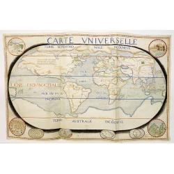

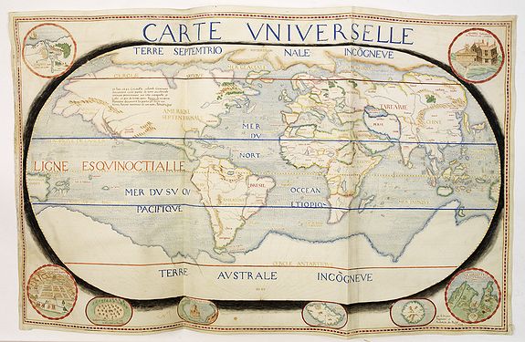
Carte Universelle, signed 'par S.de Caus Ingenieur et Architecte du Roy 1624 |
||||||||||||||||||||
|
||||||||||||||||||||
|
|
||||||||||||||||||||
$600000 / ≈ €510665This item is available for immediate sale! Questions before Buying ?
We are happy to answer your questions.
600000.00
|
Virtual Collection - Save and collect this or any of your favorite items in one place.
If you want to save the items permanently, please sign in or create account first. |
|||||||||||||||||||
Description
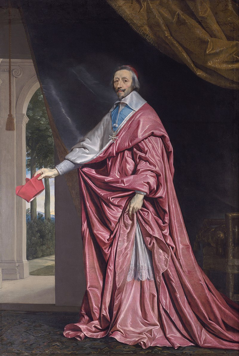
A magnificent manuscript map of the world, probably made for Cardinal
Richelieu (1585-1642), the “father of the modern state system” (Kissinger),
given the author and content. The map was drawn in 1624, the year in which Richelieu was made principal minister to Louis XIII of France, and de facto ruler of the country. He occupied this position until his death.
Richelieu was keen to expand the power of the French navy, realizing that it was essential to establishing France as a global power.
Richelieu came from a maritime family and wrote in a memorandum, “It has been till now a great shame that the king who is the eldest son of the Church is inferior in his maritime powers to the smallest prince in Christendom” (Knecht).
His efforts began in the year this map was created, with the establishment of a Conseil de Marine to present naval proposals to the king’s council.
At the time, there was no permanent fleet in the Atlantic and a handful
of galleys in the Mediterranean; a decade later, there were three squadrons
of round ships in the Atlantic, and one in the Mediterranean. Richelieu
was spurred on in his efforts by the Protestant privateers blocking Catholic
towns on the Atlantic coast during the Wars of Religion and the Huguenot
Rebellions, and the subsequent loss of much of the Atlantic trade to the
English and Dutch ( James).
In line with France’s new outward-looking foreign policy, the map
shows the global reach and ambitions of the French empire. It concentrates
in particular on New France in the Americas, which in 1624 included
the shores of the St. Lawrence River, Newfoundland, and Nova Scotia
(Arcadia), shown on the map as ‘Canada’ and ‘Estotiland’. ‘Virginne’
(Virginia) and ‘Floride’ (Florida), also appear. Amongst the vignettes in
the margin is an early image of an ‘habitation en Virginie et floride’ and
an Indian village in Virginia, drawn after Theodor de Bry (who published
some of de Caus’ works). Another vignette, ‘Quebec habitation de francois
en Canada’, is drawn after the travel account of Samuel de Champlain.
Generally speaking, the cartography is based on that of Jean le
Clerc’s second separately issued world map, engraved by Jodocus Hondius,
and published in Paris in 1602. However, de Caus’ map includes some
important updates, including in Le Maire’s Strait and in northern Canada,
where the results of Champlain’s expedition ten years earlier are shown.
Richelieu had a particular interest in the French territory of New France, now known as Canada.
In 1627, he authorized an association of merchants, the Compagnie de la
Nouvelle-France, popularly known as the Compagnie des Cent-Associes,
or The One Hundred Associates, to take all steps it might think expedient
for the protection of the colony and the expansion of trade and commerce,
including a complete monopoly on the fur trade. Both Richelieu and
Champlain were members.
Richelieu was the nominal governor of New
France, but Champlain was appointed acting governor. Apart from a
brief interruption when the English blockaded the Saint Lawrence River and captured Quebec between 1629 and 1633, the Compagnie remained proprietor of New France until 1663.
In all, 17 settlements are shown on the map: Rome, ‘Mecha’ (Mecca),
Mosco(w), Constantinople, Quebec, Quinsay (Hangchow), Beijing,
Jerusalem, ‘La Babylone’, ‘Mexique’ (Mexico City), Leon, Lima, Cusco,
‘Arica Potosi’, ‘ville de la plate’, ‘Fernanborg’ (in Brazil), and ‘Cambalu’
(in Cathay). Regional names and tribal names appear in red and gold. Those locations of most interest to the French are depicted in eight
roundels, each a small masterpiece, in the margin of the map: a map of
the port of Havana, with tall ships in the harbor, ‘Havane port en lisle de
Cube’; the fortified citadel of ‘Quebec - habitation de francois en Canada’;
maps of ‘La Goulette surla coste de barbarie pres de tunis’, ‘Isle St. Thomas’,
Rodes’, ‘Penon de Velez’; an important and early view of an Indian village
in Virginia, ‘habitation en Virginie et floride’; and of ‘Cusco ville metropolitaire
du Peru’.
Jean Salomon de Caus (1576-1626) was an architect, engineer,
mathematician and author. He is known not only for his works, but also
for his extensive writings on how he achieved them, including ‘Hortus
Palatinus’ (1620) on his Heidelberg garden designs, and ‘Les raisons des
forces mouvantes’ (1615) on the principles of hydraulics behind the
automata and fountains in his gardens.
De Caus’ influence was widespread in the courts of the Southern
and Northern Netherlands, Germany, and England, where his younger
brother Isaac de Caus (1590-1648) worked, long before he became
‘Ingenieur et Architecte du Roy’ for Louis XIII. James I brought him to
the English court as drawing master to his children, Elizabeth and Henry
Frederick. At the palace of Richmond, he created amusing fountains and
other novel waterworks for the ailing Henry Frederick. On his death, in
1612, de Caus left England. It was for Elizabeth, when she married Elector
Friedrich V, that de Caus created the design of the Hortus Palatinus in
Heidelberg, begun in about 1614 and left unfinished in 1619.
De Caus arrived in France in 1620, at first in Rouen and then in
Paris. He first worked for Louis XIII as a hydraulic engineer, responsible
for sanitation and water supply.
In the records, there are a few maps attributed to Salomon de Caus. During the last years of his life, de Caus also worked as a cartographer. In approximately 1622, he created a plan of Paris, as discussed in “De Vitruve”; however, the map is now lost or its whereabouts are unknown. (Nature as Model, page 64) Two other maps by de Caus are mentioned in the literature; one is a world map, the existence of which was first mentioned by J.Desnoyers in 1870. Maks has dated this map to about 1620-21 because it is signed “S.de Caus, ingénieur du roy.” Another map by de Caus’s hand (and signed in the same way) appeared on the London art market on 30 June 1980 and is inscribed “Pour Monseigneur le Cardinal de Richelieu”.
His interest in cartography reflects, perhaps more than anything, his origins. During the sixteenth century, Dieppe was a leading center of map-making, hydrography, and the science of navigation. The corsair Jean Doublet, for instance, has left a description of his studies in this field with a local priest: “He started me off with the principles of the sphere, tides, elevations, the handling of the quadrant, the English scale... as well as sines, tangents and logarithms. Whereupon he asked me what I wanted to do, since I was talking so much theory and practice with him. I told him that I wanted to perfect myself with a capable master, and so would he be good enough not to spare any pains on me. He taught me the spherical triangles and the Elements of Euclid and calculation”. De Caus was as well informed in this field as he was in others. Indeed, it is possible that his background in navigation and cartography was acquired in his home city: there would, after all, have been few better places for studies.
See : Luke Morgan, Nature as Model: Salomon de Caus and Early Seventeenth-Century Landscape Design (Penn Studies in Landscape Architecture).
There was extensive contact between Salomon de Caus and Cardinal Richelieu , in the same year, 1624 as our map, Salomon de Caus drew a map of Italy for Richelieeu, showing the Alps, Corsica and Sardinia, and dedicated his last major treatise, “ La pratique et demonstration des horloges solaires”, published at the presses of Jerôme Drouart to the new ruler of France. This dedication does refer to a map of Italy: "L’opinion qu’on pourrait avoir, que vous me portez plus d’affection que mes services n’en ont pu encore mériter, me donnent sujet de mettre souvent le compas & la règle en main, pour tâcher à m’acquitter du service que je vous dois...". It ends with a request: "Je vous prie donc, Monseigneur, de recevoir ce petit œuvre, attendant qu’il vous plaise me commander choses plus grandes, où j’espère m’acquitter de mon devoir…". We do not know why Salomon de Caus recognized being in debt to the cardinal.‘La pratique et demonstration des
horloges solaires’ or "The practice and demonstration of solar clocks, etc." was published in Paris in 1624, and in which he deals with cosmography more than in any other of his writings, is dedicated to Cardinal Richelieu. We can read in the dedicatory epistle that the author often puts the compass and the ruler in his hand, to try to fulfill the service he owes him. We can therefore presume, with great probability, that Salomon de Caus is alluding to his studies in geography, and that he was still working on this world map, which remained unpublished, shortly before his death, that is to say from 1624 to 1626. " (Benjamin Ravier, Voir et concevoir : les théâtres de machines, Université Paris 1 Panthéon-Sorbonne.
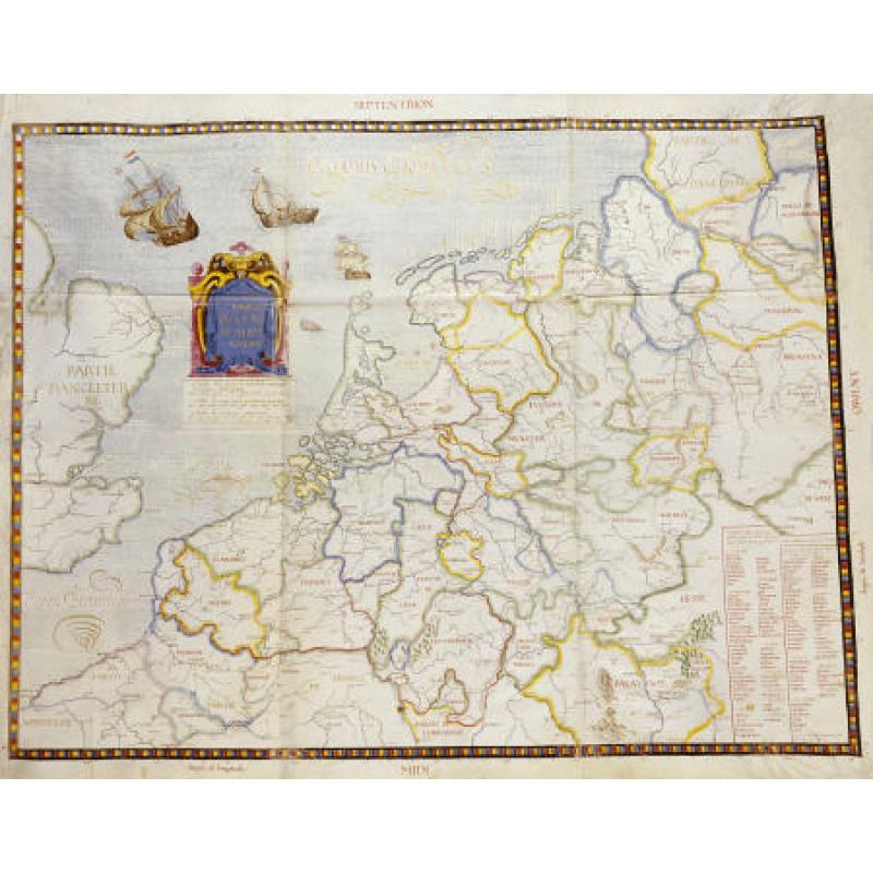
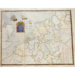
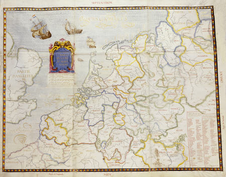
Another manuscript map with the signature of de Caus is recorded. "Les Paiis Bas ou la Basse Alemaigne...memoire des villes principalles que le Roy Despagne tient au pays bas en ceste annee 1624 15eme mars..memoire des villes que Messrs Les Estats tiennent signed 'par S.de Caus Ingenieur et architecte du Roy
This illumunated manuscript map on a single vellum sheet, ink and wash, 640 x 810mm., the map depicting the states of Germany and the Low Countries, as well as the Eastern portion of England.
Numerous towns indicated by settlement symbols, regions delineated by wash outlines, rivers in blue, place-names in sepia, regional names in red, countries and seas in gold. The waters are decorated with wavy blue lines, three ships (flying the French flag) and a sea monster. The title is set in the North Sea as a tableau cartouche with scale bars below, surrounded by ruled sepia borders with multi-colored infills, and inset tables of the principal towns at the lower right corner.
Richelieu, New France and the Dutch West India Company
Richelieu was keen to expand the power of the French navy, realizing that it was essential to establishing France as a global power. When Richelieu came to power, New France 5canada), where the French had a foothold since Jacques Cartier, had no more than 100 permanent European inhabitants.
Richelieu encouraged Louis XIII to colonize the Americas by founding the Compagnie de la Nouvelle France, in imitation of the Dutch West India Company (W.I.C.) In his "Testament politique", Richelieu wrote « le miracle hollandais » en ces termes : « L'opulence des Hollandais qui, à proprement parler, ne sont qu'une poignée de gens, réduits en un coin de terre, où il n'y a que des eaux et des prairies, est un exemple et une preuve de l'utilité du commerce qui ne reçoit point de contestation »[Netherlands, with its V.O.C. and W.I.C., was so an excellent example for the Cardinal, and that could be the reason he commissioned a map of the Low Countries with de Caus.
(1) Desnoyers Jules. Une mappemonde autographe de Salomon de Caus. In: Comptes rendus des séances de l'Académie desInscriptions et Belles-Lettres, 19ᵉ année, N. 3, 1875. pp. 193-195;
M. Desnoyers a la parole pour une communication relative à une mappemonde autographe de Salomon de Caus.
«Je me proposais, dit-il, d'avoir l'honneur de communique aujourd'hui à l'Académie la description d'une mappemonde manuscrite sur parchemin, signée par S. (Salomon) de Caus, ingénieur du Roy, mappemonde que je possède depuis plusieurs années.
Mais désirant présenter cette carte à l'Académie à l'appui de ta description détaillée que j'en donnerai, j'ai dû différer jusqu'après l'exposition du Congrès de géographie , où elle figure.
« Je me bornerai à dire aujourd'hui que cette mappemonde est incontestablement de la main du céfèbre ingénieur qui l'a signée.
La comparaison de l'écriture du plus grand nombre des inscriptions de la carte avec les rares autographes jusqu'ici connus de Salomon de Caus ne peut laisser à cet égard aucun doute. Il en est de même de l'état des connaissances géographiques qu'elle dénote chez son auteur.
Si l'on compare cette carte aux mappemondes des géographes les plus connus de la fin du xvie et du commencement du xvne siècle, particulièrement d'Ortels et de Hondts, si justement illustres sous les noms savants d'Ortelius et de Hondius, on voit qu'elle est conforme à l'état des connaissances géographiques les plus répandues à cette époque, quoiqu'elle soit incomplète et inachevée.
Le titre de géographe du Roy (Louis XIII) , que prend Salomon de Gaus, fixe, avec une certitude presque complète, la date de la rédaction de la mappemonde, puisque l'auteur n'a reçu et
porté ce titre que depuis son retour définitif en France, en 1620 ou 1621. On connaît la date de sa mort en 1626. Son dernier ouvrage imprimé : La pratique et démonstration des horloges solaires, etc.
(1 vol, in-f° publié à Paris en 16 24, et dans lequel il s'occupe de cosmographie plus que dans aucun autre de ses écrits), est dédié au cardinal de Richelieu; or, on lit dans l'épître dédicatoire
que l'auteur met cr souvent le compas et la règle à la main , pour tâcher κ de s'acquitter du service qu'il lui doit, On peut donc présumer, avec une grande vraisemblance, queue Salomon de Caus fait allusion à ses études de géographie, et qu'il travaillait encore à cette mappemonde, qui est restée inédite, peu de temps avant sa mort, c'est-à-dire de 1624 à 1626.
«Il est permis d'ajouter aux nombreux titres qui ont fait à Salomon de Caus la réputation d'un ingénieur physician, hydrographe, architecte, musicien théoricien, etc., celui de géographe.
Il n'était, sans doute, pas besoin de ce nouveau renseignement pour achever de détruire le roman, auquel1 on a cru trop longtemps, de l'a prétendue Îofe de Salomon de Caras et de son in carcération par les ordres du grand ministre auquel il dédiait l'un de ses principaux ouvrages,
Reference: Jean-Vincent Blanchard, Éminence: Cardinal Richelieu and the Rise of France, (New York: Bloomsbury, 2011); Alan James, The Navy and government in Early Modern France 1572-1661 (Suffolk: Boydell and Brewer, 2004); Henry Kissinger, Diplomacy, (New York: Simon and Schuster, 1994); Robert J. Knecht, Richelieu, (Routledge, 2014); Richard Lodge, The Life of Cardinal Richelieu, (New York: A.L. Burt, 1903); Luke Morgan, Nature as Model: Salomon de Caus and Early Seventeenth-Century Landscape Design, (Philadelphia: University of Pennsylvania Press, 2006).
Richelieu was keen to expand the power of the French navy, realizing that it was essential to establishing France as a global power.
Richelieu came from a maritime family and wrote in a memorandum, “It has been till now a great shame that the king who is the eldest son of the Church is inferior in his maritime powers to the smallest prince in Christendom” (Knecht).
His efforts began in the year this map was created, with the establishment of a Conseil de Marine to present naval proposals to the king’s council.
At the time, there was no permanent fleet in the Atlantic and a handful of galleys in the Mediterranean; a decade later, there were three squadrons of round ships in the Atlantic, and one in the Mediterranean. Richelieu was spurred on in his efforts by the Protestant privateers blocking Catholic towns on the Atlantic coast during the Wars of Religion and the Huguenot Rebellions, and the subsequent loss of much of the Atlantic trade to the English and Dutch ( James).
In line with France’s new outward-looking foreign policy, the map shows the global reach and ambitions of the French empire. It concentrates in particular on New France in the Americas, which in 1624 included the shores of the St. Lawrence River, Newfoundland, and Nova Scotia (Arcadia), shown on the map as ‘Canada’ and ‘Estotiland’. ‘Virginne’ (Virginia) and ‘Floride’ (Florida), also appear. Amongst the vignettes in the margin is an early image of an ‘habitation en Virginie et floride’ and an Indian village in Virginia, drawn after Theodor de Bry (who published some of de Caus’ works).
Richelieu had a particular interest in the French territory of New France, now known as Canada. In 1627, he authorized an association of merchants, the Compagnie de la Nouvelle-France, popularly known as the Compagnie des Cent-Associes, or The One Hundred Associates, to take all steps it might think expedient for the protection of the colony and the expansion of trade and commerce, including a complete monopoly on the fur trade. Both Richelieu and Champlain were members.
Richelieu was the nominal governor of New France, but Champlain was appointed acting governor. Apart from a brief interruption when the English blockaded the Saint Lawrence River and captured Quebec between 1629 and 1633, the Compagnie remained proprietor of New France until 1663.
In all, 17 settlements are shown on the map: Rome, ‘Mecha’ (Mecca), Mosco(w), Constantinople, Quebec, Quinsay (Hangchow), Beijing, Jerusalem, ‘La Babylone’, ‘Mexique’ (Mexico City), Leon, Lima, Cusco, ‘Arica Potosi’, ‘ville de la plate’, ‘Fernanborg’ (in Brazil), and ‘Cambalu’ (in Cathay). Regional names and tribal names appear in red and gold.
Jean Salomon de Caus (1576-1626) was an architect, engineer, mathematician and author. He is known not only for his works, but also for his extensive writings on how he achieved them, including ‘Hortus Palatinus’ (1620) on his Heidelberg garden designs, and ‘Les raisons des forces mouvantes’ (1615) on the principles of hydraulics behind the automata and fountains in his gardens.
De Caus’ influence was widespread in the courts of the Southern and Northern Netherlands, Germany, and England, where his younger brother Isaac de Caus (1590-1648) worked, long before he became ‘Ingenieur et Architecte du Roy’ for Louis XIII. James I brought him to the English court as drawing master to his children, Elizabeth and Henry Frederick.
De Caus arrived in France in 1620, at first in Rouen and then in Paris. He first worked for Louis XIII as a hydraulic engineer, responsible for sanitation and water supply.
In the records, there are a few maps attributed to Salomon de Caus. During the last years of his life, de Caus also worked as a cartographer. In approximately 1622, he created a plan of Paris, as discussed in “De Vitruve”; however, the map is now lost or its whereabouts are unknown. (Nature as Model, page 64)
Another manuscript map with the signature of de Caus is recorded. "Les Paiis Bas ou la Basse Alemaigne...memoire des villes principalles que le Roy Despagne tient au pays bas en ceste annee 1624 15eme mars..memoire des villes que Messrs Les Estats tiennent signed 'par S.de Caus Ingenieur et architecte du Roy
This illumunated manuscript map on a single vellum sheet, ink and wash, 640 x 810mm., the map depicting the states of Germany and the Low Countries, as well as the Eastern portion of England.
Numerous towns indicated by settlement symbols, regions delineated by wash outlines, rivers in blue, place-names in sepia, regional names in red, countries and seas in gold. The waters are decorated with wavy blue lines, three ships (flying the French flag) and a sea monster. The title is set in the North Sea as a tableau cartouche with scale bars below, surrounded by ruled sepia borders with multi-colored infills, and inset tables of the principal towns at the lower right corner.
Richelieu was keen to expand the power of the French navy, realizing that it was essential to establishing France as a global power. When Richelieu came to power, New France 5canada), where the French had a foothold since Jacques Cartier, had no more than 100 permanent European inhabitants.
Richelieu encouraged Louis XIII to colonize the Americas by founding the Compagnie de la Nouvelle France, in imitation of the Dutch West India Company (W.I.C.)
M. Desnoyers a la parole pour une communication relative à une mappemonde autographe de Salomon de Caus.
«Je me proposais, dit-il, d'avoir l'honneur de communique aujourd'hui à l'Académie la description d'une mappemonde manuscrite sur parchemin, signée par S. (Salomon) de Caus, ingénieur du Roy, mappemonde que je possède depuis plusieurs années.
Mais désirant présenter cette carte à l'Académie à l'appui de ta description détaillée que j'en donnerai, j'ai dû différer jusqu'après l'exposition du Congrès de géographie , où elle figure. « Je me bornerai à dire aujourd'hui que cette mappemonde est incontestablement de la main du céfèbre ingénieur qui l'a signée.
La comparaison de l'écriture du plus grand nombre des inscriptions de la carte avec les rares autographes jusqu'ici connus de Salomon de Caus ne peut laisser à cet égard aucun doute. Il en est de même de l'état des connaissances géographiques qu'elle dénote chez son auteur.
Si l'on compare cette carte aux mappemondes des géographes les plus connus de la fin du xvie et du commencement du xvne siècle, particulièrement d'Ortels et de Hondts, si justement illustres sous les noms savants d'Ortelius et de Hondius, on voit qu'elle est conforme à l'état des connaissances géographiques les plus répandues à cette époque, quoiqu'elle soit incomplète et inachevée.
Le titre de géographe du Roy (Louis XIII) , que prend Salomon de Gaus, fixe, avec une certitude presque complète, la date de la rédaction de la mappemonde, puisque l'auteur n'a reçu et porté ce titre que depuis son retour définitif en France, en 1620 ou 1621. On connaît la date de sa mort en 1626. Son dernier ouvrage imprimé : La pratique et démonstration des horloges solaires, etc.
(1 vol, in-f° publié à Paris en 16 24, et dans lequel il s'occupe de cosmographie plus que dans aucun autre de ses écrits), est dédié au cardinal de Richelieu; or, on lit dans l'épître dédicatoire que l'auteur met cr souvent le compas et la règle à la main , pour tâcher κ de s'acquitter du service qu'il lui doit, On peut donc présumer, avec une grande vraisemblance, queue Salomon de Caus fait allusion à ses études de géographie, et qu'il travaillait encore à cette mappemonde, qui est restée inédite, peu de temps avant sa mort, c'est-à-dire de 1624 à 1626.
«Il est permis d'ajouter aux nombreux titres qui ont fait à Salomon de Caus la réputation d'un ingénieur physician, hydrographe, architecte, musicien théoricien, etc., celui de géographe.
Il n'était, sans doute, pas besoin de ce nouveau renseignement pour achever de détruire le roman, auquel1 on a cru trop longtemps, de l'a prétendue Îofe de Salomon de Caras et de son in carcération par les ordres du grand ministre auquel il dédiait l'un de ses principaux ouvrages,
Reference: Jean-Vincent Blanchard, Éminence: Cardinal Richelieu and the Rise of France, (New York: Bloomsbury, 2011); Alan James, The Navy and government in Early Modern France 1572-1661 (Suffolk: Boydell and Brewer, 2004); Henry Kissinger, Diplomacy, (New York: Simon and Schuster, 1994); Robert J. Knecht, Richelieu, (Routledge, 2014); Richard Lodge, The Life of Cardinal Richelieu, (New York: A.L. Burt, 1903); Luke Morgan, Nature as Model: Salomon de Caus and Early Seventeenth-Century Landscape Design, (Philadelphia: University of Pennsylvania Press, 2006).
FAQ - Guarantee - Shipping
Buying in the BuyNow Gallery
This item is available for immediate purchase when a "Add to Cart" or "Inquire Now" button is shown.
Items are sold in the EU margin scheme
Payments are accepted in Euros or US Dollars.
Authenticity Guarantee
 We provide professional descriptions, condition report (based on 45 years experience in the map business)
Paulus Swaen warrants the authenticity of our items and a certificate of authenticity is provided for each acquired lot.
Condition and Coloring
We indicate the condition of each item and use our unnique HiBCoR grading system in which four key items determine a map's value: Historical Importance, Beauty, Condition/Coloring and Rarity.
Color Key
We offer many maps in their original black and white condition. We do not systematically color-up maps to make them more sellable to the general public or buyer.
Copper engraved or wood block maps are always hand colored. Maps were initially colored for aesthetic reasons and to improve readability. Nowadays, it is becoming a challenge to find maps in their original colors and are therefor more valuable.
We use the following color keys in our catalog:
Original colors; mean that the colors have been applied around the time the map was issued.
Original o/l colors; means the map has only the borders colored at the time of publication.
Colored; If the colors are applied recently or at the end of the 20th century.
Read more about coloring of maps [+]
Shipping fee
A flat shipping fee of $ 30 is added to each shipment by DHL within Europe and North America. This covers : International Priority shipping, Packing and Insurance (up to the invoice amount).
Shipments to Asia are $ 40 and rest of the world $50
We charge only one shipping fee when you have been successful on multiple items or when you want to combine gallery and auction purchases.
Read more about invoicing and shipping
FAQ
Please have a look for more information about buying in the BuyNow gallery
Many answers are likely to find in the general help section.
Virtual Collection
![]()
With Virtual Collection you can collect all your favorite items in one place. It is free, and anyone can create his or her Virtual map collection.
Unless you are logged in, the item is only saved for this session. You have to be registed and logged-in if you want to save this item permanently to your Virtual Collection.
Read More[+]
Register here, it is free and you do not need a credit card.
Add this item to
Virtual Collection
or click the following link to see my Virtual Collection.
| Digital Image Download | |
|
Paulus Swaen maintains an archive of most of our high-resolution rare maps, prints, posters and medieval manuscript scans. We make them freely available for download and study. Read more about free image download |
Click the image for a free small image download. |
In accordance with the EU Consumer Rights Directive and habitually reside in the European Union you have the right to cancel the contract for the purchase of a lot, without giving any reason.
The cancellation period will expire 14 calendar days from the day after the date on which you or a third party (other than the carrier and indicated by you) acquires, physical possession of the lot. To exercise the right to cancel you must inform Paulus Swaen Inc, of your decision to cancel this contract by a clear statement (e.g. a letter sent by post, or e-mail (amsterdam@swaen.com).
To meet the cancellation deadline, it is sufficient for you to send your communication concerning your exercise of the right to cancel before the cancellation period has expired.