Gerard Valk's first atlas.
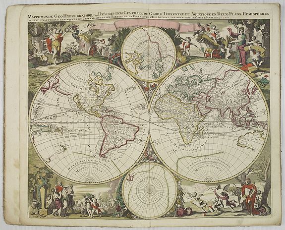
VALK, G. - Nova totius geographica telluris projectio. . . (Amsterdam, ca. 1711)
Size of the book block: 54.0 x 33.0 cm. / 21.3 x 13.0 inches. The maps are in attractive, strong, original colors.
Folio, in contemp. red half-sheepskin binding. Atlas comprises an allegorical title and 24 double-page maps in fine original coloring.
World map, Europe, the British Isles, Scandinavia (by Sanson), the Kingdom of Denmark, White Russia or Muscovy (by Sanson), the Kingdom of France (by Sanson), Teutschland (by Schenck), Rheni tractus, Princeps Danubius, Circuli Austriaci, Circulus Suevicus, the seventeen provinces of the Netherlands, Circulus Saxoniae Inferioris, Saxonia Circulus Superioris, Helvetiorum Reipublicae, Estates of Poland (by Sanson), Livoniae and Curlandiae, Totius Regni Hispaniae and Portugalliae (by Sanson), Italy (by Sanson), Empire of the Great Lord of the Turks (by Sanson), Asia, Africa, America.
All maps are signed Valk, with the exception of eight maps (seven from Sanson and one from Schenck).
Folio, in contemp. red half-sheepskin binding. Atlas comprises an allegorical title and 24 double-page maps in fine original coloring.
sold
This is the first atlas of Gerard Valk, publisher, engraver and manufacturer of globes in Amsterdam. The latter joined in 1673 Petrus Schenck for the publication of maps. In 1683, they acquired part of Joan Blaeu's stock and founded their own company in 1700. The association between the two families will continue until the middle of the 18th century.
We did not locate a copy of this atlas as of 1706. The copies cited by Koeman and Phillips are not dated. Koeman also specifies that, according to the copies, the number of maps can range from 25 to 100.
No example at the British Library.World map, Europe, the British Isles, Scandinavia (by Sanson), the Kingdom of Denmark, White Russia or Muscovy (by Sanson), the Kingdom of France (by Sanson), Teutschland (by Schenck), Rheni tractus, Princeps Danubius, Circuli Austriaci, Circulus Suevicus, the seventeen provinces of the Netherlands, Circulus Saxoniae Inferioris, Saxonia Circulus Superioris, Helvetiorum Reipublicae, Estates of Poland (by Sanson), Livoniae and Curlandiae, Totius Regni Hispaniae and Portugalliae (by Sanson), Italy (by Sanson), Empire of the Great Lord of the Turks (by Sanson), Asia, Africa, America.
All maps are signed Valk, with the exception of eight maps (seven from Sanson and one from Schenck).
