Captain's chart books
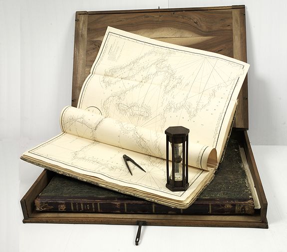
British Hydrographic Office / Dépôt Général de la Marine with maps made by Sir Edw. Belcher / Dalrymple. / J.Horsburgh/ R.H.Bate / G.H.Stapleton. The two chart books are bound in contemp. half calf, and includes 57 of the most up-to-date French (Depot général de la marine) and English (Hydrographic Office) charts available in 1847 for sailing to China.
Paris, London, Hong Kong, 1835 - 1849.
TOGETHER WITH: The chart books are still with their original wooden book-shaped captain's box for safekeeping of the charts. (The compass and hourglass are not included in the lot.)
Thirteen charts have in red pen and ink or lead pencil, the position of the ship at the end of each day.
The "Stella del Mare" was a Genova privateer and visited Hong Kong from 27th July until 6th October 1848.
Included are five charts made by Sir Edward Belcher of the Canton River and other charts of the Chinese coasts by the British Hydrographic Office from 1840.
Others by Dalrymple, Horsburgh and Robiquet. The British charts are early or first editions and are the earliest detailed charts of the Canton River and other coasts of China.
50,000 US$
BOOK 1 : Mostly charts by "Dépôt Général de la Marine", including 20 folding charts. The
binding measures 665x275mm, the charts mostly 595x910mm.
1. Dépôt Général de la Marine. Paris 1835. Carte hydrographique des parties connues de la Terre. World map in Mercator projection with the tracks of three in- and
outbound voyages are marked in manuscript, numbered 818.
2. Dépôt Général de la Marine. Paris 1838. Carte réduite des Meres du Nord depuis 48° jusqui'à 75° Latidude Septentrionale.Chart of Iceland, Greenland, England,
Norway, Denmark, Baffin Bay, Davis Street and Labrador. Numbered 871.
3. Dépôt Général de la Marine. Paris 1834. Carte de l'Océan Atlantique Septentrionale. Chart of the northern part of the Atlantic Ocean. In brown ink the track of
"Eridano" (October 1842- August 1845)
and in red the "Stella del Mare" (November 1847 - 1849). Numbered 800.
3a. ROBIQUET. Paris, 1846. Carte Générale de L'Océan Atlantique. Chart of the northern part of the Atlantic Ocean, With inset charts of Bermuda, St.Pierre, Bay of
St. Thomas. In lead pencil pinpoints and a track of the "Stella del Mare" (November 1847) from Cap de Gata (Spain) to Madera and the Canary Islands.
4. Dépôt général de la marine. Paris, 1832 (updated for 1837). Carte générale des sondes attérages des cotes occidentales de France et des cotes septentrionales
d'Espagne. Numbered 86.
5. Dépôt général de la marine. Paris, 1834. Chart of the southern part of the Atlantic Ocean. In brown ink the track of "Eridano" (October 1842- August 1845) and in
red the "Stella del Mare" (November 1847 - 1849)
(5a). Dépôt général de la marine. Chart of the southwestern part of the Atlantic Ocean. In red manuscript the track of the "Stella del Mare" (November 1847 -
1849)
(5b). Dépôt général de la marine.
(5c). 1845 Hydrographic Office. Island of Ascension. Surveyed by Lieut. G.A.Bedfort R.N. H.M.S.Raven 1838, R.H.Bate, London 1848. Numbered 1691.
(5d). Dépôt général de la marine. 1843 Chart of Patagonia, Terra del Fuego, including Shetland anf Falkland Islands. In ed ink the tracks of "Eridano" (January 1844
and Mars 1845) and the "Stella del Mare" (December 1847)
(5e). Hydrographic Office. R.H.Bate, London 1841. The south eastern part of Tierra del Fuego with Staten Islands, Cape Horn, and Diego Ramirez Islands surveyed by
Captain Robert Fitz Roy R.N. and the officers of H.S. Beagle 1830-1834 [...] With a few pin points in lead pencil for 1 January 1847 and 2 january 1848.
Interestingly the price for the chart has been updated in manuscript from four to five Shilling. Engraved by J. & C.Walker. Numbered 1873.
(5f). Dépôt Général de la Marine Paris 1837. 6 Charts on one sheet depicting places along Magellan Street : Plan du Port Famine et de la Baie Voces… Plan de la
Baie Saint Nicolas… Plan de la Baie Fortescue et du Port Gallant… Plan de la Baie Cordés et du Port San Miguel… Plan du Port des Trois Passes… Plan du Mouillag
extérieur du Havre Peckett. Numbered Pl.6 N°.1061.
(5g). Hydrographic Office. R.H.Bate, London 1840. Eastern entrance to Magellan Street by captain Robert Fitz Roy R.N. and the officers of H.S. Beagle 1834 [...]
Numbered 1316.
(5h). ROBIQUET, Paris 1847. Carte générale de la Mer Mediterranée ... Uncommon chart of the Mediterranean waters with ten inset maps (Malta, Livourne,
Bonifacio, Marseille, Gibraltar, etc) and in red pen and ink the in- and outbound track of the "Stella del Mare" (October 1847 - August 1849)
6. Dépôt Général de la Marine. Paris 1821.Carte réduite de la Mer Mériditerranée et de la Mer Noire..(First sheet) In brown ink the track of "Eridano" (September
1842- August 1845) visiting the harbours of Gibraltar and Cadiz. Numbered 203.
7. Dépôt Général de la Marine. Paris no date [1821]. (Second sheet of chart 6.) Showing the eastern part of the Mediterranean and Black Sea. Including Cyprus.
Numbered 204.
(7a). Dépôt Général de la Marine Paris 1827. Varter réduite de la partie septentrionale de L’Archipel. . . Numbered 281. Part of Greece with the Marmara Sea and in the upper right corner, Istanbul.
(7b). Dépôt Général de la Marine. Paris 1827. Carte réduite de la partie méridionale de l’archipel. . . Numbered 282. Chart of Greece with the island Crete in bottom.
8. Dépôt Général de la Marine. Paris 1836. Carte de la cote septentrionale d’Afrique (partie comprise entre Alger et les isles Zafarines). Numbered 841.
9. Dépôt Général de la Marine. Paris 1836. Carte de la cote septentrionale d’Afrique (partie comprise entre Alger et l’isle de la Galite.) Numbered 838.
BOOK 2 :
1./ FADEN,W. Sold by R.B.Bate London 1817?. A chart of the Indian Ocean Improved from the chart of M. D’Après de Manvillette with the addition of a part of the Pacific
Ocean as well as tracks of the principal discoverers, and other navigators to India and China. Chart of the Indian Ocean, with in lower right corner the Western half of
Australia. To the left the east coast of Africa, including Cape of Good Hope. The African continent is filled with two inset charts showing the North-East and South-west
monsoon. Numbered 748.
2./ Hydrographic Office, London 1 May 1813 [..] corrected to 1826. The Island of France or Mauritius from a French M.S. Prepared by captain Hurd R.N. Numbered
711.
3./ Hydrographic Office, captain Hurd R.N. [..] 11 January 1822. Chart of the Island of Ceylon with the adjacent coast of India by Captain Heywood R.N. and
M.Wedgeburgh. Large and extremely detailed map of Ceylon. Numbered 813.
4./ Dépôt Général de la Marine. Paris 1839. Carte du détroit de Banca (Malaisie). Levée et dressée par Mr. Vincendon-Dumoulin [..] a bord de la Corvette
l’Astrolabe… Numbered Pl.28 N° 1097.
5./ Depôt général de la marine. Paris, 1839. Routes des corvettes l’Astrolabe et la Zélée dans les détroits de Durion et de Sinchapour (Malaisie). Levée et dressée
par Mr. Vincendon-Daumoulin [..] à bord de la Corvette l’Astrolabe… With an inset chart of the track close to « Poulo Sinkep ». Numbered Pl.29 N° 1098.
6./ Dépôt Général de la Marine. Paris, 1846. Carte des détroits de Singapore, Durian et Rhio et des parages environnants ; Dressée d’après les cartes d’Horsburgh…
Very well executed engraving, with numerous insets of coastal profiles. Early edition of this important chart of the Singapore waters. Numbered 33.
7./ Dépôt Général de la Marine. Paris, 1839. Carte de la partie sud-est de la cote de l’isle Borneo. Levée et dressée par Mr. Vincendon-Dumoulin [..] a bord de la
Corvette l’Astrolabe… Numbered Pl. 32 N° 1085.
8./ Dépôt Général de la Marine. Paris, 1839. Routes des corvettes l’Astrolabe et la Zélée près des Isles Kagayan-Solo tracées par Mr. Vincendon-Dumoulin … Carte
d’une partie de la cote occidentale de Borneo… Carte d’une portion de la côte nord de Borneo et des Isles Balambangan et Banguey… (Three charts on one sheet.
Numbered Pl.30 N° 1099.
9./ Dépôt Général de la Marine. Paris, 1839. Carte de l’archipel Solo. Levée et dressée par Mr. Vincendon-Dumoulin [..] à bord de la Corvette l’Astrolabe… With inset
chart of « Plan de la Rade de Soog (Isle Solo). Numbered Pl.31 N° 1100.
10./ Dépôt Général de la Marine. Paris, 1839. Carte des isles situées entre Mindanao et Célébes. Levée et dressée par Mr. Vincendon-Dumoulin [..] a bord de la
Corvette l’Astrolabe… With inset chart of « Plan du mouillage de Ternate ». Numbered Pl.22 N° 1079.
11./ Dépôt Général de la Marine. Paris, 1839. Carte de la partie méridionale de l’isle Célèbes (Malaisie) Levée et dressée par Mr. Vincendon-Dumoulin [..] a bord de
la Corvette l’Astrolabe… With inset chart of « Plan de la Rade de Makassar and part of Isle Bouton and Ile Sud. Numbered Pl.27 N° 1084.
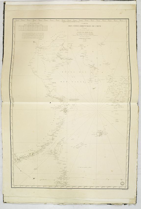
12./ Dépôt Général de la Marine. Paris, 1842. Carte des cotes orientales de Chine Dressée d’après les matériaux les plus récents publiée par ordre du Roi Sous le
Ministère de M. le Baron Duperré… In black ink and lead pencil the track of the "Stella del Mare" showing its navigation in the China Sea from June 12th 1848 till its arrival
in Macao on June 21st 1848. Detailed chart showing the China Sea, including China's coastline, Korea, Taiwan and Kiusiu. Numbered 957.
13./ Dépôt Général de la Marine. Paris, 1838. Carte de la Mer de Chine. Dressée Par M.Daussy […] d’après les travaux de Captaine Horsburgh […] publiée par ordre du
Roi Sous le Ministère de M.Ducampe de Rosamel…. In red ink the track of the "Stella del Mare" from its departure in Macao on 6 October March 1848 until its arrival on 12
October 1848 in Singapore. Numbered 865.
14./ HORSBURGH, James. Strait of Malacca Sheet 1st. London 1st January 1806 Additions to 1823. In red ink the track of the "Stella del Mare" from its departure from
Singapore on 19 October 1848 up to the 22nd of October navigating the waters of the Strait of Malacca.
On top of sheet, Horsburg gives credit to Capt. Charles Christopher Mc.Intosh and Commanders of ships trading from Bombay to China in testimony of the assistance
afforded by a liberal communication of their Journals and Remarks; this chart is inscribed by their most obliged. James Horsburgh.
15./ HORSBURGH, James. Strait of Malacca Sheet II. In red ink the track of the "Stella del Mare" from its departure in Singapore on 19 October 1848 navigating the
waters of the Strait of Malacca. Singapore Island is prominently shown.
16./ HORSBURGH, James. [Bay of Bengal] London 1st June 1825 corrected to 1844. In red ink the track of the "Stella del Mare" from its departure of Price of Wales Island
on first of January 1849 up to its arrival in Calcutta on January 14th. Its departure on March 18th and its navigations in the Bay of Bengal until April 6th 1849. On the upper
left Horsburgh is giving credit to Major James Rennell. The the left the east coast of India with Ceylon.
17./ STAPLETON,G.H. London 1847. The River Hoogly from Calcutta to Cowkolly light-house. Drawn on tranfer paper by G.H.Stapleton & printed at the Gov.t lith : press
1847.
18./ Dépôt Général de la Marine. Paris, 1837. Carte générale de la Mer des Indes. Dressée Par M.Daussy […] et P.E.Wissocq […] publiée par ordre du Roi Sous le
Ministère de M.Ducampe de Rosamel. In red ink the track of the "Stella del Mare" from its departure in Calcutta on 19 March 1949 untill its arrival on 25 May 1849 in Table
Bay in South Africa. Numbered 863.
19./ Hydrographic Office. R.H.Bate, London March 27th 1840. Index to the chart of the coast of China. Detailed chart of the coast of China till the island of Hainan, including Formosa, west coast of Korea and Luzon. Numbered 1262.
20./ Hydrographic Office. R.H.Bate, London May 20th 1840. The China Sea. Accompanying chart of the southern part of the China Sea, with Hainan Island, Cochinchina, Malaysia, Borneo and the west coast of the Philippinnes. Numbered 1270.
21./ Hydrographic Office. R.H.Bate, London May 20th 1840. China Sheet I South coast from Hainan Is. to Macao. Numbered 1246.
22./ Hydrographic Office. R.H.Bate, London January 27th 1840. China Sheet II from Macao to Namoa. Hong Kong is named. With lead pencil pin points showing its positions after its departure from Hong Kong on 27th July till 1 August 1848. With some additional pin points in the China sea. Numbered 1247.
23./ Hydrographic Office. R.H.Bate, London January 27th 1840. China Sheet III East coast of Namoa to Haïtan island. Numbered 1243. Including the east coast of Taiwan. Numbered 1243.
Hydrographic Office. R.H.Bate, London, June 18 1841 with corrections in January 1843. China Sheet V East coast from the Kwesan Islands to Whang-Hu Gulf the Yang-Tse Kiang by Capt. R.D.Bethuner R.N. Chusan & by lieut.t Collinson R.N. 1840. Numbered 1257.
24./ Hydrographic Office. R.H.Bate, London January 27th 1840. China - Sheet VII East coast Yellow Sea and Gulf of Pechili additions and corrections to 1841. With inset chart of “Canal communication from Pekin to the Gulf of Pe-Chili.” Numbered 1256.
25./ Hydrographic Office. R.H.Bate, London January 14th 1847. China - Chou-Kiang or Canton River Sheet I from Lantao I.d. to Lanket Island serveyed by captain Sir Edw.d Belcher C.B. and Captain Daniel Ross Bombay Marine 1815. Numbered 1782.
26./ Hydrographic Office. R.H.Bate, London January 22nd 1846. China - Chou-Kiang or Canton River Sheet II from Lintin Bar to Tiger Island surveyed by captain Sir Edw.d Belcher C.B. 1840. Numbered 1741.
27./ Hydrographic Office. R.H.Bate, London January 19th 1846. China - Chou-Kiang or Canton River Sheet III from Tiger Island to second bar Pagoda surveyed by captain Sir Edw.d Belcher C.B. 1840. Numbered 1740.
28./ Hydrographic Office. R.H.Bate, London January 22nd 1846. China - Chou-Kiang or Canton River Sheet IV from the second bar Pagoda to Whampoa and Chang- Shan Island surveyed by captain Sir Edw.d Belcher C.B. 1840. Numbered 1742.
29./ Hydrographic Office. R.H.Bate, London January 22nd 1846. China - Chou-Kiang or Canton River Sheet V from Whampoa Channel and Changshan Island to Canton surveyed by captain Sir Edw.d Belcher C.B. 1840. Numbered 1739.
Hydrographic Office. R.H.Bate, London May 4th 1844. China - The river Min from the entrance to the pagoda anchorage surveyed by captain N. Kellett R.N.C.B. Numbered 1593.
30./ Hydrographic Office. R.H.Bate, London July 7th 1843. China - The Yang-Tse Kiang from the sea to Nanking surveyed by Capt. C.R.D.Bethune H.Kellet & R.Collinson 1842. Numbered 1480.
31./ Hydrographic Office. R.H.Bate, London April 6th 1838. China - Toong-Koo or Umstone Bay by James Sprent master of H.M.S. Wellesley 1838. Numbered 1222.
32./ Hydrographic Office. R.H.Bate, London January 18th 1841. China - Strait Islands of Mia-Tao by W.Dillon second master of the H.M.S. Wellesley 1840. Numbered 1392.
33./ Hydrographic Office. Dalrymple, London February 17th, 1792. Chart of the south west part of Japan from a Dutch M.S. Numbered 1034. Showing the Bay of Nagasaki.
34./ Hydrographic Office. R.H.Bate, London January 27th 1840 corrected to June 1841. The peninsula of Korea. Numbered 1258. . (62290)