Mappa Geographica novissima Regni Hungariae
Müller Ignácz ( Müller Ignác): Mappa Geographica novissima Regni Hungariae divisi in suos Comitatus cum Districtibus Jazygum et Cumanorum, Banatus Temesiensis ejusque Districtuum nec non Regnorum Croatiae, Slavoniae, Dalmatiae, Magni Principatus Transsylvaniae, partis Bosniae, Serviae, Bulgariae et Walachiae. Dedicata Augustissimis regnantibus Mariae Theresiae Imperatrici Reginae et Josepho II Romanorum Imperatori et Corregenti. Promotore Excellentissimo Domino Generali Campi Mareschallo et Consilii Aulae Bellici Praeside Comite Mauritio a Lacy. Ex Accuratoribus Tabulis congesta et correcta Anno 1769. Ab Ign[atio] Müller S.C.M. Sup. Vigil. Magistro. Johan Christoph Winkler sculpsit. - Vienna. 1769.
Translated into English, "The latest geographical map of the Kingdom of Hungary...", followed by a summary of the content: it depicts the territory of the country divided into counties, the Jasz and Kun districts, the Temes banate, as well as the Croatian, Slavonian and Dalmatian Kingdoms and the Principality of Transylvania. The title states that the map was compiled and corrected from the most exact surveys available, completed in 1769, and edited by Ignác Müller, described in his own imperial commission as Quartermaster-General to His Imperial Majesty. The caption states that, at the time the map was made, these territories were governed by Empress Maria Theresa, Queen of Hungary, and Holy Roman Emperor Joseph II, and that the work was supervised by Count Moritz Lacy, Chief of Staff and Marshal of the War Council.
The map also shows the bordering regions of neighboring countries (then still under Turkish occupation), such as Bosnia, Bulgaria, Serbia and parts of Havaselve (Walachia).
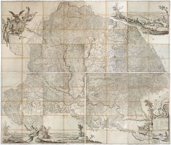
The map was engraved by Johann Christoph Winkler, a renowned Viennese engraver. The printed copies were treated confidentially, and the number of copies published is unknown. The map was printed on 12 different-sized sections that combine to form a map with an internal size of 241.0 x 203.5 cm. The largest section measures 98 x 68 cm, which is a great rarity, and its paper was made in Volkersthausen on the shores of Lake Constance for this purpose. This example was contemporaneously intersected and pasted on linen on 4 sheets. If joined, the total size is 204 x 244 cm.
Copper engraving. Contemporarily intersected and laid on canvas. The map was printed on 12 sheets. The example, contemporarily intersected and pasted on linen, on 4 sheets. If joined, the total size is: 204x244 cm.
The title states that the map was compiled and corrected from the most exact surveys available, completed in 1769, and edited by Ignác Müller, described in his own imperial commission as Quartermaster-General to His Imperial Majesty. The plates were engraved by the well-known Viennese copper engraver Johann Christoph Winkler, and according to one period reference, an early issue of the sheets the "Mappa Geographica novissima Regni Hungariae" of 1769 occupies a pivotal place between two eras of Hungarian cartography: it closed out more than half a century of piecemeal county- and district-level survey work initiated under Sámuel Mikoviny, and it stood, for roughly two decades, as the most authoritative general map of the kingdom available to the Habsburg administration, before being superseded by the first systematic triangulated survey of the Josephine era.
The baroque beauty of its drawing, form, and graphic decorative elements also makes it stand out from similar works of the time. Its combination of technical advance, restricted circulation, and imposing physical scale — forming a wall map over two meters across — makes surviving complete examples significant survivals of eighteenth-century Central European state cartography.
POR / Inquire
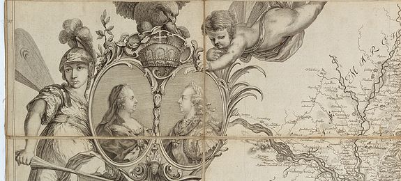
The complete map divides the territory of the kingdom into its counties, the Jász and Kun districts, and the Banat of Temesvár, and further depicts the Kingdoms of Croatia, Slavonia, and Dalmatia and the Principality of Transylvania, together with adjoining, then Ottoman-controlled, portions of Bosnia, Bulgaria, Serbia, and Wallachia. The engraved dedication names Empress Maria Theresa and her co-regent, the Holy Roman Emperor Joseph II, as the reigning sovereigns at the time of production, and records that the undertaking was supervised by Field Marshal Count Franz Moritz von Lacy, president of the Aulic War Council (Hofkriegsrat).
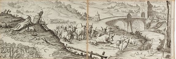
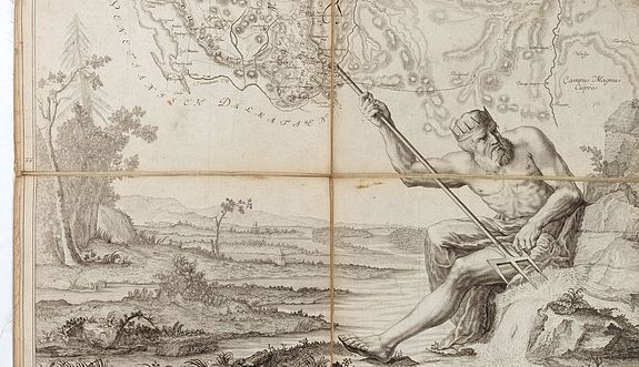
A striking, though considerably idealized, landscape vignette adorns the upper right sheet. Sources differ on the map's scale, most likely because more than one derivative edition circulated: the original twelve-sheet Vienna plate is recorded at a scale of roughly 1:315,000 (six German miles equalling 12.5 cm), while a later, reduced four-sheet edition bearing the German-language sub-title "Königreich Ungarn samt den angränzenden Ländern" — attributed on its surviving copies to Anton von Wenzely — is recorded at a considerably smaller scale of approximately 1:1,200,000, with legends and administrative-division tables added in German.
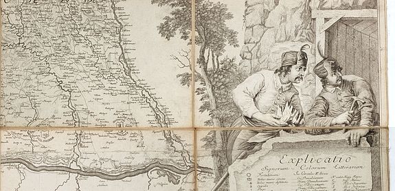
That derivative issue is described as "Ex accuratoribus Tabulis congesta et corecta," on four sheets, copperplate engraving with hand coloring, an index of administrative divisions ("Divisio Totius Regni in Ciculos et Comitatis"), and a title given in both Latin and German.
Historical Background and the Genesis of the Commission
Before Müller's map, the last cartographic survey of the entire kingdom of comparable ambition had been undertaken more than two centuries earlier. The Tabula Hungariae, the earliest surviving printed map of the Kingdom of Hungary, is traditionally credited to the Hungarian cleric Lázár deák and was produced before 1528; it was inscribed on UNESCO's Memory of the World Register in 2007.
In the intervening two hundred years, no state-sponsored general map of Hungary of similar authority had been completed. The immediate eighteenth-century predecessor to Müller's map was the 1709 wall map compiled by the surveyor-engineer Johann Christoph Müller — no direct relation to Ignác Müller, though the shared surname has occasionally caused confusion in the antiquarian trade.
Johann Christoph Müller had been commissioned in 1706 to produce a large-scale general map of Hungary based on his own field surveys rather than on compiled secondary sources, a highly regarded innovation at the time; the resulting four-sheet wall map, engraved by Johann Andreas Pfeffel and Christian Engelbrecht and later reissued in reduced form by the Homann firm of Nuremberg, covered the territories of present-day Austria, Hungary, Slovakia, Slovenia, Croatia, Bosnia-Herzegovina, Serbia, Bulgaria, Romania, and Ukraine.
By the middle of the eighteenth century, however, this map's known deficiencies — inevitable given the scale of the survey task and the passage of six decades — no longer met the operational requirements of the Hofkriegsrat, the Austrian crown's central military administration.
A new survey was accordingly ordered in 1764. Considerable groundwork for the project already existed: the military engineer and surveyor Sámuel Mikoviny had, before his death in 1750, produced a series of county maps covering more than fifty Hungarian counties, along with regional overview maps of several parts of the kingdom, and further cartographic material had been assembled at the direction of Field Marshal Count András Hadik, then president of the Hofkriegsrat.
What this material still required was a single cartographic officer — one familiar with the languages of the kingdom's population and capable of organizing, verifying, surveying in the field where necessary, and drafting a unified compilation — to bring it together into one coherent, authoritative map. Mikoviny's county survey had itself been incomplete at his death: the counties of Zala, Heves, Hajdú, Szabolcs, Szatmár, and Szilágy, together with the seventeen counties of Transylvania, were missing and had to be reconstructed from smaller-scale regional maps, very likely supplemented by fresh fieldwork.
As a precedent, the results of the work of Sámuel Mikoviny: the series of maps made of more than 50 counties, overview maps of certain parts of the country, and the map material collected by order of the legendary Field Marshal András Hadik, the president of the Court War Council, awaited the organizing, systematizing, surveying, and cartographic activities of a suitably prepared cartographer who also knew the language of the country's population. The result of this was ultimately the creation that we know as the Müller map.
According to László Bendefy ( Geodézia és Kartográfia, 26.évf. 1974., p. 122-132. ): After the Lázár map ( "Tabula Hungariae...", 1528 ) was made during the Dózsa Peasants' War ( 1514 ), there was no mapping of national importance in our country for almost two centuries. The map made by Johann Christoph Müller in 1709, the map of Hungary, due to its shortcomings, no longer met the needs of the Court War Council (Hofkriegsrat) from the mid-18th century. Therefore, a new map was ordered in 1764.
In 1764, an independent mapping group was assigned to his command, and then he was assigned to the cartographic department under the direction of Field Marshal Franz Moritz Lacy. Here, he was tasked by the Court War Council on May 13, 1764, with preparing a new map of Hungary. Using the available material (primarily Mikoviny's county maps and the collected county maps), his group of cartographers prepared the overview map of our country in four and a half years. We can judge the extent of the work done by noting that, at the time of Mikoviny's death in 1750, the series of county maps he had compiled was incomplete. The map of Zala, Heves, Hajdú, Szabolcs, Szatmár and Szilágy counties, as well as the 17 Transylvanian counties, was missing.
The gaps had to be compiled from the country maps, but it can be assumed that significant fieldwork and site surveying were also necessary. On June 26, 1769, Colonel Ignác Müller reported to Sergeant Major Lacy that - as can be verified by the frequently performed control measurements in the meantime - a map of Hungary had been created that surpassed all previous ones in terms of the number of data, the spatial accuracy of the indicated locations and the writing of place names. The Court War Council awarded Ignác Müller an unprecedented amount of reward for his cartographic engineering activities.
Ignác Müller Ignác Müller
was born in Székesfehérvár in 1727. He entered military service at the age of seventeen and rose quickly through the ranks. In 1764, he was given command of his own survey group and was then attached to the cartographic department operating under Field Marshal Franz Moritz von Lacy. In this post, the Hofkriegsrat formally charged him on 13 May 1764 with compiling a new map of the Kingdom of Hungary. Working from the material already assembled — chiefly Mikoviny's county surveys together with the collected regional maps.
Müller's cartographic team spent four and a half years compiling the general overview map of the kingdom.
The scale of the undertaking can be gauged from the gap Müller's team had to close: an entire tier of county maps, plus the whole of the Transylvanian survey, existed only in fragmentary or indirect form and had to be reconciled and, where necessary, resurveyed. On 26 June 1769, by then holding the rank of colonel, Müller was able to report to Marshal Lacy that — as repeated control measurements over the intervening years had confirmed — the resulting map surpassed every earlier production in the number of data points recorded, in the spatial accuracy of the settlements shown, and in the reliability of its place-name orthography. In recognition, the Hofkriegsrat awarded Müller a sum for his cartographic-engineering work that was, for the time, without precedent.
After completing the Hungary map, Müller was posted in 1771 to Nagyenyed (present-day Aiud, Transylvania). Three years later he requested retirement, after which he settled in Pozsony (present-day Bratislava), where he died in 1804. His name survives principally through this single, outsized cartographic achievement.
Production, Secrecy, and Survival
Because the map originated as a strategic instrument of the Hofkriegsrat rather than a commercial publication, the printed sheets were treated as sensitive material, and the number of copies struck is not known with certainty; surviving evidence points to a small, controlled print run intended primarily for military and administrative use rather than for the open map trade. This confidentiality helps explain the map's rarity today.
Complete assembled examples are held in Hungary at the National Széchényi Library (Országos Széchényi Könyvtár) and in the map collection of the Military History Museum and Archive (Hadtörténeti Múzeum és Levéltár).
Individual engraved sheets or complete sets also survive outside Hungary, including a set digitized by the Bibliothèque nationale de France (Gallica), a set in the collections of the University of Wisconsin–Milwaukee, and scanned sheets hosted on Wikimedia Commons; a reduced four-sheet derivative edition is preserved in at least one Polish institutional collection accessible via the Internet Archive.
Cartographic and Documentary Significance:
Within the historiography of Hungarian cartography, Müller's map is generally regarded as the most accurate general survey of the kingdom to appear before the Josephinische Landesaufnahme (the Josephine land survey) of the following decades. Its value lies in several dimensions at once: as a synthesis of the mid-century county-level surveying work begun by Mikoviny; as a record of the administrative geography of the Hungarian crown lands — counties, the Jász-Kun districts, the Banat of Temesvár, and the associated kingdoms and principality — on the eve of major later administrative reorganizations; and as a visually accomplished production of late-Baroque decorative map-making, distinguished, in the words of Hungarian bibliographic tradition, by drawing, layout, and ornamental engraving that set it apart from comparable maps of its period.
Its coordinate accuracy substantially exceeded that of every earlier comparable production, and its toponymy was markedly more detailed, qualities that, together with the Baroque elegance of its draughtsmanship, layout, and ornamental engraving, set it apart from other maps of its era.
Because the map also depicted the still Ottoman-influenced borderlands to the south and east — Bosnia, Serbia, Bulgaria, and Wallachia — it carried clear strategic value for the Hofkriegsrat beyond its administrative utility within the Hungarian lands proper, which is consistent with the guarded manner in which the printed sheets were distributed.
References
- Bendefy, László. "A Müller-féle Magyarország-térkép keletkezésének körülményei." *Geodézia és Kartográfia*, vol. 26 (1974), pp. 122–132.
- Magyar bibliofília, entry "Müller Ignácz (Müller Ignác): Mappa Geographica novissima Regni Hungariae divisi..." (magyarbibliofilia.hu), citing Szántai/Müller I. 1a.
- Bibliothèque nationale de France, Gallica, catalogue record, *Mappa Geographica novissima Regni Hungariae...* (ark:/12148/btv1b531700710).
- Wikimedia Commons, Category: Mappa geographica novissima Regni Hungariae (digitized sheets after the Gallica/BnF exemplar).
- Domanovszky, Sándor (ed.), *Magyar művelődéstörténet*, vol. 4, "Barokk és felvilágosodás," chapter by Tibor Mendöl, "Az új települési rend" (Arcanum digital edition).
- University of Wisconsin–Milwaukee Libraries, American Geographical Society Digital Map Collection, record for the Müller map.
- Internet Archive / rcin.org.pl, record for the reduced four-sheet derivative, "Koenigreich Ungarn samt den angränzenden Ländern" (attributed to Anton von Wenzely on that issue).
