Novae Archiepiscopatus Moguntini Tabulae (or "Mainzer Atlas")
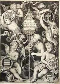
The Atlas of the Electorate and Diocese of Mainz (Mayence)—the magnum opus of the architect Nikolaus Person—is the first and one of the finest German regional atlases. It depicts the holdings of the Archbishop of Mainz along the Rhine and in Hesse and Thuringia in western and central Germany. All are double-page specialized maps featuring elaborate cartouches. It includes a beautifully engraved allegorical title page.
POR
1. Electorate of Mainz (overview map); 2. Eichsfeld; 3. Erfurt region; 4. Amt Fritzlar; 5. Amt Naumburg; 6. Katzenberg Court; 7. Amt Neustadt; 8. Amt Amöneburg; 9. Spessart; 10. Amt Bischofsheim and Krautheim; 11. Amt Amorbach; 12. Allnfeld and Neydenau (Neckar/Jagst); 13. Odenwald/Dieburg; 14. Taunus; 15. Odenwald/Bensheim; 16. Lower Rhine (Hunsrück/Nahe); 17. Untitled (Koblenz/Boppard/Moselle).
The Elector-Archbishop of Mainz, Anselm Franz von Ingelheim, commissioned the maps. The atlas is a regional atlas covering the Electorate/Archbishopric of Mainz and adjacent territories (Hesse, Isenburg, Hanau, the Rhine's upper regions, etc.). Including an engraved title, allegorical frontispiece and 17 double-page maps, each roughly 54×40 cm Folio. Modern calf binding; all maps on strong paper with full margins.
A very rare regional atlas. * The "Mainz Atlas" is the major work of the architect and engraver Nicolas Person (c. 1660–1710), who also published several collections of engraved portraits and plans of fortifications. This atlas was produced at the behest of the Elector of Mainz, Archbishop Anselm von Ingelheim (reigned 1679–1695).
It aimed to map the widely scattered territories of the Electorate of Mainz, situated between Thuringia, Hesse, and the Rhineland. The maps vary in scale (between 1:16,000 and 1:50,000) and feature numerous topographical symbols indicating castles, churches, ironworks, brickyards, glassworks, etc.
The elaborate ornamentation of the decorative cartouches reflects each region's specific characteristics. Contents include an engraved title page (depicting a globe and a female allegorical figure representing the art of surveying), a contemporary manuscript title page ("Archiepiscopatus Moguntini typus. 1685"), and 17 regional maps.
This significant atlas—the only specialized atlas of the Archbishopric and Electorate of Mainz (completed around 1685)—was the first, and one of the finest, German regional atlases of the 17th century. Early edition, identifiable by the mirror-image printing of the name "Ottenwaldt" in the right margin of the 13th map ("Locorum Moeno Mogono pars media"), an error corrected in later editions.
The final map lacks an inscription in its designated cartouche; later editions replaced it with a large general overview map. As the Electorate of Mainz was distributed across vast areas of central and southwestern Germany—spanning the regions between the Main and Moselle rivers and the territories of Hesse and Thuringia—the regional maps logically depict these individual territories as specialized maps (each featuring a decorative cartouche and mileage scales): Amorbach, (Tauber-)Bischofsheim, the Erfurt region, Eichsfeld, Katzenberg, Naumburg/Hesse, Neustadt, Odenwald, Spessart, etc.
References :
Häuser, Helmut: "Zum kartographischen Werk des Mainzer Kupferstechers und Ingenieurs Nikolaus Person" [On the Cartographic Work of the Mainz Engraver and Engineer Nikolaus Person], in: *Festschrift für Josef Benzing*, Wiesbaden 1964, pp. 170–186 (includes a biography and detailed description of this rare regional atlas); and by the same author: "Der Mainzer Atlas von Nikolaus Person" [The Mainz Atlas by Nikolaus Person], in: *Lebendiges Rheinland-Pfalz* 13/1976, pp. 21–25.
