de l'Isle composite atlas
This composite atlas is highly significant, as it includes three of de L'Isle's earliest maps of North America, each of which serves as a cornerstone in the continent's cartographic history.
Including maps of the Americas: Western Hemisphere, Canada, Map of Louisiana, Mexico, the West Indies (Carte de l'Isle de Saint Dominique and Carte des Antilles françoises et des isles voisines), Peru, Brasil, Paraguay and Magellan.
It also extends to other regions, including Asia (Muscovy, Turkey, Arabia, Persia, India, China, Ceylon, Tartary) and Africa (Egypt, Barbary, Guinea, Congo, Abyssinia). Supplemented by a few maps from ancient geography and the Middle Ages.
The atlas includes an engraved list of maps with publication dates for each, some of which have been updated by hand, an engraved title page (for an atlas by Jaillot), and four tables bound at the end. Maps numbered and titled by hand on the reverse.
Contemporary marbled sheepskin, ribbed spine, richly decorated panels, gilt fillet on the edges. Some maps are slightly browned, creased, or restored.
The atlas is in fine original coloring. Most maps are colored in the style of the early 18th century, with outline-line coloring. The map of Louisiana/Texas, among others, has the sea in body color.
Three of the four maps of America are cornerstone maps for North American mapping:
- Carte du Canada ou de la Nouvelle France et des Decouverts qui y ont été faites... (1703) - The map of Canada in a first edition.
- Carte du Mexique et de la Floride des Terres Angloises et des Isles Antilles : du cours et des environs de la Riviere de Mississipi [sic], dressée sur ungrand nombre de memoires principalemt. sur ceux de M.rs d'Iberville et le Sueur. (1703) - The map of Mexico, in a first edition, third state.
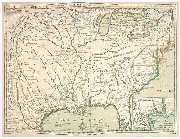
- Carte de la Louisiane et du cours du Mississipi.. - The Map of Louisiana and the Course of the Mississippi, the first printed map to locate “Texas,” - The map marks a turning point in the cartographic history of the region. “The most important reference for the history of Texas... is the one that appears along the Trinity: Mission de los Tiejas, established in 1716. This phrase marked the first appearance of a form of the name Texas on a printed map, and thus Delisle received due credit for establishing Texas as a geographical place name” (Martin & Martin).
P.O.R.
The De l'isle atlases usually do not have a title page. Our atlas has a bound-in title page from A.H. JAILLOT, - "Atlas françois contenant les cartes géographiques dans lesquelles sont très exactement remarquez les empires, monarchies, royaumes et états de l'Europe, de l'Asie, de l'Afrique et de l'Amérique...", Paris: Sr. Jaillot, 1725.
Interestingly, Jaillot's name is removed, and the name of de l'Isle and the date 1725 are added in brown ink in manuscript. The date in the lower line has a paston strip of white paper.
The first edition of the Map of Louisiana and the Course of the Mississippi, the first printed map to locate “Texas”
CARTE DE LA LOUISIANE ET DU COURS DU MISSISSIPI Dressée su un grand nombre de Memoires entrau tres sur ceux de Mr. le Maire. Paris: Chez l’Auteur le Sr. Delisle sur le Quay de l’Horloge, June 1718.
This map by Delisle is considered one of the most important maps of North America, serving as the primary source for the later maps of the Mississippi published by Homann, Moll, Senex, and Seutter.
“This map is the origin of all subsequent maps of the Mississippi.”
(J. G. Kohl); “One of the most important reference maps of the North American continent,” (William P. Cumming).
By 1700, the English, French, Spanish, and indigenous peoples of North America were locked in a four-way cage fight for control of the continent and its resources. The French had established firm control of the St. Lawrence and the Colony of New France, developed strong relations with many Native American peoples, and traversed and established posts along the Great Lakes and the Mississippi River to the Gulf of Mexico. In 1699, Louis XIV gave his support to Pierre le Moyne, Sieur d’Iberville’s proposal for colonizing Louisiana, and the first forts were built almost immediately at Biloxi and Mobile Bays. Given their extensive firsthand experience and numerous Native American sources, the French were best positioned for preeminence in mapping North America.
The map is also important for recording the current state of the Louisiana Colony, which is highlighted by an inset of the Gulf Coast from the Mississippi Delta to Pensacola. The map shows numerous French forts and trading posts, both active and abandoned, along the Gulf Coast, lower Mississippi and Red River. Among these are Natchitoches, established by Louis Juchereau de St. Denis in 1714 and the oldest permanent European settlement in the region of the future Louisiana Purchase. St. Denis’ epic 1713 (i.e., 1714) and 1716 explorations/trading missions to the Spanish on the Rio Grande are also delineated.
Events of the more distant past are also shown, including La Salle’s short-lived Fort Francois at Matagorda Bay, as well as an interpretation of the route of De Soto’s 1539-1543 expedition, which “parallels in general the findings of the exhaustive Final report of the United States de Soto expedition commission (1939).” (Cumming et al, p. 156)
References: Cohen, Mapping the West, pp. 50-51 (illus.) Cumming and de Vorsey, Southeast in Early Maps, Third Edition, #212, pl. 47. Cumming et al, The Exploration of North America 1630-1776, p. 156. Lemmon, Magill and Wiese, eds., Charting of Louisiana, #18 (p. 58) Martin & Martin, Maps of Texas and the Southwest 1513-1900, pl. 19, pp .98-99. Phillips, Maps of America, p. 367. David Rumsey Map Collection, #4764.098. Tooley, “French Mapping of the Americas,” #43 (in The Mapping of North America). Wheat, Mapping the Transmississippi West, vol. I #99.
In 2026, on February 26th, it will be 300 years since Guillaume de L'Isle died at the age of 50.
Guillaume De L'Isle was one of the most important cartographers in France in the early 18th century.
Guillaume de l’Isle (1675-1726), son of a geographer (Claude de l’Isle) and brother of another (Joseph), and a student of astronomer Jean-Dominique Cassini, Guillame had brilliant connections in French cartographic circles.
DeLisle is important as the first "scientific" cartographer to incorporate the latest information on exploration and topography into his maps. His maps of America contain many innovations: discarding the fallacy of California as an island, the first naming of Texas, the first correct delineation of the Mississippi Valley, and the first correct longitudes of America. Lloyd Brown states that DeLisle "undertook a complete reform of a system of geography that had been in force since the second century, and by the time he was twenty-five, he had very nearly accomplished his purpose."
His first maps of North America were L’Amerique Septentrionale (1700), Carte du Mexique et de la Floride des Terres Angloises et des Isles Antilles (1703), and Carte du Canada (1703). Together, these provided the most coherent picture of the continent to date, particularly the great chain of waterways from the Gulf of St. Lawrence, down the St. Lawrence River, through the Great Lakes, and down the Ohio, Wabash, and Mississippi to the Gulf of Mexico. The Carte de la Louisiane et du Cours du Mississipi. Fifteen years later, de l’Isle issued his cornerstone map of North America, offered here in the first state (the second state, issued soon thereafter, adds New Orleans, founded in 1718).
His different addresses.
Guillaume De L’Isle’s first printing shop was established on the "Rue des Canettes pres de St. Sulpice" in Paris. This address appears only on editions of maps dated 1700-1707.
- Most examples of his work were issued from the address where De L’Isle moved in 1707, the "Quai de L’Horloge".
- A map of Piedmont dated 1707 informs us that by that date De L'Isle had moved to the "Quai de l'Horloge à la Couronne de Diamans". The latest date on a map found bearing this address is January 1708. However, this atlas contains several maps predating 1707.
- It is accepted that in early 1708, De L'Isle changed the sign over the shop to "à l'Aigle d'Or", the golden eagle.
- "Le Cours du Rhin au-dessus de Strassbourg", has the following address "À Paris chez l’Auteur sur le Quai de l’Horloge à l’Aigle d’Or, avec privilège, 1704.
- It is accepted that De L'Isle, in 1718, added his newly received title "Premier Geographe du Roy" to his address. However, a recently discovered map, Carte particuliere de la Hongrie ... Sclavonie, carries the date 1717.
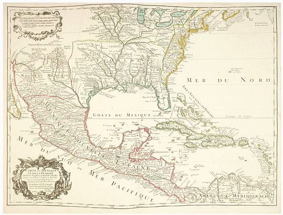
This map by Guillaume de L'Isle was engraved by C. Simonneau in 1703. The map covers North America, focusing on present-day Mexico, the southeastern United States, and the Caribbean islands. It includes notable regions such as Mexico, Florida, and the Mississippi River and its surrounding areas. The map features detailed representations of rivers, place names, and the extensive coastlines of the Gulf of Mexico and the Caribbean. The ornamental title cartouche in the bottom left corner, which is intricately designed with floral and possibly allegorical elements, a typical feature of maps from this period.
Significant landmarks include the Mississippi River, which is central to the map, emphasizing its importance in the region's exploration and settlement. The map also details the territories of New Spain, the French claims in North America, and British territories along the eastern seaboard.
Inscriptions on the map are primarily in French, reflecting the language of cartography and scholarship in Europe during the 18th century. The map reflects the geopolitical context of the time, with European powers delineating their claims and interests in the New World.
First edition, third state; The first edition bears De L'Isle's first address on Rue Des Canettes, which was later changed to Quai de l'Horloge Couronne de Diamans and the imprint of Renard in the second state. In the third state, the Couronne de Diamans and Renard imprint are removed and the engraver's name Simoneau appears.
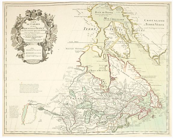
Canada - Carte du Canada ou de la Nouvelle France et des Decouverts qui y ont été faites...
This is Guillaume de l'Isle's groundbreaking map of Canada - one of the most important maps of the northern parts of North America. When De l'Isle first issued this map in 1703, it was the most sophisticated cartographic representation of this region yet published, drawing on elements from the most recent explorations, including the Jesuit Relations, Pierre Le Moyne d'Iberville, Pierre Le Moyne d'Iberville, and Baron de Lahontan. This map proved highly influential and was one of the best maps of this region until the explorations of the late 18th and early 19th century.
According to Kenneth Andrew Kershaw, this is: "One of the most outstanding maps of Canada of the 17th and early 18th centuries . . . De l'Isle's careful research resulted in the first map of Canada to present the whole of the Great Lakes correctly. In addition, the position of the lakes relative to Hudson's Bay is also correct, and the Avalon Peninsula is shown much more realistically than on previous maps of Canada. Of considerable significance, the geography of the coastal regions of James and Hudson Bays, together with their major rivers systems, is presented by De l'Isle with a surprising degree of accuracy.
De L'Isle's map shows the speculative explorations of the Baron Louis Armand de Lahontan, which dominate the lower left. Lahontan (1666 - 1715) was a French military officer commanding the fort of St. Joseph, near modern-day Port Huron, Michigan. Abandoning his post to live and travel with local Chippewa tribes, Lahontan claims to have explored much of the Upper Mississippi Valley and discovered a heretofore unknown river, which he dubbed the 'Longue River'.
De l'Isle himself was skeptical, qualifying the description with the caveat, 'unless Mr. Lahontan has invented all of these things, which is difficult to resolve, he being the only one to penetrate this vast country.'
The beautiful engraving of the cartouche was the work of Nicholas Guérard. it is flanked with images of Native Americans - one woman with a papoose on her back, and a fierce warrior displaying a scalp. In a nod to the predominance of Jesuit sources for French geography in the region, the cartouche also includes vignettes of missionaries preaching to the Natives. The cartouche also features Canadian fauna, including an alarming beaver, while a goose lurks in the shadows.
The De L'Isle map of Canada appears in nine different states, and in addition, several close derivatives. RARE : Here in a fourth state with the address "Chez l'Auteur sur le Quai de l'Horlage a la Aigle d Or... 1703".
Reference: Kershaw, Entry 311. Plate 202D
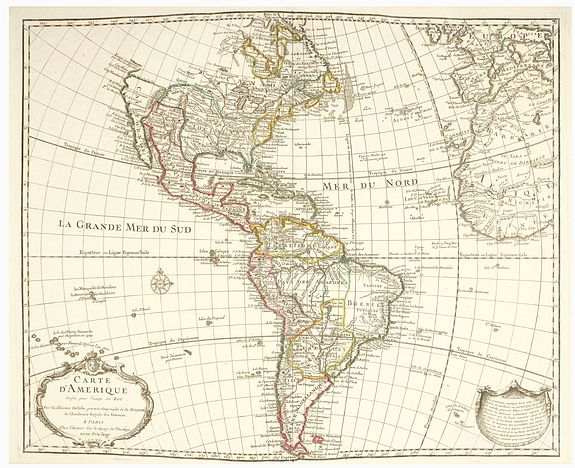
Maps of America contain many innovations: discarding the fallacy of California as an island.
Second state De l'Isle's important and highly influential map of North and South America, with the plain lettering of the word "d'Amerique" in the title. For California, the west coast is taken north to Cap Mendocin and Cap Blanc, with the notation, "Entrée decouverte par Martin d'Aguilar." Wagner notes, "Briggs names with some of the corrections made by Blaeu. The Mediterranean Sea of California has disappeared. Delisle retained Cabrillo's B. de Pinos and introduced a few, the I. Ste Anne, the B. de St. Martin, and the B. de la Medelaine, from other maps. It seems likely that he had read the account of the Vizcaino expedition Torquemada... On the Sonora coast, the names are much the same as those on his 1700 map, with a few additions from Kino's map and other sources in Sonora..."
Like many of De l'Isle's maps, this one had a long life, as Tooley notes, "His map of America of 1722 was republished until 1830, revised in places but basically unchanged..."
References : Portinaro & Knirsh Plate 114; Tooley p.13, #1, & Plate 1 state); Wagner NW Coast 523. Item #16-3573
Mappe-Monde Drésse sur les Observations de Mrs. de l'Academie Royal des Sciences et quelques autres sur les memoires les plus recens.
Another essential map is his world map and proved to be one of the most influential world maps of its time, and is present here with the address "Sur le Quay de l'Horloge", dated 15 Avril, 1700.
In this map of the world, De l'Isle was among the first cartographers to re-establish California's proper form as a peninsula, to give more or less accurate configurations to all five Great Lakes, and to show the full extent of the Mississippi. He was also one of the first to correct the attenuated form of the Mediterranean Sea. In fusing New Guinea and Australia, he followed William Dampier's presumed personal survey. Still, he resisted the temptation to join Tasmania and New Zealand to Australia, an error soon to be popular. Curiously, the tip of South America is depicted as curving sharply into the Pacific, a detail conspicuously omitted in subsequent states of the map. The map also features the tracks of essential circumnavigators, including Magellan, Mendaña, Dampier, Van Noort, Le Maire & Schouten, and the antipodean tracks of Abel Tasman.
References : Shirley, The Mapping of the World: Early Printed World Maps 1472-1700, 603, plate 416; Wagner, Cartography of the Pacific Northwest, 461.
An important map of Asia, issued by Guillaume Delisle and with 3 nice decorative cartouches, engraved by N. Guerard. It includes the East Indies and the tip of New Guinea. Japan is connected to the mainland via the country of Terra Yeco (Hokkaido). Showing "Mer Oriental".
At the northwest is the fictional ‘Terra de la Compagnie’, Korea is shown as a peninsula. The coastline of north-eastern Siberia between Novaya Zemlya and Terre de Yeco is left blank.
The map is very interesting for the use of 'Mer Orientale', the sea between Korea and Japan. The map also shows Singapore and Saicapura. The map is dated 1700.
De L'Isle's map of Asia would become the source map for several other contemporary mapmakers, including J.B. Homann, Covens & Mortier, Nolin, De Fer, and others
